

Kiso Three Rivers
Encyclopedia
Alluvial plain
An alluvial plain is a relatively flat landform created by the deposition of sediment over a long period of time by one or more rivers coming from highland regions, from which alluvial soil forms...
area of the Nōbi Plain
Nobi Plain
The is a large plain in Japan that stretches from the Mino area of southwest Gifu Prefecture to the Owari area of northwest Aichi Prefecture, covering an area of approximately . It is an alluvial plain created by the Kiso Three Rivers and has very fertile soil...
of Japan
Japan
Japan is an island nation in East Asia. Located in the Pacific Ocean, it lies to the east of the Sea of Japan, China, North Korea, South Korea and Russia, stretching from the Sea of Okhotsk in the north to the East China Sea and Taiwan in the south...
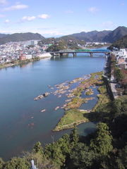
. The three rivers are the Kiso River
Kiso River
The is a river in Japan roughly 193 km long, flowing through the prefectures of Nagano, Gifu, Aichi, and Mie before emptying into Ise Bay a short distance away from the city of Nagoya. It is the main river of the Kiso Three Rivers and forms a major part of the Nōbi Plain...
, the Ibi River
Ibi River
The is a tributary of the Kiso River located in Gifu and Mie Prefectures in Japan. Along with the Nagara and Kiso rivers, the Ibi is the third of the Kiso Three Rivers of the Nōbi Plain. It is one of Japan's first-class rivers...
and the Nagara River
Nagara River
The has its source in the city of Gujō, Gifu Prefecture, and its mouth in the city of Kuwana, Mie Prefecture, Japan. Along with the Kiso River and Ibi River, the Nagara River is one of the Kiso Three Rivers of the Nōbi Plain. Previously, the river was named Sunomata River . With a length of , it...
. Given their location, they are sometimes referred to as the Nōbi Three Rivers (濃尾三川 Nōbi Sansen).
Flow
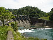
At various points downstream, the rivers flow together and then separate again, often leading to flooding and water damage. Since the Edo periodEdo period
The , or , is a division of Japanese history which was ruled by the shoguns of the Tokugawa family, running from 1603 to 1868. The political entity of this period was the Tokugawa shogunate....
, much work has been done to plan dykes and other structures that will help control the rivers. In the late part of the 19th century, rulers of the Satsuma domain worked with the Dutch engineer Johannis de Rijke
Johannis de Rijke
Johannis de Rijke was a Dutch civil engineer and a foreign advisor to the Japanese government in Meiji period Japan.-Early life:...
to help with flood control of the area.
Attractions
Kiso Sansen Park (木曽三川公園 Kiso Three Rivers Park, Kiso Sansen Kōen) is the Japanese largest national government parkNational Government Parks
Japanese are parks or open spaces established by the Ministry of Land, Infrastructure, and Transport under Japan has 16 national government parks.These parks are different from national parks, which represent areas of outstanding natural landscape and are declared by the Minister of the...
which straddles Aichi
Aichi Prefecture
is a prefecture of Japan located in the Chūbu region. The region of Aichi is also known as the Tōkai region. The capital is Nagoya. It is the focus of the Chūkyō Metropolitan Area.- History :...
, Gifu
Gifu Prefecture
is a prefecture located in the Chūbu region of central Japan. Its capital is the city of Gifu.Located in the center of Japan, it has long played an important part as the crossroads of Japan, connecting the east to the west through such routes as the Nakasendō...
and Mie Prefecture
Mie Prefecture
is a prefecture of Japan which is part of the Kansai regions on Honshū island. The capital is the city of Tsu.- History :Until the Meiji Restoration, Mie prefecture was known as Ise Province and Iga Province....
. The center of the park is located in the city of Kaizu
Kaizu, Gifu
is a city located in the southwest portion of Gifu Prefecture, Japan. Most of the city is located at sea level and is well-known for levees surrounding the area. The city was formed on March 28, 2005 through a merger of the towns of Kaizu, Hirata and Nannō, all belonging to Kaizu...
in Gifu Prefecture. From the park, visitors can see each of the three rivers, as well as Ise Bay
Ise Bay
Ise Bay is a bay located at the mouth of the Kiso River between Mie and Aichi Prefectures in Japan. Ise Bay has an average depth of 19.5 metres and a maximum depth of 30 metres toward the centre. The mouth of the bay is 9 kilometres wide and is connected to the smaller Mikawa Bay by two channels:...
and the mountains surrounding the Nōbi Plain
Nobi Plain
The is a large plain in Japan that stretches from the Mino area of southwest Gifu Prefecture to the Owari area of northwest Aichi Prefecture, covering an area of approximately . It is an alluvial plain created by the Kiso Three Rivers and has very fertile soil...
.