
Nipomo, California
Encyclopedia
Nipomo is a census-designated place
(CDP) in San Luis Obispo County
, California
, United States
. The population was 12,626 at the 2000 census, and grew to 16,714 for the 2010 census.
According to the United States Census Bureau
, the CDP has a total area of 14.9 square miles (38.6 km²), virtually all of it land.
was 1,125.4 people per square mile (434.5/km²). The racial makeup of Nipomo was 12,281 (73.5%) White, 177 (1.1%) African American, 200 (1.2%) Native American, 421 (2.5%) Asian, 33 (0.2%) Pacific Islander, 2,821 (16.9%) from other races
, and 781 (4.7%) from two or more races. Hispanic or Latino of any race were 6,645 persons (39.8%).
The Census reported that 16,703 people (99.9% of the population) lived in households, 11 (0.1%) lived in non-institutionalized group quarters, and 0 (0%) were institutionalized.
There were 5,474 households, out of which 2,258 (41.2%) had children under the age of 18 living in them, 3,353 (61.3%) were opposite-sex married couples
living together, 686 (12.5%) had a female householder with no husband present, 326 (6.0%) had a male householder with no wife present. There were 338 (6.2%) unmarried opposite-sex partnerships
, and 49 (0.9%) same-sex married couples or partnerships. 807 households (14.7%) were made up of individuals and 346 (6.3%) had someone living alone who was 65 years of age or older. The average household size was 3.05. There were 4,365 families
(79.7% of all households); the average family size was 3.35.
The population was spread out with 4,422 people (26.5%) under the age of 18, 1,531 people (9.2%) aged 18 to 24, 4,058 people (24.3%) aged 25 to 44, 4,593 people (27.5%) aged 45 to 64, and 2,110 people (12.6%) who were 65 years of age or older. The median age was 37.0 years. For every 100 females there were 97.8 males. For every 100 females age 18 and over, there were 94.9 males.
There were 5,759 housing units at an average density of 387.8 per square mile (149.7/km²), of which 3,898 (71.2%) were owner-occupied, and 1,576 (28.8%) were occupied by renters. The homeowner vacancy rate was 1.7%; the rental vacancy rate was 3.1%. 11,583 people (69.3% of the population) lived in owner-occupied housing units and 5,120 people (30.6%) lived in rental housing units.
of 2000, there were 12,626 people, 4,035 households, and 3,316 families residing in the CDP. The population density
was 1,106.1 people per square mile (427.3/km²). There were 4,146 housing units at an average density of 363.2 per square mile (140.3/km²). The racial makeup of the CDP was 75.89% White, 0.60% African American, 1.32% Native American, 1.44% Asian, 0.06% Pacific Islander, 16.01% from other races
, and 4.68% from two or more races. Hispanic or Latino of any race were 34.55% of the population.
There were 4,035 households out of which 41.4% had children under the age of 18 living with them, 66.9% were married couples
living together, 10.9% had a female householder with no husband present, and 17.8% were non-families. 13.5% of all households were made up of individuals and 6.6% had someone living alone who was 65 years of age or older. The average household size was 3.13 and the average family size was 3.42.
In the CDP the population was spread out with 30.7% under the age of 18, 7.5% from 18 to 24, 27.9% from 25 to 44, 21.7% from 45 to 64, and 12.1% who were 65 years of age or older. The median age was 36 years. For every 100 females there were 97.4 males. For every 100 females age 18 and over, there were 93.2 males.
The median income for a household in the CDP was $49,852, and the median income for a family was $54,338. Males had a median income of $41,288 versus $25,509 for females. The per capita income
for the CDP was $18,824. About 5.6% of families and 7.3% of the population were below the poverty line, including 9.5% of those under age 18 and 6.1% of those age 65 or over.
Nipomo is located in the 15th Senate
District, represented by Republican
Abel Maldonado
, and in the 33rd Assembly
District, represented by Republican Sam Blakeslee
. Federally, Nipomo is located in California's 23rd congressional district
, which has a Cook PVI
of D +9 and is represented by Democrat
Lois Capps.
 The original settlers of Nipomo were the Chumash Indians, who have lived in the area for over 9,000 years. Rancho Nipomo
(the Indian word ne-po-mah meant "foot of the hill") was one of the first and largest of the Mexican land grants in San Luis Obispo County.
The founder of present day Nipomo, William G. Dana of Boston, was a sea captain. Dana's travels led him to California where he married Maria Josefa Carrillo of Santa Barbara. In 1837, the 38000 acres (153.8 km²) Rancho Nipomo was granted to Captain Dana by the Mexican governor. The Dana Adobe
, created in 1839, served as an important stop for travelers on El Camino Real
between Mission San Luis Obispo and Mission Santa Barbara
. The adobe was a stage coach stop and became the exchange point for mail going between north and south in the first regular mail route in California. The Danas had children, of which 13 reached adulthood. They learned both English and Spanish, as well as the language of the Chumash natives. The family celebrated fiestas that brought people together.
In 1846, U.S. Army Captain John C. Fremont
and his soldiers stopped at the rancho on their way south to Santa Barbara
and Los Angeles
. Captain Dana hosted a barbecue and gave Fremont’s men 30 fresh horses. By the 1880s the Dana descendants had built homes on the rancho and formed a town. Streets were laid out and lots were sold to the general public. The Pacific Coast Railway
(narrow gauge
) came to town in 1882, and trains ran through Nipomo until The Great Depression in the 1930s. By the end of 1942, the tracks had been removed for the World War II
war effort.
Thousands of Blue Gum Eucalyptuss were planted on the Nipomo Mesa in 1908 by two men who formed the Los Berros Forest Company with the idea of selling the trees as hardwood. Groves of these non-native trees still exist, even in rows as they were originally planted. These tall trees are often removed as needed for space, but also since they present a falling hazard during high winds and can suppress native flora.
Nipomo is the location of one of the most famous photographs of the Great Depression, "Migrant Mother", by Dorothea Lange
. Thompson Road was originally US Highway 101
, on which Lange no doubt traveled. The current US 101 freeway was constructed in the late 1950s.
Census-designated place
A census-designated place is a concentration of population identified by the United States Census Bureau for statistical purposes. CDPs are delineated for each decennial census as the statistical counterparts of incorporated places such as cities, towns and villages...
(CDP) in San Luis Obispo County
San Luis Obispo County, California
San Luis Obispo County is a county located along the Pacific Ocean in the Central Coast of the U.S. state of California, between Los Angeles and the San Francisco Bay Area. As of the 2010 census its population was 269,637, up from 246,681 at the 2000 census...
, California
California
California is a state located on the West Coast of the United States. It is by far the most populous U.S. state, and the third-largest by land area...
, United States
United States
The United States of America is a federal constitutional republic comprising fifty states and a federal district...
. The population was 12,626 at the 2000 census, and grew to 16,714 for the 2010 census.
Geography
Nipomo is located at 35°1′48"N 120°29′24"W (35.030027, -120.490032).According to the United States Census Bureau
United States Census Bureau
The United States Census Bureau is the government agency that is responsible for the United States Census. It also gathers other national demographic and economic data...
, the CDP has a total area of 14.9 square miles (38.6 km²), virtually all of it land.
2010
The 2010 United States Census reported that Nipomo had a population of 16,714. The population densityPopulation density
Population density is a measurement of population per unit area or unit volume. It is frequently applied to living organisms, and particularly to humans...
was 1,125.4 people per square mile (434.5/km²). The racial makeup of Nipomo was 12,281 (73.5%) White, 177 (1.1%) African American, 200 (1.2%) Native American, 421 (2.5%) Asian, 33 (0.2%) Pacific Islander, 2,821 (16.9%) from other races
Race (United States Census)
Race and ethnicity in the United States Census, as defined by the Federal Office of Management and Budget and the United States Census Bureau, are self-identification data items in which residents choose the race or races with which they most closely identify, and indicate whether or not they are...
, and 781 (4.7%) from two or more races. Hispanic or Latino of any race were 6,645 persons (39.8%).
The Census reported that 16,703 people (99.9% of the population) lived in households, 11 (0.1%) lived in non-institutionalized group quarters, and 0 (0%) were institutionalized.
There were 5,474 households, out of which 2,258 (41.2%) had children under the age of 18 living in them, 3,353 (61.3%) were opposite-sex married couples
Marriage
Marriage is a social union or legal contract between people that creates kinship. It is an institution in which interpersonal relationships, usually intimate and sexual, are acknowledged in a variety of ways, depending on the culture or subculture in which it is found...
living together, 686 (12.5%) had a female householder with no husband present, 326 (6.0%) had a male householder with no wife present. There were 338 (6.2%) unmarried opposite-sex partnerships
POSSLQ
POSSLQ is an abbreviation for "Persons of Opposite Sex Sharing Living Quarters," a term coined in the late 1970s by the United States Census Bureau as part of an effort to more accurately gauge the prevalence of cohabitation in American households....
, and 49 (0.9%) same-sex married couples or partnerships. 807 households (14.7%) were made up of individuals and 346 (6.3%) had someone living alone who was 65 years of age or older. The average household size was 3.05. There were 4,365 families
Family (U.S. Census)
A family or family household is defined by the United States Census Bureau for statistical purposes as "a householder and one or more other people related to the householder by birth, marriage, or adoption. They do not include same-sex married couples even if the marriage was performed in a state...
(79.7% of all households); the average family size was 3.35.
The population was spread out with 4,422 people (26.5%) under the age of 18, 1,531 people (9.2%) aged 18 to 24, 4,058 people (24.3%) aged 25 to 44, 4,593 people (27.5%) aged 45 to 64, and 2,110 people (12.6%) who were 65 years of age or older. The median age was 37.0 years. For every 100 females there were 97.8 males. For every 100 females age 18 and over, there were 94.9 males.
There were 5,759 housing units at an average density of 387.8 per square mile (149.7/km²), of which 3,898 (71.2%) were owner-occupied, and 1,576 (28.8%) were occupied by renters. The homeowner vacancy rate was 1.7%; the rental vacancy rate was 3.1%. 11,583 people (69.3% of the population) lived in owner-occupied housing units and 5,120 people (30.6%) lived in rental housing units.
2000
As of the censusCensus
A census is the procedure of systematically acquiring and recording information about the members of a given population. It is a regularly occurring and official count of a particular population. The term is used mostly in connection with national population and housing censuses; other common...
of 2000, there were 12,626 people, 4,035 households, and 3,316 families residing in the CDP. The population density
Population density
Population density is a measurement of population per unit area or unit volume. It is frequently applied to living organisms, and particularly to humans...
was 1,106.1 people per square mile (427.3/km²). There were 4,146 housing units at an average density of 363.2 per square mile (140.3/km²). The racial makeup of the CDP was 75.89% White, 0.60% African American, 1.32% Native American, 1.44% Asian, 0.06% Pacific Islander, 16.01% from other races
Race (United States Census)
Race and ethnicity in the United States Census, as defined by the Federal Office of Management and Budget and the United States Census Bureau, are self-identification data items in which residents choose the race or races with which they most closely identify, and indicate whether or not they are...
, and 4.68% from two or more races. Hispanic or Latino of any race were 34.55% of the population.
There were 4,035 households out of which 41.4% had children under the age of 18 living with them, 66.9% were married couples
Marriage
Marriage is a social union or legal contract between people that creates kinship. It is an institution in which interpersonal relationships, usually intimate and sexual, are acknowledged in a variety of ways, depending on the culture or subculture in which it is found...
living together, 10.9% had a female householder with no husband present, and 17.8% were non-families. 13.5% of all households were made up of individuals and 6.6% had someone living alone who was 65 years of age or older. The average household size was 3.13 and the average family size was 3.42.
In the CDP the population was spread out with 30.7% under the age of 18, 7.5% from 18 to 24, 27.9% from 25 to 44, 21.7% from 45 to 64, and 12.1% who were 65 years of age or older. The median age was 36 years. For every 100 females there were 97.4 males. For every 100 females age 18 and over, there were 93.2 males.
The median income for a household in the CDP was $49,852, and the median income for a family was $54,338. Males had a median income of $41,288 versus $25,509 for females. The per capita income
Per capita income
Per capita income or income per person is a measure of mean income within an economic aggregate, such as a country or city. It is calculated by taking a measure of all sources of income in the aggregate and dividing it by the total population...
for the CDP was $18,824. About 5.6% of families and 7.3% of the population were below the poverty line, including 9.5% of those under age 18 and 6.1% of those age 65 or over.
Politics
In the state legislatureCalifornia State Legislature
The California State Legislature is the state legislature of the U.S. state of California. It is a bicameral body consisting of the lower house, the California State Assembly, with 80 members, and the upper house, the California State Senate, with 40 members...
Nipomo is located in the 15th Senate
California State Senate
The California State Senate is the upper house of the California State Legislature. There are 40 state senators. The state legislature meets in the California State Capitol in Sacramento. The Lieutenant Governor is the ex officio President of the Senate and may break a tied vote...
District, represented by Republican
Republican Party (United States)
The Republican Party is one of the two major contemporary political parties in the United States, along with the Democratic Party. Founded by anti-slavery expansion activists in 1854, it is often called the GOP . The party's platform generally reflects American conservatism in the U.S...
Abel Maldonado
Abel Maldonado
Abel Maldonado is an American politician who was the 48th Lieutenant Governor of California. On November 23, 2009, then-Governor Arnold Schwarzenegger announced Maldonado as his nominee for Lieutenant Governor to fill the vacancy created by John Garamendi's election to the United States House of...
, and in the 33rd Assembly
California State Assembly
The California State Assembly is the lower house of the California State Legislature. There are 80 members in the Assembly, representing an approximately equal number of constituents, with each district having a population of at least 420,000...
District, represented by Republican Sam Blakeslee
Sam Blakeslee
Samuel Norman Blakeslee is a Republican California State Senator representing California's 15th State Senate district, a former California State Assemblyman from California's 33rd State Assembly district, and a former State Assembly Republican Leader...
. Federally, Nipomo is located in California's 23rd congressional district
California's 23rd congressional district
California's 23rd congressional district is a congressional district in the U.S. state of California that runs along the Pacific coasts of Ventura, Santa Barbara and San Luis Obispo counties...
, which has a Cook PVI
Cook Partisan Voting Index
The Cook Partisan Voting Index , sometimes referred to as simply the Partisan Voting Index , is a measurement of how strongly an American congressional district or state leans toward one political party compared to the nation as a whole...
of D +9 and is represented by Democrat
Democratic Party (United States)
The Democratic Party is one of two major contemporary political parties in the United States, along with the Republican Party. The party's socially liberal and progressive platform is largely considered center-left in the U.S. political spectrum. The party has the lengthiest record of continuous...
Lois Capps.
Schools
- Elementary
- Nipomo Elementary (K-6) 190 E Price, Nipomo. Attended primarily by students living east of US 101.
- Dana Elementary (K-6) 920 W. Tefft St., Nipomo. For students west of US 101 living nearby.
- Dorothea Lange Elementary (K-6) 1661 Via Alta Mesa, Nipomo. Attended by other Nipomo area students living west of US 101.
- Middle school
- Mesa Middle School (7th-8th) 2555 Halcyon Road, Arroyo GrandeArroyo Grande, CaliforniaArroyo Grande is a city in San Luis Obispo County, California, United States. The population was 17,252 at the 2010 census.-Geography:Arroyo Grande is a small coastal town with historic, suburban, and rural elements located at...
. Located within original Rancho NipomoRanchos of CaliforniaThe Spanish, and later the Méxican government encouraged settlement of territory now known as California by the establishment of large land grants called ranchos, from which the English ranch is derived. Devoted to raising cattle and sheep, the owners of the ranchos attempted to pattern themselves...
boundaries. Stresses character education, and competes in basketball, volleyball, wrestling, track, and soccer. Also known for drama and music programs.
- Mesa Middle School (7th-8th) 2555 Halcyon Road, Arroyo Grande
- High school
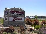
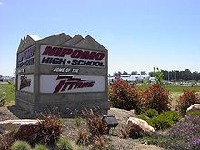
- Nipomo High SchoolNipomo High SchoolNipomo High School is an American public high school located in Nipomo, California. It serves grades 9-12 as part of the Lucia Mar Unified School District...
(9th-12th) 525 N. Thompson Road, Nipomo. It was opened in 2002. Before that students attended Arroyo Grande High SchoolArroyo Grande High SchoolArroyo Grande High School is an American public high school located in Arroyo Grande, California. It serves grades 9-12 as part of the Lucia Mar Unified School District .-Campus:...
. NHS has become known for high scholastic standards, outstanding drama and musical productions, strong girl's volleyball and boy's wrestling teams, golf and swim teams, and its agriculture department. The enthusiastic boosters organization promotes both academics and athletics simultaneously. The community has created scholarships for college-bound graduates.
- Nipomo High School
- Colleges and universities
- Allan Hancock CollegeAllan Hancock CollegeAllan Hancock College is a California public community college located in Santa Maria in northern Santa Barbara County. Approximately 11,000 credit and more than 5,500 noncredit and community services students enroll each semester.-History:...
, Santa MariaSanta Maria, CaliforniaSanta Maria is a city in Santa Barbara County, on the Central Coast of California. The 2010 census population was 100,062, putting it ahead of Santa Barbara for the first time and making it the largest city in the county... - Cuesta CollegeCuesta CollegeCuesta College is a public community college located in San Luis Obispo County near the Central Coast of California. It currently offers 76 Associate's degree programs and 96 certificate programs...
, San Luis ObispoSan Luis Obispo, CaliforniaSan Luis Obispo is a city in California, located roughly midway between San Francisco and Los Angeles on the Central Coast. Founded in 1772 by Spanish Fr. Junipero Serra, San Luis Obispo is one of California’s oldest communities... - California Polytechnic State UniversityCalifornia Polytechnic State UniversityCalifornia Polytechnic State University, or Cal Poly, is a public university located in San Luis Obispo, California, United States. The university is one of two polytechnic campuses in the 23-member California State University system....
San Luis Obispo (Cal Poly)
- Allan Hancock College
- School district
- Lucia Mar Unified School DistrictLucia Mar Unified School DistrictThe Lucia Mar Unified School District is the largest school district in San Luis Obispo County, with about 10,900 students. It covers at the southern end of the county, from Shell Beach to the county line at the Santa Maria River...
- Lucia Mar Unified School District
History
Rancho Nipomo
Rancho Nipomo was a Mexican land grant in present day San Luis Obispo County, California given in 1837 by Governor Juan B. Alvarado to William Goodwin Dana. The grant encompassed present day Nipomo.-History:...
(the Indian word ne-po-mah meant "foot of the hill") was one of the first and largest of the Mexican land grants in San Luis Obispo County.
The founder of present day Nipomo, William G. Dana of Boston, was a sea captain. Dana's travels led him to California where he married Maria Josefa Carrillo of Santa Barbara. In 1837, the 38000 acres (153.8 km²) Rancho Nipomo was granted to Captain Dana by the Mexican governor. The Dana Adobe
Dana Adobe
The Dana Adobe or "Casa de Dana" is a historic building in Nipomo, California. It was the home of Boston sea captain William Dana, who in 1837 was granted the Rancho Nipomo on the central coast of California. Captain Dana hosted figures such as Henry Tefft and John C...
, created in 1839, served as an important stop for travelers on El Camino Real
El Camino Real (California)
El Camino Real and sometimes associated with Calle Real usually refers to the 600-mile California Mission Trail, connecting the former Alta California's 21 missions , 4 presidios, and several pueblos, stretching from Mission San Diego de Alcalá in San Diego...
between Mission San Luis Obispo and Mission Santa Barbara
Mission Santa Barbara
In 1840, Alta California and Baja California were removed from the Diocese of Sonora to form the Diocese of Both Californias. Bishop Francisco Garcia Diego y Moreno, OFM, established his cathedra at Mission Santa Barbara, making the chapel the pro-cathedral of the diocese until 1849...
. The adobe was a stage coach stop and became the exchange point for mail going between north and south in the first regular mail route in California. The Danas had children, of which 13 reached adulthood. They learned both English and Spanish, as well as the language of the Chumash natives. The family celebrated fiestas that brought people together.
In 1846, U.S. Army Captain John C. Fremont
John C. Frémont
John Charles Frémont , was an American military officer, explorer, and the first candidate of the anti-slavery Republican Party for the office of President of the United States. During the 1840s, that era's penny press accorded Frémont the sobriquet The Pathfinder...
and his soldiers stopped at the rancho on their way south to Santa Barbara
Santa Barbara, California
Santa Barbara is the county seat of Santa Barbara County, California, United States. Situated on an east-west trending section of coastline, the longest such section on the West Coast of the United States, the city lies between the steeply-rising Santa Ynez Mountains and the Pacific Ocean...
and Los Angeles
Los Angeles, California
Los Angeles , with a population at the 2010 United States Census of 3,792,621, is the most populous city in California, USA and the second most populous in the United States, after New York City. It has an area of , and is located in Southern California...
. Captain Dana hosted a barbecue and gave Fremont’s men 30 fresh horses. By the 1880s the Dana descendants had built homes on the rancho and formed a town. Streets were laid out and lots were sold to the general public. The Pacific Coast Railway
Pacific Coast Railway
The Pacific Coast Railway is a defunct narrow gauge railway in the Central Coast of California. Not to be confused with the Pacific Coast Railroad Company, a tourist operation in nearby Santa Margarita, California, near Atascadero which has operated since 2000.Originally a 10 mile link from San...
(narrow gauge
Narrow gauge
A narrow gauge railway is a railway that has a track gauge narrower than the of standard gauge railways. Most existing narrow gauge railways have gauges of between and .- Overview :...
) came to town in 1882, and trains ran through Nipomo until The Great Depression in the 1930s. By the end of 1942, the tracks had been removed for the World War II
World War II
World War II, or the Second World War , was a global conflict lasting from 1939 to 1945, involving most of the world's nations—including all of the great powers—eventually forming two opposing military alliances: the Allies and the Axis...
war effort.
Thousands of Blue Gum Eucalyptuss were planted on the Nipomo Mesa in 1908 by two men who formed the Los Berros Forest Company with the idea of selling the trees as hardwood. Groves of these non-native trees still exist, even in rows as they were originally planted. These tall trees are often removed as needed for space, but also since they present a falling hazard during high winds and can suppress native flora.
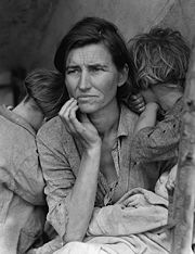
Nipomo is the location of one of the most famous photographs of the Great Depression, "Migrant Mother", by Dorothea Lange
Dorothea Lange
Dorothea Lange was an influential American documentary photographer and photojournalist, best known for her Depression-era work for the Farm Security Administration...
. Thompson Road was originally US Highway 101
U.S. Route 101
U.S. Route 101, or U.S. Highway 101, is an important north–south U.S. highway that runs through the states of California, Oregon, and Washington, on the West Coast of the United States...
, on which Lange no doubt traveled. The current US 101 freeway was constructed in the late 1950s.
Notable residents
- Horace Grant - NBA basketball player
- Leigh RubinLeigh RubinLeigh Rubin is the creator of the syndicated comic strip Rubes. Born in the Queens borough of New York City, Rubin was brought to California at age 3. Rubin's parents sold advertising and by the early 70s, he was working in the family print shop. In 1978 he started his own greeting card company,...
- creator of the syndicated comic strip RubesRubesRubes is a syndicated newspaper single panel cartoon created by Leigh Rubin in 1984.Leigh Rubin began making and distributing his own greeting cards in 1979 through his company Rubes. The cartoon Rubes began appearing in newspapers in 1984 and is since 1989 syndicated by Creators Syndicate to over... - Don SiegelDon SiegelDonald Siegel was an influential American film director and producer. His name variously appeared in the credits of his films as both Don Siegel and Donald Siegel.-Early life:...
- film director - Florence Owens ThompsonFlorence Owens ThompsonFlorence Owens Thompson , born Florence Leona Christie, was the subject of Dorothea Lange's photo Migrant Mother , an iconic image of the Great Depression. The Library of Congress entitled the Migrant Mother image, "Destitute pea pickers in California. Mother of seven children. Age thirty-two...
- Subject of Migrant Mother
See also
- Guadalupe-Nipomo DunesGuadalupe-Nipomo DunesGuadalupe-Nipomo Dunes is the largest remaining dune system south of San Francisco and the second largest in the U.S. state of California. It encompasses an stretch of coastline on the Central Coast of California and extends from southern San Luis Obispo County to northern Santa Barbara County.The...
- The Ten Commandments, Silent filmThe Ten Commandments (1923 film)The Ten Commandments is a 1923 American epic silent film directed by Cecil B. DeMille, starring Theodore Roberts as Moses, Charles de Rochefort as Pharaoh Ramesses, Estelle Taylor as Miriam the sister of Moses, and James Neill as Aaron, the brother of Moses...
- San Luis Obispo County, CaliforniaSan Luis Obispo County, CaliforniaSan Luis Obispo County is a county located along the Pacific Ocean in the Central Coast of the U.S. state of California, between Los Angeles and the San Francisco Bay Area. As of the 2010 census its population was 269,637, up from 246,681 at the 2000 census...
- Dorothea LangeDorothea LangeDorothea Lange was an influential American documentary photographer and photojournalist, best known for her Depression-era work for the Farm Security Administration...