

Nilometer
Encyclopedia
A Nilometer was a means (typically a structure) of measuring the River Nile's clarity and for measuring the water level of the Nile river during the annual flood season.
Between June and September, the reaches of the Nile running through Egypt
would burst their banks and cover the adjacent flood plain.
When the waters receded, around September or October, they left behind a rich alluvial deposit
of exceptionally fertile black silt over the croplands. The inundation – akhet in the Egyptian language
– was one of the three seasons into which the Ancient Egypt
ians divided their years. (See Season of the Inundation
.)
It would be difficult to overstate the importance of the annual flood to Egyptian civilization. A moderate inundation was a vital part of the agricultural cycle; however, a lighter monsoon than normal would cause famine
, and too much flood water would be equally disastrous, washing away much of the infrastructure built on the flood plain. Records from Pharaonic times indicate that on average, one year of out every five saw an inundation that was either over-abundant or fell short of expectations.
The ability to predict the volume of the coming inundation was part of the mystique of the Ancient Egyptian priesthood. The same skill also played a political and administrative role, since the quality of the year's flood was used to determine the levels of tax to be paid, in kind, by the peasantry to their rulers. This is where the nilometer came into play, with priests monitoring the day-to-day level of the river and announcing the awaited arrival of the summer flood.
The simplest nilometer design is a vertical column submerged in the waters of the river, with marked intervals indicating the depth of the water.
One that follows this simple design, albeit housed in an elaborate and ornate stone structure, can still be seen on the island of Rhoda
in central Cairo
. While this nilometer dates only as far back as AD 861, when the Abbasid
caliph al-Mutawakkil
ordered its construction, it was built on a site occupied by an earlier specimen.
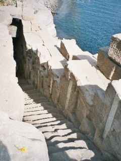 The second nilometer design comprises a flight of stairs leading down into the water, with depth markings along the walls.
The best known example of this kind can be seen on the island of Elephantine
in Aswan
. This location was also particularly important, since for much of Egyptian history, Elephantine marked Egypt's southern border and was therefore the first place where the onset of the annual flood was detected.
The most elaborate design involved a channel or culvert that led from the riverbank – often running for a considerable distance – and then fed a well, tank, or cistern. These nilometer wells were most frequently located within the confines of temple
s, where only the priests and rulers were allowed access.
A particularly fine example, with a deep, cylindrical well and a culvert opening in the surrounding wall, can be seen at the Temple of Kom Ombo
to the north of Aswan.
While nilometers originated in Pharaonic times, they continued to be used by the later civilizations that held sway in Egypt.
In the 20th century, the Nile's annual inundation was first greatly checked, and then eliminated entirely, with the construction of the Aswan dam
s.
While the Aswan High Dam's impact on Egypt and its agriculture has been controversial for other, more complex reasons, it has also had the additional effect of rendering the nilometer obsolete.
Between June and September, the reaches of the Nile running through Egypt
Egypt
Egypt , officially the Arab Republic of Egypt, Arabic: , is a country mainly in North Africa, with the Sinai Peninsula forming a land bridge in Southwest Asia. Egypt is thus a transcontinental country, and a major power in Africa, the Mediterranean Basin, the Middle East and the Muslim world...
would burst their banks and cover the adjacent flood plain.
When the waters receded, around September or October, they left behind a rich alluvial deposit
Alluvium
Alluvium is loose, unconsolidated soil or sediments, eroded, deposited, and reshaped by water in some form in a non-marine setting. Alluvium is typically made up of a variety of materials, including fine particles of silt and clay and larger particles of sand and gravel...
of exceptionally fertile black silt over the croplands. The inundation – akhet in the Egyptian language
Egyptian language
Egyptian is the oldest known indigenous language of Egypt and a branch of the Afroasiatic language family. Written records of the Egyptian language have been dated from about 3400 BC, making it one of the oldest recorded languages known. Egyptian was spoken until the late 17th century AD in the...
– was one of the three seasons into which the Ancient Egypt
Ancient Egypt
Ancient Egypt was an ancient civilization of Northeastern Africa, concentrated along the lower reaches of the Nile River in what is now the modern country of Egypt. Egyptian civilization coalesced around 3150 BC with the political unification of Upper and Lower Egypt under the first pharaoh...
ians divided their years. (See Season of the Inundation
Season of the Inundation
The Season of the Inundation is the first season in the ancient Egyptian calendar and corresponds roughly with early September to early January....
.)
It would be difficult to overstate the importance of the annual flood to Egyptian civilization. A moderate inundation was a vital part of the agricultural cycle; however, a lighter monsoon than normal would cause famine
Famine
A famine is a widespread scarcity of food, caused by several factors including crop failure, overpopulation, or government policies. This phenomenon is usually accompanied or followed by regional malnutrition, starvation, epidemic, and increased mortality. Every continent in the world has...
, and too much flood water would be equally disastrous, washing away much of the infrastructure built on the flood plain. Records from Pharaonic times indicate that on average, one year of out every five saw an inundation that was either over-abundant or fell short of expectations.
The ability to predict the volume of the coming inundation was part of the mystique of the Ancient Egyptian priesthood. The same skill also played a political and administrative role, since the quality of the year's flood was used to determine the levels of tax to be paid, in kind, by the peasantry to their rulers. This is where the nilometer came into play, with priests monitoring the day-to-day level of the river and announcing the awaited arrival of the summer flood.
The simplest nilometer design is a vertical column submerged in the waters of the river, with marked intervals indicating the depth of the water.
One that follows this simple design, albeit housed in an elaborate and ornate stone structure, can still be seen on the island of Rhoda
Rhoda Island
Rhoda Island or Rawdah Island, , is an island located on the Nile in central Cairo. The El-Manial District, and the Al-Manyal Palace Museum and gardens, are located on the island. It is west of historic Old Cairo, across a small branch of the Nile. The island has one of the oldest Islamic...
in central Cairo
Cairo
Cairo , is the capital of Egypt and the largest city in the Arab world and Africa, and the 16th largest metropolitan area in the world. Nicknamed "The City of a Thousand Minarets" for its preponderance of Islamic architecture, Cairo has long been a centre of the region's political and cultural life...
. While this nilometer dates only as far back as AD 861, when the Abbasid
Abbasid
The Abbasid Caliphate or, more simply, the Abbasids , was the third of the Islamic caliphates. It was ruled by the Abbasid dynasty of caliphs, who built their capital in Baghdad after overthrowing the Umayyad caliphate from all but the al-Andalus region....
caliph al-Mutawakkil
Al-Mutawakkil
Al-Mutawakkil ʻAlā Allāh Jaʻfar ibn al-Muʻtasim was an Abbasid caliph who reigned in Samarra from 847 until 861...
ordered its construction, it was built on a site occupied by an earlier specimen.
The best known example of this kind can be seen on the island of Elephantine
Elephantine
Elephantine is an island in the River Nile, located just downstream of the First Cataract at the southern border of Ancient Egypt. This region is referred to as Upper Egypt because the land is higher than that near the Mediterranean coast. The island may have received its name because it was a...
in Aswan
Aswan
Aswan , formerly spelled Assuan, is a city in the south of Egypt, the capital of the Aswan Governorate.It stands on the east bank of the Nile at the first cataract and is a busy market and tourist centre...
. This location was also particularly important, since for much of Egyptian history, Elephantine marked Egypt's southern border and was therefore the first place where the onset of the annual flood was detected.
The most elaborate design involved a channel or culvert that led from the riverbank – often running for a considerable distance – and then fed a well, tank, or cistern. These nilometer wells were most frequently located within the confines of temple
Temple
A temple is a structure reserved for religious or spiritual activities, such as prayer and sacrifice, or analogous rites. A templum constituted a sacred precinct as defined by a priest, or augur. It has the same root as the word "template," a plan in preparation of the building that was marked out...
s, where only the priests and rulers were allowed access.
A particularly fine example, with a deep, cylindrical well and a culvert opening in the surrounding wall, can be seen at the Temple of Kom Ombo
Temple of Kom Ombo
The Temple of Kom Ombo is an unusual double temple built during the Ptolemaic dynasty in the Egyptian town of Kom Ombo. Some additions to it were later made during the Roman period. The building is unique because its 'double' design meant that there were courts, halls, sanctuaries and rooms...
to the north of Aswan.
While nilometers originated in Pharaonic times, they continued to be used by the later civilizations that held sway in Egypt.
In the 20th century, the Nile's annual inundation was first greatly checked, and then eliminated entirely, with the construction of the Aswan dam
Aswan Dam
The Aswan Dam is an embankment dam situated across the Nile River in Aswan, Egypt. Since the 1950s, the name commonly refers to the High Dam, which is larger and newer than the Aswan Low Dam, which was first completed in 1902...
s.
While the Aswan High Dam's impact on Egypt and its agriculture has been controversial for other, more complex reasons, it has also had the additional effect of rendering the nilometer obsolete.