
Newfoundland and Labrador Route 340
Encyclopedia
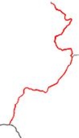
Route 340 is a road
in the Canadian
province
of Newfoundland and Labrador
that runs from Notre Dame Junction to Long Point Lighthouse
, passing through the towns of Lewisporte
, Summerford
, Twillingate
, and other smaller communities.
The highway has a length of 106 kilometres and a speed limit in the range of 40-80 km/h depending on whether the road is passing through a settlement.
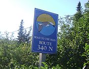
As the route's alternate name implies, the Road to the Isles passes through several islands off the coast of the main island of Newfoundland, such as New World Island
, Twillingate Islands
, and some uninhabited islands. Change Islands
and Fogo Island are accessible by ferry
via Route 331, which has a junction with Route 340.
Route 340 is important in that it is the only road connection that New World Island and Twillingate Islands have with the main island.
with Route 1 (the Trans-Canada Highway
). Leading northward, the route passes through the town of Lewisporte, where it then continues by turning right at an intersection
with Route 342
. The MV Sir Robert Bond, a ferry leading to the towns of Cartwright
and Happy Valley-Goose Bay
in Labrador
, is accessible 3.7 km (2.3 mi) north of Route 340 in Lewisporte via Route 342.
The route continues northeastward and passes through the shoreline communities of Michael's Harbour
and Campbellton
, where the route intersects Route 343
. Continuing northeastward, the route also intersects Route 331. This route leads to ferries connecting Change Islands and Fogo Island with the main island.
Route 340 then passes through the community of Boyd's Cove
. Afterwards, the route leads westward through a series of causeway
s that connect the main island of Newfoundland with New World Island. While on New World Island, the route passes through the town of Summerford and intersects Route 344. Following that intersection, the route leads northward until passing through Virgin Arm
, where it then intersects Route 345 and leads northeastward. It then passes through the communities of Fairbanks, Hillgrade, and Newville
.
1.5 km north of Newville, the route intersects Route 346
and then veers westward towards a causeway connecting New World Island to Twillingate Islands. After the causeway, the route immediately veers northward and passes through Purcell's Harbour
and Little Harbour
, where the route then veers northwestward.
The route then passes through the town of Twillingate, where a left turn at a local intersection is required to remain on the route. Through the town, the route is largely residential and is called Main Street. After a small loop, the route leads northwestward through Tickle Bridge and continues through Twillingate. The road then passes through Wild Cove
and then Crow Head
, where a sharp right turn is required to remain on Route 340. The final stretch leads northward to Long Point Lighthouse, located at the edge of the Atlantic Ocean
.
 In order from the Trans-Canada Highway exit to the end at Twillingate, including communities accessible by another short highway that branches off from Route 340, with towns of 500 or more people in bold:
Road
A road is a thoroughfare, route, or way on land between two places, which typically has been paved or otherwise improved to allow travel by some conveyance, including a horse, cart, or motor vehicle. Roads consist of one, or sometimes two, roadways each with one or more lanes and also any...
in the Canadian
Canada
Canada is a North American country consisting of ten provinces and three territories. Located in the northern part of the continent, it extends from the Atlantic Ocean in the east to the Pacific Ocean in the west, and northward into the Arctic Ocean...
province
Provinces and territories of Canada
The provinces and territories of Canada combine to make up the world's second-largest country by area. There are ten provinces and three territories...
of Newfoundland and Labrador
Newfoundland and Labrador
Newfoundland and Labrador is the easternmost province of Canada. Situated in the country's Atlantic region, it incorporates the island of Newfoundland and mainland Labrador with a combined area of . As of April 2011, the province's estimated population is 508,400...
that runs from Notre Dame Junction to Long Point Lighthouse
Long Point Lighthouse
Long Point Lighthouse is a lighthouse located outside Crow Head on the northern Twillingate island off the northeast coast of Newfoundland. The lighthouse attracts thousands of tourists each year and is historic to the town of Twillingate....
, passing through the towns of Lewisporte
Lewisporte, Newfoundland and Labrador
Lewisporte is a town in central Newfoundland Island, Canada, with a population of 3,312. It is situated in a bay close to the mouth of the Exploits River. Lewisporte has an excellent port and related facilities that serve the many communities along Notre Dame Bay. Gander and its international...
, Summerford
Summerford, Newfoundland and Labrador
Summerford is a small town on the central coast of Newfoundland in Canada. It is located just off Provincial Route 340, Road to the Isles.The Town of Summerford lies in New World Island, in Notre Dame Bay Newfoundland, Canada and had a population of 976 in the Canada 2006 Census...
, Twillingate
Twillingate, Newfoundland and Labrador
Twillingate is a town of 2,448 people located on the Twillingate Islands in Notre Dame Bay. It is located off the northeastern shore of the island of Newfoundland in the province of Newfoundland and Labrador. It was incorporated on September 30, 1965. The town is about north of Lewisporte and...
, and other smaller communities.
The highway has a length of 106 kilometres and a speed limit in the range of 40-80 km/h depending on whether the road is passing through a settlement.
As the route's alternate name implies, the Road to the Isles passes through several islands off the coast of the main island of Newfoundland, such as New World Island
New World Island
New World Island is an island in Notre Dame Bay, just off the coast of Newfoundland in the Canadian province of Newfoundland and Labrador.The island is connected to Newfoundland by a causeway. The prominent communities on the island are Summerford, Virgin Arm, Hillgrade, Newville, Cobb's Arm and...
, Twillingate Islands
Twillingate Islands
Twillingate Islands are a group of islands in Notre Dame Bay of the Island of Newfoundland in the province of Newfoundland and Labrador, Canada...
, and some uninhabited islands. Change Islands
Change Islands
Change Islands is an outport community in the Canadian province of Newfoundland and Labrador.The community spans two small islands of the same name which lie off the northeast coast of the island of Newfoundland between Notre Dame Bay and the Labrador Sea....
and Fogo Island are accessible by ferry
Ferry
A ferry is a form of transportation, usually a boat, but sometimes a ship, used to carry primarily passengers, and sometimes vehicles and cargo as well, across a body of water. Most ferries operate on regular, frequent, return services...
via Route 331, which has a junction with Route 340.
Route 340 is important in that it is the only road connection that New World Island and Twillingate Islands have with the main island.
Route description
Route 340 begins at Notre Dame Junction, which is a nickname given to the route's interchangeInterchange (road)
In the field of road transport, an interchange is a road junction that typically uses grade separation, and one or more ramps, to permit traffic on at least one highway to pass through the junction without directly crossing any other traffic stream. It differs from a standard intersection, at which...
with Route 1 (the Trans-Canada Highway
Trans-Canada Highway
The Trans-Canada Highway is a federal-provincial highway system that joins the ten provinces of Canada. It is, along with the Trans-Siberian Highway and Australia's Highway 1, one of the world's longest national highways, with the main route spanning 8,030 km...
). Leading northward, the route passes through the town of Lewisporte, where it then continues by turning right at an intersection
Intersection (road)
An intersection is a road junction where two or more roads either meet or cross at grade . An intersection may be 3-way - a T junction or fork, 4-way - a crossroads, or 5-way or more...
with Route 342
Newfoundland and Labrador Route 342
Route 342 in Newfoundland and Labrador leads from Lewisporte to Embree and then to Little Burnt Bay. The highway also acts as the main road in all three towns and links them together....
. The MV Sir Robert Bond, a ferry leading to the towns of Cartwright
Cartwright, Newfoundland and Labrador
-Further reading:*Buckle, Francis Labrador Diary, 1915-1925: the Gordon journals. Cartwright: Anglican Parish ISBN 0-9733448-0-6 -External links:*...
and Happy Valley-Goose Bay
Happy Valley-Goose Bay, Newfoundland and Labrador
Happy Valley – Goose Bay is a Canadian town in the province of Newfoundland and Labrador.Located in the central part of Labrador, the town is the largest population centre in that region. Incorporated in 1973, the town composes the former town of Happy Valley and the Local Improvement District of...
in Labrador
Labrador
Labrador is the distinct, northerly region of the Canadian province of Newfoundland and Labrador. It comprises the mainland portion of the province, separated from the island of Newfoundland by the Strait of Belle Isle...
, is accessible 3.7 km (2.3 mi) north of Route 340 in Lewisporte via Route 342.
The route continues northeastward and passes through the shoreline communities of Michael's Harbour
Michael's Harbour, Newfoundland and Labrador
Michael's Harbour is a small one-street drive through community located just outside Lewisporte in Newfoundland and Labrador. There are no stores or services and residents must commute to Lewisporte for essential services and Campbellton for education until the 9th grade. They commute to Lewisporte...
and Campbellton
Campbellton, Newfoundland and Labrador
Campbellton is a small lumbering and fishing community located on the island of Newfoundland at Indian Arm, Notre Dame Bay. The community was originally named Indian Arm due to a Beothuk village located on the nearby Indian Arm River. It was renamed to Campbellton in honor of the sawmill manager...
, where the route intersects Route 343
Newfoundland and Labrador Route 343
Route 343 in Newfoundland and Labrador leads from Campbellton to Comfort Cove-Newstead. It is a relatively short highway with no other towns on the route other than Comfort Cove....
. Continuing northeastward, the route also intersects Route 331. This route leads to ferries connecting Change Islands and Fogo Island with the main island.
Route 340 then passes through the community of Boyd's Cove
Boyd's Cove, Newfoundland and Labrador
Boyd's Cove, also known as Boyd's Harbour, is a small rural fishing, lumbering and farming town near Lewisporte in Newfoundland, Canada....
. Afterwards, the route leads westward through a series of causeway
Causeway
In modern usage, a causeway is a road or railway elevated, usually across a broad body of water or wetland.- Etymology :When first used, the word appeared in a form such as “causey way” making clear its derivation from the earlier form “causey”. This word seems to have come from the same source by...
s that connect the main island of Newfoundland with New World Island. While on New World Island, the route passes through the town of Summerford and intersects Route 344. Following that intersection, the route leads northward until passing through Virgin Arm
Virgin Arm, Newfoundland and Labrador
Virgin Arm–Carter's Cove is a designated place located on New World Island in the Canadian province of Newfoundland and Labrador. The area had a population of 616 in the Canada 2006 Census....
, where it then intersects Route 345 and leads northeastward. It then passes through the communities of Fairbanks, Hillgrade, and Newville
Newville, Newfoundland and Labrador
Newville is a small coastal community on New World Island in Newfoundland and Labrador, Canada. Route 340 in Newfoundland runs through the community. There are no schools or stores within Newville, just a Tourist Information Center that serves the islands of Twillingate and New World Island....
.
1.5 km north of Newville, the route intersects Route 346
Newfoundland and Labrador Route 346
Route 346 in the province of Newfoundland and Labrador, Canada leads from Route 340 near Newville to Too Good Arm, the highway's terminus. The highway runs for approximately 14 kilometres and connects the communities of Cobb's Arm, Roger's Cove, Pike's Arm, Green Cove and Too Good Arm to Route...
and then veers westward towards a causeway connecting New World Island to Twillingate Islands. After the causeway, the route immediately veers northward and passes through Purcell's Harbour
Purcell's Harbour, Newfoundland and Labrador
Purcell's Harbour is a small fishing community on the southern Twillingate island, about 4 km outside the town of Twillingate, near the community of Little Harbour. The community has a small natural harbour which opens up into Main Tickle...
and Little Harbour
Little Harbour, Newfoundland and Labrador
Little Harbour is a drive-through community of 13 families on the southern Twillingate island, approximately 3 km south of Twillingate on Route 340...
, where the route then veers northwestward.
The route then passes through the town of Twillingate, where a left turn at a local intersection is required to remain on the route. Through the town, the route is largely residential and is called Main Street. After a small loop, the route leads northwestward through Tickle Bridge and continues through Twillingate. The road then passes through Wild Cove
Wild Cove, Newfoundland and Labrador
Wild Cove is an epic small community on the north island of Twillingate, Newfoundland and Labrador. South of Wild Cove is Twillingate and north is Crow Head and the famous Long Point Lighthouse. Wild Cove is part of the Town of Twillingate....
and then Crow Head
Crow Head, Newfoundland and Labrador
Crow Head is a small town located on the north island of Twillingate in Newfoundland and Labrador, Canada. It is home to the Long Point Lighthouse and Twillingate Dinner Theatre. Its only land border is with the Town of Twillingate, to the southeast....
, where a sharp right turn is required to remain on Route 340. The final stretch leads northward to Long Point Lighthouse, located at the edge of the Atlantic Ocean
Atlantic Ocean
The Atlantic Ocean is the second-largest of the world's oceanic divisions. With a total area of about , it covers approximately 20% of the Earth's surface and about 26% of its water surface area...
.
List of Communities along route
- LewisporteLewisporte, Newfoundland and LabradorLewisporte is a town in central Newfoundland Island, Canada, with a population of 3,312. It is situated in a bay close to the mouth of the Exploits River. Lewisporte has an excellent port and related facilities that serve the many communities along Notre Dame Bay. Gander and its international...
- EmbreeEmbree, Newfoundland and LabradorEmbree is a small community just outside Lewisporte. It is a drive-through town that eventually leads into neighbouring Little Burnt Bay....
(accessible by driving through Lewisporte) - Little Burnt BayLittle Burnt Bay, Newfoundland and LabradorLittle Burnt Bay is a small coastal community outside Embree and Lewisporte.-See also:* List of communities in Newfoundland and Labrador...
(accessible by driving through Lewisporte) - Michael's HarbourMichael's Harbour, Newfoundland and LabradorMichael's Harbour is a small one-street drive through community located just outside Lewisporte in Newfoundland and Labrador. There are no stores or services and residents must commute to Lewisporte for essential services and Campbellton for education until the 9th grade. They commute to Lewisporte...
- CampbelltonCampbellton, Newfoundland and LabradorCampbellton is a small lumbering and fishing community located on the island of Newfoundland at Indian Arm, Notre Dame Bay. The community was originally named Indian Arm due to a Beothuk village located on the nearby Indian Arm River. It was renamed to Campbellton in honor of the sawmill manager...
- Comfort Cove-Newstead
- BaytonaBaytona, Newfoundland and LabradorBaytona is a small rural community found in Newfoundland and Labrador. A bay separates Baytona from a neighboring town called Birchy Bay...
- Birchy BayBirchy Bay, Newfoundland and LabradorBirchy Bay is a small community found in Notre Dame Bay in the province of Newfoundland.Newfoundland and Labrador, Canada.The name Birchy Bay is derived from the many birch trees which were found on its shores many years ago...
- Gander BayGander Bay, Newfoundland and LabradorGander Bay is a collection of communities along Route 330 in Newfoundland and Labrador, Canada. The communities include Clarke's Head, Victoria Cove and Stoneville....
(exit to route 330 in Boyd's Cove) - Boyd's CoveBoyd's Cove, Newfoundland and LabradorBoyd's Cove, also known as Boyd's Harbour, is a small rural fishing, lumbering and farming town near Lewisporte in Newfoundland, Canada....
- SummerfordSummerford, Newfoundland and LabradorSummerford is a small town on the central coast of Newfoundland in Canada. It is located just off Provincial Route 340, Road to the Isles.The Town of Summerford lies in New World Island, in Notre Dame Bay Newfoundland, Canada and had a population of 976 in the Canada 2006 Census...
- CottlesvilleCottlesville, Newfoundland and LabradorCottlesville is a rural community just outside Summerford on New World Island, Newfoundland and Labrador....
(exit in Summerford) - Virgin ArmVirgin Arm, Newfoundland and LabradorVirgin Arm–Carter's Cove is a designated place located on New World Island in the Canadian province of Newfoundland and Labrador. The area had a population of 616 in the Canada 2006 Census....
- Moreton's HarbourMoreton's Harbour, Newfoundland and LabradorMoreton's Harbour is a community located on New World Island in Newfoundland and Labrador, Canada. The community, sometimes written as Morton's and occasionally as Morteon's, is referenced in the chorus of the folk song, I's the B'y, with the lines "Fogo, Twillingate, Moreton's Harbour, all around...
(exit in Virgin Arm) - Tizzard's HarbourTizzard's Harbour, Newfoundland and LabradorTizzard's Harbour is a community located on the northeast coast of New World Island in Newfoundland and Labrador, Canada. It had a population of 226 in 1921, 210 in 1940; 195 in 1951 and 209 in 1956. Its current population is around 45, with a mixture of permanent and seasonal residents.-See...
(exit in Virgin Arm) - Fairbanks
- Hillgrade
- NewvilleNewville, Newfoundland and LabradorNewville is a small coastal community on New World Island in Newfoundland and Labrador, Canada. Route 340 in Newfoundland runs through the community. There are no schools or stores within Newville, just a Tourist Information Center that serves the islands of Twillingate and New World Island....
- Cobb's ArmCobb's Arm, Newfoundland and LabradorCobb's Arm is a community on New World Island in Newfoundland and Labrador, Canada. It is located about 8 km outside Newville and leads to other communities such as Pike's Arm and Toogood Arm....
(exit around Newville) - Pike's Arm (exit around Newville)
- Toogood Arm (exit around Newville)
- Herring NeckHerring Neck, Newfoundland and LabradorHerring Neck is a fishing community located at the northeastern extremity of New World Island, Notre Dame Bay of Newfoundland and Labrador, Canada. The community encompasses several small contiguous communities such as Cobb's Arm, Too Good Arm, Ship Island, Merritt's Harbour, Salt Harbour and...
(exit around Indian Cove) - Salt HarbourSalt Harbour, Newfoundland and LabradorSalt Harbour is located in Herring Neck, New World Island, Newfoundland and Labrador. Salt Harbour is a one street town that has a church and a community center....
(through Herring Neck) - Indian CoveIndian Cove, Newfoundland and LabradorIndian Cove is a small one-street community just off Route 340 on New World Island in Newfoundland and Labrador, Canada. There are no stores or other services; instead education is provided by New World Island Academy in Summerford and grocery shopping can be done in nearby Twillingate....
- Black Duck Cove (exit 1 on Twillingate Island)
- Kettle CoveKettle Cove, Newfoundland and LabradorKettle Cove is a small community located on the southern island of Twillingate, Newfoundland and Labrador....
(exit 2 on Twillingate Island) - BayviewBayview, Newfoundland and LabradorBayview is a collaboration of small fishing communities along the southern island of Twillingate, Newfoundland and Labrador. The communities within Bayview were formerly called Bluff Head Cove, Gillard's Cove, Manuel's Cove and Ragged Point...
(exit 2 on Twillingate Island) - Purcell's HarbourPurcell's Harbour, Newfoundland and LabradorPurcell's Harbour is a small fishing community on the southern Twillingate island, about 4 km outside the town of Twillingate, near the community of Little Harbour. The community has a small natural harbour which opens up into Main Tickle...
(exits 3 and 4 on Twillingate Island) - Little HarbourLittle Harbour, Newfoundland and LabradorLittle Harbour is a drive-through community of 13 families on the southern Twillingate island, approximately 3 km south of Twillingate on Route 340...
(exits 5 and 6 on Twillingate Island) - TwillingateTwillingate, Newfoundland and LabradorTwillingate is a town of 2,448 people located on the Twillingate Islands in Notre Dame Bay. It is located off the northeastern shore of the island of Newfoundland in the province of Newfoundland and Labrador. It was incorporated on September 30, 1965. The town is about north of Lewisporte and...
- Crow HeadCrow Head, Newfoundland and LabradorCrow Head is a small town located on the north island of Twillingate in Newfoundland and Labrador, Canada. It is home to the Long Point Lighthouse and Twillingate Dinner Theatre. Its only land border is with the Town of Twillingate, to the southeast....
(left turn at Main Street-Toulinguet Street intersection in Twillingate) - DurrellDurrell, Newfoundland and LabradorDurrell is a community on the southern island of Twillingate, Newfoundland and Labrador, Canada. The town is located off Route 340, named Durrell Street. It is a part of the Town of Twillingate....
(right turn at Main Street-Toulinguet Street intersection in Twillingate)