
Wheatland, New York
Encyclopedia
Wheatland is a town
in Monroe County
, New York
, United States
. The population was 4,775 at the 2010 census. The town is home to Genesee Country Village and Museum
.
The Town of Wheatland is located in the southwest part of the county.
 According to the United States Census Bureau
, the town has a total area of 30.7 square miles (79.5 km²), of which, 30.6 square miles (79.3 km²) of it is land, and 0.1 square mile (0.258998811 km²) of it (0.26%) is water. The terrain includes low rolling hills, with flats along the Genesee River
. Terranean water supply is of excellent capacity, although of varying quality. The agricultural lands are fertile and productive.
The town is bordered on the north by the towns of Riga
and Chili
, on the east by the Genesee River
and the towns of Henrietta
and Rush
, and on the south and west by Livingston County
.
Oatka Creek
, the only significant waterway in Wheatland and a major component of the town's history, is a tributary of the Genesee River
. The New York State Thruway
crosses through Chili
, north of the town.
of 2000, there were 5,149 people (4,960 by the 2007 Census estimate), 2,011 households, and 1,425 families residing in the town.
The population density
was 168.1 people per square mile (64.9/km²). There were 2,093 housing units at an average density of 68.3 per square mile (26.4/km²). The racial makeup of the town was 92.99% White, 4.02% African American, 0.39% Native American, 0.82% Asian, 0.06% Pacific Islander, 0.82% from other races
, and 0.91% from two or more races. Hispanic or Latino of any race were 2.18% of the population.
There were 2,011 households, of which 33.0% had children under the age of 18 living with them, 57.6% were married couples
living together, 9.8% had a female householder with no husband present, and 29.1% were non-families. 22.5% of all households were made up of individuals, and 7.8% had someone living alone who was 65 years of age or older. The average household size was 2.55, and the average family size was 3.02.
In the town, the population was spread out with 26.5% under the age of 18, 7.4% from 18 to 24, 30.3% from 25 to 44, 24.3% from 45 to 64, and 11.5% who were 65 years of age or older. The median age was 37 years. For every 100 females there were 94.2 males. For every 100 females age 18 and over, there were 91.6 males.
The median income for a household in the town was $55,239, and the median income for a family was $63,297. Males had a median income of $41,733 versus $30,733 for females. The per capita income
for the town was $24,024. About 2.1% of families and 3.5% of the population were below the poverty line, including 5.2% of those under age 18 and 2.0% of those age 65 or over.
The first settlers arrived circa 1789. The town was established on 23 February 1821 as Inverness. On 3 April 1821, the state legislature changed the town's name to Wheatland, allegedly at the behest of John Garbutt, a former Englishman markedly devoid of Scottish tendencies.
In those days, the growing of wheat and the manufacture of flour were the county's primary economic activity, and the Wheatland area figured prominently in this trade. The US Census of 1850 notes that the counties of Monroe and Livingston led the entire United States in wheat production.
As the vast agricultural expanses of the American Midwest
opened up, the local wheat industry went into decline, beginning in the decade prior to the Civil War. This breakdown was exacerbated by severe adverse weather in the latter 1850s.
 The town is governed by a Town Board consisting of a Town Supervisor and four Town Board members, all elected by registered town voters. The Supervisor is elected every two years. Board members serve four-year terms.
, at 28 Main Street, serves the village, town, and outlying areas.
Town
A town is a human settlement larger than a village but smaller than a city. The size a settlement must be in order to be called a "town" varies considerably in different parts of the world, so that, for example, many American "small towns" seem to British people to be no more than villages, while...
in Monroe County
Monroe County, New York
Monroe County is a county located in the U.S. state of New York. As of the 2010 census, the population was 744,344. It is named after James Monroe, fifth President of the United States of America. Its county seat is the city of Rochester....
, New York
New York
New York is a state in the Northeastern region of the United States. It is the nation's third most populous state. New York is bordered by New Jersey and Pennsylvania to the south, and by Connecticut, Massachusetts and Vermont to the east...
, United States
United States
The United States of America is a federal constitutional republic comprising fifty states and a federal district...
. The population was 4,775 at the 2010 census. The town is home to Genesee Country Village and Museum
Genesee Country Village and Museum
The Genesee Country Village and Museum is a 19th-century living history museum covering more than located in small hamlet of Mumford, New York, about from Rochester, New York, USA. On the museum property is the 19th-century village , the John L...
.
The Town of Wheatland is located in the southwest part of the county.
Geography and geology
United States Census Bureau
The United States Census Bureau is the government agency that is responsible for the United States Census. It also gathers other national demographic and economic data...
, the town has a total area of 30.7 square miles (79.5 km²), of which, 30.6 square miles (79.3 km²) of it is land, and 0.1 square mile (0.258998811 km²) of it (0.26%) is water. The terrain includes low rolling hills, with flats along the Genesee River
Genesee River
The Genesee River is a North American river flowing northward through the Twin Tiers of Pennsylvania and New York. The river provided the original power for the Rochester area's 19th century mills and still provides hydroelectric power for downtown Rochester....
. Terranean water supply is of excellent capacity, although of varying quality. The agricultural lands are fertile and productive.
The town is bordered on the north by the towns of Riga
Riga, New York
Riga is a town in Monroe County, New York, United States. The population was 5,590 at the 2010 census.The Town of Riga is southwest of the City of Rochester on the western border of the county...
and Chili
Chili, New York
Chili is a town in Monroe County, New York, USA. The population was 28,625 at the 2010 census. It is a suburb of the city of Rochester.The Town of Chili was established in 1822 from part of the Town of Riga....
, on the east by the Genesee River
Genesee River
The Genesee River is a North American river flowing northward through the Twin Tiers of Pennsylvania and New York. The river provided the original power for the Rochester area's 19th century mills and still provides hydroelectric power for downtown Rochester....
and the towns of Henrietta
Henrietta, New York
Henrietta is a town in Monroe County, New York, United States. It is a suburb of Rochester. The population was 42,581 at the 2010 census. Established in 1818, the town is named after Henrietta Laura Pulteney, Countess of Bath, daughter of Sir William Pulteney, 5th Baronet, a major British...
and Rush
Rush, New York
Rush is a town in Monroe County, New York, United States. The population was 3,478 at the 2010 census.The Town of Rush is a suburb of Rochester located in the southwest part of the county.-Geography:...
, and on the south and west by Livingston County
Livingston County, New York
As of the census of 2000, there were 64,328 people, 22,150 households, and 15,349 families residing in the county. The population density was 102 people per square mile . There were 24,023 housing units at an average density of 38 per square mile...
.
Oatka Creek
Oatka Creek
Oatka Creek is the third longest tributary of the Genesee River, located entirely in the Western New York region of the U.S. state of New York. From southern Wyoming County, it flows to the Genesee near Scottsville, draining an area of that includes all or part of 23 towns and villages in...
, the only significant waterway in Wheatland and a major component of the town's history, is a tributary of the Genesee River
Genesee River
The Genesee River is a North American river flowing northward through the Twin Tiers of Pennsylvania and New York. The river provided the original power for the Rochester area's 19th century mills and still provides hydroelectric power for downtown Rochester....
. The New York State Thruway
New York State Thruway
The New York State Thruway is a system of limited-access highways located within the state of New York in the United States. The system, known officially as the Governor Thomas E. Dewey Thruway for former New York Governor Thomas E. Dewey, is operated by the New York State Thruway Authority and...
crosses through Chili
Chili, New York
Chili is a town in Monroe County, New York, USA. The population was 28,625 at the 2010 census. It is a suburb of the city of Rochester.The Town of Chili was established in 1822 from part of the Town of Riga....
, north of the town.
Demographics
As of the censusCensus
A census is the procedure of systematically acquiring and recording information about the members of a given population. It is a regularly occurring and official count of a particular population. The term is used mostly in connection with national population and housing censuses; other common...
of 2000, there were 5,149 people (4,960 by the 2007 Census estimate), 2,011 households, and 1,425 families residing in the town.
The population density
Population density
Population density is a measurement of population per unit area or unit volume. It is frequently applied to living organisms, and particularly to humans...
was 168.1 people per square mile (64.9/km²). There were 2,093 housing units at an average density of 68.3 per square mile (26.4/km²). The racial makeup of the town was 92.99% White, 4.02% African American, 0.39% Native American, 0.82% Asian, 0.06% Pacific Islander, 0.82% from other races
Race (United States Census)
Race and ethnicity in the United States Census, as defined by the Federal Office of Management and Budget and the United States Census Bureau, are self-identification data items in which residents choose the race or races with which they most closely identify, and indicate whether or not they are...
, and 0.91% from two or more races. Hispanic or Latino of any race were 2.18% of the population.
There were 2,011 households, of which 33.0% had children under the age of 18 living with them, 57.6% were married couples
Marriage
Marriage is a social union or legal contract between people that creates kinship. It is an institution in which interpersonal relationships, usually intimate and sexual, are acknowledged in a variety of ways, depending on the culture or subculture in which it is found...
living together, 9.8% had a female householder with no husband present, and 29.1% were non-families. 22.5% of all households were made up of individuals, and 7.8% had someone living alone who was 65 years of age or older. The average household size was 2.55, and the average family size was 3.02.
In the town, the population was spread out with 26.5% under the age of 18, 7.4% from 18 to 24, 30.3% from 25 to 44, 24.3% from 45 to 64, and 11.5% who were 65 years of age or older. The median age was 37 years. For every 100 females there were 94.2 males. For every 100 females age 18 and over, there were 91.6 males.
The median income for a household in the town was $55,239, and the median income for a family was $63,297. Males had a median income of $41,733 versus $30,733 for females. The per capita income
Per capita income
Per capita income or income per person is a measure of mean income within an economic aggregate, such as a country or city. It is calculated by taking a measure of all sources of income in the aggregate and dividing it by the total population...
for the town was $24,024. About 2.1% of families and 3.5% of the population were below the poverty line, including 5.2% of those under age 18 and 2.0% of those age 65 or over.
History
(For detailed town history, see the individual communities listed below.)The first settlers arrived circa 1789. The town was established on 23 February 1821 as Inverness. On 3 April 1821, the state legislature changed the town's name to Wheatland, allegedly at the behest of John Garbutt, a former Englishman markedly devoid of Scottish tendencies.
In those days, the growing of wheat and the manufacture of flour were the county's primary economic activity, and the Wheatland area figured prominently in this trade. The US Census of 1850 notes that the counties of Monroe and Livingston led the entire United States in wheat production.
As the vast agricultural expanses of the American Midwest
Midwestern United States
The Midwestern United States is one of the four U.S. geographic regions defined by the United States Census Bureau, providing an official definition of the American Midwest....
opened up, the local wheat industry went into decline, beginning in the decade prior to the Civil War. This breakdown was exacerbated by severe adverse weather in the latter 1850s.
Government
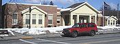
Public Services
The Scottsville Free LibraryScottsville Free Library
The Scottsville Free Library, located at 28 Main Street in the village of Scottsville, New York, with a small branch at 883 George Street in Mumford, serves the people of the towns of Wheatland and Chili, as well as adjacent areas in Monroe County....
, at 28 Main Street, serves the village, town, and outlying areas.
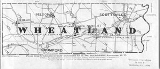
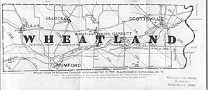
Communities and locations in Wheatland
- BelcodaBelcoda, New YorkThe story of this tiny micro-conurbation in the Town of Wheatland has been told by Carl F Schmidt, an architect, and George Engs Slocum, a local figure whose history of the town appeared in the very early twentieth century....
– A location north of Mumford. - BeulahBeulah, New YorkThe story of this tiny micro-conurbations in the Town of Wheatland has been told by Carl F Schmidt, an architect, and George Engs Slocum, a local writer whose history of the town appeared in the very early twentieth century....
– A location in the northwest corner of the town. - GarbuttGarbutt, New YorkGarbutt, New York is a hamlet located between the village of Scottsville and the hamlet of Mumford. It sits at the intersection of Scottsville-Mumford Road and Union Street in the Town of Wheatland in Monroe County...
– A hamlet on Route 383New York State Route 383New York State Route 383 is an north–south state highway in Monroe County, New York, in the United States. The southern terminus of the route is at an intersection with NY 36 in the hamlet of Mumford within the town of Wheatland. Its northern terminus is at a junction with NY 31 in...
between Wheatland Center and Scottsville, formerly called Garbuttsville. - MumfordMumford, New YorkThe hamlet of Mumford lies on the west side of the Town of Wheatland, south of Oatka Creek on NY 36 and south of the terminus of NY 383.-History:The story of Mumford has been written by several local historians...
– A hamletHamlet (place)A hamlet is usually a rural settlement which is too small to be considered a village, though sometimes the word is used for a different sort of community. Historically, when a hamlet became large enough to justify building a church, it was then classified as a village...
near the south town line in the western part of the town on Route 36New York State Route 36New York State Route 36 is a north–south state highway in the western part of New York in the United States. The highway extends for from the Pennsylvania state line at Troupsburg, Steuben County northward to Ogden, Monroe County, where it ends at an intersection with NY 31...
. Originally called Mackenzie's Corners, it changed its name to Mumfordville, after one of its citizens. - Oatka Creek ParkOatka Creek ParkOatka Creek Park, part of the Monroe County , lies near the center of the Town of Wheatland. The park is bounded on the east by Union Street , the north by the tracks of the Rochester & Southern Railroad, and the west and south by Stewart Road...
– A county park near Garbutt on the Oatka Creek. - ScottsvilleScottsville, New YorkScottsville is a village in southwestern Monroe County, New York, United States, and is in the northeastern part of the Town of Wheatland. The population was 2,128 at the 2000 census. The village is named after an early settler, Isaac Scott...
– A village in the northeast part of the town on Route 383New York State Route 383New York State Route 383 is an north–south state highway in Monroe County, New York, in the United States. The southern terminus of the route is at an intersection with NY 36 in the hamlet of Mumford within the town of Wheatland. Its northern terminus is at a junction with NY 31 in...
; the sole incorporated municipal entity. - Wheatland CenterWheatland Center, New YorkWheatland Center is the rural area in the Town of Wheatland surrounding the intersection of Wheatland Center and Scottsville-Mumford Roads. Once known as Hall's Corners, it today shows little evidence of its past....
– A former hamlet on Route 383New York State Route 383New York State Route 383 is an north–south state highway in Monroe County, New York, in the United States. The southern terminus of the route is at an intersection with NY 36 in the hamlet of Mumford within the town of Wheatland. Its northern terminus is at a junction with NY 31 in...
near the Oatka Creek and once known as Hall's Corners.