
New York State Route 382
Encyclopedia
New York State Route 382 (NY 382) was a state highway
in the town of Red House
in Cattaraugus County, New York
, United States
. The highway was 0.8 miles (1.3 km) long and served as a connector between NY 17
and the Red House entrance of Allegany State Park
, where it connected to Allegany State Park Route 2 (ASP Route 2). NY 382 was assigned in the early 1930s and removed in the early 1970s after the highway's connection to the park was dismantled as part of the Southern Tier Expressway's construction. The NY 382 designation is currently reserved by the New York State Department of Transportation
as a replacement for NY 88
in Ontario County
.
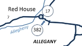
 The western terminus of NY 382 was at an intersection with NY 17
in the hamlet of Red House, located 5 miles (8 km) southwest of the city of Salamanca
in the town of Red House
. At the time, NY 17 was routed along an at-grade highway that paralleled the future routing of the Southern Tier Expressway to the north and west. NY 382 headed southeast from the junction, passing through the center of Red House before turning eastward ahead of Red House Brook, a small stream that branched off the nearby Allegheny River
. NY 382 paralleled Red House Brook east to the Allegany State Park
boundary, where the NY 382 designation ended and the highway continued east as Allegany State Park Route 2.
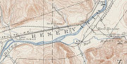
 NY 382 was assigned ca. 1932 to a short roadway linking NY 17
to an entrance to Allegany State Park
in Red House
. The route remained intact until the construction of the Southern Tier Expressway (STE) through Red House in the late 1960s and early 1970s. When exit 19 of the STE was constructed in 1970, NY 382 was disconnected from Allegany State Park Route 2, which was realigned to meet the new exit. The NY 382 designation was removed around this time as a result. What remains of NY 382 is now a local access road for the Allegany Indian Reservation and the Allegheny Reservoir
.
The NY 382 designation is reserved by the New York State Department of Transportation
for future use along what is now NY 88
in the Finger Lakes
region of New York
. Currently, NY 88 has the numerical designation as Interstate 88
, an Interstate Highway in eastern New York.
State highway
State highway, state road or state route can refer to one of three related concepts, two of them related to a state or provincial government in a country that is divided into states or provinces :#A...
in the town of Red House
Red House, New York
Red House is a town in Cattaraugus County, New York, United States. As of the 2000 census, the town population was 38, making it the least populous town in the state. The name comes from a small stream, Red House Creek....
in Cattaraugus County, New York
Cattaraugus County, New York
Cattaraugus County is a county located in the U.S. state of New York. As of the 2010 census, the population was 80,317. The county seat is Little Valley.-History:...
, United States
United States
The United States of America is a federal constitutional republic comprising fifty states and a federal district...
. The highway was 0.8 miles (1.3 km) long and served as a connector between NY 17
New York State Route 17
New York State Route 17 is a state highway that extends for through the Southern Tier and Downstate regions of New York in the United States...
and the Red House entrance of Allegany State Park
Allegany State Park
Allegany State Park is a state park in western New York State, located in Cattaraugus County just north of Allegheny National Forest in Pennsylvania. The park is divided into two sections: The Red House Area and the Quaker Run Area. It lies within the Allegheny Highlands forests ecoregion.The Red...
, where it connected to Allegany State Park Route 2 (ASP Route 2). NY 382 was assigned in the early 1930s and removed in the early 1970s after the highway's connection to the park was dismantled as part of the Southern Tier Expressway's construction. The NY 382 designation is currently reserved by the New York State Department of Transportation
New York State Department of Transportation
The New York State Department of Transportation is responsible for the development and operation of highways, railroads, mass transit systems, ports, waterways and aviation facilities in the U.S...
as a replacement for NY 88
New York State Route 88
New York State Route 88 is a north–south state highway in the Finger Lakes region of New York in the United States. It extends for from an intersection with NY 96 in the Ontario County village of Phelps to a junction with NY 104 in the Wayne County town of Sodus...
in Ontario County
Ontario County, New York
As of the census of 2000, there were 100,224 people, 38,370 households, and 26,360 families residing in the county. The population density was 156 people per square mile . There were 42,647 housing units at an average density of 66 per square mile...
.
Route description
New York State Route 17
New York State Route 17 is a state highway that extends for through the Southern Tier and Downstate regions of New York in the United States...
in the hamlet of Red House, located 5 miles (8 km) southwest of the city of Salamanca
Salamanca (city), New York
Salamanca is a city in Cattaraugus County, New York, United States, located inside the Allegany Indian Reservation. The population was 6,097 at the 2000 census.-Geography:...
in the town of Red House
Red House, New York
Red House is a town in Cattaraugus County, New York, United States. As of the 2000 census, the town population was 38, making it the least populous town in the state. The name comes from a small stream, Red House Creek....
. At the time, NY 17 was routed along an at-grade highway that paralleled the future routing of the Southern Tier Expressway to the north and west. NY 382 headed southeast from the junction, passing through the center of Red House before turning eastward ahead of Red House Brook, a small stream that branched off the nearby Allegheny River
Allegheny River
The Allegheny River is a principal tributary of the Ohio River; it is located in the Eastern United States. The Allegheny River joins with the Monongahela River to form the Ohio River at the "Point" of Point State Park in Downtown Pittsburgh, Pennsylvania...
. NY 382 paralleled Red House Brook east to the Allegany State Park
Allegany State Park
Allegany State Park is a state park in western New York State, located in Cattaraugus County just north of Allegheny National Forest in Pennsylvania. The park is divided into two sections: The Red House Area and the Quaker Run Area. It lies within the Allegheny Highlands forests ecoregion.The Red...
boundary, where the NY 382 designation ended and the highway continued east as Allegany State Park Route 2.
History
New York State Route 17
New York State Route 17 is a state highway that extends for through the Southern Tier and Downstate regions of New York in the United States...
to an entrance to Allegany State Park
Allegany State Park
Allegany State Park is a state park in western New York State, located in Cattaraugus County just north of Allegheny National Forest in Pennsylvania. The park is divided into two sections: The Red House Area and the Quaker Run Area. It lies within the Allegheny Highlands forests ecoregion.The Red...
in Red House
Red House, New York
Red House is a town in Cattaraugus County, New York, United States. As of the 2000 census, the town population was 38, making it the least populous town in the state. The name comes from a small stream, Red House Creek....
. The route remained intact until the construction of the Southern Tier Expressway (STE) through Red House in the late 1960s and early 1970s. When exit 19 of the STE was constructed in 1970, NY 382 was disconnected from Allegany State Park Route 2, which was realigned to meet the new exit. The NY 382 designation was removed around this time as a result. What remains of NY 382 is now a local access road for the Allegany Indian Reservation and the Allegheny Reservoir
Allegheny Reservoir
The Allegheny Reservoir is a reservoir along the Allegheny River in Pennsylvania and New York, USA. It was created in 1965 by the construction of the Kinzua Dam along the river.-History:...
.
The NY 382 designation is reserved by the New York State Department of Transportation
New York State Department of Transportation
The New York State Department of Transportation is responsible for the development and operation of highways, railroads, mass transit systems, ports, waterways and aviation facilities in the U.S...
for future use along what is now NY 88
New York State Route 88
New York State Route 88 is a north–south state highway in the Finger Lakes region of New York in the United States. It extends for from an intersection with NY 96 in the Ontario County village of Phelps to a junction with NY 104 in the Wayne County town of Sodus...
in the Finger Lakes
Finger Lakes
The Finger Lakes are a pattern of lakes in the west-central section of Upstate New York in the United States. They are a popular tourist destination. The lakes are long and thin , each oriented roughly on a north-south axis. The two longest, Cayuga Lake and Seneca Lake, are among the deepest in...
region of New York
New York
New York is a state in the Northeastern region of the United States. It is the nation's third most populous state. New York is bordered by New Jersey and Pennsylvania to the south, and by Connecticut, Massachusetts and Vermont to the east...
. Currently, NY 88 has the numerical designation as Interstate 88
Interstate 88 (east)
Interstate 88 is an intrastate Interstate Highway entirely within the U.S. state of New York. Its western end is at Interstate 81 in Binghamton and its eastern end is at Interstate 90 in Schenectady. It serves as an important connector route from Albany to Binghamton, Elmira , and...
, an Interstate Highway in eastern New York.