
New Mexico Territory in the American Civil War
Encyclopedia
New Mexico Territory
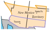
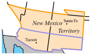
thumb|right|240px|Proposed boundaries for State of New Mexico, 1850The Territory of New Mexico was an organized incorporated territory of the United States that existed from September 9, 1850, until January 6, 1912, when the final extent of the territory was admitted to the Union as the State of...
, which included the areas which became the modern U.S. states of New Mexico
New Mexico
New Mexico is a state located in the southwest and western regions of the United States. New Mexico is also usually considered one of the Mountain States. With a population density of 16 per square mile, New Mexico is the sixth-most sparsely inhabited U.S...
and Arizona
Arizona
Arizona ; is a state located in the southwestern region of the United States. It is also part of the western United States and the mountain west. The capital and largest city is Phoenix...
as well as the southern part of Nevada
Nevada
Nevada is a state in the western, mountain west, and southwestern regions of the United States. With an area of and a population of about 2.7 million, it is the 7th-largest and 35th-most populous state. Over two-thirds of Nevada's people live in the Las Vegas metropolitan area, which contains its...
, played a role in the Trans-Mississippi Theater
Trans-Mississippi Theater of the American Civil War
The Trans-Mississippi Theater of the American Civil War was the major military and naval operations west of the Mississippi River. The area excluded the states and territories bordering the Pacific Ocean, which formed the Pacific Coast Theater of the American Civil War.The campaign classification...
of the American Civil War
American Civil War
The American Civil War was a civil war fought in the United States of America. In response to the election of Abraham Lincoln as President of the United States, 11 southern slave states declared their secession from the United States and formed the Confederate States of America ; the other 25...
. Both Confederate
Confederate States of America
The Confederate States of America was a government set up from 1861 to 1865 by 11 Southern slave states of the United States of America that had declared their secession from the U.S...
and Union
Union (American Civil War)
During the American Civil War, the Union was a name used to refer to the federal government of the United States, which was supported by the twenty free states and five border slave states. It was opposed by 11 southern slave states that had declared a secession to join together to form the...
governments claimed ownership and territorial rights over it. In 1861 the Confederacy claimed the southern tract as its own Arizona Territory and waged the ambitious New Mexico Campaign
New Mexico Campaign
The New Mexico Campaign was a military operation of the American Civil War from February to April 1862 in which Confederate Brigadier General Henry Hopkins Sibley invaded the northern New Mexico Territory in an attempt to gain control of the Southwest, including the gold fields of Colorado and the...
in an attempt to control the American Southwest and open up access to Union California
California
California is a state located on the West Coast of the United States. It is by far the most populous U.S. state, and the third-largest by land area...
. Confederate power in the New Mexico Territory was effectively broken after the Battle of Glorieta Pass
Battle of Glorieta Pass
The Battle of Glorieta Pass, fought from March 26 to 28, 1862 in northern New Mexico Territory, was the decisive battle of the New Mexico Campaign during the American Civil War. Dubbed the "Gettysburg of the West" by some historians, it was intended as the killer blow by Confederate forces to break...
in 1862. However, the territorial government continued to operate out of Texas, and Confederate troops marched under the Arizona flag until the end of the war. Additionally, over 8,000 troops from New Mexico Territory served the Union.
Prelude to war
After the expansion of the New Mexico Territory in 1853 by the Gadsden PurchaseGadsden Purchase
The Gadsden Purchase is a region of present-day southern Arizona and southwestern New Mexico that was purchased by the United States in a treaty signed by James Gadsden, the American ambassador to Mexico at the time, on December 30, 1853. It was then ratified, with changes, by the U.S...
, proposals for a division of the territory and the organization of a separate Territory of Arizona in the southern half of the territory were advanced as early as 1856. The first proposals for the Arizona Territory were not based on the current east-west scheme, but rather a north-south division. The proposals arose from concerns about the effectiveness of the territorial government in Santa Fe
Santa Fe, New Mexico
Santa Fe is the capital of the U.S. state of New Mexico. It is the fourth-largest city in the state and is the seat of . Santa Fe had a population of 67,947 in the 2010 census...
to administer the newly-acquired southern portions of the territory.
The first proposal dates from a conference held in Tucson
Tucson, Arizona
Tucson is a city in and the county seat of Pima County, Arizona, United States. The city is located 118 miles southeast of Phoenix and 60 miles north of the U.S.-Mexico border. The 2010 United States Census puts the city's population at 520,116 with a metropolitan area population at 1,020,200...
that convened on August 29, 1856. The conference issued a petition to the U.S. Congress, signed by 256 people, requesting organization of the territory and elected Nathan P. Cooke as the territorial delegate to Congress. In January 1857, the bill for the organization of the territory was introduced into the United States House of Representatives
United States House of Representatives
The United States House of Representatives is one of the two Houses of the United States Congress, the bicameral legislature which also includes the Senate.The composition and powers of the House are established in Article One of the Constitution...
, but the proposal was defeated on the grounds that the population of the proposed territory was yet too small. Later a similar proposal was defeated in the Senate
United States Senate
The United States Senate is the upper house of the bicameral legislature of the United States, and together with the United States House of Representatives comprises the United States Congress. The composition and powers of the Senate are established in Article One of the U.S. Constitution. Each...
. The proposal for creation of the territory was controversial in part because of the perception that the New Mexico Territory was under the influence of southern sympathizers who were highly desirous of expanding slavery
Slavery
Slavery is a system under which people are treated as property to be bought and sold, and are forced to work. Slaves can be held against their will from the time of their capture, purchase or birth, and deprived of the right to leave, to refuse to work, or to demand compensation...
into the southwest.
In February 1858, the New Mexico territorial legislature adopted a resolution in favor of the creation of the Arizona territory, but with a north-south border along the 109th meridian
109th meridian west
The meridian 109° west of Greenwich is a line of longitude that extends from the North Pole across the Arctic Ocean, North America, the Pacific Ocean, the Southern Ocean, and Antarctica to the South Pole....
, with the additional stipulation that all the Indians of New Mexico would be removed to northern Arizona. In April 1860, impatient for Congress to act, a convention of thirty-one delegates met in Tucson and adopted a constitution for a provisional territorial government of the area south of 34 degrees north
34th parallel north
The 34th parallel north is a circle of latitude that is 34 degrees north of the Earth's equatorial plane. It crosses Africa, the Mediterranean Sea, Asia, the Pacific Ocean, North America and the Atlantic Ocean....
. The delegates elected Lewis Owings
Lewis Owings
Dr. Lewis Sumpter Owings was a medical doctor and politician in the New Mexico and Arizona territories. He was chosen twice for the role of Provisional Governor for the territory of Arizona by conventions seeking to organize the territory-by both pre-Civil War Union and Confederate...
as provisional governor.
However, due to the small number of inhabitants in the proposed territory, the U.S. Congress continued to refuse to recognize any proceedings from any of the conventions being held in this area. Additionally, making matters worse, on March 2 of 1861 the U.S. Government formally revoked a contract with the Butterfield Overland Stagecoach Company
Butterfield Overland Mail
The Butterfield Overland Mail Trail was a stagecoach route in the United States, operating from 1857 to 1861. It was a conduit for the U.S. mail from two eastern termini, Memphis, Tennessee and St. Louis, Missouri, meeting Fort Smith, Arkansas, and continuing through Indian Territory, New Mexico,...
which was being used to support delivery of United States mail on the overland route which ran from San Antonio, Texas
San Antonio, Texas
San Antonio is the seventh-largest city in the United States of America and the second-largest city within the state of Texas, with a population of 1.33 million. Located in the American Southwest and the south–central part of Texas, the city serves as the seat of Bexar County. In 2011,...
through El Paso, Texas, Mesilla, Tucson and on to California
California
California is a state located on the West Coast of the United States. It is by far the most populous U.S. state, and the third-largest by land area...
. The loss of this key communications link with the rest of the United States angered the settlers in the Arizona region, just as the deep South states were seceding from the Union.
Civil War
Politics
At the outbreak of the Civil War, sentiment in the territory was in favor of the Confederacy. A territorial secessionSecession
Secession is the act of withdrawing from an organization, union, or especially a political entity. Threats of secession also can be a strategy for achieving more limited goals.-Secession theory:...
convention was held at Mesilla on March 16, 1861 that adopted an ordinance of secession, and called on the citizens in western Arizona to "join us in this movement". Subsequently a second convention was held in Tucson on March 28, 1861, chaired by Mark Aldrich, who had been Tucson's first mayor. The Tucson convention ratified the Mesilla convention, and provisional officers were elected for the newly established Provisional Confederate Territory of Arizona
Arizona Territory (CSA)
The Territory of Arizona was a territory claimed by the Confederate States of America during the American Civil War, between 1861 and 1865. It consisted of the portion of the New Mexico Territory south of the 34th parallel north including parts of the modern states of New Mexico and Arizona. Its...
with Dr. Lewis Owings as its governor, and Granville H. Oury as its first delegate to the Confederate States Congress
Congress of the Confederate States
The Congress of the Confederate States was the legislative body of the Confederate States of America, existing during the American Civil War between 1861 and 1865...
, who immediately began petitioning for admission.
Early in war, the Confederacy regarded the territory as a valuable route for possible access to the Pacific Ocean
Pacific Ocean
The Pacific Ocean is the largest of the Earth's oceanic divisions. It extends from the Arctic in the north to the Southern Ocean in the south, bounded by Asia and Australia in the west, and the Americas in the east.At 165.2 million square kilometres in area, this largest division of the World...
, with the specific intention of capturing California
California
California is a state located on the West Coast of the United States. It is by far the most populous U.S. state, and the third-largest by land area...
. In July 1861, a small Confederate force of Texans, under the command of Lieutenant Colonel John R. Baylor, captured Mesilla
Mesilla, New Mexico
Mesilla is a town in Doña Ana County, New Mexico, United States. The population was 2,180 at the 2000 census...
in the eastern part of the territory. After the fort was abandoned by the Union garrison, Baylor's force cut off the fleeing Union troops and forced them to surrender. On August 1, Baylor issued a "The Proclamation to the People of the Territory of Arizona", taking possession of the territory for the Confederacy, with Mesilla as the capital and himself as the governor.
Baylor's subsequent dismantling of the existing Union forts in the territory left the white settlers at the mercy of the Apache, who quickly gained control of the area and forced many of the white settlers to seek refuge in Tucson. However, the people of Arizona remained firm in their support of Baylor, and held another convention on August 28, 1861 in Tucson, ratifying Baylor's proclamation. Once again, Granville Oury was re-elected as a congressman to the Confederate States Congress. Governor Baylor approved the proceedings, and Delegate Granville H. Oury
Oury
Oury is a town in the Oury Department of Balé Province in southern Burkina Faso. It is the capital of the Oury Department and the town has a total population of 3,908.-External links:*...
was sent off to Richmond, Virginia on October 1, 1861.
Delegate Oury was not initially seated in the congress, but met with C.S. leaders as well as President Jefferson Davis. Texas Congressman John Reagan introduced a bill on November 22, 1861 to formally create the Territory of Arizona. After two months of debate, the legislation passed on January 13, 1862, and the territory was officially created by proclamation of President Jefferson Davis
Jefferson Davis
Jefferson Finis Davis , also known as Jeff Davis, was an American statesman and leader of the Confederacy during the American Civil War, serving as President for its entire history. He was born in Kentucky to Samuel and Jane Davis...
on February 14, with this proclamation:
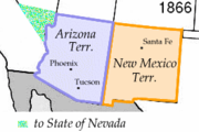
Exactly fifty years later, on the same date, Arizona was made a state in 1912.
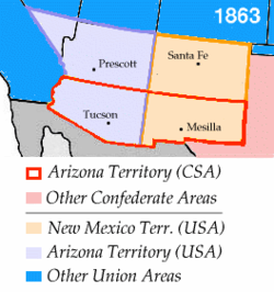
The following month, in March 1862, the U.S. House of Representatives, now devoid of the southern delegates and controlled by Republicans, passed a bill to create the United States Arizona Territory using the north-south border of the 107th meridian
107th meridian west
The meridian 107° west of Greenwich is a line of longitude that extends from the North Pole across the Arctic Ocean, North America, the Pacific Ocean, the Southern Ocean, and Antarctica to the South Pole....
. The use of a north-south border rather than an east-west one had the effect of denying a de facto ratification of the Confederate Arizona Territory. The house bill stipulated that Tucson was to be capital. It also stipulated that slavery was to be abolished in the new territory. The Arizona Organic Act
Arizona Organic Act
The Arizona Organic Act was a United States federal law introduced as H.R. 357 in the 2d session of the 37th Congress on March 12, 1862, by Rep. James M. Ashley of Ohio. The Act provided for the creation of the Arizona Territory by the division of the New Mexico Territory into two territories,...
passed the Senate in February 1863 without the Tucson-as-capital stipulation, and was signed into law by President Abraham Lincoln
Abraham Lincoln
Abraham Lincoln was the 16th President of the United States, serving from March 1861 until his assassination in April 1865. He successfully led his country through a great constitutional, military and moral crisis – the American Civil War – preserving the Union, while ending slavery, and...
on February 24, the date of the official organization of the US Arizona Territory. The first capital was at Fort Whipple, followed by Prescott
Prescott, Arizona
Prescott is a city in Yavapai County, Arizona, USA. It was designated "Arizona's Christmas City" by Arizona Governor Rose Mofford in the late 1980s....
, in the northern Union-controlled area.
At the start of the Civil War, the territorial governor was Abraham Rencher; although a Democrat from North Carolina, he refused to support succession, and called out the territorial militia to counteract the Confederate invasion of July 1861. That month he was replaced by Henry Connelly, a native of New Mexico who would serve as governor for the remainder of the war. Under his leadership, the slavery laws of the territory were repealed and the Indian tribes of the territory were moved onto reservations.
Military actions
When Federal troops left Arizona early in 1861, the territory was left open to ApacheApache
Apache is the collective term for several culturally related groups of Native Americans in the United States originally from the Southwest United States. These indigenous peoples of North America speak a Southern Athabaskan language, which is related linguistically to the languages of Athabaskan...
attack. Mangas Coloradas
Mangas Coloradas
Mangas Coloradas, or Dasoda-hae , was an Apache tribal chief and a member of the Eastern Chiricahua nation, whose homeland stretched west from the Rio Grande to include most of what is present-day southwestern New Mexico...
and Cochise
Cochise
Cochise was a chief of the Chokonen band of the Chiricahua Apache and the leader of an uprising that began in 1861. Cochise County, Arizona is named after him.-Biography:...
led a series of raids on white civilians that left dozens dead and spread fear and terror across the territory. Both the Confederates and the Federal government attempted to control the Apaches. The remaining Union troops in the New Mexico Territory were concentrated in forts along and near the Rio Grande; the commander of the Union Department of New Mexico
Department of New Mexico
The Department of New Mexico was a department of the United States Army during the mid-19th century. At first a part of the Department of the West, it was created as an independent department following the breakup of that Division into various departments during the Civil War...
, Colonel E. R. S. Canby, started raising regiments of New Mexico volunteers and militia to replace the regular army units which were ordered east.
Capt. Sherod Hunter
Sherod Hunter
Sherod Hunter was the commander of the Confederate unit operating against Union Army forces in present day Arizona during the American Civil War...
at the head of the Confederate Arizona Rangers
Company A, Arizona Rangers
Company A, Arizona Rangers was one of the Confederate military units raised in the Confederate Arizona Territory.- Origin of the Arizona Rangers :...
, occupied southern Arizona during the spring of 1862. He bore orders from Governor Baylor to lure the Apaches into Tucson for peace talks and exterminate the adults. Hunter's frontiersmen spent most of their time expelling Union
Union (American Civil War)
During the American Civil War, the Union was a name used to refer to the federal government of the United States, which was supported by the twenty free states and five border slave states. It was opposed by 11 southern slave states that had declared a secession to join together to form the...
supporters and skirmishing with Federal troops
Union Army
The Union Army was the land force that fought for the Union during the American Civil War. It was also known as the Federal Army, the U.S. Army, the Northern Army and the National Army...
, so the order was never enforced. A detachment of Hunter's force traveled along the Overland Mail route and destroyed chaches of hay to prevent their use by Union forces; it traveled to within eighty miles of Fort Yuma.
In April 1862, a small party of Confederates moving northwest from Tucson met a Union cavalry patrol near Stanwix Station
Stanwix Station
Stanwix Station, in western Arizona, was a stop on the Butterfield Overland Mail Stagecoach line built in the later 1850s near the Gila River about east of Yuma, Arizona. Originally the station was called Flap Jack Ranch later Grinnell's Ranch or Grinnell's Station...
. The skirmish that followed, in which one Union cavalryman was wounded, was the westernmost engagement of the Civil War. The goal of expanding Confederate influence into southern California and to the Pacific Ocean
Pacific Ocean
The Pacific Ocean is the largest of the Earth's oceanic divisions. It extends from the Arctic in the north to the Southern Ocean in the south, bounded by Asia and Australia in the west, and the Americas in the east.At 165.2 million square kilometres in area, this largest division of the World...
was never realized. Following the Battle of Picacho Pass
Battle of Picacho Pass
The Battle of Picacho Pass or the Battle of Picacho Peak was an engagement of the American Civil War on April 15, 1862. The action occurred all around Picacho Peak, northwest of Tucson, Arizona...
at Picacho Peak
Picacho Peak State Park
Picacho Peak State Park is a state park of Arizona, USA, surrounding Picacho Peak. The park is located between Casa Grande and Tucson near Interstate 10 in Pinal County. Its centerpiece spire is visible from downtown Tucson, a distance of . The summit rises to above mean sea level...
the lead detachment of Col. James H. Carleton
James Henry Carleton
James Henry Carleton was an officer in the Union army during the American Civil War. Carleton is most well known as an Indian fighter in the southwestern United States.-Biography:...
's California Column
California Column
The California Column, a force of Union volunteers, marched from April to August 1862 over 900 miles from California, across the southern New Mexico Territory to the Rio Grande and then into western Texas during the American Civil War. At the time, this was the longest trek through desert terrain...
, drove the Confederates out of Tucson, and advanced on the Mesilla the capital of Confederate Arizona and by July the Confederates had retreated to Texas
Texas
Texas is the second largest U.S. state by both area and population, and the largest state by area in the contiguous United States.The name, based on the Caddo word "Tejas" meaning "friends" or "allies", was applied by the Spanish to the Caddo themselves and to the region of their settlement in...
. Carleton's troops later fought the Battle of Apache Pass
Battle of Apache Pass
The Battle of Apache Pass was fought in 1862 at Apache Pass, Arizona in the United States, between Apache warriors and the Union volunteers of the California Column as it marched from California to capture Confederate Arizona and to reinforce New Mexico's Union army...
after being ambushed by Cochise and Mangas Coloradas. Even though the column withstood the Apaches and established Fort Bowie
Fort Bowie
Fort Bowie was a 19th century outpost of the United States Army located in southeastern Arizona near the present day town of Willcox, Arizona.Fort Bowie was established in 1862 after a series of engagements between the U.S. Military and the Chiricahua Apaches. The most violent of which was the...
to secure the pass
Mountain pass
A mountain pass is a route through a mountain range or over a ridge. If following the lowest possible route, a pass is locally the highest point on that route...
, the Californians and the Apache would continue fighting throughout the War and beyond.
As the main route to California
California
California is a state located on the West Coast of the United States. It is by far the most populous U.S. state, and the third-largest by land area...
, the New Mexico Territory
New Mexico Territory
thumb|right|240px|Proposed boundaries for State of New Mexico, 1850The Territory of New Mexico was an organized incorporated territory of the United States that existed from September 9, 1850, until January 6, 1912, when the final extent of the territory was admitted to the Union as the State of...
was disputed territory during the American Civil War
American Civil War
The American Civil War was a civil war fought in the United States of America. In response to the election of Abraham Lincoln as President of the United States, 11 southern slave states declared their secession from the United States and formed the Confederate States of America ; the other 25...
, resulting in settlers in the region carved out by the Gadsden Purchase
Gadsden Purchase
The Gadsden Purchase is a region of present-day southern Arizona and southwestern New Mexico that was purchased by the United States in a treaty signed by James Gadsden, the American ambassador to Mexico at the time, on December 30, 1853. It was then ratified, with changes, by the U.S...
willingly joining the Confederate States of America
Confederate States of America
The Confederate States of America was a government set up from 1861 to 1865 by 11 Southern slave states of the United States of America that had declared their secession from the U.S...
, while much of the rest of the present day state of New Mexico
New Mexico
New Mexico is a state located in the southwest and western regions of the United States. New Mexico is also usually considered one of the Mountain States. With a population density of 16 per square mile, New Mexico is the sixth-most sparsely inhabited U.S...
remained loyal to the Union
Union (American Civil War)
During the American Civil War, the Union was a name used to refer to the federal government of the United States, which was supported by the twenty free states and five border slave states. It was opposed by 11 southern slave states that had declared a secession to join together to form the...
. A significant Confederate push to seize the territory resulted in the New Mexico Campaign
New Mexico Campaign
The New Mexico Campaign was a military operation of the American Civil War from February to April 1862 in which Confederate Brigadier General Henry Hopkins Sibley invaded the northern New Mexico Territory in an attempt to gain control of the Southwest, including the gold fields of Colorado and the...
from February to April 1862. Confederate troops
Confederate States Army
The Confederate States Army was the army of the Confederate States of America while the Confederacy existed during the American Civil War. On February 8, 1861, delegates from the seven Deep South states which had already declared their secession from the United States of America adopted the...
from Texas
Texas
Texas is the second largest U.S. state by both area and population, and the largest state by area in the contiguous United States.The name, based on the Caddo word "Tejas" meaning "friends" or "allies", was applied by the Spanish to the Caddo themselves and to the region of their settlement in...
briefly occupied southern New Mexico Territory
New Mexico Territory
thumb|right|240px|Proposed boundaries for State of New Mexico, 1850The Territory of New Mexico was an organized incorporated territory of the United States that existed from September 9, 1850, until January 6, 1912, when the final extent of the territory was admitted to the Union as the State of...
. Union troops
Union Army
The Union Army was the land force that fought for the Union during the American Civil War. It was also known as the Federal Army, the U.S. Army, the Northern Army and the National Army...
re-captured the territory in early 1862. As the war lengthened and Union troops were withdrawn to fight elsewhere, famed explorer and frontiersman Kit Carson
Kit Carson
Christopher Houston "Kit" Carson was an American frontiersman and Indian fighter. Carson left home in rural present-day Missouri at age 16 and became a Mountain man and trapper in the West. Carson explored the west to California, and north through the Rocky Mountains. He lived among and married...
helped organize and command the 1st New Mexico Infantry, a militia
Militia
The term militia is commonly used today to refer to a military force composed of ordinary citizens to provide defense, emergency law enforcement, or paramilitary service, in times of emergency without being paid a regular salary or committed to a fixed term of service. It is a polyseme with...
unit, to engage in campaigns against the Apache
Apache
Apache is the collective term for several culturally related groups of Native Americans in the United States originally from the Southwest United States. These indigenous peoples of North America speak a Southern Athabaskan language, which is related linguistically to the languages of Athabaskan...
, Navajo
Navajo Nation
The Navajo Nation is a semi-autonomous Native American-governed territory covering , occupying all of northeastern Arizona, the southeastern portion of Utah, and northwestern New Mexico...
, and Comanche
Comanche
The Comanche are a Native American ethnic group whose historic range consisted of present-day eastern New Mexico, southern Colorado, northeastern Arizona, southern Kansas, all of Oklahoma, and most of northwest Texas. Historically, the Comanches were hunter-gatherers, with a typical Plains Indian...
in New Mexico and Texas, as well as participating in the earlier Battle of Valverde
Battle of Valverde
The Battle of Valverde, or the Battle of Valverde Ford from February 20 to February 21, 1862, was fought near the town of Valverde at a ford of Valverde Creek in Confederate Arizona, in what is today the state of New Mexico. It was a major Confederate success in the New Mexico Campaign of the...
against the Confederates. Confederate troops withdrew after the Battle of Glorieta Pass
Battle of Glorieta Pass
The Battle of Glorieta Pass, fought from March 26 to 28, 1862 in northern New Mexico Territory, was the decisive battle of the New Mexico Campaign during the American Civil War. Dubbed the "Gettysburg of the West" by some historians, it was intended as the killer blow by Confederate forces to break...
, because a detachment of the 1st Colorado Infantry under Major John M. Chivington had burned their supply train. Despite the Union
Union (American Civil War)
During the American Civil War, the Union was a name used to refer to the federal government of the United States, which was supported by the twenty free states and five border slave states. It was opposed by 11 southern slave states that had declared a secession to join together to form the...
regulars, 1st Colorado Infantry ("The Pikes Peakers"), and New Mexican Volunteers being defeated on the battlefield, they won the campaign; the battle was later dubbed as the "Gettysburg of the West".
Confederate Arizona Territory
Arizona Territory (CSA)
The Territory of Arizona was a territory claimed by the Confederate States of America during the American Civil War, between 1861 and 1865. It consisted of the portion of the New Mexico Territory south of the 34th parallel north including parts of the modern states of New Mexico and Arizona. Its...
, which split off from New Mexico Territory in 1861, was the first U.S. incarnation of Arizona
Arizona
Arizona ; is a state located in the southwestern region of the United States. It is also part of the western United States and the mountain west. The capital and largest city is Phoenix...
which would come into existence as Arizona Territory
Arizona Territory
The Territory of Arizona was an organized incorporated territory of the United States that existed from February 24, 1863 until February 14, 1912, when it was admitted to the Union as the 48th state....
in 1863. Confederate Arizona was created by capturing the southern tier of the Union's New Mexico Territory, while the boundary established in 1863 created an Arizona on the west separated from New Mexico on the east.
See also
- Independent Companies, New Mexico Volunteer Militia InfantryIndependent Companies, New Mexico Volunteer Militia InfantryThe Independent Companies of New Mexico Militia were units of infantry raised within the New Mexico Territory to serve a three-month term of service for the Union Army during the American Civil War, from November 1861 to February 1862...
- List of New Mexico Territory Civil War units