

National Tourist Routes in Norway
Encyclopedia
National Tourist Routes in Norway is a Norwegian Public Roads Administration
designation for road routes that offer a picturesque trip and have been upgraded with tourist-friendly infrastructure, such as rest stops and viewpoints. Eighteen routes have been selected, of which six have been completed and are signposted as such. The routes cover 1850 kilometres (1,149.5 mi) and are located along the West Coast, in Northern Norway and in the mountains of Southern Norway. The routes have been selected based on their unique natural surroundings, status as alternatives to main roads, and availability of viewpoints and tourist services. In combination with the routes, the authorities have coordinated the establishment of accommodation, cultural activities, dining, sale of local arts and crafts, and natural experiences.
The project started in 1994 with projects on Sognefjellsvegen
, Gamle Strynefjellsveg, Hardanger and the Helgeland
Coast. In 1997, these were officially designated National Tourist Routes, and the following year Parliament decided to expand the project. Municipalities were asked to nominate roads, resulting in 52 nominees covering 8000 kilometres (4,971 mi). In 2004, eighteen routes were selected, with the goal of completing the necessary upgrades and officially opening them as National Tourist Routes by 2015. The upgrades are estimated to cost 800 million Norwegian krone
. The upgrades include building resting places, parking lots, viewpoints, and clearing vegetation. The stops are seen as art projects that use design to enhance the experience. While most of the architecture has been designed by young Norwegians, Louise Bourgeois
and Peter Zumthor
have designed stops in Varanger and Ryfylke.
Two routes constitute part of the International E-road network
, E10
through Lofoten
and E75
through Varanger
. Mountain pass
roads, such as Sognefjellsvegen, Valdresflye and Trollstigen
, are closed during winter. Both sections of the Helgeland Coast Route have two ferries in them, while there is one ferry on Geiranger–Trollstigen and three each on the routes through Ryfylke
and Hardanger
. The Andøya and Senja routes are connected via the Andenes–Gryllefjord Ferry
.
Norwegian Public Roads Administration
The Norwegian Public Roads Administration is a Norwegian government agency responsible for the state and county public roads in the country. This includes planning, construction and operation of the state and county road networks, driver training and licensing, vehicle inspection and subsidies to...
designation for road routes that offer a picturesque trip and have been upgraded with tourist-friendly infrastructure, such as rest stops and viewpoints. Eighteen routes have been selected, of which six have been completed and are signposted as such. The routes cover 1850 kilometres (1,149.5 mi) and are located along the West Coast, in Northern Norway and in the mountains of Southern Norway. The routes have been selected based on their unique natural surroundings, status as alternatives to main roads, and availability of viewpoints and tourist services. In combination with the routes, the authorities have coordinated the establishment of accommodation, cultural activities, dining, sale of local arts and crafts, and natural experiences.
The project started in 1994 with projects on Sognefjellsvegen
Sognefjellsvegen
The Sognefjellsvegen or Sognefjellsveien is the highest mountain pass road in Northern Europe. It is located in Oppland and Sogn og Fjordane counties in Norway. It is a national tourist road and starts in the village of Lom in the municipality of Lom, it then travels over the Sognefjell mountain...
, Gamle Strynefjellsveg, Hardanger and the Helgeland
Helgeland
Helgeland is the most southerly district in Northern Norway. Generally speaking, Helgeland refers to the part of Nordland county that is located south of the Arctic Circle. The district covers an area of about , with nearly 79,000 inhabitants...
Coast. In 1997, these were officially designated National Tourist Routes, and the following year Parliament decided to expand the project. Municipalities were asked to nominate roads, resulting in 52 nominees covering 8000 kilometres (4,971 mi). In 2004, eighteen routes were selected, with the goal of completing the necessary upgrades and officially opening them as National Tourist Routes by 2015. The upgrades are estimated to cost 800 million Norwegian krone
Norwegian krone
The krone is the currency of Norway and its dependent territories. The plural form is kroner . It is subdivided into 100 øre. The ISO 4217 code is NOK, although the common local abbreviation is kr. The name translates into English as "crown"...
. The upgrades include building resting places, parking lots, viewpoints, and clearing vegetation. The stops are seen as art projects that use design to enhance the experience. While most of the architecture has been designed by young Norwegians, Louise Bourgeois
Louise Bourgeois
Louise Joséphine Bourgeois , was a renowned French-American artist and sculptor, best known for her contributions to both modern and contemporary art, and for her spider structures, titled Maman, which resulted in her being nicknamed the Spiderwoman...
and Peter Zumthor
Peter Zumthor
Peter Zumthor is a Swiss architect and winner of the 2009 Pritzker Prize.-Early life:Zumthor was born in Basel, the son of a cabinet-maker...
have designed stops in Varanger and Ryfylke.
Two routes constitute part of the International E-road network
International E-road network
The international E-road network is a numbering system for roads in Europe developed by the United Nations Economic Commission for Europe . The network is numbered from E 1 up and its roads cross national borders...
, E10
European route E10
European route E 10 is a road part of the International E-road network. It begins in Å, Norway and ends in Luleå, Sweden. The road is about 850 km in length...
through Lofoten
Lofoten
Lofoten is an archipelago and a traditional district in the county of Nordland, Norway. Though lying within the Arctic Circle, the archipelago experiences one of the world's largest elevated temperature anomalies relative to its high latitude.-Etymology:...
and E75
European route E75
European route E 75 is part of the International E-road network, which is a series of main roads in Europe.The E 75 starts from Vardø, Norway in the Barents Sea and runs south through Finland, Poland, Czech Republic, Slovakia, Hungary, Serbia and Republic of Macedonia to Sitia, Greece on...
through Varanger
Varanger Peninsula
Varanger Peninsula is a peninsula in Finnmark, north-eastern Norway, by the Barents Sea. The peninsula has the Tanafjord to the west, the Varangerfjord to the south and the Barents Sea to the north and east. Vadsø, Båtsfjord, Berlevåg, Vardø and Unjárga - Nesseby are the municipalities sharing the...
. Mountain pass
Mountain pass
A mountain pass is a route through a mountain range or over a ridge. If following the lowest possible route, a pass is locally the highest point on that route...
roads, such as Sognefjellsvegen, Valdresflye and Trollstigen
Trollstigen
Trollstigen is a mountain road in Rauma, Norway, part of Norwegian National Road 63 connecting Åndalsnes in Rauma and Valldal in Norddal. It is a popular tourist attraction due to its steep incline of 9% and eleven hairpin bends up a steep mountain side...
, are closed during winter. Both sections of the Helgeland Coast Route have two ferries in them, while there is one ferry on Geiranger–Trollstigen and three each on the routes through Ryfylke
Ryfylke
Ryfylke is a traditional district in Norway, located northeast of Stavanger and east of Haugesund. In the east it borders Setesdal and Sirdal.Ryfylke comprises the contemporary municipalities of Sauda, Suldal, Finnøy, Hjelmeland, Forsand, Strand, Kvitsøy and Rennesøy...
and Hardanger
Hardanger
Hardanger is a traditional district in the western part of Norway, dominated by the Hardangerfjord. It consists of the municipalities of Odda, Ullensvang, Eidfjord, Ulvik, Granvin, Kvam and Jondal, and is located inside the county of Hordaland....
. The Andøya and Senja routes are connected via the Andenes–Gryllefjord Ferry
Andenes–Gryllefjord Ferry
Andenes–Gryllefjord Ferry is a automotive ferry service connecting the islands of Andøya and Senja in Norway. Operated by Senjafergene, the crossing between Andenes in Andøy and Gryllefjord in Torsken takes 1 hour and 40 minutes. The services is only operated from late May to late August, and has...
.
List
The following is a list of National Tourist Routes in Norway that have officially opened or have been approved and are under upgrade. It contains an image, the name of the road, the start and finish locations of the route, the county or counties the route runs through, the road numbers the route follows, the length of the road and a description.| Image | Name | | Route | County(s) | Road(s) | Length | | Description | Refs |
|---|---|---|---|---|---|---|---|
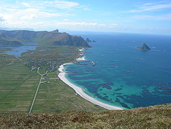 |
Andøya | Åkneskrysset Åknes Åknes is a hamlet in Andøy, Norway.... –Andenes Andenes is a town and former municipality in Vesterålen district in Nordland county, Norway.Andenes was separated from Dverberg January 1, 1924. It was merged with Dverberg and Bjørnskinn to create the new municipality of Andøy January 1, 1964.... |
Nordland Nordland is a county in Norway in the North Norway region, bordering Troms in the north, Nord-Trøndelag in the south, Norrbottens län in Sweden to the east, Västerbottens län to the southeast, and the Atlantic Ocean to the west. The county was formerly known as Nordlandene amt. The county administration is... |
974, 976, 82 Norwegian County Road 82 County Road 82 runs between Fiskebøl and Andenes in Nordland, Norway. The road runs through Hadsel, Sortland and Andøy. At Fiskebøl, the road intersects with E10 before crossing the Fiskebøl–Melbu Ferry. Bridges on the road include Andøy Bridge, Hadsel Bridge, Sortland Bridge, and Børøy Bridge... |
The road runs along the west coast of Andøya Andøya Andøya is the northernmost island in the archipelago of Vesterålen. Andøya is located in the Andøy municipality in Nordland county, Norway.The island has an area of 489 km², making it the tenth largest island in Norway. The island is connected to the neighboring island of Hinnøya using the... , the northernmost island of the Vesterålen Vesterålen Vesterålen is a district and archipelago in Nordland, Norway, just north of Lofoten.-The name:The Norse forms of the name were Vestráll and Vestrálar . The first element is vestr n west, the last element is áll m ' sound, strait'... archipelago, featuring fishing hamlets between the unsheltered white beaches. The islands has Norway's largest marshes, and whales, seals and bird rocks can be spotted in the Norwegian Sea Norwegian Sea The Norwegian Sea is a marginal sea in the North Atlantic Ocean, northwest of Norway. It is located between the North Sea and the Greenland Sea and adjoins the North Atlantic Ocean to the west and the Barents Sea to the northeast. In the southwest, it is separated from the Atlantic Ocean by a... . The route connects to National Tourist Route Senja by ferry. |
||
| Atlantic Ocean Road | Kårvåg Kårvåg Kårvåg is a village in the municipality of Averøy in Møre og Romsdal county, Norway. It is located on the west side of the island of Averøya near the east end of the Atlanterhavsveien. The village of Kornstad lies to the south and Langøy is to the north. The village has a population of 275.... –Bud Bud, Norway Bud is a fishing village and former municipality in the present-day municipality of Fræna in Møre og Romsdal county in western Norway. The village is located on the Romsdal peninsula along the Atlanterhavsveien, west of the village of Hustad, north of the village of Tornes, and east of the... |
Møre og Romsdal Møre og Romsdal is a county in the northernmost part of Western Norway. It borders the counties of Sør-Trøndelag, Oppland and Sogn og Fjordane. The county administration is located in Molde, while Ålesund is the largest city.-The name:... |
64 Norwegian County Road 64 County Road 64 is a two-lane highway which runs between Kristiansund and Åndalsnes in Møre og Romsdal, Norway. It branches from National Road 70 in Kristiansund, runs through the Atlantic Ocean Tunnel, through the island of Averøy, and across the Atlantic Ocean Road to Eide... , 242, 663, 235, 238 |
From Kårvåg to Vevang Vevang Vevang is a village in Eide, Norway. It is located on the western end of the Atlantic Ocean Road.... , the Atlantic Ocean Road is built on several small unsheltered islands and skerries Skerry A skerry is a small rocky island, usually defined to be too small for habitation. It may simply be a rocky reef. A skerry can also be called a low sea stack.... , and is spanned by eight bridges, several causeways and viaducts. The National Tourist Route continues along the coast of Hustadvika Hustadvika Hustadvika is a long section of coastline outside the municipality of Fræna in Romsdal, Møre og Romsdal county, Norway. It is located in the shipping route between Molde and Kristiansund. The area is shallow and is full of little islands and reefs... —infamous as a ship graveyard. |
|||
| Aurlandsfjellet | Aurlandsvangen Aurlandsvangen Aurlandsvangen is the administrative center of the municipality of Aurland in Sogn og Fjordane county, Norway. The village is located on the east side of the Aurlandsfjord where the Aurlandselvi river flows into the fjord. The village of Undredal and the famous Nærøyfjord are located just a few... –Lærdalsøyri Lærdalsøyri Lærdalsøyri is the administrative centre of the municipality of Lærdal in Sogn og Fjordane county, Norway. The village is located along the Lærdalselvi river where it empties into the Lærdalsfjord, a branch of the Sognefjord. The village is located about north of the east end of the Lærdal Tunnel... |
Sogn og Fjordane Sogn og Fjordane is a county in Norway, bordering Møre og Romsdal, Oppland, Buskerud, and Hordaland. The county administration is in the town of Hermansverk in Leikanger municipality while the largest town is Førde.... |
243 | The crossing of Aurlandsfjellet Aurlandsfjellet Aurlandsfjellet is a mountain between Aurland and Lærdal in Sogn og Fjordane, Norway. Sogn og Fjordane County Road 243 runs across the mountain, while the Lærdal Tunnel runs through it.... allows the route to bypasses the Lærdal Tunnel—the world's longest road tunnel. The barren mountain plateau offers views 600 m (1,968.5 ft) down on the Aurlandsfjord Aurlandsfjord Aurlandsfjord is a fjord in Aurland, Vik and Lærdal in Sogn og Fjordane, Norway. It is a branch of Sognefjord; after , the Nærøyfjord branches from it.... . |
|||
| Gamle Strynefjellsvegen | Grotli Grotli Grotli is a village in Skjåk, Norway. The village is abandoned except for a hotel and some cabins.... –Ospeli Ospeli Ospeli is an area in Stryn, Norway. At Ospeli, Sogn og Fjordane County Road 258 branches off from National Road 15, with the latter running through the Ospeli Tunnel.... |
Oppland Oppland is a county in Norway, bordering Sør-Trøndelag, Møre og Romsdal, Sogn og Fjordane, Buskerud, Akershus, Oslo and Hedmark. The county administration is in Lillehammer. Oppland is, together with Hedmark, one of the only two landlocked counties of Norway.... , Sogn og Fjordane Sogn og Fjordane is a county in Norway, bordering Møre og Romsdal, Oppland, Buskerud, and Hordaland. The county administration is in the town of Hermansverk in Leikanger municipality while the largest town is Førde.... |
258 | Opened in 1894, the road connects the mountain village of Skjåk Skjåk Skjåk is a municipality in Oppland county, Norway. It is part of the traditional region of Gudbrandsdal. The administrative centre of the municipality is the village of Bismo... and the fjord village of Stryn Stryn Stryn is a municipality in the county of Sogn og Fjordane, Norway. It is located in the traditional district of Nordfjord. The administrative center of the municipality is the village of Stryn which had a population of 2,177 in 2009. The municipality is located along the innermost part of the... . It passes round, glaciated forms in the east and steep, rugged typography in the west. Skiing is possible far into the summer and the road is not opened until June. |
|||
| Gaularfjellet | Balestrand Balestrand Balestrand is a municipality in the county of Sogn og Fjordane, Norway. It is located in the traditional district of Sogn. The administrative center is the village of Balestrand.... –Moskog Moskog Moskog is an area in Førde, Norway. At Moskog the concurrency of National Road 5 and E39 meets County Road 13.... |
Sogn og Fjordane Sogn og Fjordane is a county in Norway, bordering Møre og Romsdal, Oppland, Buskerud, and Hordaland. The county administration is in the town of Hermansverk in Leikanger municipality while the largest town is Førde.... |
13, 55 | The route over Gaularfjellet Gaularfjellet Gaularfjellet is a mountain area in the borders between Gaular, Balestrand and Førde in Sogn og Fjordane, Norway. National Road 13 crosses the mountain.... offers an alternative route between Sogn Sogn Sogn is a traditional district in Western Norway . It is located in the county of Sogn og Fjordane, surrounding the Sognefjord. Sogn consists of the municipalities of Aurland, Balestrand, Hyllestad, Høyanger, Gulen, Leikanger, Luster, Lærdal, Sogndal, Solund, Vik, and Årdal. The district covers ... and Sunnfjord Sunnfjord Sunnfjord is a traditional district in Western Norway located in Sogn og Fjordane county. It includes the municipalities of Askvoll, Fjaler, Flora, Førde, Gaular, Jølster, Naustdal, and the southernmost parts of Bremanger... . Starting at Sognefjord Sognefjord The Sognefjord is the largest fjord in Norway, and the second longest in the world. Located in Sogn og Fjordane county, it stretches inland to the small village of Skjolden... , it passes lakes, rapids and waterfalls, and varies between steep mountain climbs, clinging to fjord and running through sheltered valleys. |
|||
| Geiranger–Trollstigen | Langevatn Langvatnet (Skjåk) Langvatnet is a lake in Skjåk, Norway. It has an area of and is located at above mean sea level.... –Sogge Bridge Sogge Bridge Sogge Bridge is a truss bridge crossing Rauma in Rauma, Norway, carrying County Road 63. The intersection between E136 and 63 is located on the north side of the bridge. The first bridge was built in 1877, but was washed away in 1895 or 1986. A new, wooden bridge was then built in 1903 or 1904.... |
Møre og Romsdal Møre og Romsdal is a county in the northernmost part of Western Norway. It borders the counties of Sør-Trøndelag, Oppland and Sogn og Fjordane. The county administration is located in Molde, while Ålesund is the largest city.-The name:... |
63 | The route climbs the mountainside along Trollstigen Trollstigen Trollstigen is a mountain road in Rauma, Norway, part of Norwegian National Road 63 connecting Åndalsnes in Rauma and Valldal in Norddal. It is a popular tourist attraction due to its steep incline of 9% and eleven hairpin bends up a steep mountain side... with its hairpin bends before dropping down to Geirangerfjord Geirangerfjord The Geiranger Fjord is a fjord in the Sunnmøre region of Møre og Romsdal county in Norway. It is in the municipality of Stranda. It is a long branch of the Storfjord... , a World Heritage Site World Heritage Site A UNESCO World Heritage Site is a place that is listed by the UNESCO as of special cultural or physical significance... , and clinging to the fjordside until reaching Geiranger Geiranger Geiranger is a small tourist village in Sunnmøre in the municipality of Stranda in Møre og Romsdal county, in the western part of Norway. It lies at the head of the Geirangerfjord, which is a branch of the Storfjord. The nearest city is Ålesund... . |
|||
| Hardanger | Halne Halnefjorden Halnefjorden is a lake in the municipalities of Ulvik in Hordaland county and Nore og Uvdal in Buskerud county, Norway.... –Steinsdalsfossen Steinsdalsfossen Steinsdalsfossen is a waterfall 2 kilometers west of Norheimsund, Hardanger in western Norway.... , Jondal Jondal Jondal is a municipality in the county of Hordaland, Norway. Jondal was separated from Strandebarm in 1846.-Name:The Old Norse form of the name was Jónardalr. The first element is an old rivername Jón and the last element is dalr which means "valley" or "dale"... –Utne Utne Utne is a village in Ullensvang municipality in Hardanger, Norway. It is home to the Utne Hotel, Norway's oldest hotel in continuous operation, founded in 1722.... , Kinsarvik Kinsarvik Kinsarvik is a village, and former municipality, in the county of Hordaland, Norway.Kinsarvik was established as a municipality January 1, 1838 . Ullensvang used to be an annex to Kinsarvik - but in 1869 Ullensvang became the main parish, and Kinsarvik became an annex to Ullensvang... –Tyssedal Tyssedal Tyssedal is a village in Odda municipality in Norway with about 700 inhabitants and is situated 6 km north of Odda center. Tyssedal is located in a charming environment between fjords and mountains, in the fjord arm Sørfjorden and at the edge of the Hardangervidda mountain plateau.Tyssedal is... |
Hordaland Hordaland is a county in Norway, bordering Sogn og Fjordane, Buskerud, Telemark and Rogaland. Hordaland is the third largest county after Akershus and Oslo by population. The county administration is located in Bergen... |
7, 550, 13 Norwegian National Road 13 National Road 13 is a national road which runs from Sandnes to Balestrand. The route is long and runs north–south through Rogaland, Hordaland and Sogn og Fjordane, following a more inward path than E39. From Balestrand to Førde, the route continues as County Road 13. The route has three ferries.... |
The route consists of three sections in Hardanger Hardanger Hardanger is a traditional district in the western part of Norway, dominated by the Hardangerfjord. It consists of the municipalities of Odda, Ullensvang, Eidfjord, Ulvik, Granvin, Kvam and Jondal, and is located inside the county of Hordaland.... , which varies between fjordlandscape, moorlands, mountainsides and glaciers. Two prominent waterfalls include Vøringsfossen and Steindalsfossen. The region is the hallmark of Norwegian romantic nationalism Norwegian romantic nationalism Norwegian romantic nationalism was a movement in Norway between 1840 and 1867 in art, literature, and popular culture that emphasized the aesthetics of Norwegian nature and the uniqueness of the Norwegian national identity... with roadside sale of traditional handicrafts and fruit. |
|||
| Havøysund Norwegian County Road 889 County Road 889 is long and runs between Smørfjord and Havøysund in Finnmark, Norway. The road runs through Porsanger, Kvalsund and Måsøy. At Smørfjord, the road branches from E69. It crosses to Havøysund across the Havøysund Bridge. The section from Russelv to Havøysund is designated one of... |
Russelv–Havøysund Havøysund Havøysund is the administrative centre of the Måsøy municipality, Norway. Its population in 2006 was 1,125. Located on Havøya, but is connected to the mainland through the Havøysund Bridge.... |
Finnmark Finnmark or Finnmárku is a county in the extreme northeast of Norway. By land it borders Troms county to the west, Finland to the south and Russia to the east, and by water, the Norwegian Sea to the northwest, and the Barents Sea to the north and northeast.The county was formerly known as Finmarkens... |
889 Norwegian County Road 889 County Road 889 is long and runs between Smørfjord and Havøysund in Finnmark, Norway. The road runs through Porsanger, Kvalsund and Måsøy. At Smørfjord, the road branches from E69. It crosses to Havøysund across the Havøysund Bridge. The section from Russelv to Havøysund is designated one of... |
The route runs through a deserted area of the Arctic with the sea on the one side and barren mountains on the other. The area in unpopulated except for the fishing village of Havøysund Havøysund Havøysund is the administrative centre of the Måsøy municipality, Norway. Its population in 2006 was 1,125. Located on Havøya, but is connected to the mainland through the Havøysund Bridge.... . |
|||
 |
Helgeland Coast North | Stokkvågen Stokkvågen Stokkvågen is a port in Lurøy with ferries to Onøy, Lovund, Sleneset and Træna.... –Storvika Storvika Storvika is a village in Gildeskål, Norway.... |
Nordland Nordland is a county in Norway in the North Norway region, bordering Troms in the north, Nord-Trøndelag in the south, Norrbottens län in Sweden to the east, Västerbottens län to the southeast, and the Atlantic Ocean to the west. The county was formerly known as Nordlandene amt. The county administration is... |
17 | A coastal alternative to E6 European route E6 European route E 6 is the designation for the main north-south road in Norway, and the west coast of Sweden, running from the southern tip of Sweden, at Trelleborg, into Norway and through almost all of the country north to Finnmark. The route ends close to the Norwegian border with Russia... , the route runs north–south through Helgeland Helgeland Helgeland is the most southerly district in Northern Norway. Generally speaking, Helgeland refers to the part of Nordland county that is located south of the Arctic Circle. The district covers an area of about , with nearly 79,000 inhabitants... . On the sea-side lays 14,000 islands, while on the land-side lays the glacier Svartisen Svartisen Svartisen is a collective term for two glaciers located in northern Norway. The system consists of two separate glaciers,* Vestre Svartisen , which is the second largest glacier on the Norwegian mainland after Jostedalsbreen* Østre Svartisen , which... and its branch, Engabreen, which falls 1200 m (3,937 ft) from the mountains to the coast. To the north lays Saltstraumen Saltstraumen Saltstraumen is a sound with a strong tidal current located in Nordland 30 km east of the city of Bodø, Norway. The narrow channel connects the outer Saltfjord with its extension, the large Skjerstadfjord. It is the strongest tidal current in the world... , one of the world's most powerful tidal currents. |
||
| Helgeland Coast South | Holm Holm, Norway Holm is a village in the municipality of Bindal in Nordland county, Norway. It is located along the Bindalsfjorden, about northwest of the village of Bindalseidet. Holm is also the site of Solstad Church, one of the two churches in the municipality. It is also the quay for the Bindal–Vennesund... –Alstahaug Alstahaug Alstahaug is a municipality in Nordland county, Norway. It is part of the Helgeland region. The administrative centre of the municipality is the town of Sandnessjøen.... |
Nordland Nordland is a county in Norway in the North Norway region, bordering Troms in the north, Nord-Trøndelag in the south, Norrbottens län in Sweden to the east, Västerbottens län to the southeast, and the Atlantic Ocean to the west. The county was formerly known as Nordlandene amt. The county administration is... |
17 | The coastal alternative to E6 European route E6 European route E 6 is the designation for the main north-south road in Norway, and the west coast of Sweden, running from the southern tip of Sweden, at Trelleborg, into Norway and through almost all of the country north to Finnmark. The route ends close to the Norwegian border with Russia... runs through a vast archipelago, many accessible by ferry, and crowned by Vega Vega, Norway Vega is a municipality in Nordland county, Norway. It is part of the Helgeland traditional region. The administrative centre of the municipality is the village of Gladstad. Other villages include Holand and Ylvingen.... , a World Heritage Site World Heritage Site A UNESCO World Heritage Site is a place that is listed by the UNESCO as of special cultural or physical significance... . Unique mountains include the Torghatten Torghatten Torghatten is a mountain on Torget island in Brønnøy municipality in Nordland county, Norway. It is known for its characteristic hole, or natural tunnel, through its center... with its hole through it and the Seven Sisters De syv søstre De syv søstre is a mountain range on the island of Alsten in Norway.The seven peaks are :* Botnkrona * Grytfoten * Skjæringen * Tvillingene... of Alstahaug Alstahaug Alstahaug is a municipality in Nordland county, Norway. It is part of the Helgeland region. The administrative centre of the municipality is the town of Sandnessjøen.... . |
|||
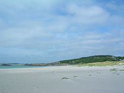 |
Jæren | Ogna Ogna Ogna is a village and former municipality in Rogaland county, Norway.Ogna was separated from Eigersund in 1839. It was merged with Nærbø and Varhaug to create the old municipality of Hå January 1, 1964.... –Bore Bore, Norway Bore is a village in Klepp, Norway, northwest of Kleppe. It is the site of Bore Church.... |
Rogaland Rogaland is a county in Western Norway, bordering Hordaland, Telemark, Aust-Agder and Vest-Agder. It is the center of the Norwegian petroleum industry, and as a result of this, Rogaland has the lowest unemployment rate of any county in Norway, 1.1%... |
44, 507 | Running along the endless ocean of the Jæren Jæren Jæren is a traditional district in the county of Rogaland. The others are Dalane, Ryfylke and Haugalandet.Jæren is the largest flat lowland area in Norway, stretching from the municipality of Randaberg in the north to Hå in the south. The coast is flat compared to the rest of the Norwegian coast,... coastline, the route passes endless sandy beaches and sand dunes. Norway's largest lowland region is dominated by agriculture and a well-kept cultural landscape. The coastline features several lighthouse. |
||
| Lofoten European route E10 European route E 10 is a road part of the International E-road network. It begins in Å, Norway and ends in Luleå, Sweden. The road is about 850 km in length... |
Fiskebøl Fiskebøl Fiskebøl is a village on the island of Austvågøy on the south shore of Hadselfjord in Hadsel, Norway. It has a ferry quay for the Melbu–Fiskebø Ferry.... –Å |
Nordland Nordland is a county in Norway in the North Norway region, bordering Troms in the north, Nord-Trøndelag in the south, Norrbottens län in Sweden to the east, Västerbottens län to the southeast, and the Atlantic Ocean to the west. The county was formerly known as Nordlandene amt. The county administration is... |
E10 European route E10 European route E 10 is a road part of the International E-road network. It begins in Å, Norway and ends in Luleå, Sweden. The road is about 850 km in length... , 82 Norwegian County Road 82 County Road 82 runs between Fiskebøl and Andenes in Nordland, Norway. The road runs through Hadsel, Sortland and Andøy. At Fiskebøl, the road intersects with E10 before crossing the Fiskebøl–Melbu Ferry. Bridges on the road include Andøy Bridge, Hadsel Bridge, Sortland Bridge, and Børøy Bridge... |
The Lofoten Lofoten Lofoten is an archipelago and a traditional district in the county of Nordland, Norway. Though lying within the Arctic Circle, the archipelago experiences one of the world's largest elevated temperature anomalies relative to its high latitude.-Etymology:... archipelago combines the open sea, current sounds, white beaches and steep, pointed mountains. The fishing hamlets not only retain an active industry but preserve the cultural heritage, such as rorbu Rorbu Rorbu is a traditional type of seasonal house used by fishermen, normally located in a fishing village. The buildings are built on land, but with the one end on poles in the water, allowing easy access to vessels. The style and term is used along the coast of Western Norway and Northern Norway, and... cabins. |
|||
| Rondane | Enden Enden Enden is a neighborhood of Ringebu, Norway. It is located where County Road 27 branches off from E6.... –Folldal Folldal Folldal is a municipality in Hedmark county, Norway. It is part of the traditional region of Dovre. The administrative centre of the municipality is the village of Folldal. The new municipality of Folldal was separated from Alvdal in 1914.-Name:... |
Hedmark Hedmark is a county in Norway, bordering Sør-Trøndelag, Oppland and Akershus. The county administration is in Hamar.Hedmark makes up the northeastern part of Østlandet, the southeastern part of the country. It includes a long part of the borderline with Sweden, Dalarna County and Värmland County. The... |
27 | The route runs along the east border of Rondane National Park Rondane National Park Rondane National Park is the oldest national park in Norway, established on 21 December 1962. The park contains ten peaks above , with the highest being Rondslottet at an altitude of . The park is an important habitat for herds of wild reindeer.... , protecting the Rondane massif, and west of a cultural landscape. The mountains are dry and well-suited for hiking and summit tours, including many marked paths and cabins. Along the route are also the mines at Folldal Folldal Folldal is a municipality in Hedmark county, Norway. It is part of the traditional region of Dovre. The administrative centre of the municipality is the village of Folldal. The new municipality of Folldal was separated from Alvdal in 1914.-Name:... . |
|||
| Ryfylke | Oanes Oanes Oanes is a village in Forsand, Norway, at the intersection between Lysefjorden and Høgsfjorden. It has a ferry quay for the Lauvvik–Oanes Ferry.... –Sauda Sauda is a municipality and industrial town in Rogaland county, Norway. It is part of the region of Ryfylke. Sauda was separated from Suldal in 1842... –Horda Horda, Norway Horda is a village on Røldalsvatnet in Odda, Norway. It is the location of the Horda Tunnel, a spiral tunnel on E134 and National Road 13.... |
Rogaland Rogaland is a county in Western Norway, bordering Hordaland, Telemark, Aust-Agder and Vest-Agder. It is the center of the Norwegian petroleum industry, and as a result of this, Rogaland has the lowest unemployment rate of any county in Norway, 1.1%... |
13 Norwegian National Road 13 National Road 13 is a national road which runs from Sandnes to Balestrand. The route is long and runs north–south through Rogaland, Hordaland and Sogn og Fjordane, following a more inward path than E39. From Balestrand to Førde, the route continues as County Road 13. The route has three ferries.... , 46, 520 |
The southern part of Ryfylke Ryfylke Ryfylke is a traditional district in Norway, located northeast of Stavanger and east of Haugesund. In the east it borders Setesdal and Sirdal.Ryfylke comprises the contemporary municipalities of Sauda, Suldal, Finnøy, Hjelmeland, Forsand, Strand, Kvitsøy and Rennesøy... has fertile landscape and calm skerries, in contrast to the rockslides, cliffs, fjords and mountains in the north. The nature is supplemented with smelting plants in Sauda Sauda is a municipality and industrial town in Rogaland county, Norway. It is part of the region of Ryfylke. Sauda was separated from Suldal in 1842... and the zinc mines in Allmannajuvet Allmannajuvet Allmannajuvet is a canyon in Sauda, Norway. During the 19th century there was a zinc mine there.... . Preikestolen Preikestolen Preikestolen or Prekestolen, also known by the English translations of Preacher's Pulpit or Pulpit Rock, and by the old local name Hyvlatonnå , is a massive cliff 604 metres above Lysefjorden, opposite the Kjerag plateau, in Forsand, Ryfylke, Norway... and the view of Lysefjord Lysefjord Lysefjord is a fjord located in Forsand in Ryfylke in south-western Norway... is a short side-trip away. |
|||
| Senja | Gryllefjord Gryllefjord Gryllefjord is a fishing village and also the administrative centre of Torsken municipality, on the island of Senja, in Troms county, Norway. Its population is 378.... –Botnhamn Botnhamn Botnhamn is a small place in Northern Norway, located more than north of the Arctic Circle on the northern part of the island of Senja. The place is spread out along the west side of the fjord of Stønnesbotn and is part of Lenvik municipality in Troms county. The population is 308. Botnhamn... |
Troms Troms or Romsa is a county in North Norway, bordering Finnmark to the northeast and Nordland in the southwest. To the south is Norrbotten Län in Sweden and further southeast is a shorter border with Lapland Province in Finland. To the west is the Norwegian Sea... |
86, 862 | The route follows the west coast of Senja Senja Senja is the second largest island in Norway . It is located along the Troms county coastline with Finnsnes as the closest town. Senja is connected to the mainland by the Gisund Bridge. The municipalities located on Senja are Lenvik , Berg, Torsken, and Tranøy... . It connects to National Tourist Route Andøy via a ferry, which combined offer an alternative to the E6 European route E6 European route E 6 is the designation for the main north-south road in Norway, and the west coast of Sweden, running from the southern tip of Sweden, at Trelleborg, into Norway and through almost all of the country north to Finnmark. The route ends close to the Norwegian border with Russia... . The route passes through several fishing villages, |
|||
| Sognefjellsvegen Sognefjellsvegen The Sognefjellsvegen or Sognefjellsveien is the highest mountain pass road in Northern Europe. It is located in Oppland and Sogn og Fjordane counties in Norway. It is a national tourist road and starts in the village of Lom in the municipality of Lom, it then travels over the Sognefjell mountain... |
Lom Lom Lom as an ethnic group:* Lom people, a Gypsy group, mainly in the CaucasusLom as a placename:* Lom, Norway, a municipality in Norway** Lom prisoner of war camp, a Norwegian prisoner of war camp in the above-mentioned location.... –Gaupne Gaupne Gaupne is a village which is the administrative center of the municipality of Luster in Sogn og Fjordane county, Norway. The village has a population of 1,075. The village is located along the Gaupnefjord, an arm of the Lustrafjord, about north of the village of Hafslo. The village of... |
Oppland Oppland is a county in Norway, bordering Sør-Trøndelag, Møre og Romsdal, Sogn og Fjordane, Buskerud, Akershus, Oslo and Hedmark. The county administration is in Lillehammer. Oppland is, together with Hedmark, one of the only two landlocked counties of Norway.... , Sogn og Fjordane Sogn og Fjordane is a county in Norway, bordering Møre og Romsdal, Oppland, Buskerud, and Hordaland. The county administration is in the town of Hermansverk in Leikanger municipality while the largest town is Førde.... |
55 | The mountain pass over Sognefjellet Sognefjellet Sognefjellet is a mountain pass through which Jotunheimen which connects Lustrafjorden with Ottadalen. The pass is locate din in Luster and Lom, Norway. Sognefjellsvegen, part of County Road 55 runs through the pass.... reaches 1434 m (4,704.7 ft) above mean sea level Above mean sea level The term above mean sea level refers to the elevation or altitude of any object, relative to the average sea level datum. AMSL is used extensively in radio by engineers to determine the coverage area a station will be able to reach... , the highest mountain pass in northern Europe. Only open in the summer, in May the snow banks on the side of the road can be 10 m (32.8 ft) tall. The route has views of emerald green mountain lakes, glaciers and peaks. It provides access to Jotunheimen National Park and Jostedalsbreen National Park Jostedalsbreen National Park Jostedalsbreen National Park is a national park in Norway that encompasses the largest glacier on the European mainland, Jostedalsbreen. The park was established by royal decree on 25 October 1991, and then in 1998, it was enlarged to the northwest... . |
|||
| Valdresflye | Garli Garli Garli is a cabin area in the northern part of Beitostølen in Øystre Slidre, Norway.... –Besstrond Besstrond Besstrond is an area in Vågå, Norway, on a hillside between Nedre Sjodalsvatnet and Øvre Sjodalsvatnet.... |
Oppland Oppland is a county in Norway, bordering Sør-Trøndelag, Møre og Romsdal, Sogn og Fjordane, Buskerud, Akershus, Oslo and Hedmark. The county administration is in Lillehammer. Oppland is, together with Hedmark, one of the only two landlocked counties of Norway.... |
51 | Valdresflye Valdresflye Valdresflye, also spelled Valdresflya and Valdresflyi, is a mountain plateau in the eastern-most part of Jotunheimen in Øystre Slidre, Norway. The summer-only County Road 51 runs over the plateau, reaching above mean sea level.... is a mountain plateau where the road reaches 1389 m (4,557.1 ft) above mean sea level Above mean sea level The term above mean sea level refers to the elevation or altitude of any object, relative to the average sea level datum. AMSL is used extensively in radio by engineers to determine the coverage area a station will be able to reach... . On the plateau the route has views towards Jotunheimen National Park, while further down the road passes through cultivated landscape with mountain pastures. |
|||
| Varanger | Varangerbotn Varangerbotn Varangerbotn is the administrative centre of Nesseby municipality, Norway. It is located in inner Varangerfjord.The band The BlackSheeps comes from Varangerbotn.... –Hamningberg Hamningberg Hamningberg is an abandoned fishing village in Båtsfjord, Norway. Traditionally a fishing village, it is one of very few places in Finnmark not burned down during the Second World War. It was depopulated during the 1960s, although some of the houses are still in use as cottages.... |
Finnmark Finnmark or Finnmárku is a county in the extreme northeast of Norway. By land it borders Troms county to the west, Finland to the south and Russia to the east, and by water, the Norwegian Sea to the northwest, and the Barents Sea to the north and northeast.The county was formerly known as Finmarkens... |
E75 European route E75 European route E 75 is part of the International E-road network, which is a series of main roads in Europe.The E 75 starts from Vardø, Norway in the Barents Sea and runs south through Finland, Poland, Czech Republic, Slovakia, Hungary, Serbia and Republic of Macedonia to Sitia, Greece on... , 341 |
The route follows the east coast of Varanger Varanger Peninsula Varanger Peninsula is a peninsula in Finnmark, north-eastern Norway, by the Barents Sea. The peninsula has the Tanafjord to the west, the Varangerfjord to the south and the Barents Sea to the north and east. Vadsø, Båtsfjord, Berlevåg, Vardø and Unjárga - Nesseby are the municipalities sharing the... , which borders the Barents Sea Barents Sea The Barents Sea is a marginal sea of the Arctic Ocean, located north of Norway and Russia. Known in the Middle Ages as the Murman Sea, the sea takes its current name from the Dutch navigator Willem Barents... . To the south the road runs through sheltered birtch forests and bogs, but by the time it reaches Vadsø Vadsø is a city and municipality in Finnmark county, Norway. The city is the administrative centre of the municipality and the county of Finnmark.... , the landscape has become lunar and jagged. During winter, the coastline is rampaged with storms, freezing sea fog and the Arctic night. In summer, the short Siberian heat blends with the never-ending day. The area has rich traditions within trade and is a melting pot of Russian, Finnish, Norwegian and Sami Sami people The Sami people, also spelled Sámi, or Saami, are the arctic indigenous people inhabiting Sápmi, which today encompasses parts of far northern Sweden, Norway, Finland, the Kola Peninsula of Russia, and the border area between south and middle Sweden and Norway. The Sámi are Europe’s northernmost... culture. |