

Trollstigen
Encyclopedia
Rauma, Norway
Rauma is a municipality in Møre og Romsdal county, Norway. It is part of the Romsdal region. The administrative centre is the village of Åndalsnes. Other villages include Vågstranda, Voll, Innfjorden, Veblungsnes, Verma, Isfjorden, Eidsbygda, Rødven, Åfarnes, and Mittet...
, Norway
Norway
Norway , officially the Kingdom of Norway, is a Nordic unitary constitutional monarchy whose territory comprises the western portion of the Scandinavian Peninsula, Jan Mayen, and the Arctic archipelago of Svalbard and Bouvet Island. Norway has a total area of and a population of about 4.9 million...
, part of Norwegian National Road 63
Norwegian national road 63
Norwegian County Road 63 is a Norwegian county road in Møre og Romsdal and a very small part in Oppland county, Norway. It begins at Langvatnet at Norwegian National Road 15 in the municipality of Skjåk in Oppland county and it heads north where it ends at the junction with the E136 near...
connecting Åndalsnes
Åndalsnes
is a town in the municipality of Rauma in Møre og Romsdal county, Norway. Åndalsnes is the administrative center of Rauma. The town has a population of 2,207...
in Rauma and Valldal
Valldal
Valldal is a valley in the municipality of Norddal in Møre og Romsdal, Norway. It is located north of the Norddalsfjorden. The village of Sylte is located at the end of the valley along the fjord...
in Norddal
Norddal
Norddal is a municipality in Møre og Romsdal county, Norway. It covers the easternmost part of the Sunnmøre region along the border with Oppland county...
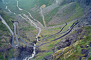
. It is a popular tourist attraction due to its steep incline of 9% and eleven hairpin bends up a steep mountain side. Trollstigen was opened on July 31, 1936, by King Haakon VII
Haakon VII of Norway
Haakon VII , known as Prince Carl of Denmark until 1905, was the first king of Norway after the 1905 dissolution of the personal union with Sweden. He was a member of the House of Schleswig-Holstein-Sonderburg-Glücksburg...
after 8 years of construction.
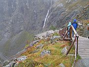
The road up is narrow with many sharp bends, and although it has been widened in recent years, vehicles over 12.4 metres long are prohibited from driving the road. At the top there is large parking place which allows visitors to leave their cars and walk for about ten minutes to a viewing balcony which overlooks the road with its bends and the Stigfossen waterfall. Stigfossen falls 320 metres down the mountain side. The pass has an elevation of approximately 850 metres.
Trollstigen is closed during the fall and winter months. A normal opening season stretches from mid-May to October, but may sometimes be shorter or longer due to changes in the weather conditions.
In the summer of 2005 the road was repaired and about 16 million NOK
Norwegian krone
The krone is the currency of Norway and its dependent territories. The plural form is kroner . It is subdivided into 100 øre. The ISO 4217 code is NOK, although the common local abbreviation is kr. The name translates into English as "crown"...
was spent on protection against rockfall, making the road safer to drive on.
See also
- List of highest paved roads in Europe
- List of mountain passes
- Stelvio PassStelvio PassThe Stelvio Pass , located in Italy, at 2757 m is the highest paved mountain pass in the Eastern Alps, and the second highest in the Alps, slightly below the Col de l'Iseran .-Location:...
- TransfăgărăşanTransfagarasanThe Transfăgărășan or DN7C, also known as Ceaușescu's folly is the second-highest paved road in Romania, and considered by some to be the most dramatic...