

National Register of Historic Places listings in northern Puerto Rico
Encyclopedia
This portion of National Register of Historic Places listings in Puerto Rico
is along the north coast, north plains, and north slopes of the Cordillera, from Camuy to Toa Alta.
See also:
Names of places given are as appear in the National Register, reflecting name as given in NRHP application at the date of listing. Note, the National Register name system does not accommodate Spanish á, ñ and other letters.
Arecibo
Camuy
Dorado
Hatillo
Manatí
Toa Alta
Toa Baja
Vega Alta
Vega Baja
is along the north coast, north plains, and north slopes of the Cordillera, from Camuy to Toa Alta.
See also:
- National Register of Historic Places listings in southern Puerto RicoNational Register of Historic Places listings in southern Puerto RicoThis is a list of properties and districts in the southern municipalities of Puerto Rico that are listed on the National Register of Historic Places. It includes places along the southern coast, and on islands, and in the peaks and on the south slope of Puerto Rico's Cordillera Central.The area...
- National Register of Historic Places listings in western Puerto RicoNational Register of Historic Places listings in western Puerto RicoThis is a list of properties and districts in the Porta del Sol municipalities of Puerto Rico that are listed on the National Register of Historic Places...
- National Register of Historic Places listings in eastern Puerto RicoNational Register of Historic Places listings in eastern Puerto RicoThis portion of National Register of Historic Places listings in Puerto Ricocovers the eastern region of Puerto Rico, from Loiza in the northeast to Maunabo in the southeast...
- National Register of Historic Places listings in central Puerto RicoNational Register of Historic Places listings in central Puerto RicoThis portion of National Register of Historic Places listings in Puerto Ricois along the central mountain region, from Lares in the central-west to Gurabo in the central-east, including the slopes of the Cordillera.See also:...
- National Register of Historic Places listings in metropolitan San Juan, Puerto Rico
Names of places given are as appear in the National Register, reflecting name as given in NRHP application at the date of listing. Note, the National Register name system does not accommodate Spanish á, ñ and other letters.
AreciboArecibo, Puerto RicoArecibo is a municipality in the northern midwest coast of Puerto Rico and located by the Atlantic Ocean, north of Utuado and Ciales; east of Hatillo; and west of Barceloneta, and Florida. Arecibo is spread over 18 wards and Arecibo Pueblo...
| Landmark name | Image | Date listed | Location | District/Ward | Summary | |
|---|---|---|---|---|---|---|
| 1 | Calle Gonzalo Marín No. 61 | 61 Gonzalo Marín Steet 18°28′19"N 66°42′53.5"W |
Arecibo Pueblo | |||
| 2 | Cambalache Bridge | Over Rio Grande de Arecibo, west of Puerto Rico Highway 2 Puerto Rico Highway 2 Puerto Rico Highway 2, the longest highway in the Commonwealth of Puerto Rico at about 156 miles long, connects San Juan to Ponce.... 18°27′12.5"N 66°42′8.5"W |
Camblache and Tanamá | |||
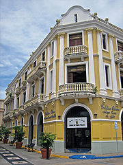
| 3 | Casa Alcaldía de Arecibo | José de Diego Avenue 18°28′22"N 66°42′56"W |
Arecibo Pueblo | A city hall City hall In local government, a city hall, town hall or a municipal building or civic centre, is the chief administrative building of a city... , in Classical Revival style |
||
| 4 | Casa Cordova | 14 Gonzalo Marín Street 18°28′21"N 66°42′48"W |
Arecibo Pueblo | |||
| 5 | Casa Ulanga | 7 Gonzalo Marín Street 18°28′21"N 66°42′46"W |
Arecibo Pueblo | Used as a bank, store, city hall of Arecibo, hospital, jail, tribunal, and Cultural Center. | ||
| 6 | Casa de la Diosa Mita | 251 Fernandez Juncos Street 18°28′18"N 66°43′8.5"W |
Arecibo Pueblo | A Beaux Arts house | ||
| 7 | Corregimiento Plaza Theater Corregimiento Plaza Theater Corregimiento Plaza Theater in Arecibo, Puerto Rico, also known as Oliver Theater, was built in 1876. It was listed on the National Register of Historic Places in 1986.... |
Llaguerry and Toribio Pagan Streets 18°28′23"N 66°42′55"W |
Arecibo Pueblo | |||
| 8 | Edificio Oliver Edificio Oliver Edificio Oliver in Arecibo, Puerto Rico was built in 1914. The building houses government offices for the municipality of Arecibo. It was listed on the National Register of Historic Places in 1986.-References:... |
 |
64 José de Diego Avenue 18°28′22"N 66°42′48.5"W |
Arecibo Pueblo | ||
| 9 | Faro de Arecibo Arecibo Light Arecibo Light is a historic lighthouse located in the city of Arecibo, Puerto Rico. It is also known as "Morrillo's Lighthouse" because it is location on top of a rocky mountain known as Punta Morrillo. The lighthouse was constructed and was lit on 1898... |
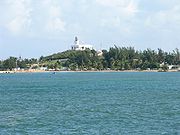 |
Northeast of Arecibo, off Puerto Rico Highway 66 Puerto Rico Highway 66 Puerto Rico Highway 66 is a main tollway which parallels Puerto Rico Highway 3 going from the city of Carolina, Puerto Rico via a cloverleaf interchange with PR-26 and PR-3 and ending in the municipality of Canóvanas, Puerto Rico with an intersection of PR-3... 18°28′55"N 66°41′55"W |
Arecibo Pueblo | A "faro" (lighthouse Lighthouse A lighthouse is a tower, building, or other type of structure designed to emit light from a system of lamps and lenses or, in older times, from a fire, and used as an aid to navigation for maritime pilots at sea or on inland waterways.... } built in 1898; Lighthouse System of Puerto Rico TR |
|
| 10 | Gonzalo Marín 101 | 101 Gonzalo Marín Street 18°28′18.5"N 66°42′56"W |
Arecibo Pueblo | |||
| 11 | National Astronomy and Ionosphere Center Arecibo Observatory The Arecibo Observatory is a radio telescope near the city of Arecibo in Puerto Rico. It is operated by SRI International under cooperative agreement with the National Science Foundation... |
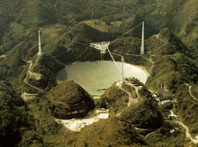 |
San Rafael sector, Puerto Rico Highway 625 18°20′39.5"N 66°45′9.5"W |
Esperanza | ||
| 12 | Palacio del Marqués de las Claras | 58 Gonzalo Marín Street 18°28′20.6"N 66°42′53"W |
Arecibo Pueblo | |||
| 13 | Paseo Víctor Rojas Paseo Victor Rojas Paseo Víctor Rojas, also known as El Fuerte or Paseo de Damas, in Arecibo, Puerto Rico, was built in 1881. It was listed on the National Register of Historic Places in 1986.-References:... |
Gonzalo Marín Street at José de Diego Avenue 18°28′22"N 66°42′43"W |
Arecibo Pueblo |
CamuyCamuy, Puerto RicoCamuy is a municipality in Puerto Rico located on the Valley of Quebradillas, bordering the Atlantic Ocean, north of Lares; east of Quebradillas; and west of Hatillo. Camuy is spread over 12 wards and Camuy Pueblo...
| Landmark name | Image | Date listed | Location | City/ Town | Summary | |
|---|---|---|---|---|---|---|
| 1 | Antiguo Casino Camuyano Antiguo Casino Camuyano Antiguo Casino Camuyano dates from 1910. It was listed on the U.S. National Register of Historic Places in 1984.-External links:* -References:... |
Estella and Munoz Rivera Streets 18°29′20"N 66°49′32"W |
Camuy Pueblo | |||
| 2 | Ernesto Memorial Chapel | Intersection of PR-486 and PR-488, Abra Honda Ward 18°25′59"N 66°51′17"W |
Camuy vicinity | |||
| 3 | Hacienda La Sabana Hacienda La Sabana Hacienda La Sabana near Camuy, Puerto Rico, was built in 1773. It was listed on the National Register of Historic Places in 1985.... |
Puerto Rico Highway 119 Puerto Rico Highway 119 Puerto Rico Highway 119 is a long north-to-south highway in Puerto Rico that goes from Puerto Rico Highway 2 in Hatillo, close to its border with Camuy to the same highway in San Germán. It goes through the municipalities of Camuy, San Sebastián, Las Marías and Maricao before ending in the freeway... 18°27′14.5"N 66°53′2.5"W |
Camuy Arriba |
DoradoDorado, Puerto RicoDorado is a small tourist town in the northern coast of Puerto Rico, west of San Juan and is located in the northern region of the island, bordering the Atlantic Ocean, north of Toa Alta, east of Vega Alta, and west of Toa Baja. Dorado is spread over five barrios and Dorado Pueblo...
| Landmark name | Image | Date listed | Location | District/Ward | Summary | |
|---|---|---|---|---|---|---|
| 1 | Casa del Rey Casa del Rey Casa del Rey, the "King's House," is a historic place in the town of Dorado, in Puerto Rico. It is also known as Cuartel de la Guardia de Milicias, Parador, or Carcel Municipal.It was constructed as a parador, or inn, about 1823... |
292 Mendez Vigo Street 18°27′32"N 66°15′37.5"W |
Dorado Pueblo | Built from 1823 | ||
| 2 | Dona Antonia Ramírez Residencia | Puerto Rico Highway 693 18°25′54"N 66°16′20"W |
Higuillar | Italianate building from 1921, designed by Camilo Munoz | ||
| 3 | Hacienda de Carlos Vassallo | Puerto Rico Highway 693 18°24′44.5"N 66°15′48"W |
Maguayo | |||
| 4 | Jacinto López Martínez Grammar School | Norte and San Quintin Streets 18°27′36"N 66°15′44"W |
Dorado Pueblo | Mission/Spanish Revival school from 1923, designed by Pedro Adolfo de Castro | ||
| 5 | Residencia Don Andrés Hernández | 196 Norte Steet 18°27′36"N 66°15′42.5"W |
Dorado Pueblo | Built in 1880 | ||
| 6 | SS ANTONIO LÓPEZ Shipwreck Site and Remains Antonio Lopez (shipwreck) Antonio López , also known as SS ANTONIO LÓPEZ Shipwreck Site and Remains, in Puerto Rico. It is one of Puerto Rico's 63 National Historic Landmarks.-History:... |
 |
Address Restricted 18°28′48"N 66°13′50"W |
Mameyal | Sunken steel propeller steam liner, a U.S. National Historic Landmark National Historic Landmark A National Historic Landmark is a building, site, structure, object, or district, that is officially recognized by the United States government for its historical significance... |
HatilloHatillo, Puerto RicoHatillo is a municipality located on Puerto Rico's north coast, bordered by the Atlantic Ocean to the north, Lares and Utuado to the south, Camuy to the west, and Arecibo to the east. According to the 2000 US Census Hatillo is spread over 9 wards and Hatillo Pueblo...
| Landmark name | Image | Date listed | Location | District/Ward | Summary | |
|---|---|---|---|---|---|---|
| 1 | Church Nuestra Señora del Carmen of Hatillo Church Nuestra Senora del Carmen of Hatillo Church Nuestra Señora del Carmen of Hatillo is a church in Hatillo, Puerto Rico dating from 1879. It was listed on the National Register of Historic Places in 1984.-See also:*... |
Luis M. Lacomba Street 18°29′18.5"N 66°49′30.5"W |
Hatillo |
ManatíManatí, Puerto RicoManatí is a municipality of Puerto Rico in the northern coast, north of Morovis and Ciales; east of Florida and Barceloneta; and west of Vega Baja. Manatí is spread over 8 wards and Manatí Pueblo...
| Landmark name | Image | Date listed | Location | District/Ward | Summary | |
|---|---|---|---|---|---|---|
| 1 | Brunet-Calaf Residence | Corner of Quinones and Patriota Pozo Street 18°25′39"N 66°29′34"W |
Manatí Pueblo | |||
| 2 | Church Nuestra Señora de la Candelaria y San Matías of Manatí Church Nuestra Senora de la Candelaria y San Matias of Manati Church Nuestra Señora de la Candelaria y San Matías of Manatí is a church in the municipality of Manati, Puerto Rico. It was built in 1729. It was listed on the U.S. National Register of Historic Places in 1984.-See also:*... |
Patriota Pozo Street, Town Plaza 18°25′38.5"N 66°29′32"W |
Manatí Pueblo | |||
| 3 | Hacienda Azucarera la Esperanza | Northwest of Manatí on Puerto Rico Highway 616 18°27′54"N 66°30′53"W |
Tierras Nuevas Poniente | |||
| 4 | La Colectiva Tabacalera | 18 Quinones Street 18°25′39"N 66°29′33"W |
Manatí Pueblo | Industrial Neoclassic building from 1880 | ||
| 5 | Plaza del Mercado de Manatí | Quinones, Padial and Baldorioty Streets 18°25′37.5"N 66°29′35.5"W |
Manatí Pueblo | Art Deco Art Deco Art deco , or deco, is an eclectic artistic and design style that began in Paris in the 1920s and flourished internationally throughout the 1930s, into the World War II era. The style influenced all areas of design, including architecture and interior design, industrial design, fashion and... and Mission/Spanish Revival architecture from 1925, designed by Rafael Carmoega Rafael Carmoega Rafael Carmoega Morales was a Puerto Rican architect from Ponce, Puerto Rico. He was the first Puerto Rican to become State Architect, a position within the Department of the Interior which he held from 1921 to 1936... |
Toa AltaToa Alta, Puerto RicoToa Alta is a municipality of Puerto Rico located in the northern coast of the island, north of Naranjito; south of Dorado and Toa Baja; east of Vega Alta and Corozal; and west of Bayamón. Toa Alta is spread over eight wards and Toa Alta Pueblo...
| Landmark name | Image | Date listed | Location | City/ Town | Summary | |
|---|---|---|---|---|---|---|
| 1 | Church Nuestra Señora de la Concepción y San Fernando of Toa Alta | Ponce de Leon Street, Town Plaza 18°23′18"N 66°14′50.5"W |
Toa Alta Pueblo | Church from 1752 |
Toa BajaToa Baja, Puerto RicoToa Baja is a municipality of Puerto Rico located in the northern coast, north of Toa Alta and Bayamón; east of Dorado; and west of Cataño. Toa Baja is spread over 5 wards and Toa Baja Pueblo . It is part of the San Juan-Caguas-Guaynabo Metropolitan Statistical Area.Toa Baja considered to be a...
| Landmark name | Image | Date listed | Location | District/Ward | Summary | |
|---|---|---|---|---|---|---|
| 1 | Iglesia Parroquial de San Pedro Apostol de Toa Baja | 47 Las Flores Street 18°26′33"N 66°15′18"W |
Toa Baja Pueblo | |||
| 2 | Santa Elena Hacienda | North of the junction of Puerto Rico Highways 2 Puerto Rico Highway 2 Puerto Rico Highway 2, the longest highway in the Commonwealth of Puerto Rico at about 156 miles long, connects San Juan to Ponce.... and 165 Puerto Rico Highway 165 Puerto Rico Highway 165, or PR-165, is the road that goes from Naranjito to Guaynabo. The highway passes by Toa Alta, Toa Baja, Dorado, Levittown, Cataño and Guaynabo.... 18°25′33"N 66°15′5"W |
Media Luna |
Vega AltaVega Alta, Puerto RicoVega Alta is a municipality of Puerto Rico. Vega Alta is located on the northern coast of the island, north of Morovis and Corozal; east of Vega Baja; and west of Dorado with an area of . Vega Alta is spread over seven wards and Vega Alta Pueblo...
| Landmark name | Image | Date listed | Location | District/Ward | Summary | |
|---|---|---|---|---|---|---|
| 1 | Church Inmaculada Conception of Vega Alta Church Inmaculada Conception of Vega Alta The Church Inmaculada Conception of Vega Alta is a church built by 1831 on the town plaza of Vega Alta, Puerto Rico.It was listed on the U.S. National Register of Historic Places in 1984.... |
Town Plaza 18°24′50"N 66°19′48"W |
Vega Alta Vega Alta, Puerto Rico Vega Alta is a municipality of Puerto Rico. Vega Alta is located on the northern coast of the island, north of Morovis and Corozal; east of Vega Baja; and west of Dorado with an area of . Vega Alta is spread over seven wards and Vega Alta Pueblo... |
Church dating from 1831 |
Vega BajaVega Baja, Puerto RicoVega Baja is a municipality in north central Puerto Rico located in the northern coast, north of Morovis; east of Manatí; and west of Vega Alta. Vega Baja is spread over 13 wards and Vega Baja Pueblo...
| Landmark name | Image | Date listed | Location | District/Ward | Summary | |
|---|---|---|---|---|---|---|
| 1 | Casa Alonso Casa Alonso Casa Alonso is a Spanish colonial style house in Vega Baja, Puerto Rico. It was listed on the National Register of Historic Places in 1996. The house is also known as Museo de Arte, Historia y Cultura Casa Alonso.-External links:* -References:**... |
34 Betances Avenue 18°26′37"N 66°23′8"W |
Vega Baja Pueblo | |||
| 2 | Church Santa María del Rosario of Vega Baja | Town Plaza 18°26′50"N 66°23′12"W |
Cabo Caribe | Church from 1860 | ||
| 3 | Panteón Otero-Martínez Panteón Otero-Martinez Panteón Otero-Martínez, also known as Otero-Martinez Mausoleum, was built in 1886. It is located in the Old Bega Baja Cemetery, in Vega Baja, Puerto Rico. It was listed on the National Register of Historic Places as "Panteon Otero-Martinez" in 1984.... |
Old Bega Baja Cemetery, Puerto Rico Highway 670 18°26′41"N 66°23′35"W |
Vega Baja Vega Baja, Puerto Rico Vega Baja is a municipality in north central Puerto Rico located in the northern coast, north of Morovis; east of Manatí; and west of Vega Alta. Vega Baja is spread over 13 wards and Vega Baja Pueblo... |
A mausoleum Mausoleum A mausoleum is an external free-standing building constructed as a monument enclosing the interment space or burial chamber of a deceased person or persons. A monument without the interment is a cenotaph. A mausoleum may be considered a type of tomb or the tomb may be considered to be within the... |
||
| 4 | Paso del Indio Site Paso del Indio Site Paso del Indio Site, also known as VB-4, is an archeological site in Vega Baja, Puerto Rico. It was listed on the U.S. National Register of Historic Places in 2007.-References:... |
Address Restricted | Río Arriba | An archeological site |