

National Register of Historic Places listings in Yukon-Koyukuk Census Area, Alaska
Encyclopedia
This is intended to be a complete list of the properties and districts on the National Register of Historic Places
National Register of Historic Places
The National Register of Historic Places is the United States government's official list of districts, sites, buildings, structures, and objects deemed worthy of preservation...
in Yukon-Koyukuk Census Area
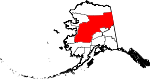
Yukon-Koyukuk Census Area, Alaska
Yukon-Koyukuk Census Area is a census area located in the state of Alaska, United States. As of the 2010 census, the population was 5,588. It is part of the unorganized borough and therefore has no borough seat...
, Alaska
Alaska
Alaska is the largest state in the United States by area. It is situated in the northwest extremity of the North American continent, with Canada to the east, the Arctic Ocean to the north, and the Pacific Ocean to the west and south, with Russia further west across the Bering Strait...
, United States
United States
The United States of America is a federal constitutional republic comprising fifty states and a federal district...
. The locations of National Register properties and districts for which the latitude and longitude coordinates are included below, may be seen in a Google map.
There are 17 properties and districts listed on the National Register in the census area.
Current listings
| Landmark name | Image | Date listed | Location | Community | Summary | |
|---|---|---|---|---|---|---|
| 1 | Ed Beiderman Fish Camp Biederman's Cabin Biederman's Cabin, also called Biederman's Fish Camp, is a privately owned cabin on the Yukon River in Alaska. Located within the Yukon-Charley Rivers National Preserve, it is maintained as a historic site representing the subsistence lifestyle employed by Interior Alaska residents during the early... |
Left bank of the Yukon River Yukon River The Yukon River is a major watercourse of northwestern North America. The source of the river is located in British Columbia, Canada. The next portion lies in, and gives its name to Yukon Territory. The lower half of the river lies in the U.S. state of Alaska. The river is long and empties into... ½ mile down across from the Kandick River 65°21′58"N 143°18′1"W |
Eagle Eagle, Alaska Eagle is a city located along the United States-Canada border in the Southeast Fairbanks Census Area, Alaska, United States. It includes Eagle Historic District, a U.S. National Historic Landmark. The population was 129 at the 2000 census... |
|||
| 2 | Bettles Lodge | Bettles Field, off Winter Trail, approximately 3.5 miles east of Bettles 66°55′7"N 151°30′59"W |
Bettles | |||
| 3 | Central House | Mile 128 on the Steese Highway Steese Highway The Steese Highway is a highway in the Interior region of the U.S. state of Alaska that extends from Fairbanks to Circle, a town on the Yukon River about 50 miles south of the Arctic Circle. The highway was completed in 1927 and is named for U.S. Army General James G. Steese, a former president... 65°34′20"N 144°47′45"W |
Central Central, Alaska Central is a census-designated place in Yukon-Koyukuk Census Area, Alaska, United States. At the 2000 census the population was 134. Every February, Central hosts a checkpoint for the long-distance Yukon Quest sled dog race.-Geography:... |
|||
| 4 | Christ Church Mission | In Anvik 62°39′16"N 160°12′3"W |
Anvik Anvik, Alaska Anvik is a city, home to the Deg Hit'an people, in the Yukon-Koyukuk Census Area, Alaska, United States. The name Anvik, which became the common usage despite multiple names at the time, may have come from early Russian explorers. The native name in the Deg Xinag language is Deloy Ges... |
|||
| 5 | Coal Creek Historic Mining District Coal Creek Historic Mining District The Coal Creek Historic Mining District is a gold-mining area in the Yukon-Charley Rivers National Preserve of Alaska. It features a gold dredge and a supporting community of several dozen buildings, established by mining entrepreneur Ernest Patty.... |
 |
Along the Yukon River Yukon River The Yukon River is a major watercourse of northwestern North America. The source of the river is located in British Columbia, Canada. The next portion lies in, and gives its name to Yukon Territory. The lower half of the river lies in the U.S. state of Alaska. The river is long and empties into... , southeast of Circle, in the Yukon-Charley Rivers National Park 65°18′29"N 143°11′27"W |
Circle Circle, Alaska Circle is a census-designated place in Yukon-Koyukuk Census Area, Alaska, United States. At the 2000 census the population was 100.... |
||
| 6 | George McGregor Cabin | Left bank of the Yukon River Yukon River The Yukon River is a major watercourse of northwestern North America. The source of the river is located in British Columbia, Canada. The next portion lies in, and gives its name to Yukon Territory. The lower half of the river lies in the U.S. state of Alaska. The river is long and empties into... 2 miles down from Coal Creek 65°21′4"N 143°7′36"W |
Eagle Eagle, Alaska Eagle is a city located along the United States-Canada border in the Southeast Fairbanks Census Area, Alaska, United States. It includes Eagle Historic District, a U.S. National Historic Landmark. The population was 129 at the 2000 census... |
|||
| 7 | Mission Church | Eastern fork of Chandalar River Chandalar River The Chandalar River is a river in Alaska. Its peak flow recorded by the USGS was 62,800 cubic feet per second , on June 9, 1968.... 68°7′32"N 145°20′25"W |
Arctic Village Arctic Village, Alaska Arctic Village is an unincorporated Native American village and a census-designated place in Yukon-Koyukuk Census Area, Alaska, United States. As of the 2000 census, the population of the CDP was 152. The village is located in the large Gwitch'in speaking region of Alaska, and the local dialect... |
|||
| 8 | Nenana Depot | A St. 64°33′52"N 149°6′2"W |
Nenana Nenana, Alaska Nenana is a Home Rule City in the Yukon-Koyukuk Census Area of the Unorganized Borough of the U.S. state of Alaska. Nenana lies at the juncture of the Nenana River and the Tanana River. The population was 402 at the 2000 census. "Nenana" means 'a good place to camp between two rivers.'-History... |
|||
| 9 | Old Mission House | Ft. Yukon 66°34′5"N 145°16′24"W |
Fort Yukon Fort Yukon, Alaska As of the census of 2000, there were 595 people, 225 households, and 137 families residing in the city. The population density was 85.0 people per square mile . There were 317 housing units at an average density of 45.3 per square mile... |
|||
| 10 | Presentation of Our Lord Chapel | In Nikolai 62°58′3"N 154°9′42"W |
Nikolai Nikolai, Alaska Nikolai is a city in Yukon-Koyukuk Census Area, Alaska, United States. The population was 100 at the 2000 census.-Geography:Nikolai is located at .... |
|||
| 11 | Ruby Roadhouse | Olson St. 64°44′25"N 155°29′25"W |
Ruby Ruby, Alaska Ruby is a city in Yukon-Koyukuk Census Area, Alaska, United States. At the 2000 census the population was 188.-Geography:Ruby is located at .According to the United States Census Bureau, the city has a total area of .... |
|||
| 12 | Frank Slaven Roadhouse Slaven's Cabin Slaven's Cabin, also called Slaven's Roadhouse and Frank Slaven Roadhouse, is a public-use facility in the Yukon-Charley Rivers National Preserve in Alaska... |
.jpg) |
Left bank of the Yukon River Yukon River The Yukon River is a major watercourse of northwestern North America. The source of the river is located in British Columbia, Canada. The next portion lies in, and gives its name to Yukon Territory. The lower half of the river lies in the U.S. state of Alaska. The river is long and empties into... ¼ mile from the mouth of Coal Creek 65°20′40"N 143°7′35"W |
Eagle Eagle, Alaska Eagle is a city located along the United States-Canada border in the Southeast Fairbanks Census Area, Alaska, United States. It includes Eagle Historic District, a U.S. National Historic Landmark. The population was 129 at the 2000 census... |
||
| 13 | Sourdough Inn | Junction of 1st and Sled Sts. 66°33′49"N 145°16′6"W |
Fort Yukon Fort Yukon, Alaska As of the census of 2000, there were 595 people, 225 households, and 137 families residing in the city. The population density was 85.0 people per square mile . There were 317 housing units at an average density of 45.3 per square mile... |
|||
| 14 | Tanana Mission | East of Tanana 65°10′18"N 152°2′17"W |
Tanana Tanana, Alaska Tanana is a city in the Yukon-Koyukuk Census Area in the U.S. state of Alaska. At the 2000 census the population was 308. It is formerly known as Clachotin... |
|||
| 15 | Teklanika Archeological District | On a knoll overlooking the Teklanika River Teklanika River The Teklanika River is a feeder stream to the Yukon River drainage and a tributary of the Nenana River in the central interior region of Alaska. Flowing northward from headwaters at the Cantwell Glacier in the Alaska Range and reaching to the Tanana River, it drains an area widely visited by... 63°40′35"N 149°45′20"W |
Toklat | |||
| 16 | Tolovana Roadhouse | Sled Rd. 64°50′52"N 149°48′18"W |
Nenana Nenana, Alaska Nenana is a Home Rule City in the Yukon-Koyukuk Census Area of the Unorganized Borough of the U.S. state of Alaska. Nenana lies at the juncture of the Nenana River and the Tanana River. The population was 402 at the 2000 census. "Nenana" means 'a good place to camp between two rivers.'-History... |
|||
| 17 | Woodchopper Roadhouse | Left bank of the Yukon River Yukon River The Yukon River is a major watercourse of northwestern North America. The source of the river is located in British Columbia, Canada. The next portion lies in, and gives its name to Yukon Territory. The lower half of the river lies in the U.S. state of Alaska. The river is long and empties into... 1 mile up from Woodchopper Creek 65°20′58"N 143°17′56"W |
Eagle Eagle, Alaska Eagle is a city located along the United States-Canada border in the Southeast Fairbanks Census Area, Alaska, United States. It includes Eagle Historic District, a U.S. National Historic Landmark. The population was 129 at the 2000 census... |
See also
- List of National Historic Landmarks in Alaska
- National Register of Historic Places listings in Alaska