
National Register of Historic Places listings in St. Louis County, Minnesota
Encyclopedia
St. Louis County, Minnesota
contains over 100 properties that are listed on the National Register of Historic Places
. Many of these places are associated with the city of Duluth
's role as the westernmost port on the Great Lakes
, shared with Superior, Wisconsin
. The iron ore of the Mesabi Range
and the Vermilion Range
led to the development of the cities of Chisholm
, Hibbing
, Virginia
, and Ely
. Three of the iron mines are National Historic Landmark
s: Hull-Rust-Mahoning Open Pit Iron Mine
, Mountain Iron Mine
, and the underground Soudan Iron Mine.
St. Louis County, Minnesota
St. Louis County is a county located in the U.S. state of Minnesota. As of 2010, the population was 200,226. Its county seat is Duluth. It is the largest county by total area in Minnesota, and the second largest in the United States east of the Mississippi River; in land area alone, after Aroostook...
contains over 100 properties that are listed on the National Register of Historic Places
National Register of Historic Places
The National Register of Historic Places is the United States government's official list of districts, sites, buildings, structures, and objects deemed worthy of preservation...
. Many of these places are associated with the city of Duluth
Duluth, Minnesota
Duluth is a port city in the U.S. state of Minnesota and is the county seat of Saint Louis County. The fourth largest city in Minnesota, Duluth had a total population of 86,265 in the 2010 census. Duluth is also the second largest city that is located on Lake Superior after Thunder Bay, Ontario,...
's role as the westernmost port on the Great Lakes
Great Lakes
The Great Lakes are a collection of freshwater lakes located in northeastern North America, on the Canada – United States border. Consisting of Lakes Superior, Michigan, Huron, Erie, and Ontario, they form the largest group of freshwater lakes on Earth by total surface, coming in second by volume...
, shared with Superior, Wisconsin
Superior, Wisconsin
Superior is a city in and the county seat of Douglas County, Wisconsin, United States. The population was 26,960 at the 2010 census. Located at the junction of U.S. Highways 2 and 53, it is north of and adjacent to both the Village of Superior and the Town of Superior.Superior is at the western...
. The iron ore of the Mesabi Range
Mesabi Range
The Mesabi Iron Range is a vast deposit of iron ore and the largest of four major iron ranges in the region collectively known as the Iron Range of Minnesota. Discovered in 1866, it is the chief deposit of iron ore in the United States. The deposit is located in northeast Minnesota, largely in...
and the Vermilion Range
Vermilion Range (Minnesota)
The Vermilion Range exists between Tower and Ely, Minnesota, and contains significant deposits of iron ore. The Vermilion, along with the Mesabi and Cuyuna Ranges, constitute the Iron Ranges of northern Minnesota which were deposited in the Animikie Group...
led to the development of the cities of Chisholm
Chisholm, Minnesota
As of the census of 2000, there were 4,960 people, 2,178 households, and 1,287 families residing in the city. The population density was 1,129 people per square mile . There were 2,375 housing units at an average density of 540/sq mi...
, Hibbing
Hibbing, Minnesota
Hibbing is a city in Saint Louis County, Minnesota, United States. The population was 16,361 at the 2010 census. The city was built on the rich iron ore of the Mesabi Iron Range. At the edge of town is the largest open-pit iron mine in the world. U.S...
, Virginia
Virginia, Minnesota
As of the census of 2000, there were 9,157 people, 4,333 households, and 2,270 families residing in the city. The population density was 486.1 people per square mile . There were 4,692 housing units at an average density of 249.1 per square mile...
, and Ely
Ely, Minnesota
As of the census of 2000, there were 3,724 people, 1,912 households, and 916 families residing in the city. The population density was 1,369.5 people per square mile . There were 1,912 housing units at an average density of 703.2 per square mile...
. Three of the iron mines are National Historic Landmark
National Historic Landmark
A National Historic Landmark is a building, site, structure, object, or district, that is officially recognized by the United States government for its historical significance...
s: Hull-Rust-Mahoning Open Pit Iron Mine
Hull-Rust-Mahoning Open Pit Iron Mine
The Hull-Rust-Mahoning Mine in Hibbing, Minnesota, is one of the largest open pit iron mines in the world. The mine, located in the Mesabi Range, supplied as much as one-fourth of all the iron ore mined in the United States during its peak production during World War I and World War II.This area of...
, Mountain Iron Mine
Mountain Iron Mine
The discovery of Mountain Iron Mine in Mountain Iron, Minnesota in 1890 represents the beginning of the exploitation of the Mesabi Range iron ore in the Iron Range of northeast Minnesota. The Mesabi Range and nearby Vermilion Range led Minnesota to become the nation's largest producer of iron ore...
, and the underground Soudan Iron Mine.
| Landmark name | Image | Date listed | Location | City or Town | Summary | |
|---|---|---|---|---|---|---|
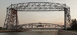
| 1 | Aerial Lift Bridge Aerial Lift Bridge The Aerial Lift Bridge is a major landmark in the port city of Duluth, Minnesota. The span is a vertical lift bridge, which is rather uncommon, but it began life as an extremely rare transporter bridge—the first of just two such bridges ever constructed in the United States... |
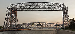 |
Lake Ave. 46°46′45"N 92°5′34"W |
Duluth Duluth, Minnesota Duluth is a port city in the U.S. state of Minnesota and is the county seat of Saint Louis County. The fourth largest city in Minnesota, Duluth had a total population of 86,265 in the 2010 census. Duluth is also the second largest city that is located on Lake Superior after Thunder Bay, Ontario,... |
||
| 2 | Elias and Lisi Aho Historic Farmstead | Off Township Road 358 47°39′23"N 92°8′58"W |
Tower Tower, Minnesota As of the census of 2000, there are 479 people in the city, organized into 233 households and 137 families. The population density is 176.8 people per square mile . There are 295 housing units at an average density of 108.9 per square mile... |
|||
| 3 | Alango School | County Highways 22 and 25 47°46′26"N 92°47′33"W |
Cook Cook, Minnesota Cook is a city in Saint Louis County, Minnesota, United States. The population was 574 at the 2010 census.U.S. Highway 53 and Minnesota Highway 1 are two of the main arterial routes in the community.... |
|||
| 4 | Andrew G. Anderson House | 1001 E. Howard St. 47°25′40"N 92°55′46"W |
Hibbing Hibbing, Minnesota Hibbing is a city in Saint Louis County, Minnesota, United States. The population was 16,361 at the 2010 census. The city was built on the rich iron ore of the Mesabi Iron Range. At the edge of town is the largest open-pit iron mine in the world. U.S... |
|||
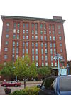
| 5 | Androy Hotel | 592 E. Howard St. 47°25′38"N 92°56′10"W |
Hibbing Hibbing, Minnesota Hibbing is a city in Saint Louis County, Minnesota, United States. The population was 16,361 at the 2010 census. The city was built on the rich iron ore of the Mesabi Iron Range. At the edge of town is the largest open-pit iron mine in the world. U.S... |
|||
| 6 | Archaeological Site No. 21SL82 | Address Restricted | International Falls International Falls, Minnesota International Falls is a city in and the county seat of Koochiching County, Minnesota, United States. The population was 6,424 at the 2010 census.... |
|||
| 7 | Archeological Site 21SL141 | Address Restricted | International Falls International Falls, Minnesota International Falls is a city in and the county seat of Koochiching County, Minnesota, United States. The population was 6,424 at the 2010 census.... |
|||
| 8 | Archeological Site 21SL35 | Address Restricted | International Falls International Falls, Minnesota International Falls is a city in and the county seat of Koochiching County, Minnesota, United States. The population was 6,424 at the 2010 census.... |
|||
| 9 | Archeological Site 21SL55 | Address Restricted | International Falls International Falls, Minnesota International Falls is a city in and the county seat of Koochiching County, Minnesota, United States. The population was 6,424 at the 2010 census.... |
|||
| 10 | Archeological Site No. 21SL73 | Address Restricted | International Falls International Falls, Minnesota International Falls is a city in and the county seat of Koochiching County, Minnesota, United States. The population was 6,424 at the 2010 census.... |
|||
| 11 | B'nai Abraham Synagogue B'nai Abraham Synagogue The B'nai Abraham Synagogue in Virginia Minnesota is a story of loss and reuse. Built in 1909-10, it was the last remaining active synagogue on the Iron Range, and its once-robust congregation dwindled to a handful of members who could no longer maintain the handsome brick structure. It closed its... |
328 S. 5th St. 47°31′7"N 92°32′10"W |
Virginia Virginia, Minnesota As of the census of 2000, there were 9,157 people, 4,333 households, and 2,270 families residing in the city. The population density was 486.1 people per square mile . There were 4,692 housing units at an average density of 249.1 per square mile... |
|||
| 12 | W.T. Bailey House | 816 S. 5th Ave. 47°30′54"N 92°32′16"W |
Virginia Virginia, Minnesota As of the census of 2000, there were 9,157 people, 4,333 households, and 2,270 families residing in the city. The population density was 486.1 people per square mile . There were 4,692 housing units at an average density of 249.1 per square mile... |
|||
| 13 | W. Bailey House | 705 Pierce St. 47°27′47"N 92°31′59"W |
Eveleth Eveleth, Minnesota As of the census of 2000, there were 3,865 people, 1,717 households, and 971 families residing in the city. The population density was 611.0 people per square mile . There were 1,965 housing units at an average density of 310.6 per square mile... |
|||
| 14 | Bridge No. 5757 Bridge No. 5757 Bridge No. 5757 is a bridge on Minnesota State Highway 23 in Duluth, Minnesota listed on the National Register of Historic Places. The bridge, spanning Mission Creek, is in the Fond du Lac neighborhood of Duluth. The bridge was built in 1937 by A. Bodin and Co. It is a double-span, multi-plate... |
 |
Minnesota Highway 23 Minnesota State Highway 23 Minnesota State Highway 23 is a state highway that stretches from southwest to northeast Minnesota. At in length, it is the second longest state route in Minnesota, after MN 1.... over Mission Creek 46°39′38"N 92°16′32"W |
Duluth Duluth, Minnesota Duluth is a port city in the U.S. state of Minnesota and is the county seat of Saint Louis County. The fourth largest city in Minnesota, Duluth had a total population of 86,265 in the 2010 census. Duluth is also the second largest city that is located on Lake Superior after Thunder Bay, Ontario,... |
http://www.dot.state.mn.us/roadsides/historic/files/iforms/SL-DUL-2416.pdf | |
| 15 | Bridge No. L6007 Bridge No. L6007 Bridge No. L6007 is a single-span stone arch bridge on Skyline Parkway where it crosses Stewart Creek in the southwestern section of Duluth, Minnesota. The bridge is historically significant because of its picturesque design and setting within a city park. It is built of locally quarried dark... |
 |
Skyline Parkway over Stewart Creek 46°42′13"N 92°13′41"W |
Duluth Duluth, Minnesota Duluth is a port city in the U.S. state of Minnesota and is the county seat of Saint Louis County. The fourth largest city in Minnesota, Duluth had a total population of 86,265 in the 2010 census. Duluth is also the second largest city that is located on Lake Superior after Thunder Bay, Ontario,... |
||
| 16 | Bruce Mine Headframe | Off U.S. Route 169 U.S. Route 169 U.S. Route 169 currently runs for 966 miles from the city of Virginia, Minnesota to Tulsa, Oklahoma at U.S. Route 64.-Oklahoma:U.S. Highway 169 is a major south–north highway spanning in Oklahoma. The southern terminus for US-169 is Memorial Drive... 47°28′25"N 92°51′40"W |
Chisholm Chisholm, Minnesota As of the census of 2000, there were 4,960 people, 2,178 households, and 1,287 families residing in the city. The population density was 1,129 people per square mile . There were 2,375 housing units at an average density of 540/sq mi... |
|||
| 17 | Buhl Public Library | Jones Ave. at Frantz St. 47°29′46"N 92°46′34"W |
Buhl Buhl, Minnesota Buhl is a city in Saint Louis County, Minnesota, United States. The population was 1,000 at the 2010 census.U.S. Highway 169 serves as a main arterial route in the community.Buhl's motto is "The Finest Water in America ".-Geography:... |
|||
| 18 | Buhl Village Hall | Jones Ave. at 4th St. 47°29′44"N 92°46′39"W |
Buhl Buhl, Minnesota Buhl is a city in Saint Louis County, Minnesota, United States. The population was 1,000 at the 2010 census.U.S. Highway 169 serves as a main arterial route in the community.Buhl's motto is "The Finest Water in America ".-Geography:... |
|||
| 19 | Bull-of-the-Woods Logging Scow | Address Restricted | Morse Township Morse Township, St. Louis County, Minnesota Morse Township is a township in St. Louis County, Minnesota, United States. The population was 1,213 at the 2010 census.Minnesota Highway 1 and Minnesota Highway 169 are two of the main arterial routes in the township.-Geography:... |
|||
| 20 | Burntside Lodge Burntside Lodge Burntside Lodge is a resort located on Burntside Lake several miles out of Ely, Minnesota. The resort has been in operation for nearly one hundred years.- Founding :... |
 |
Off County Highway 88 47°55′27"N 91°57′6"W |
Ely Ely, Minnesota As of the census of 2000, there were 3,724 people, 1,912 households, and 916 families residing in the city. The population density was 1,369.5 people per square mile . There were 1,912 housing units at an average density of 703.2 per square mile... |
||
| 21 | Emmett Butler House | 2530 3rd Ave., W. 47°25′14"N 92°56′38"W |
Hibbing Hibbing, Minnesota Hibbing is a city in Saint Louis County, Minnesota, United States. The population was 16,361 at the 2010 census. The city was built on the rich iron ore of the Mesabi Iron Range. At the edge of town is the largest open-pit iron mine in the world. U.S... |
|||
| 22 | Chester Terrace Chester Terrace (Duluth, Minnesota) Chester Terrace is a rowhouse in Duluth, Minnesota listed on the National Register of Historic Places. The building was designed by Oliver G. Traphagen and Francis Fitzpatrick. It is built in the Richardsonian Romanesque style, using brick and brownstone, and the design features towers, turrets,... |
 |
1210-1232 E. 1st St. 46°47′59"N 92°4′58"W |
Duluth Duluth, Minnesota Duluth is a port city in the U.S. state of Minnesota and is the county seat of Saint Louis County. The fourth largest city in Minnesota, Duluth had a total population of 86,265 in the 2010 census. Duluth is also the second largest city that is located on Lake Superior after Thunder Bay, Ontario,... |
||
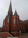
| 23 | Church of St. John the Baptist (Catholic) | 309 S. 3rd Ave. 47°31′13"N 92°32′4"W |
Virginia Virginia, Minnesota As of the census of 2000, there were 9,157 people, 4,333 households, and 2,270 families residing in the city. The population density was 486.1 people per square mile . There were 4,692 housing units at an average density of 249.1 per square mile... |
|||
| 24 | Church of St. Joseph (Catholic) | 7897 Elmer Rd. 47°5′1"N 92°46′36"W |
Elmer Elmer, Minnesota Elmer is an unincorporated community in Elmer Township, St. Louis County, Minnesota, United States.The community is located near Meadowlands at the junction of County Road 199 and County Road 193 .... |
|||
| 25 | Church of the Holy Family (Catholic) | 307 Adams Ave. 47°27′51"N 92°32′18"W |
Eveleth Eveleth, Minnesota As of the census of 2000, there were 3,865 people, 1,717 households, and 971 families residing in the city. The population density was 611.0 people per square mile . There were 1,965 housing units at an average density of 310.6 per square mile... |
|||
| 26 | Civilian Conservation Corps Camp S-52 | Off U.S. Route 53 U.S. Route 53 U.S. Route 53 is a north–south U.S. highway that runs for 403 miles from La Crosse, Wisconsin to northern Minnesota. It is the primary north–south route in northwestern Wisconsin, serving as a vital link between I-94 at Eau Claire, Wisconsin and the city of Duluth, Minnesota... 48°6′5"N 92°50′39"W |
Orr Orr, Minnesota Orr is a city in Saint Louis County, Minnesota, United States. The population was 267 at the 2010 census.U.S. Highway 53 serves as a main arterial route in the city.Orr is best known as an entry point for the Boundary Waters and Voyageurs National Park.... |
|||
| 27 | Coates House | 817 S. 5th Ave. 47°30′54"N 92°32′19"W |
Virginia Virginia, Minnesota As of the census of 2000, there were 9,157 people, 4,333 households, and 2,270 families residing in the city. The population density was 486.1 people per square mile . There were 4,692 housing units at an average density of 249.1 per square mile... |
|||
| 28 | Chester and Clara Congdon Estate Glensheen Historic Estate The Glensheen Historic Estate is a historic mansion on Lake Superior owned by the University of Minnesota Duluth. Glensheen sits on of lake front property, has 38 rooms and is built in the Jacobean architectural tradition, inspired by the Beaux-Arts styles of the era. The mansion was... |
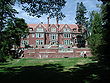 |
3300 London Rd. 46°48′59"N 92°3′10"W |
Duluth Duluth, Minnesota Duluth is a port city in the U.S. state of Minnesota and is the county seat of Saint Louis County. The fourth largest city in Minnesota, Duluth had a total population of 86,265 in the 2010 census. Duluth is also the second largest city that is located on Lake Superior after Thunder Bay, Ontario,... |
||
| 29 | Delvic Building | 1st Ave. and Howard St. 47°25′37"N 92°56′29"W |
Hibbing Hibbing, Minnesota Hibbing is a city in Saint Louis County, Minnesota, United States. The population was 16,361 at the 2010 census. The city was built on the rich iron ore of the Mesabi Iron Range. At the edge of town is the largest open-pit iron mine in the world. U.S... |
|||
| 30 | DeWitt-Seitz Building DeWitt-Seitz Building The DeWitt-Seitz Building is a building located in the Canal Park neighborhood of Duluth, Minnesota. The building was designed in 1909 in the commercial style popularized by Louis Sullivan. Its original tenant, the DeWitt-Seitz Company, was a furniture jobber and mattress manufacturer... |
 |
394 Lake Ave., S. 46°46′55"N 92°5′39"W |
Duluth Duluth, Minnesota Duluth is a port city in the U.S. state of Minnesota and is the county seat of Saint Louis County. The fourth largest city in Minnesota, Duluth had a total population of 86,265 in the 2010 census. Duluth is also the second largest city that is located on Lake Superior after Thunder Bay, Ontario,... |
||
| 31 | Duluth Central High School Central High School (Duluth, Minnesota) Central High School was a secondary school located in Duluth, Minnesota which educated students in grades nine through twelve. The school first opened in 1893. The mascot of the school was the Trojan... |
 |
Lake Ave. and 2nd St. 46°47′21"N 92°6′0"W |
Duluth Duluth, Minnesota Duluth is a port city in the U.S. state of Minnesota and is the county seat of Saint Louis County. The fourth largest city in Minnesota, Duluth had a total population of 86,265 in the 2010 census. Duluth is also the second largest city that is located on Lake Superior after Thunder Bay, Ontario,... |
||
| 32 | Duluth Armory | 1301-1305 London Rd. 46°47′55"N 92°4′50"W |
Duluth Duluth, Minnesota Duluth is a port city in the U.S. state of Minnesota and is the county seat of Saint Louis County. The fourth largest city in Minnesota, Duluth had a total population of 86,265 in the 2010 census. Duluth is also the second largest city that is located on Lake Superior after Thunder Bay, Ontario,... |
|||
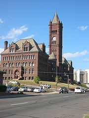
| 33 | Duluth Civic Center Historic District Duluth Civic Center Historic District Duluth Civic Center Historic District is a historic district in Duluth, Minnesota that includes three buildings: the St. Louis County Courthouse, designed by architect Daniel Burnham and built in 1908-1909; Duluth City Hall, designed by Thomas J. Shefchik built in 1928, and the Federal Building,... |
 |
5th Ave., W. and 1st St. 46°47′0"N 92°6′23"W |
Duluth Duluth, Minnesota Duluth is a port city in the U.S. state of Minnesota and is the county seat of Saint Louis County. The fourth largest city in Minnesota, Duluth had a total population of 86,265 in the 2010 census. Duluth is also the second largest city that is located on Lake Superior after Thunder Bay, Ontario,... |
||
| 34 | Duluth Commercial Historic District | 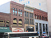 |
Superior and 1st between 4th Ave., W. and 4th Ave., E. 46°47′15"N 92°5′55"W |
Duluth Duluth, Minnesota Duluth is a port city in the U.S. state of Minnesota and is the county seat of Saint Louis County. The fourth largest city in Minnesota, Duluth had a total population of 86,265 in the 2010 census. Duluth is also the second largest city that is located on Lake Superior after Thunder Bay, Ontario,... |
||
| 35 | Duluth Missabe and Iron Range Depot (Endion) Duluth Missabe and Iron Range Depot (Endion) The Duluth, Missabe and Iron Range Endion Depot is a historic railroad depot in Duluth, Minnesota. The station was formerly located at the corner of South Street and 15th Avenue East, but due to the extension of Interstate 35 along the shore of Lake Superior in 1985, the building was relocated to... |
 |
1504 South St. 46°47′59"N 92°4′36"W |
Duluth Duluth, Minnesota Duluth is a port city in the U.S. state of Minnesota and is the county seat of Saint Louis County. The fourth largest city in Minnesota, Duluth had a total population of 86,265 in the 2010 census. Duluth is also the second largest city that is located on Lake Superior after Thunder Bay, Ontario,... |
||
| 36 | Duluth Public Library Duluth Public Library The Duluth Public Library is located in downtown Duluth, Minnesota. It is a part of the Arrowhead Library System and serves a population of 86,918.-Services:... |
 |
101 W. 2nd St. 46°47′14"N 92°6′7"W |
Duluth Duluth, Minnesota Duluth is a port city in the U.S. state of Minnesota and is the county seat of Saint Louis County. The fourth largest city in Minnesota, Duluth had a total population of 86,265 in the 2010 census. Duluth is also the second largest city that is located on Lake Superior after Thunder Bay, Ontario,... |
||
| 37 | Duluth South Breakwater Inner (Duluth Range Rear) Lighthouse | 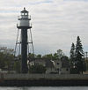 |
South Breakwater 46°46′43"N 92°5′31"W |
Duluth Duluth, Minnesota Duluth is a port city in the U.S. state of Minnesota and is the county seat of Saint Louis County. The fourth largest city in Minnesota, Duluth had a total population of 86,265 in the 2010 census. Duluth is also the second largest city that is located on Lake Superior after Thunder Bay, Ontario,... |
||
| 38 | Duluth State Normal School Historic District |  |
E. 5th St. 46°48′46"N 92°4′36"W |
Duluth Duluth, Minnesota Duluth is a port city in the U.S. state of Minnesota and is the county seat of Saint Louis County. The fourth largest city in Minnesota, Duluth had a total population of 86,265 in the 2010 census. Duluth is also the second largest city that is located on Lake Superior after Thunder Bay, Ontario,... |
||
| 39 | Duluth Union Depot | 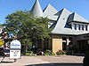 |
5th Ave., W. and Michigan St. 46°46′54"N 92°6′13"W |
Duluth Duluth, Minnesota Duluth is a port city in the U.S. state of Minnesota and is the county seat of Saint Louis County. The fourth largest city in Minnesota, Duluth had a total population of 86,265 in the 2010 census. Duluth is also the second largest city that is located on Lake Superior after Thunder Bay, Ontario,... |
||
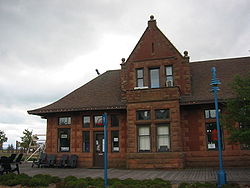
| 40 | Duluth, Winnipeg, and Pacific Depot | 600 Chestnut St. 47°31′24"N 92°32′27"W |
Virginia Virginia, Minnesota As of the census of 2000, there were 9,157 people, 4,333 households, and 2,270 families residing in the city. The population density was 486.1 people per square mile . There were 4,692 housing units at an average density of 249.1 per square mile... |
|||
| 41 | East Howard Street Commercial Historic District | 101-510 E. Howard St. 47°25′39"N 92°56′27"W |
Hibbing Hibbing, Minnesota Hibbing is a city in Saint Louis County, Minnesota, United States. The population was 16,361 at the 2010 census. The city was built on the rich iron ore of the Mesabi Iron Range. At the edge of town is the largest open-pit iron mine in the world. U.S... |
|||
| 42 | Endion School | 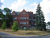 |
1801 E. 1st St. 46°48′19"N 92°4′37"W |
Duluth Duluth, Minnesota Duluth is a port city in the U.S. state of Minnesota and is the county seat of Saint Louis County. The fourth largest city in Minnesota, Duluth had a total population of 86,265 in the 2010 census. Duluth is also the second largest city that is located on Lake Superior after Thunder Bay, Ontario,... |
||
| 43 | Eveleth Manual Training Center | Roosevelt Ave. 47°27′51"N 92°31′59"W |
Eveleth Eveleth, Minnesota As of the census of 2000, there were 3,865 people, 1,717 households, and 971 families residing in the city. The population density was 611.0 people per square mile . There were 1,965 housing units at an average density of 310.6 per square mile... |
|||
| 44 | Eveleth Recreation Building | Garfield St. and Adams Ave. 47°27′53"N 92°32′29"W |
Eveleth Eveleth, Minnesota As of the census of 2000, there were 3,865 people, 1,717 households, and 971 families residing in the city. The population density was 611.0 people per square mile . There were 1,965 housing units at an average density of 310.6 per square mile... |
|||
| 45 | Finnish Sauna | 105 S. 1st St. 47°31′22"N 92°31′54"W |
Virginia Virginia, Minnesota As of the census of 2000, there were 9,157 people, 4,333 households, and 2,270 families residing in the city. The population density was 486.1 people per square mile . There were 4,692 housing units at an average density of 249.1 per square mile... |
|||
| 46 | Fire House No. 1 Fire Station No. 1 (Duluth, Minnesota) Fire House No. 1 stands as one of the first fire houses in the city of Duluth in the U.S. state of Minnesota. It is located on the north corner of 1st Avenue East and 3rd Street.... |
 |
Northwestern corner of 1st Ave., E. and 3rd St. 46°47′25"N 92°6′0"W |
Duluth Duluth, Minnesota Duluth is a port city in the U.S. state of Minnesota and is the county seat of Saint Louis County. The fourth largest city in Minnesota, Duluth had a total population of 86,265 in the 2010 census. Duluth is also the second largest city that is located on Lake Superior after Thunder Bay, Ontario,... |
||
| 47 | Fitger Brewing Company Fitger Brewing Company The Fitger's Brewing Company brewed beer from 1881 to 1972, making it Duluth's oldest continually-operating industry. The brewery was located at 600 East Superior Street, on Lake Superior in the U.S. state of Minnesota. The complex included ten buildings including the garage/stable , which was... |
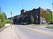 |
600 E. Superior St. 46°47′32"N 92°5′26"W |
Duluth Duluth, Minnesota Duluth is a port city in the U.S. state of Minnesota and is the county seat of Saint Louis County. The fourth largest city in Minnesota, Duluth had a total population of 86,265 in the 2010 census. Duluth is also the second largest city that is located on Lake Superior after Thunder Bay, Ontario,... |
||
| 48 | Flint Creek Farm Historic District | Minnesota Highway 1 Minnesota State Highway 1 Minnesota State Highway 1 is a highway in northwest and northeast Minnesota, which runs from North Dakota Highway 54 at the North Dakota state line and continues east to its eastern terminus at its intersection with Minnesota Highway 61 at the unincorporated town of Illgen City in Beaver Bay... 47°51′46"N 92°48′34"W |
Cook Cook, Minnesota Cook is a city in Saint Louis County, Minnesota, United States. The population was 574 at the 2010 census.U.S. Highway 53 and Minnesota Highway 1 are two of the main arterial routes in the community.... |
|||
| 49 | Jun Fujita Cabin | Eastern tip of Wendt Island, approximately 30 miles east of Ranier in Voyageurs National Park Voyageurs National Park Voyageurs National Park is a United States National Park in northern Minnesota near the town of International Falls. It was established in 1975. The park's name commemorates the voyageurs, French-Canadian fur traders who were the first European settlers to frequently travel through the area... 48°32′59"N 92°52′16"W |
Ranier Ranier, Minnesota Ranier is a city in Koochiching County, Minnesota, United States. The population was 145 at the 2010 census.-Geography:According to the United States Census Bureau, the city has a total area of , all of it land.-Demographics:... |
|||
| 50 | Gregorius and Mary Hanka Historic Farmstead | Off Township Road 6544 47°41′13"N 92°12′3"W |
Tower Tower, Minnesota As of the census of 2000, there are 479 people in the city, organized into 233 households and 137 families. The population density is 176.8 people per square mile . There are 295 housing units at an average density of 108.9 per square mile... |
|||
| 51 | Hartley Building |  |
740 E. Superior St. 47°41′39"N 92°4′20"W |
Duluth Duluth, Minnesota Duluth is a port city in the U.S. state of Minnesota and is the county seat of Saint Louis County. The fourth largest city in Minnesota, Duluth had a total population of 86,265 in the 2010 census. Duluth is also the second largest city that is located on Lake Superior after Thunder Bay, Ontario,... |
||
| 52 | Height of Land Portage | Off County Road 138 in Embarrass, White and Pike Townships 47°36′49"N 92°18′6"W |
Embarrass | |||
| 53 | Hibbing City Hall | 21st St., E. and 4th Ave. 47°25′36"N 92°56′14"W |
Hibbing Hibbing, Minnesota Hibbing is a city in Saint Louis County, Minnesota, United States. The population was 16,361 at the 2010 census. The city was built on the rich iron ore of the Mesabi Iron Range. At the edge of town is the largest open-pit iron mine in the world. U.S... |
|||
| 54 | Hibbing Disposal Plant | 1300 E. 23rd St. 47°25′31"N 92°54′55"W |
Hibbing Hibbing, Minnesota Hibbing is a city in Saint Louis County, Minnesota, United States. The population was 16,361 at the 2010 census. The city was built on the rich iron ore of the Mesabi Iron Range. At the edge of town is the largest open-pit iron mine in the world. U.S... |
|||
| 55 | Hibbing High School Hibbing High School Hibbing High School in Hibbing, Minnesota is a building listed on the National Register of Historic Places. As the Hull-Rust-Mahoning Mine expanded, iron ore was discovered under the existing town of Hibbing around 1918. The entire town of Hibbing was moved two miles south to make way for the... |
21st St. at 8th Ave. 47°25′31"N 92°55′57"W |
Hibbing Hibbing, Minnesota Hibbing is a city in Saint Louis County, Minnesota, United States. The population was 16,361 at the 2010 census. The city was built on the rich iron ore of the Mesabi Iron Range. At the edge of town is the largest open-pit iron mine in the world. U.S... |
|||
| 56 | Matt and Emma Hill Historic Farmstead | Off Township Road 303 47°39′18"N 92°19′51"W |
Tower Tower, Minnesota As of the census of 2000, there are 479 people in the city, organized into 233 households and 137 families. The population density is 176.8 people per square mile . There are 295 housing units at an average density of 108.9 per square mile... |
|||
| 57 | Hotel Glode | 222 Adams Ave. 47°27′53"N 92°32′16"W |
Eveleth Eveleth, Minnesota As of the census of 2000, there were 3,865 people, 1,717 households, and 971 families residing in the city. The population density was 611.0 people per square mile . There were 1,965 housing units at an average density of 310.6 per square mile... |
|||
| 58 | Hull-Rust-Mahoning Open Pit Iron Mine Hull-Rust-Mahoning Open Pit Iron Mine The Hull-Rust-Mahoning Mine in Hibbing, Minnesota, is one of the largest open pit iron mines in the world. The mine, located in the Mesabi Range, supplied as much as one-fourth of all the iron ore mined in the United States during its peak production during World War I and World War II.This area of... |
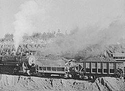 |
3rd Ave., E. 47°27′10"N 92°57′40"W |
Hibbing Hibbing, Minnesota Hibbing is a city in Saint Louis County, Minnesota, United States. The population was 16,361 at the 2010 census. The city was built on the rich iron ore of the Mesabi Iron Range. At the edge of town is the largest open-pit iron mine in the world. U.S... |
||
| 59 | William Ingersoll Estate | Ingersoll's Island 48°21′17"N 92°28′25"W |
Crane Lake Crane Lake, Minnesota Crane Lake is an unincorporated community in Crane Lake Township, St. Louis County, Minnesota, United States. It lies along County Road 24 in the Kabetogama State Forest.... vicinity |
Tourism and Recreational Properties in Voyageurs National Park 1880-1950 MPS | ||
| 60 | Irving School |  |
101 N. 56th Ave. W. 46°44′8"N 92°10′6"W |
Duluth Duluth, Minnesota Duluth is a port city in the U.S. state of Minnesota and is the county seat of Saint Louis County. The fourth largest city in Minnesota, Duluth had a total population of 86,265 in the 2010 census. Duluth is also the second largest city that is located on Lake Superior after Thunder Bay, Ontario,... |
||
| 61 | Jukola Boardinghouse | 201 N. 3rd Ave. 47°31′31"N 92°32′3"W |
Virginia Virginia, Minnesota As of the census of 2000, there were 9,157 people, 4,333 households, and 2,270 families residing in the city. The population density was 486.1 people per square mile . There were 4,692 housing units at an average density of 249.1 per square mile... |
|||
| 62 | Kabetogama Ranger Station District | Southwestern shore of Kabetogama Lake in Voyageurs National Park Voyageurs National Park Voyageurs National Park is a United States National Park in northern Minnesota near the town of International Falls. It was established in 1975. The park's name commemorates the voyageurs, French-Canadian fur traders who were the first European settlers to frequently travel through the area... 48°26′43"N 93°1′47"W |
Ray Ray, Minnesota Ray is an unincorporated community in Koochiching County, Minnesota, United States.The community is located southeast of International Falls at the junction of U.S. Route 53 and Minnesota State Highway 217.-Further reading:... |
|||
| 63 | Kettle Falls Historic District Kettle Falls Historic District The Kettle Falls Historic District encompasses a portage site on the United States-Canadian border in Voyageurs National Park, Minnesota. Kettle Falls is a drainage channel between Namakan Lake and Rainy Lake on the United States side of the border on the eastern end of the Kabetogama peninsula... |
Kettle Channel in Voyageurs National Park Voyageurs National Park Voyageurs National Park is a United States National Park in northern Minnesota near the town of International Falls. It was established in 1975. The park's name commemorates the voyageurs, French-Canadian fur traders who were the first European settlers to frequently travel through the area... 48°30′5"N 92°38′25"W |
Island View Island View, Minnesota Island View is an unincorporated community in Koochiching County, Minnesota, United States.The community is located east of International Falls at Rainy Lake on Minnesota State Highway 11.-Further reading:... |
|||
| 64 | Kettle Falls Hotel Kettle Falls Hotel The Kettle Falls Hotel is a hotel that was built beginning in 1910 in what is now Voyageurs National Park on the Kabetogama Peninsula, at the juncture of Namakan and Rainy Lakes. The hotel was built to replace temporary lodgings, accommodating dam workers, loggers and tourists, and was finally... |
Kettle Channel in Voyageurs National Park Voyageurs National Park Voyageurs National Park is a United States National Park in northern Minnesota near the town of International Falls. It was established in 1975. The park's name commemorates the voyageurs, French-Canadian fur traders who were the first European settlers to frequently travel through the area... 48°30′11"N 92°38′23"W |
Island View Island View, Minnesota Island View is an unincorporated community in Koochiching County, Minnesota, United States.The community is located east of International Falls at Rainy Lake on Minnesota State Highway 11.-Further reading:... |
|||
| 65 | Kitchi Gammi Club |  |
831 E. Superior St. 46°47′44"N 92°5′16"W |
Duluth Duluth, Minnesota Duluth is a port city in the U.S. state of Minnesota and is the county seat of Saint Louis County. The fourth largest city in Minnesota, Duluth had a total population of 86,265 in the 2010 census. Duluth is also the second largest city that is located on Lake Superior after Thunder Bay, Ontario,... |
||
| 66 | LeMoine Building | Off County Highway 74 47°58′7"N 92°49′24"W |
Orr Orr, Minnesota Orr is a city in Saint Louis County, Minnesota, United States. The population was 267 at the 2010 census.U.S. Highway 53 serves as a main arterial route in the city.Orr is best known as an entry point for the Boundary Waters and Voyageurs National Park.... |
|||
| 67 | Charles Lenont House | 202 N. 5th Ave. 47°31′31"N 92°32′20"W |
Virginia Virginia, Minnesota As of the census of 2000, there were 9,157 people, 4,333 households, and 2,270 families residing in the city. The population density was 486.1 people per square mile . There were 4,692 housing units at an average density of 249.1 per square mile... |
|||
| 68 | Lester River Bridge-Bridge No. 5772 |  |
London Rd. over the Lester River Lester River The Lester River, is a short tributary of Lake Superior, about 15 mi long, in northeastern Minnesota in the United States. It drains an area of 58 sq mi .-Course:... 46°50′12"N 92°0′22"W |
Duluth Duluth, Minnesota Duluth is a port city in the U.S. state of Minnesota and is the county seat of Saint Louis County. The fourth largest city in Minnesota, Duluth had a total population of 86,265 in the 2010 census. Duluth is also the second largest city that is located on Lake Superior after Thunder Bay, Ontario,... |
||
| 69 | Lincoln School Building | 3rd Ave. 47°31′28"N 92°32′2"W |
Virginia Virginia, Minnesota As of the census of 2000, there were 9,157 people, 4,333 households, and 2,270 families residing in the city. The population density was 486.1 people per square mile . There were 4,692 housing units at an average density of 249.1 per square mile... |
|||
| 70 | Adolph Levin Cottage | Kabetogama Narrows near Ash River Maintenance Dock | Kabetogama Lake vicinity | Tourism and Recreational Properties in Voyageurs National Park 1880-1950 MPS | ||
| 71 | Listening Point | 3128 Listening Point Rd. 47°54′10.52"N 92°0′50.48"W |
Ely Ely, Minnesota As of the census of 2000, there were 3,724 people, 1,912 households, and 916 families residing in the city. The population density was 1,369.5 people per square mile . There were 1,912 housing units at an average density of 703.2 per square mile... |
|||
| 72 | E.J. Longyear First Diamond Drill Site | Off County Highway 110 47°33′25"N 92°7′4"W |
Hoyt Lakes Hoyt Lakes, Minnesota Hoyt Lakes is a city in Saint Louis County, Minnesota, United States. The population was 2,017 at the 2010 census.County Highway 110 serves as a main arterial route in the community.-Geography:... |
|||
| 73 | Mike and Mary Matson Historic Farmstead | Off County Highway 21 47°40′47"N 92°12′12"W |
Tower Tower, Minnesota As of the census of 2000, there are 479 people in the city, organized into 233 households and 137 families. The population density is 176.8 people per square mile . There are 295 housing units at an average density of 108.9 per square mile... |
|||
| 74 | Minnesota Point Lighthouse | On Minnesota Point Minnesota Point Minnesota Point, also known as the Park Point neighborhood of Duluth, Minnesota, United States; is a long, narrow sand spit that extends out from the Canal Park tourist recreation-oriented district of the city of Duluth... 46°42′37"N 92°1′32"W |
Duluth Duluth, Minnesota Duluth is a port city in the U.S. state of Minnesota and is the county seat of Saint Louis County. The fourth largest city in Minnesota, Duluth had a total population of 86,265 in the 2010 census. Duluth is also the second largest city that is located on Lake Superior after Thunder Bay, Ontario,... |
Drawings here | ||
| 75 | Mitchell-Tappan House | 2145 4th Ave. 47°25′31"N 92°56′18"W |
Hibbing Hibbing, Minnesota Hibbing is a city in Saint Louis County, Minnesota, United States. The population was 16,361 at the 2010 census. The city was built on the rich iron ore of the Mesabi Iron Range. At the edge of town is the largest open-pit iron mine in the world. U.S... |
|||
| 76 | Bergetta Moe Bakery |  |
716 E. Superior St. 46°47′33"N 92°5′26"W |
Duluth Duluth, Minnesota Duluth is a port city in the U.S. state of Minnesota and is the county seat of Saint Louis County. The fourth largest city in Minnesota, Duluth had a total population of 86,265 in the 2010 census. Duluth is also the second largest city that is located on Lake Superior after Thunder Bay, Ontario,... |
||
| 77 | Monson's Hoist Bay Resort | Hoist Bay | Namakan Lake vicinity | Tourism and Recreational Properties in Voyageurs National Park 1880-1950 MPS | ||
| 78 | Mountain Iron Mine Mountain Iron Mine The discovery of Mountain Iron Mine in Mountain Iron, Minnesota in 1890 represents the beginning of the exploitation of the Mesabi Range iron ore in the Iron Range of northeast Minnesota. The Mesabi Range and nearby Vermilion Range led Minnesota to become the nation's largest producer of iron ore... |
 |
North of Mountain Iron 47°32′20"N 92°37′25"W |
Mountain Iron Mountain Iron, Minnesota As of the census of 2000, there were 2,999 people, 1,326 households, and 847 families residing in the city. The population density was 60.7 people per square mile . There were 1,409 housing units at an average density of 28.5 per square mile... |
||
| 79 | Munger Terrace Munger Terrace Munger Terrace is a landmarked apartment block in Duluth, Minnesota, USA. It was originally eight luxury townhouses.The building, in brick with brownstone trim, was constructed in 1891-92 for Roger S. Munger, an important early Duluth entrepreneur, on a site next to his Victorian Gothic mansion;... |
 |
405 Mesabi Ave. 46°47′9"N 92°6′33"W |
Duluth Duluth, Minnesota Duluth is a port city in the U.S. state of Minnesota and is the county seat of Saint Louis County. The fourth largest city in Minnesota, Duluth had a total population of 86,265 in the 2010 census. Duluth is also the second largest city that is located on Lake Superior after Thunder Bay, Ontario,... |
||
| 80 | Erick and Kristina Nelimark Saunaa | Junction of Township Roads 21 and 615 47°39′46"N 92°11′45"W |
Tower Tower, Minnesota As of the census of 2000, there are 479 people in the city, organized into 233 households and 137 families. The population density is 176.8 people per square mile . There are 295 housing units at an average density of 108.9 per square mile... |
|||
| 81 | Northland | Off U.S. Route 2 U.S. Route 2 U.S. Route 2 is an east–west U.S. Highway spanning across the northern continental United States. US 2 consists of two segments connected by various roadways in southern Canada... 46°44′45"N 92°13′34"W |
Proctor Proctor, Minnesota As of the census of 2000, there were 2,852 people, 1,196 households, and 772 families residing in the city. The population density was 942.8 people per square mile . There were 1,246 housing units at an average density of 411.9 per square mile... |
|||
| 82 | Orr Roadside Parking Area | Minnesota Highway 53 at First Ave. 48°4′5"N 92°49′51"W |
Orr Orr, Minnesota Orr is a city in Saint Louis County, Minnesota, United States. The population was 267 at the 2010 census.U.S. Highway 53 serves as a main arterial route in the city.Orr is best known as an entry point for the Boundary Waters and Voyageurs National Park.... |
|||
| 83 | Pioneer Mine Buildings and A Headframe |  |
Off Pioneer Rd. 47°54′44"N 91°51′37"W |
Ely Ely, Minnesota As of the census of 2000, there were 3,724 people, 1,912 households, and 916 families residing in the city. The population density was 1,369.5 people per square mile . There were 1,912 housing units at an average density of 703.2 per square mile... |
||
| 84 | Anna and Mikko Pyhala Farm | 4745 Salo Rd. 47°39′46"N 92°11′8"W |
Embarrass | |||
| 85 | Sacred Heart Cathedral, Sacred Heart School and Christian Brothers Home Sacred Heart Cathedral, Sacred Heart School and Christian Brothers Home Sacred Heart Cathedral, Sacred Heart School and Christian Brothers in Duluth, Minnesota is listed on the U.S. National Register of Historic Places. It was first listed as Sacred Heart Cathedral and Cathedral School in 1986, and its boundaries were increased and it was renamed in 2005.The building... |
 |
(original) (increase) |
206 and 211 W. Fourth St. (original); 315 N. 2nd Ave., W. (increase) 46°47′15"N 92°6′20"W |
Duluth Duluth, Minnesota Duluth is a port city in the U.S. state of Minnesota and is the county seat of Saint Louis County. The fourth largest city in Minnesota, Duluth had a total population of 86,265 in the 2010 census. Duluth is also the second largest city that is located on Lake Superior after Thunder Bay, Ontario,... |
|
| 86 | St. Louis County 4-H Club Camp | 100 Pine Lane 47°28′27"N 92°20′47"W |
Gilbert Gilbert, Minnesota As of the census of 2000, there were 1,847 people, 842 households, and 495 families residing in the city. The population density was 156.7 people per square mile . There were 900 housing units at an average density of 76.3 per square mile... |
|||
| 87 | St. Louis County District Courthouse | 300 S. 5th Ave. 47°31′15"N 92°32′16"W |
Virginia Virginia, Minnesota As of the census of 2000, there were 9,157 people, 4,333 households, and 2,270 families residing in the city. The population density was 486.1 people per square mile . There were 4,692 housing units at an average density of 249.1 per square mile... |
|||
| 88 | St. Mark's African Methodist Episcopal Church |  |
530 N. 5th Ave. E. 46°47′47"N 92°5′45"W |
Duluth Duluth, Minnesota Duluth is a port city in the U.S. state of Minnesota and is the county seat of Saint Louis County. The fourth largest city in Minnesota, Duluth had a total population of 86,265 in the 2010 census. Duluth is also the second largest city that is located on Lake Superior after Thunder Bay, Ontario,... |
||
| 89 | Saints Peter and Paul Church-Ukrainian Catholic | 530 Central Ave. 47.483514°N 92.878852°W |
Chisholm Chisholm, Minnesota As of the census of 2000, there were 4,960 people, 2,178 households, and 1,287 families residing in the city. The population density was 1,129 people per square mile . There were 2,375 housing units at an average density of 540/sq mi... |
|||
| 90 | Alex Seitaniemi Housebarn Alex Seitaniemi Housebarn The Alex Seitaniemi Housebarn is a housebarn in Waasa Township, St. Louis County, near Tower, Minnesota. It is listed on the National Register of Historic Places. Combining the house and barn in one building provided advantages. The heat from livestock kept the house warm, and constructing one... |
Off Township Road 797 47°42′25"N 92°8′15"W |
Tower Tower, Minnesota As of the census of 2000, there are 479 people in the city, organized into 233 households and 137 families. The population density is 176.8 people per square mile . There are 295 housing units at an average density of 108.9 per square mile... |
|||
| 91 | Sons of Italy Hall | 704 E. Howard St. 47°25′38"N 92°55′59"W |
Hibbing Hibbing, Minnesota Hibbing is a city in Saint Louis County, Minnesota, United States. The population was 16,361 at the 2010 census. The city was built on the rich iron ore of the Mesabi Iron Range. At the edge of town is the largest open-pit iron mine in the world. U.S... |
|||
| 92 | Soudan Iron Mine Soudan Underground Mine State Park The Soudan Underground Mine State Park is a Minnesota state park at the site of the Soudan Underground Mine, on the south shore of Lake Vermilion. The mine is known as Minnesota's oldest, deepest, and richest iron mine, and now hosts the Soudan Underground Laboratory. As the Soudan Iron Mine, it... |
 |
Tower-Soudan State Park 47°49′24"N 92°14′14"W |
Tower Tower, Minnesota As of the census of 2000, there are 479 people in the city, organized into 233 households and 137 families. The population density is 176.8 people per square mile . There are 295 housing units at an average density of 108.9 per square mile... |
||
| 93 | I.W. Stevens Lakeside Cottage | Williams Island | Namakan Lake vicinity | Tourism and Recreational Properties in Voyageurs National Park 1880-1950 MPS | ||
| 94 | Stuntz Bay Boathouse Historic District | At the northern end of Stuntz Bay Rd. 47°49′33.69"N 92°14′10.63"W |
Breitung Township | |||
| 95 | Tanner's Hospital | 204 E. Camp St. 47°54′17"N 91°51′43"W |
Ely Ely, Minnesota As of the census of 2000, there were 3,724 people, 1,912 households, and 916 families residing in the city. The population density was 1,369.5 people per square mile . There were 1,912 housing units at an average density of 703.2 per square mile... |
|||
| 96 | Waino Tanttari Field Hay Barn | End of Township Road 585 47°42′39"N 92°9′42"W |
Tower Tower, Minnesota As of the census of 2000, there are 479 people in the city, organized into 233 households and 137 families. The population density is 176.8 people per square mile . There are 295 housing units at an average density of 108.9 per square mile... |
|||
| 97 | ROBERT WALLACE (bulk carrier) shipwreck site | Address restricted | Palmers Palmers, Minnesota Palmers is an unincorporated community in Duluth Township, Saint Louis County, Minnesota, United States.The community is located 16 miles northeast of the city of Duluth, near the junction of North Shore Scenic Drive and County Road 42 .... |
|||
| 98 | THOMAS WILSON (Whaleback Freighter) Shipwreck Thomas Wilson (shipwreck) The Thomas Wilson was a whaleback freighter built in 1892 and used to haul bulk freight on the Great Lakes. The ship sank in the harbor of Duluth, Minnesota, on Lake Superior, on 7 June 1902, after a collision with the George Hadley... |
 |
Address Restricted | Duluth Duluth, Minnesota Duluth is a port city in the U.S. state of Minnesota and is the county seat of Saint Louis County. The fourth largest city in Minnesota, Duluth had a total population of 86,265 in the 2010 census. Duluth is also the second largest city that is located on Lake Superior after Thunder Bay, Ontario,... |
||
| 99 | Tower Fire Hall | Main St. 47°48′19"N 92°16′29"W |
Tower Tower, Minnesota As of the census of 2000, there are 479 people in the city, organized into 233 households and 137 families. The population density is 176.8 people per square mile . There are 295 housing units at an average density of 108.9 per square mile... |
|||
| 100 | Oliver G. Traphagen House Oliver G. Traphagen House The Oliver G. Traphagen House is a house in Duluth, Minnesota. The architect, Oliver G. Traphagen, designed a number of buildings in Duluth, as well as in Hawaii. The house is a three-story Victorian mansion. The front wall is built of local red sandstone and features ornate carving and window... |
 |
1509-1511 E. Superior St. 46°48′7"N 92°4′46"W |
Duluth Duluth, Minnesota Duluth is a port city in the U.S. state of Minnesota and is the county seat of Saint Louis County. The fourth largest city in Minnesota, Duluth had a total population of 86,265 in the 2010 census. Duluth is also the second largest city that is located on Lake Superior after Thunder Bay, Ontario,... |
||
| 101 | United States Army Corps of Engineers Duluth Vessel Yard U.S. Army Corps of Engineers Vessel Yard The U.S. Army Corps of Engineers Vessel Yard in the U.S. city of Duluth was constructed between Lake Superior and Duluth's harbor, midway between Duluth and Superior, Wisconsin.-History:... |
 |
Junction of 9th St., S. and Minnesota Ave. 46°46′32"N 92°5′34"W |
Duluth Duluth, Minnesota Duluth is a port city in the U.S. state of Minnesota and is the county seat of Saint Louis County. The fourth largest city in Minnesota, Duluth had a total population of 86,265 in the 2010 census. Duluth is also the second largest city that is located on Lake Superior after Thunder Bay, Ontario,... |
||
| 102 | US Fisheries Station, Duluth |  |
6008 London Rd. 46°50′10"N 92°0′22"W |
Duluth Duluth, Minnesota Duluth is a port city in the U.S. state of Minnesota and is the county seat of Saint Louis County. The fourth largest city in Minnesota, Duluth had a total population of 86,265 in the 2010 census. Duluth is also the second largest city that is located on Lake Superior after Thunder Bay, Ontario,... |
||
| 103 | USS ESSEX Shipwreck Site USS Essex (1876) |-External links:*... |
Address Restricted | Duluth Duluth, Minnesota Duluth is a port city in the U.S. state of Minnesota and is the county seat of Saint Louis County. The fourth largest city in Minnesota, Duluth had a total population of 86,265 in the 2010 census. Duluth is also the second largest city that is located on Lake Superior after Thunder Bay, Ontario,... |
|||
| 104 | Valon Tuote Raittiusseura | 125 3rd St., N. 47°31′35"N 92°31′57"W |
Virginia Virginia, Minnesota As of the census of 2000, there were 9,157 people, 4,333 households, and 2,270 families residing in the city. The population density was 486.1 people per square mile . There were 4,692 housing units at an average density of 249.1 per square mile... |
|||
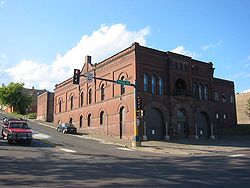
| 105 | Virginia Brewery | 305 S. 7th Ave. 47°31′16"N 92°32′33"W |
Virginia Virginia, Minnesota As of the census of 2000, there were 9,157 people, 4,333 households, and 2,270 families residing in the city. The population density was 486.1 people per square mile . There were 4,692 housing units at an average density of 249.1 per square mile... |
|||
| 106 | Virginia City Hall | 327 1st St., S. 47°31′20"N 92°32′8"W |
Virginia Virginia, Minnesota As of the census of 2000, there were 9,157 people, 4,333 households, and 2,270 families residing in the city. The population density was 486.1 people per square mile . There were 4,692 housing units at an average density of 249.1 per square mile... |
|||
| 107 | Virginia Commercial Historic District | Chestnut St. between 1st and 6th Aves. 47°31′22"N 92°32′7"W |
Virginia Virginia, Minnesota As of the census of 2000, there were 9,157 people, 4,333 households, and 2,270 families residing in the city. The population density was 486.1 people per square mile . There were 4,692 housing units at an average density of 249.1 per square mile... |
|||
| 108 | Virginia Recreation Building | 305 S. 1st St. 47°31′21"N 92°32′7"W |
Virginia Virginia, Minnesota As of the census of 2000, there were 9,157 people, 4,333 households, and 2,270 families residing in the city. The population density was 486.1 people per square mile . There were 4,692 housing units at an average density of 249.1 per square mile... |
|||
| 109 | Virginia-Rainy Lake Lumber Company Manager's Residence | 402 and 404 S. 5th Ave. 47°31′10"N 92°32′17"W |
Virginia Virginia, Minnesota As of the census of 2000, there were 9,157 people, 4,333 households, and 2,270 families residing in the city. The population density was 486.1 people per square mile . There were 4,692 housing units at an average density of 249.1 per square mile... |
|||
| 110 | Virginia-Rainy Lake Lumber Company Office | 731 3rd St., S. 47°31′15"N 92°32′37"W |
Virginia Virginia, Minnesota As of the census of 2000, there were 9,157 people, 4,333 households, and 2,270 families residing in the city. The population density was 486.1 people per square mile . There were 4,692 housing units at an average density of 249.1 per square mile... |
|||
| 111 | Western Bohemian Fraternal Union Hall Western Bohemian Fraternal Union Hall The Western Bohemian Fraternal Union Hall is an historic building located in Meadowlands, Minnesota that was built in 1925. It was listed on the National Register of Historic Places on July 31, 1986. The building historically served as a meeting hall for the Czech community and hosted a ZCBJ lodge... |
County Highway 29 47°2′53"N 92°44′44"W |
Meadowlands Meadowlands, Minnesota Meadowlands is a city in Saint Louis County, Minnesota, United States. The population was 134 at the 2010 census.County Highway 133 and County Highway 5 are two of the main arterial routes in the community.-History:... |
|||
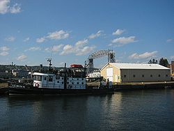
| 112 | WILLIAM A. IRVIN (freighter) William A. Irvin The SS William A. Irvin is a lake freighter which sailed as a bulk freighter on the Great Lakes as part US Steel's lake fleet. She was flagship of the company fleet from her launch in the depths of the depression in 1938 until 1975 and then as a general workhorse of the fleet until her retirement... |
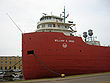 |
Minnesota Slip in Duluth Harbor 46°47′0"N 92°5′51"W |
Duluth Duluth, Minnesota Duluth is a port city in the U.S. state of Minnesota and is the county seat of Saint Louis County. The fourth largest city in Minnesota, Duluth had a total population of 86,265 in the 2010 census. Duluth is also the second largest city that is located on Lake Superior after Thunder Bay, Ontario,... |
||
| 113 | Wirth Building |  |
13 W. Superior St. 46°47′13"N 92°5′56"W |
Duluth Duluth, Minnesota Duluth is a port city in the U.S. state of Minnesota and is the county seat of Saint Louis County. The fourth largest city in Minnesota, Duluth had a total population of 86,265 in the 2010 census. Duluth is also the second largest city that is located on Lake Superior after Thunder Bay, Ontario,... |
||
| 114 | YWCA of Duluth | 202 W. 2nd St. 46°47′11"N 92°6′11"W |
Duluth Duluth, Minnesota Duluth is a port city in the U.S. state of Minnesota and is the county seat of Saint Louis County. The fourth largest city in Minnesota, Duluth had a total population of 86,265 in the 2010 census. Duluth is also the second largest city that is located on Lake Superior after Thunder Bay, Ontario,... |
Duluth's Central Business District MPS |
External links
- A list of the above sites, with street addresses and other information, is available at St. Louis County, MN listing of National Register of Historic Places.com, a private site serving up NRHP information.