
Minnesota Point
Encyclopedia

Neighborhoods of Duluth, Minnesota
The city of Duluth, overlooking Lake Superior in the U.S. state of Minnesota has several distinct neighborhoods.- Central :*Canal Park*Central Hillside*Downtown Duluth*East Hillside*Park Point- Eastern Duluth :*Chester Park / UMD*Congdon Park...
of Duluth
Duluth, Minnesota
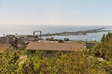
Duluth is a port city in the U.S. state of Minnesota and is the county seat of Saint Louis County. The fourth largest city in Minnesota, Duluth had a total population of 86,265 in the 2010 census. Duluth is also the second largest city that is located on Lake Superior after Thunder Bay, Ontario,...
, Minnesota
Minnesota
Minnesota is a U.S. state located in the Midwestern United States. The twelfth largest state of the U.S., it is the twenty-first most populous, with 5.3 million residents. Minnesota was carved out of the eastern half of the Minnesota Territory and admitted to the Union as the thirty-second state...
, United States
United States
The United States of America is a federal constitutional republic comprising fifty states and a federal district...
; is a long, narrow sand spit
Spit (landform)
A spit or sandspit is a deposition landform found off coasts. At one end, spits connect to land, and extend into the sea. A spit is a type of bar or beach that develops where a re-entrant occurs, such as at cove's headlands, by the process of longshore drift...
that extends out from the Canal Park
Canal Park (Duluth)
Canal Park is a tourist and recreation-oriented district of Duluth, Minnesota, United States. Situated across the Interstate 35 freeway from Downtown Duluth, it is connected by the famous Aerial Lift Bridge to the Park Point sandbar and neighborhood...
tourist recreation-oriented district of the city of Duluth. The Point separates Lake Superior
Lake Superior
Lake Superior is the largest of the five traditionally-demarcated Great Lakes of North America. It is bounded to the north by the Canadian province of Ontario and the U.S. state of Minnesota, and to the south by the U.S. states of Wisconsin and Michigan. It is the largest freshwater lake in the...
from Superior Bay
Superior Bay
Superior Bay is a narrow inlet of Lake Superior along the border of Minnesota and Wisconsin. It is 7 miles long and 0.5 miles wide. A small strait connects it to St. Louis Bay and Spirit Lake to the west, into which the St Louis River empties....
and the Duluth Harbor Basin.
Lake Avenue South / Minnesota Avenue serves as a main arterial route in the community.
Near the end of Minnesota Point is a small airport, Sky Harbor Airport. Beyond the airport, approximately 3/4 mile, is an old growth red and white pine forest. Within the forest is a Minnesota Department of Natural Resources
Minnesota Department of Natural Resources
The Minnesota Department of Natural Resources is the agency of the U.S. state of Minnesota charged with conserving and managing the state's natural resources. The agency maintains areas such as state parks, state forests, recreational trails, and recreation areas as well as managing minerals,...
designated area, the Minnesota Point Pine Forest Scientific and Natural Area, which encompasses 18 acres .
Minnesota Point is approximately 7 miles in length, and when included with adjacent Wisconsin Point
Wisconsin Point
Wisconsin Point is a peninsula off the shore of Superior, Wisconsin, in Douglas County, Wisconsin. It is 3 miles in length. The Wisconsin Point Lighthouse was built in 1913 and is located on the end of the peninsula. It is owned and maintained by the city of Superior...
, which extends 3 miles out from the city of Superior
Superior, Wisconsin
Superior is a city in and the county seat of Douglas County, Wisconsin, United States. The population was 26,960 at the 2010 census. Located at the junction of U.S. Highways 2 and 53, it is north of and adjacent to both the Village of Superior and the Town of Superior.Superior is at the western...
, Wisconsin
Wisconsin
Wisconsin is a U.S. state located in the north-central United States and is part of the Midwest. It is bordered by Minnesota to the west, Iowa to the southwest, Illinois to the south, Lake Michigan to the east, Michigan to the northeast, and Lake Superior to the north. Wisconsin's capital is...
, is reported to be the largest freshwater sandbar
Shoal
Shoal, shoals or shoaling may mean:* Shoal, a sandbank or reef creating shallow water, especially where it forms a hazard to shipping* Shoal draught , of a boat with shallow draught which can pass over some shoals: see Draft...
in the world at a total of 10 miles.
History
Due to the short and easy portage across Minnesota Point, the Ojibwa name for the city of Duluth is Onigamiinsing ("at the little portage").In the 1850's, the St. Louis River was established as the border between neighboring states Minnesota and Wisconsin and the two ports Duluth (Minnesota) and Superior (Wisconsin) became fierce economic competitors for shipping traffic off of Lake Superior. As commercial traffic on Lake Superior increased with the completion of the Sault Ste Marie canal connecting Lake Superior to Lake Michigan, Congress appropriated the funds to build a lighthouse on the narrow opening in Minnesota Point, known as Superior Entry. The lighthouse built between 1855 and 1858 was the first to use RH Barret's Fifth Order Fresnel lamp and Barret became the stations first lighthouse keeper, succeeded in 1861 by Samuel Stewart Palmer. This lighthouse was affectionately known by the name, "The Old Standby".
Since the digging of an artificial canal
Canal
Canals are man-made channels for water. There are two types of canal:#Waterways: navigable transportation canals used for carrying ships and boats shipping goods and conveying people, further subdivided into two kinds:...
in 1870–1871, Minnesota Point is technically an island, connected to the rest of the city of Duluth since 1905 by the Aerial Lift Bridge
Aerial Lift Bridge
The Aerial Lift Bridge is a major landmark in the port city of Duluth, Minnesota. The span is a vertical lift bridge, which is rather uncommon, but it began life as an extremely rare transporter bridge—the first of just two such bridges ever constructed in the United States...
.
Adjacent neighborhoods
- Canal ParkCanal Park (Duluth)Canal Park is a tourist and recreation-oriented district of Duluth, Minnesota, United States. Situated across the Interstate 35 freeway from Downtown Duluth, it is connected by the famous Aerial Lift Bridge to the Park Point sandbar and neighborhood...
and Downtown DuluthDowntown DuluthThe Downtown of Duluth, Minnesota, United States; is situated between Mesaba Avenue and 4th Avenue East; and located on Michigan, Superior, First, Second, and Third Streets.The downtown area is easily accessible from Interstate Highway 35....
to the immediate north