

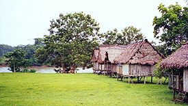
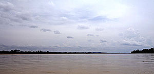
Napo River
Encyclopedia
Tributary
A tributary or affluent is a stream or river that flows into a main stem river or a lake. A tributary does not flow directly into a sea or ocean...
to the Amazon River
Amazon River
The Amazon of South America is the second longest river in the world and by far the largest by waterflow with an average discharge greater than the next seven largest rivers combined...
that rises in Ecuador
Ecuador
Ecuador , officially the Republic of Ecuador is a representative democratic republic in South America, bordered by Colombia on the north, Peru on the east and south, and by the Pacific Ocean to the west. It is one of only two countries in South America, along with Chile, that do not have a border...
on the flanks of the volcano
Volcano
2. Bedrock3. Conduit 4. Base5. Sill6. Dike7. Layers of ash emitted by the volcano8. Flank| 9. Layers of lava emitted by the volcano10. Throat11. Parasitic cone12. Lava flow13. Vent14. Crater15...
es of Antisana
Antisana
Antisana is a stratovolcano of the northern Andes, in Ecuador. It is the fourth highest volcano in Ecuador, at , and is located 50 km SE of the capital city of Quito.Antisana presents one of the most challenging technical climbs in the Ecuadorian Andes....
, Sincholagua and Cotopaxi
Cotopaxi
Cotopaxi is a stratovolcano in the Andes Mountains, located about south of Quito, Ecuador, South America. It is the second highest summit in the country, reaching a height of...
.
The total length of 1075 km. Catchment area of 100,518 square kilometers. Mean annual discharge 6,976 cubic meters per second.
Before it reaches the plains it receives a great number of small streams from impenetrable, saturated and much broken mountainous districts, where the dense and varied vegetation seems to fight for every piece of ground. This river is one of Ecuador's Physical Features. From the north it is joined by the river Coca
Coca River
The Coca River is a river in eastern Ecuador. It is a tributary of the Napo River. The two rivers join in Puerto Francisco de Orellana....
, having its sources in the gorges of Cayambe (volcano)
Cayambe (volcano)
Cayambe is the name of a volcano located in the Cordillera Oriental, a branch of the Ecuadorian Andes. It is located in Pichincha province some 70 km northeast of Quito. It is the third highest mountain in Ecuador....
on the equator
Equator
An equator is the intersection of a sphere's surface with the plane perpendicular to the sphere's axis of rotation and containing the sphere's center of mass....
, and also a powerful river, the Aguarico
Aguarico River
The Aguarico River is a river in northern Ecuador. It is the main river of the Sucumbíos province. In the last part of its course it is the Ecuadorian-Peruvian border. It empties into the Napo River...
, having its headwaters between Cayambe and the Colombia
Colombia
Colombia, officially the Republic of Colombia , is a unitary constitutional republic comprising thirty-two departments. The country is located in northwestern South America, bordered to the east by Venezuela and Brazil; to the south by Ecuador and Peru; to the north by the Caribbean Sea; to the...
n frontier.
From the west it receives a secondary tributary, the Curaray
Curaray River
The Curaray River is a river in eastern Ecuador and is part of the Amazon River basin. The land along the river is home to several indigenous people groups including the Quechua and Huaorani...
, from the Andean
Andes
The Andes is the world's longest continental mountain range. It is a continual range of highlands along the western coast of South America. This range is about long, about to wide , and of an average height of about .Along its length, the Andes is split into several ranges, which are separated...
slopes, between Cotopaxi and the volcano
Volcano
2. Bedrock3. Conduit 4. Base5. Sill6. Dike7. Layers of ash emitted by the volcano8. Flank| 9. Layers of lava emitted by the volcano10. Throat11. Parasitic cone12. Lava flow13. Vent14. Crater15...
of Tungurahua
Tungurahua
Tungurahua, , rahua : "Throat of Fire" or from Panzaleo) is an active stratovolcano located in the Cordillera Oriental of Ecuador. The volcano gives its name to the province of Tungurahua...
. From its Coca branch to the mouth of the Curaray the Napo is full of snags and shelving sandbanks, and throws out numerous canos among jungle-tangled islands, which in the wet season
Wet season
The the wet season, or rainy season, is the time of year, covering one or more months, when most of the average annual rainfall in a region occurs. The term green season is also sometimes used as a euphemism by tourist authorities. Areas with wet seasons are dispersed across portions of the...
are flooded, giving the river an immense width. From the Coca to the Amazon it runs through a forested plain where not a hill is visible from the river - its uniformly level banks being only interrupted by swamp
Swamp
A swamp is a wetland with some flooding of large areas of land by shallow bodies of water. A swamp generally has a large number of hammocks, or dry-land protrusions, covered by aquatic vegetation, or vegetation that tolerates periodical inundation. The two main types of swamp are "true" or swamp...
s and lagoon
Lagoon
A lagoon is a body of shallow sea water or brackish water separated from the sea by some form of barrier. The EU's habitat directive defines lagoons as "expanses of shallow coastal salt water, of varying salinity or water volume, wholly or partially separated from the sea by sand banks or shingle,...
s.
From the Amazon the Napo is navigable for river craft up to its Curaray branch, a distance of about 216 miles (350 km), and perhaps a bit further; thence, by painful canoe navigation, its upper waters may be ascended as far as Santa Rosa, the usual point of embarkation for any venturesome traveller who descends from the Quito
Quito
San Francisco de Quito, most often called Quito , is the capital city of Ecuador in northwestern South America. It is located in north-central Ecuador in the Guayllabamba river basin, on the eastern slopes of Pichincha, an active stratovolcano in the Andes mountains...
tableland. The Coca river may be penetrated as far up as its middle course, where it is jammed between two mountain walls, in a deep canyon, along which it dashes over high falls and numerous reefs. This is the stream made famous by the expedition of Gonzalo Pizarro
Gonzalo Pizarro
Gonzalo Pizarro y Alonso was a Spanish conquistador and younger paternal half-brother of Francisco Pizarro, the conqueror of the Inca Empire...
.