
Bodie Island Light
Encyclopedia
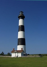
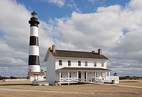
The current Bodie Island Lighthouse is the third that has stood in this vicinity of Bodie Island
on the Outer Banks
in North Carolina
and was built in 1872. It stands 156 feet (48 m) tall and is located on the Roanoke Sound
side of the first island that is part of the Cape Hatteras National Seashore
. The lighthouse
is just south of Nags Head
, a few miles before Oregon Inlet
. It is currently not climbable by the public, but restoration work is underway to make it safe for climbing.
on Pea Island in an area now under water. The first was built in 1847 and then abandoned in 1859 due to a poor foundation.
The second, built in 1859, was destroyed in 1861 by retreating Confederate
troops who feared it would be used as a Union
observation post during the Civil War
. The third and current lighthouse, with its original first order Fresnel lens
, was completed in 1872. In 1932, the light was upgraded to an electric lamp by using oil-fueled electrical generator
s. It remained manned until 1940, when the lighthouse was fully automated. In 1953, the generators were disconnected and power was supplied from the commercial electric grid.
 While some people (including North Carolinians not from the Outer Banks
) pronounce the name with a long "o" sound, it is traditionally pronounced as body. This is derived from the original name of the area, which was "Bodies Island", after the Body family from whom the land was purchased. Folklore would have you believe it is due to the number of dead sailors washed ashore from this portion of the Atlantic Ocean
, which is known as the Graveyard of the Atlantic
. Local gift shops sell maps of the shipwrecks on the ocean floor. An impressive array of ships have been sunk due to storms, shoals, and German
U-boats in World War II
.
This lighthouse appears in the background of the 1963-1964 Federal Duck Stamp
.
Bodie Island
Bodie Island is a long, narrow barrier peninsula that forms the northernmost portion of the Outer Banks of North Carolina. The land that is most commonly referred to as Bodie Island was at one time a true island, however the inlet separating it from the Currituck Banks peninsula in the north closed...
on the Outer Banks
Outer Banks
The Outer Banks is a 200-mile long string of narrow barrier islands off the coast of North Carolina, beginning in the southeastern corner of Virginia Beach on the east coast of the United States....
in North Carolina
North Carolina
North Carolina is a state located in the southeastern United States. The state borders South Carolina and Georgia to the south, Tennessee to the west and Virginia to the north. North Carolina contains 100 counties. Its capital is Raleigh, and its largest city is Charlotte...
and was built in 1872. It stands 156 feet (48 m) tall and is located on the Roanoke Sound
Roanoke Sound
The Roanoke Sound is a sound that separates Roanoke Island from Bodie Island of the Outer Banks. To the north of the Roanoke Sound lies the Albemarle Sound and to the south lies the Pamlico Sound. One bridge, which carries U.S. Highway 64, crosses the sound....
side of the first island that is part of the Cape Hatteras National Seashore
Cape Hatteras National Seashore
Cape Hatteras National Seashore preserves the portion of the Outer Banks of North Carolina from Bodie Island to Ocracoke Island, stretching over . Included within this section of barrier islands along N.C...
. The lighthouse
Lighthouse
A lighthouse is a tower, building, or other type of structure designed to emit light from a system of lamps and lenses or, in older times, from a fire, and used as an aid to navigation for maritime pilots at sea or on inland waterways....
is just south of Nags Head
Nags Head, North Carolina
Nags Head is a town in Dare County, North Carolina, United States. The population was 2,700 at the 2000 census.-History:Early maps of the area show Nags Head as a promontory of land characterized by high sand dunes visible from miles at sea...
, a few miles before Oregon Inlet
Oregon Inlet
Oregon Inlet is an inlet along North Carolina's Outer Banks. It joins the Pamlico Sound with the Atlantic Ocean and separates Bodie Island from Pea Island, which are connected by a 2.5 mile bridge that spans the inlet...
. It is currently not climbable by the public, but restoration work is underway to make it safe for climbing.
History
The preceding Bodie Island lighthouses actually stood south of Oregon InletOregon Inlet
Oregon Inlet is an inlet along North Carolina's Outer Banks. It joins the Pamlico Sound with the Atlantic Ocean and separates Bodie Island from Pea Island, which are connected by a 2.5 mile bridge that spans the inlet...
on Pea Island in an area now under water. The first was built in 1847 and then abandoned in 1859 due to a poor foundation.
The second, built in 1859, was destroyed in 1861 by retreating Confederate
Confederate States of America
The Confederate States of America was a government set up from 1861 to 1865 by 11 Southern slave states of the United States of America that had declared their secession from the U.S...
troops who feared it would be used as a Union
Union (American Civil War)
During the American Civil War, the Union was a name used to refer to the federal government of the United States, which was supported by the twenty free states and five border slave states. It was opposed by 11 southern slave states that had declared a secession to join together to form the...
observation post during the Civil War
American Civil War
The American Civil War was a civil war fought in the United States of America. In response to the election of Abraham Lincoln as President of the United States, 11 southern slave states declared their secession from the United States and formed the Confederate States of America ; the other 25...
. The third and current lighthouse, with its original first order Fresnel lens
Fresnel lens
A Fresnel lens is a type of lens originally developed by French physicist Augustin-Jean Fresnel for lighthouses.The design allows the construction of lenses of large aperture and short focal length without the mass and volume of material that would be required by a lens of conventional design...
, was completed in 1872. In 1932, the light was upgraded to an electric lamp by using oil-fueled electrical generator
Electrical generator
In electricity generation, an electric generator is a device that converts mechanical energy to electrical energy. A generator forces electric charge to flow through an external electrical circuit. It is analogous to a water pump, which causes water to flow...
s. It remained manned until 1940, when the lighthouse was fully automated. In 1953, the generators were disconnected and power was supplied from the commercial electric grid.
Outer Banks
The Outer Banks is a 200-mile long string of narrow barrier islands off the coast of North Carolina, beginning in the southeastern corner of Virginia Beach on the east coast of the United States....
) pronounce the name with a long "o" sound, it is traditionally pronounced as body. This is derived from the original name of the area, which was "Bodies Island", after the Body family from whom the land was purchased. Folklore would have you believe it is due to the number of dead sailors washed ashore from this portion of the Atlantic Ocean
Atlantic Ocean
The Atlantic Ocean is the second-largest of the world's oceanic divisions. With a total area of about , it covers approximately 20% of the Earth's surface and about 26% of its water surface area...
, which is known as the Graveyard of the Atlantic
Graveyard of the Atlantic
Graveyard of the Atlantic is a nickname of two locations known for numerous shipwrecks: the treacherous waters in the Atlantic Ocean along the Outer Banks of North Carolina and the Virginia coastline south of the entrance to the Chesapeake Bay at Cape Henry; and around Sable Island, off the coast...
. Local gift shops sell maps of the shipwrecks on the ocean floor. An impressive array of ships have been sunk due to storms, shoals, and German
Germans
The Germans are a Germanic ethnic group native to Central Europe. The English term Germans has referred to the German-speaking population of the Holy Roman Empire since the Late Middle Ages....
U-boats in World War II
World War II
World War II, or the Second World War , was a global conflict lasting from 1939 to 1945, involving most of the world's nations—including all of the great powers—eventually forming two opposing military alliances: the Allies and the Axis...
.
This lighthouse appears in the background of the 1963-1964 Federal Duck Stamp
Federal Duck Stamp
The federal duck stamp was created through a wetlands conservation program. President Herbert Hoover signed the Migratory Bird Conservation Act in 1929 to authorize the acquisition and preservation of wetlands as waterfowl habitat....
.