
N Judah
Encyclopedia
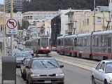
The N Judah is a Muni Metro
line in San Francisco, California
, so called as it runs along Judah Street for much of its length, named after railroad engineer Theodore Judah
. It links downtown San Francisco to the Cole Valley
and Sunset
neighborhoods. It is the busiest line in the Muni Metro system. It was one of San Francisco's streetcar lines, beginning operation in 1928, and was converted to modern light rail
operation with the creation of the Muni Metro system in the late 1970s. While many streetcar lines were converted to bus lines after World War II
, the N Judah remained a streetcar line due to its use of the Sunset Tunnel
.
depot in the Mission Bay
district to Ocean Beach
and the Great Highway
in the Sunset District. From the Caltrain
depot at Fourth and King Streets, it runs along King Street and the Embarcadero, passing by AT&T Park
. It then enters the Market Street Subway, which it shares with the five other Muni Metro lines. It exits the tunnel at Church Street and, after a brief stretch along Duboce Avenue to Duboce Park
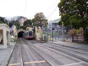
, enters the older Sunset Tunnel. This tunnel serves to avoid a hill and contains no underground stations. From the western end of the tunnel, the route goes along Carl and Irving Streets until it turns onto 9th Avenue for one block and reaches Judah Street, which the N runs on for the rest of its route. On Judah between 9th Avenue and 19th Avenue the N runs on a right-of-way
that is slightly raised above the surrounding street. There is a loop in the intersection at Judah, La Playa and Great Highway that the N uses to turn around.
 The N Judah line stops at large stations for the downtown section of the route and at smaller stops on the rest of the line. Most of the smaller stops consist of nothing more than a sign on the side of a street designating a stop, while other stops are concrete "islands" in the middle of a street next to the tracks that provide access for wheelchair
s. Muni bus routes provide service to all downtown stations and other systems with access to the stations are noted.
, where it bypasses the steep hill above the Sunset Tunnel, and serves the Lower Haight
and Haight-Ashbury
neighborhoods. It turns off Haight at Cole, and then rejoins the daytime N line at Carl.
"The N-Line car runs all day long, Judah! Judah!/It picks you up and takes you home, all the Judah day."
On December 5, 2009, SFMTA eliminated the portion of the N Judah line between Embarcadero and 4th & King/Caltrain on weekends and holidays. (That portion is still served by the T Third Street line.) N Owl service was not affected by this change. Weekend service to the Caltrain depot was restored in October 2011.
After concerns from riders of constant overcrowding of the trains on the N Judah line, Muni debuted an express bus route called the NX Judah Express on June 13, 2011.. Starting off as a pilot program, the NX (stylized as Nx) is intended to relieve overcrowding during rush hours every ten minutes. It follows the western end of the N Judah route from Ocean Beach to 19th Avenue, then operates nonstop from there to the Financial District.
Muni Metro
Muni Metro is a light rail system serving San Francisco, California, operated by the San Francisco Municipal Railway , a division of the San Francisco Municipal Transportation Agency...
line in San Francisco, California
San Francisco, California
San Francisco , officially the City and County of San Francisco, is the financial, cultural, and transportation center of the San Francisco Bay Area, a region of 7.15 million people which includes San Jose and Oakland...
, so called as it runs along Judah Street for much of its length, named after railroad engineer Theodore Judah
Theodore Judah
Theodore Dehone Judah was an American railroad engineer who dreamed of the first Transcontinental Railroad. He found investors for what became the Central Pacific Railroad...
. It links downtown San Francisco to the Cole Valley
Cole Valley, San Francisco, California
Cole Valley is a small neighborhood in San Francisco.-Location:Its boundaries are usually considered to be Hillway Street to the west, Carmel Street to the south, Clayton Street to the east, and Waller Street to the north...
and Sunset
Sunset District, San Francisco, California
The Sunset District is a large neighborhood in the west-central part of San Francisco, California, United States.-Location:The Sunset District is the largest district within the city of San Francisco. Golden Gate Park forms the neighborhood's northern border, and the Pacific Ocean forms its...
neighborhoods. It is the busiest line in the Muni Metro system. It was one of San Francisco's streetcar lines, beginning operation in 1928, and was converted to modern light rail
Light rail
Light rail or light rail transit is a form of urban rail public transportation that generally has a lower capacity and lower speed than heavy rail and metro systems, but higher capacity and higher speed than traditional street-running tram systems...
operation with the creation of the Muni Metro system in the late 1970s. While many streetcar lines were converted to bus lines after World War II
World War II
World War II, or the Second World War , was a global conflict lasting from 1939 to 1945, involving most of the world's nations—including all of the great powers—eventually forming two opposing military alliances: the Allies and the Axis...
, the N Judah remained a streetcar line due to its use of the Sunset Tunnel
Sunset Tunnel
The Sunset Tunnel is a tunnel in San Francisco, California, used by the N Judah Muni Metro line. It opened on 21 October 1928 in a ceremony presided over by Mayor James Rolph, and lies directly beneath Buena Vista Park and the steep hill that the park is located on. The western entrance to the...
.
Route Description
The line runs from the CaltrainCaltrain
Caltrain is a California commuter rail line on the San Francisco Peninsula and in the Santa Clara Valley in the United States. The northern terminus of the rail line is in San Francisco, at 4th and King streets; its southern terminus is in Gilroy...
depot in the Mission Bay
Mission Bay, San Francisco, California
Mission Bay is a neighborhood in San Francisco, California.-Location:Mission Bay is roughly bounded by Townsend Street on the north, Third Street and San Francisco Bay on the east, Mariposa Street on the south, and 7th Street and Interstate 280 on the west.-History:It was created in 1998 by the...
district to Ocean Beach
Ocean Beach, San Francisco, California
Ocean Beach is a beach that runs along the west coast of San Francisco, California, United States, at the Pacific Ocean. It is adjacent to Golden Gate Park, the Richmond District and the Sunset District. The Great Highway runs alongside the beach, and Cliff House and the site of the former Sutro...
and the Great Highway
Great Highway
The Great Highway is a road in San Francisco that forms the city's western edge along the Pacific coast. It runs for approximately next to Ocean Beach...
in the Sunset District. From the Caltrain
Caltrain
Caltrain is a California commuter rail line on the San Francisco Peninsula and in the Santa Clara Valley in the United States. The northern terminus of the rail line is in San Francisco, at 4th and King streets; its southern terminus is in Gilroy...
depot at Fourth and King Streets, it runs along King Street and the Embarcadero, passing by AT&T Park
AT&T Park
AT&T Park is a ballpark located in the South Beach neighborhood of San Francisco, California. Located at 24 Willie Mays Plaza, at the corner of Third and King Streets, it has served as the home of the San Francisco Giants of Major League Baseball since 2000....
. It then enters the Market Street Subway, which it shares with the five other Muni Metro lines. It exits the tunnel at Church Street and, after a brief stretch along Duboce Avenue to Duboce Park
Duboce Park
Duboce Park is a small urban park located between the Duboce Triangle and Lower Haight neighborhoods of San Francisco, California. The park is less than one block wide from north to south, and two blocks wide from west to east...
, enters the older Sunset Tunnel. This tunnel serves to avoid a hill and contains no underground stations. From the western end of the tunnel, the route goes along Carl and Irving Streets until it turns onto 9th Avenue for one block and reaches Judah Street, which the N runs on for the rest of its route. On Judah between 9th Avenue and 19th Avenue the N runs on a right-of-way
Right-of-way (railroad)
A right-of-way is a strip of land that is granted, through an easement or other mechanism, for transportation purposes, such as for a trail, driveway, rail line or highway. A right-of-way is reserved for the purposes of maintenance or expansion of existing services with the right-of-way...
that is slightly raised above the surrounding street. There is a loop in the intersection at Judah, La Playa and Great Highway that the N uses to turn around.
Wheelchair
A wheelchair is a chair with wheels, designed to be a replacement for walking. The device comes in variations where it is propelled by motors or by the seated occupant turning the rear wheels by hand. Often there are handles behind the seat for someone else to do the pushing...
s. Muni bus routes provide service to all downtown stations and other systems with access to the stations are noted.
Operation
As with all Muni lines, service begins around 5 a.m. on weekdays, 6 a.m. on Saturdays, and 8 a.m. on Sundays and holidays. It operates at high frequencies, mainly between 7 to 12 minutes, and mostly utilizes two-car (46m) trains during Muni Metro hours of operation. Late night service (after 12:55 a.m.) is provided by the N Owl diesel bus line. This line is generally the same as the daytime N Judah line, except it follows surface streets instead of going through the streetcar-only Market Street Subway and Sunset Tunnel. At the Ferry Portal at The Embarcadero and Folsom, it stays on The Embarcadero to Mission/Don Chee Way, then takes Steuart for one block and then turns onto Market Street, which it follows past all five underground stations served by the daytime N Judah line. It then takes Church, Hermann and Fillmore to get to Haight StreetHaight Street
Haight Street, in San Francisco, is perhaps best known as the principal street in San Francisco's Haight-Ashbury district, also known as Upper Haight. It stretches from Market Street to Stanyan Street, at Golden Gate Park. It is named after California pioneer and exchange banker Henry Haight ....
, where it bypasses the steep hill above the Sunset Tunnel, and serves the Lower Haight
Lower Haight, San Francisco, California
The Lower Haight is a neighborhood, sometimes referred to as Haight-Fillmore, in San Francisco, California.-Location:The Lower Haight lies generally along Haight Street east of Divisadero Street, and between Oak Street on the north, and Duboce Avenue on south. The eastern boundary is variously...
and Haight-Ashbury
Haight-Ashbury, San Francisco, California
Haight-Ashbury is a district of San Francisco, California, named for the intersection of Haight and Ashbury streets. It is also called The Haight and The Upper Haight.-Location:...
neighborhoods. It turns off Haight at Cole, and then rejoins the daytime N line at Carl.
"The N-Line car runs all day long, Judah! Judah!/It picks you up and takes you home, all the Judah day."
On December 5, 2009, SFMTA eliminated the portion of the N Judah line between Embarcadero and 4th & King/Caltrain on weekends and holidays. (That portion is still served by the T Third Street line.) N Owl service was not affected by this change. Weekend service to the Caltrain depot was restored in October 2011.
After concerns from riders of constant overcrowding of the trains on the N Judah line, Muni debuted an express bus route called the NX Judah Express on June 13, 2011.. Starting off as a pilot program, the NX (stylized as Nx) is intended to relieve overcrowding during rush hours every ten minutes. It follows the western end of the N Judah route from Ocean Beach to 19th Avenue, then operates nonstop from there to the Financial District.
External links
- Muni Metro and San Francisco rail map (195KB PDF)
- N Judah route information from the SF Muni Map Project
- The N-Judah Chronicles
- Muni reconsidering N-Judah Caltrain service
- T-Third line causing delays, so officials consider new routes
- September 27, 2007 Meeting on N Judah improvement at Carl and Cole stop