

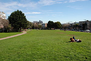
Duboce Park
Encyclopedia
Urban park
An urban park, is also known as a municipal park or a public park, public open space or municipal gardens , is a park in cities and other incorporated places to offer recreation and green space to residents of, and visitors to, the municipality...
located between the Duboce Triangle and Lower Haight
Lower Haight, San Francisco, California
The Lower Haight is a neighborhood, sometimes referred to as Haight-Fillmore, in San Francisco, California.-Location:The Lower Haight lies generally along Haight Street east of Divisadero Street, and between Oak Street on the north, and Duboce Avenue on south. The eastern boundary is variously...
neighborhoods of San Francisco, California
San Francisco, California
San Francisco , officially the City and County of San Francisco, is the financial, cultural, and transportation center of the San Francisco Bay Area, a region of 7.15 million people which includes San Jose and Oakland...
. The park is less than one block wide from north to south, and two blocks wide from west to east. Its western boundary is Scott Street and its eastern boundary is Steiner Street.
The N Judah
N Judah
The N Judah is a Muni Metro line in San Francisco, California, so called as it runs along Judah Street for much of its length, named after railroad engineer Theodore Judah. It links downtown San Francisco to the Cole Valley and Sunset neighborhoods. It is the busiest line in the Muni Metro system...
Muni Metro
Muni Metro
Muni Metro is a light rail system serving San Francisco, California, operated by the San Francisco Municipal Railway , a division of the San Francisco Municipal Transportation Agency...
streetcar line runs along Duboce Avenue, which forms the southern boundary of the park. The train tracks veer away from Duboce Avenue at the western end of the park and enter the Sunset Tunnel
Sunset Tunnel
The Sunset Tunnel is a tunnel in San Francisco, California, used by the N Judah Muni Metro line. It opened on 21 October 1928 in a ceremony presided over by Mayor James Rolph, and lies directly beneath Buena Vista Park and the steep hill that the park is located on. The western entrance to the...
. A fake BART station was constructed in the park in 2005 for filming of the movie The Pursuit of Happyness
The Pursuit of Happyness
Varèse Sarabande released the soundtrack on January 9, 2007, which included sixteen tracks.-Box office:The film debuted first at the North American box office, earning $27 million during its opening weekend and beating out heavily promoted films such as Eragon and Charlotte's Web...
; it was removed after filming.
Duboce Park is a popular site for dog walkers, and off-leash dog play is permitted in the Multi-Use Area (the southeastern section of the park) which officially opened for use on March 8, 2008. West of the Multi-Use area is a fence-enclosed area with a children's play structure. Behind the play area (to the west) is a fenced-in basketball court with multiple rims. Across from the children's play area is a half-moon shaped area designated a Public Lawn Area, and intended for use by people only (dogs are not allowed in this area.) Along Scott Street is a labyrinth
Labyrinth
In Greek mythology, the Labyrinth was an elaborate structure designed and built by the legendary artificer Daedalus for King Minos of Crete at Knossos...
, completed in 2007, designed for meditation, contemplation or relaxation.
Along the west end of the park (along Scott Street) is the Harvey Milk
Harvey Milk
Harvey Bernard Milk was an American politician who became the first openly gay man to be elected to public office in California when he won a seat on the San Francisco Board of Supervisors...
Recreational Arts Building, which underwent expansion/renovation and reopened in June 2009. The facility hosts a number of community events and includes a photography center, a studio for dance and aerobics classes, and a Midnight Music Program. In addition, the Friends of Duboce Park host an Annual Film Festival, featuring movies filmed in San Francisco, in the photography center.
San Francisco's official weather observation site is located in Duboce Park, which is near the geographical and population center of the city. Although data from the automated weather station at San Francisco International Airport
San Francisco International Airport
San Francisco International Airport is a major international airport located south of downtown San Francisco, California, United States, near the cities of Millbrae and San Bruno in unincorporated San Mateo County. It is often referred to as SFO...
, actually located about 10 miles to the south in San Mateo County
San Mateo County, California
San Mateo County is a county located in the San Francisco Bay Area of the U.S. state of California. It covers most of the San Francisco Peninsula just south of San Francisco, and north of Santa Clara County. San Francisco International Airport is located at the northern end of the county, and...
, often appears as belonging to "San Francisco" in media sources outside the Bay Area
San Francisco Bay Area
The San Francisco Bay Area, commonly known as the Bay Area, is a populated region that surrounds the San Francisco and San Pablo estuaries in Northern California. The region encompasses metropolitan areas of San Francisco, Oakland, and San Jose, along with smaller urban and rural areas...
.