
N22 road
Encyclopedia
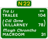
The N22 road is a national primary road
National primary road
A national primary road is a road classification in the Republic of Ireland. National primary roads form the major routes between the major urban centres. There are over 2,700km of national primary roads. This category of road has the prefix "N" followed by one or two digits...
in Ireland
Republic of Ireland
Ireland , described as the Republic of Ireland , is a sovereign state in Europe occupying approximately five-sixths of the island of the same name. Its capital is Dublin. Ireland, which had a population of 4.58 million in 2011, is a constitutional republic governed as a parliamentary democracy,...
which goes through counties Kerry
County Kerry
Kerry means the "people of Ciar" which was the name of the pre-Gaelic tribe who lived in part of the present county. The legendary founder of the tribe was Ciar, son of Fergus mac Róich. In Old Irish "Ciar" meant black or dark brown, and the word continues in use in modern Irish as an adjective...
and Cork
County Cork
County Cork is a county in Ireland. It is located in the South-West Region and is also part of the province of Munster. It is named after the city of Cork . Cork County Council is the local authority for the county...
, from Tralee in the west through Killarney
Killarney
Killarney is a town in County Kerry, southwestern Ireland. The town is located north of the MacGillicuddy Reeks, on the northeastern shore of the Lough Lein/Leane which are part of Killarney National Park. The town and its surrounding region are home to St...
, Macroom
Macroom
Macroom is a market town in Ireland located in a valley on the River Sullane, a tributary of the River Lee, between Cork and Killarney. It is one of the key gateways to the tourist region of West Cork. The town recorded a population on 3,553 in the 2006 national census...
and Ballincollig
Ballincollig
Ballincollig is a satellite town in County Cork, Ireland, approximately 9 km west of Cork city. It is located beside the River Lee on the R608 regional road. In 2006 the population of Ballincollig DED was 16,308. The nearest towns include: Ballinora, Ovens, Killumney, Inniscarra, Blarney ,...
to Cork City
Cork (city)
Cork is the second largest city in the Republic of Ireland and the island of Ireland's third most populous city. It is the principal city and administrative centre of County Cork and the largest city in the province of Munster. Cork has a population of 119,418, while the addition of the suburban...
in the east.
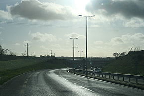
Sections of the N22 have been substantially upgraded in recent years. During the 1980s and 1990s a 25 km (15.5 mi) section between Killarney and the border with County Cork was rebuilt and widened. An auxiliary climbing lane is provided on the steep grade sections. The late 1980s saw a 3 km (1.9 mi) bypass of Killarney. In 2004 the Ballincollig bypass west of Cork city has been completed. This is a 11 km (6.8 mi) dual carriageway road built to Motorway standards that connects with the N25 Cork South Ring Road
N25 road
The N25 road is a national primary road in Ireland, forming the route from Cork to Rosslare Europort via Waterford City. The road is part of the E30 European route and a short section is also part of the E01 European route...
. In 2005 4 km (2.5 mi) of the road between Tralee and Farranfore
Farranfore
Farranfore is a village in County Kerry, Ireland. It lies on the N22 road approximately midway between Tralee and Killarney and on the railway line connecting those two towns....
has been upgraded. This adds to a 4 km section opened in 2002.
Planned upgrades
Five major projects in planning for the N22:- BallyvourneyBallyvourneyBaile Bhuirne , anglicised as Ballyvourney is a Gaeltacht village in south-west County Cork, Ireland. It is a civil parish in the barony of Muskerry West and is also one half of the Ecclesiastical parish of Baile Bhuirne agus Cúil Aodha in the Roman Catholic Diocese of Cloyne-Location and...
– MacroomMacroomMacroom is a market town in Ireland located in a valley on the River Sullane, a tributary of the River Lee, between Cork and Killarney. It is one of the key gateways to the tourist region of West Cork. The town recorded a population on 3,553 in the 2006 national census... - KillarneyKillarneyKillarney is a town in County Kerry, southwestern Ireland. The town is located north of the MacGillicuddy Reeks, on the northeastern shore of the Lough Lein/Leane which are part of Killarney National Park. The town and its surrounding region are home to St...
– FarranforeFarranforeFarranfore is a village in County Kerry, Ireland. It lies on the N22 road approximately midway between Tralee and Killarney and on the railway line connecting those two towns.... - Tralee eastern bypass with a spur to Ballingrelagh
- MacroomMacroomMacroom is a market town in Ireland located in a valley on the River Sullane, a tributary of the River Lee, between Cork and Killarney. It is one of the key gateways to the tourist region of West Cork. The town recorded a population on 3,553 in the 2006 national census...
to BallincolligBallincolligBallincollig is a satellite town in County Cork, Ireland, approximately 9 km west of Cork city. It is located beside the River Lee on the R608 regional road. In 2006 the population of Ballincollig DED was 16,308. The nearest towns include: Ballinora, Ovens, Killumney, Inniscarra, Blarney ,...
rebuild - Cork Northern Ring Road, connecting with M8M8 motorway (Ireland)The M8 motorway is an inter-urban motorway in Ireland, which forms part of the road from the capital - Dublin - to Cork city. The 149 km motorway commences in the townland of Aghaboe, County Laois and runs through the counties of Kilkenny, North Tipperary, South Tipperary and Limerick,...
junction 18.
Additionally there are proposals for 2 plus 1 upgrades to the Killarney – Ballyvourney section. The Farranfore – Killarney and Ballyvourney – Macroom schemes are to be developed as 2 plus 1 roads also. The Cork Northern Ring Road is currently in planning, and consists of 17 km (10.6 mi) of dual carriageway. Part of the Cork Northern Ring Road scheme would be designated motorway.
It is famous for The Sculpture Road to Killarney where the internationally respected sculptor, Tighe O'Donoghue/Ross of Glenflesk and his son, Eoghan, were commissioned to place sculpted stones along the new part of the road between Killarney and the county bounds to Cork. Most of the stones were excavated during the building of the road, varying between one to three tons in weight. The most popular sculpture is that of a rearing horse, set atop a rise along the road near Clonkeen. Made from ferro-cement over a steel infrastructure, Capall Mor accoutered with a helmet featuring a unicorn horn, typical of the war horses used by the Celtic chiefs during their battles. There are broken chains around its front legs, signifying freedom.
See also
- Roads in IrelandRoads in IrelandThe island of Ireland, comprising Northern Ireland and the Republic of Ireland, has an extensive network of tens of thousands of kilometres of public roads, usually surfaced. These roads have been developed and modernised over centuries, from trackways suitable only for walkers and horses, to...
- Motorways in Ireland
- National secondary roadNational secondary roadA national secondary road is a category of road in Ireland. These roads form an important part of the national route network, but are secondary to the main arterial routes which are classified as national primary roads. National secondary roads are designated with route numbers higher than those...
- Regional roadRegional roadA regional road in Ireland is a class of road not forming a major route , but nevertheless forming a link in the national route network. There are over 11,600 kilometres of regional roads. Regional roads are numbered with three digit route numbers, prefixed by "R" A regional road in Ireland is a...