
Municipalities of the Faroe Islands
Encyclopedia
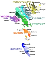
The Faroe Islands
are administratively divided in 30 municipalities (kommunur), with about 120 cities and villages. Until December 31, 2008, there were 34 municipalities, and until December 31, 2004, there were 48 municipalities. In the coming years the number of Faroese municipalities is expected to drop to somewhere between 7 and 15, as there is currently a rationale towards municipal amalgamation
and a decentralization of public services. In 1998 it was foreseen that no municipality should have fewer than 2,000 inhabitants, but whether this will be true is a political question. The Faroese government has furthermore decided not to conduct forced, top-down amalgamation, but to leave the process to the free will of the municipalities. In many small municipalities there is some anguish towards the amalgamation process, and in turn two kinds of municipalities are being created: large municipalities (town-municipalities) that are eager to attract smaller municipalities into amalgamation, and small municipalities that are either trying to avoid amalgamation or seek to amalgamate with other small municipalities. The geographically large Sunda kommuna is an example of this. The larger municipalities are organized in Kommunusamskipan Føroya
(KFS) and the smaller are organized in Føroya Kommunufelag
(FKF).
Faroe Islands
The Faroe Islands are an island group situated between the Norwegian Sea and the North Atlantic Ocean, approximately halfway between Scotland and Iceland. The Faroe Islands are a self-governing territory within the Kingdom of Denmark, along with Denmark proper and Greenland...
are administratively divided in 30 municipalities (kommunur), with about 120 cities and villages. Until December 31, 2008, there were 34 municipalities, and until December 31, 2004, there were 48 municipalities. In the coming years the number of Faroese municipalities is expected to drop to somewhere between 7 and 15, as there is currently a rationale towards municipal amalgamation
Amalgamation (politics)
A merger or amalgamation in a political or administrative sense is the combination of two or more political or administrative entities such as municipalities , counties, districts, etc. into a single entity. This term is used when the process occurs within a sovereign entity...
and a decentralization of public services. In 1998 it was foreseen that no municipality should have fewer than 2,000 inhabitants, but whether this will be true is a political question. The Faroese government has furthermore decided not to conduct forced, top-down amalgamation, but to leave the process to the free will of the municipalities. In many small municipalities there is some anguish towards the amalgamation process, and in turn two kinds of municipalities are being created: large municipalities (town-municipalities) that are eager to attract smaller municipalities into amalgamation, and small municipalities that are either trying to avoid amalgamation or seek to amalgamate with other small municipalities. The geographically large Sunda kommuna is an example of this. The larger municipalities are organized in Kommunusamskipan Føroya
Kommunusamskipan Føroya
Kommunusamskipan Føroya is the organization of the greater municipalities of the Faroe Islands. The members are Tórshavn, Klaksvík, Runavík, Tvøroyri, Fuglafjørður, Vágur and Sandur....
(KFS) and the smaller are organized in Føroya Kommunufelag
Føroya Kommunufelag
Føroya Kommunufelag is the original municipal organization of the Faroe Islands. All Faroese municipalities except those in Kommunusamskipan Føroya are members of Føroya Kommunufelag. Føroya Kommunfelag also hosts the municipal environmental bureau, Agendaskrivstovan....
(FKF).
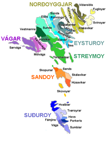
30 municipalities (since 2009)
As of January 1, 2009, there are 30 municipalities:| Municipality | Inhabitants per km² Population density Population density is a measurement of population per unit area or unit volume. It is frequently applied to living organisms, and particularly to humans... | Area (in km²) | Markatal | Island(s) | Region | |
|---|---|---|---|---|---|---|
| Tórshavn Tórshavnar kommuna Tórshavnar kommuna is the municipality of the Faroese capital Tórshavn and its surroundings. The municipality covers the southern half of Streymoy island and adjacent minor islands.-Population progression:... |
19,339 | 112 | 173 | 327 | Streymoy Streymoy Streymoy is the largest and most populated island of the Faroe Islands. The capital, Tórshavn is located there. The name means "island of currents".- Geography :... |
Tórshavn |
| Klaksvík Klaksvík Klaksvík is the second largest town of the Faroe Islands.The town is located on Borðoy, which is one of the northernmost islands .... |
4,938 | 44 | 113 | Borðoy Borðoy Borðoy is an island in the north-east of the Faroe Islands. There are eight settlements: Klaksvík , Norðoyri, Ánir, Árnafjørður, Strond, Norðtoftir, Depil and Norðdepil. There are also three abandoned settlements: Skálatoftir, Múli and Fossá, all in the north... , Svínoy Svínoy Svínoy is an island located in the north-east of the Faroe Islands, to the east of Borðoy and Viðoy. It is divided into two unequally sized peninsulas. The island takes its name from Old Norse, Svíney, meaning "Swine Isle"... |
Klaksvík | |
| Runavík Runavík Runavík is a comparatively urbanised village in the Faroe Islands. It lies on the south half of the isle of Eysturoy. The municipality of the same name incorporates 14 settlements including Æðuvík, Rituvík, Saltangará, Glyvrar, Lambi, Lambareiði, Søldarfjørður, Skipanes, Skáli, Skálafjørður,... |
3,753 | 39 | 96 | Eysturoy Eysturoy Eysturoy means East island and is the second-largest of the Faroe Islands in the North Atlantic, both in size and population. It is separated by a narrow sound from the main island of Streymoy. Eysturoy is extremely rugged, with some 66 separate mountain peaks, including Slættaratindur, the... |
Southern Eysturoy | |
| Eystur Eysturkommuna Eystur is a municipality in the Faroese Islands. It covers a part of the island of Eysturoy.The municipality was created on 1 January 2009 from the merger of Leirvík and Gøtu municipalities. It includes the villages of Norðragøta, Gøtueiði, Gøtugjógv and Syðrugøta, as well as other small settlements... |
1,939 | 46 | 42 | Eysturoy Eysturoy Eysturoy means East island and is the second-largest of the Faroe Islands in the North Atlantic, both in size and population. It is separated by a narrow sound from the main island of Streymoy. Eysturoy is extremely rugged, with some 66 separate mountain peaks, including Slættaratindur, the... |
Southern Eysturoy | |
| Vágar Vága kommuna Vága kommuna is a municipality in the Faroese Islands. It covers the eastern part of the island of Vágar .... |
1,897 | 18 | 108 | Vágar Vágar Vágar is one of the 18 islands in the archipelago of the Faroe Islands and the most westerly of the large islands. With a size of 178 km² , it ranks number three, behind Streymoy and Eysturoy.... |
Vágar | |
| Tvøroyri Tvøroyri Tvøroyri lies picturesquely on the north side of the Trongisvágsfjørður on the east coast of Suðuroy, Faroe Islands.... |
1,819 | 42 | 43 | 60 | Suðuroy Suðuroy Suðuroy is the southernmost of the Faroe Islands. The island covers 163.7 km². In 2010 there were 4763 inhabitants, but there has been a gradual decline in the population numbers ever since the 1950s.... |
Suðuroy |
| Fuglafjørður Fuglafjørður Fuglafjørður is a village on Eysturoy's east coast in the Faroe Islands. Its name means "fjord of birds".* Population: 1562* Location: * Postal code : FO 530* Municipality: Fuglafjardar* Football team: ÍF Fuglafjørður... |
1,584 | 70 | 23 | 32 | Eysturoy Eysturoy Eysturoy means East island and is the second-largest of the Faroe Islands in the North Atlantic, both in size and population. It is separated by a narrow sound from the main island of Streymoy. Eysturoy is extremely rugged, with some 66 separate mountain peaks, including Slættaratindur, the... |
Northern Eysturoy |
| Sunda Sunda Kommuna Sunda kommuna is an amalgamated-municipality stretching across vast areas of the two large Faroese islands Streymoy and Eysturoy. Sunda kommuna is formed by the former municipalities of Hósvíkar kommuna, Hvalvíkar kommuna, Saksunar kommuna, Haldarsvíkar kommuna, Sunda kommuna and Gjáar kommuna... |
1,564 | 10 | 158 | 152 | Eysturoy Eysturoy Eysturoy means East island and is the second-largest of the Faroe Islands in the North Atlantic, both in size and population. It is separated by a narrow sound from the main island of Streymoy. Eysturoy is extremely rugged, with some 66 separate mountain peaks, including Slættaratindur, the... |
Northern Eysturoy |
| Vágur Vágur Vágur meaning Bay is a town on the Faroe Islands of Suðuroy, it is situated on the east coast of the island on the Vágsfjørður fjord, and dates from the fourteenth century. Expansion has meant that the nearby town of Nes is now a suburb of Vágur... |
1,402 | 67 | 21 | 61 | Suðuroy Suðuroy Suðuroy is the southernmost of the Faroe Islands. The island covers 163.7 km². In 2010 there were 4763 inhabitants, but there has been a gradual decline in the population numbers ever since the 1950s.... |
Suðuroy |
| Nes | 1,238 | 88 | 14 | 40 | Eysturoy Eysturoy Eysturoy means East island and is the second-largest of the Faroe Islands in the North Atlantic, both in size and population. It is separated by a narrow sound from the main island of Streymoy. Eysturoy is extremely rugged, with some 66 separate mountain peaks, including Slættaratindur, the... |
Southern Eysturoy |
| Vestmanna Vestmanna Vestmanna is a town in the Faroe Islands on the west of the island of Streymoy. It was formerly a ferry port, until an undersea tunnel was built from Vágar to Kvívík and Stykkið. The cliffs west of Vestmanna, Vestmannabjørgini are very popular for excursions by boat.A 'Vestmann' was a "Westman",... |
1,234 | 24 | 52 | 56 | Streymoy Streymoy Streymoy is the largest and most populated island of the Faroe Islands. The capital, Tórshavn is located there. The name means "island of currents".- Geography :... |
Streymoy |
| Sørvágur Sørvágs Kommuna Sørvágs kommuna is the westernmost municipality in the Faroe Islands. It consists of the villages of Sørvágur, Bøur, Gásadalur and Mykines. Originally the municipality only included the village of Sørvágur, but on January 2005 the municipality of Sørvágur agreed to merge with the smaller... |
1,071 | 13 | 84 | 124 | Vágar Vágar Vágar is one of the 18 islands in the archipelago of the Faroe Islands and the most westerly of the large islands. With a size of 178 km² , it ranks number three, behind Streymoy and Eysturoy.... |
Vágar |
| Sjóvar Sjóvar kommuna Sjóvar kommuna is a municipality of the Faroese Islands. It covers a part of the island of Eysturoy. It consists of the villages of Strendur, Innan Glyvur, Selatrað, Morskranes en Kolbanargjógv.... |
1,027 | 31 | 33 | 70 | Eysturoy Eysturoy Eysturoy means East island and is the second-largest of the Faroe Islands in the North Atlantic, both in size and population. It is separated by a narrow sound from the main island of Streymoy. Eysturoy is extremely rugged, with some 66 separate mountain peaks, including Slættaratindur, the... |
Southern Eysturoy |
| Hvalba Hvalba Hvalba is a village and a municipality, which consists of Hvalba, Nes-Hvalba and Sandvík. The total population of Hvalba Municipality was 723 as of 1 January 2010; the population of Hvalba and Nes was 626 and the population of Sandvík was 97. Hvalba is one of the larger villages in the Faroe... |
765 | 19 | 40 | 99 | Suðuroy Suðuroy Suðuroy is the southernmost of the Faroe Islands. The island covers 163.7 km². In 2010 there were 4763 inhabitants, but there has been a gradual decline in the population numbers ever since the 1950s.... |
Suðuroy |
| Eiði Eiði Eiði is a large village located on the north-west tip of Eysturoy, Faroe Islands Its name means isthmus in the Faroese language. The town has a population of 669In the center of the village there is a large stone church from 1881... |
705 | 19 | 37 | 49 | Eysturoy Eysturoy Eysturoy means East island and is the second-largest of the Faroe Islands in the North Atlantic, both in size and population. It is separated by a narrow sound from the main island of Streymoy. Eysturoy is extremely rugged, with some 66 separate mountain peaks, including Slættaratindur, the... |
Northern Eysturoy |
| Kvívík Kvívík Kvívík is a village on the west coast of Streymoy in the Faroe Islands, in the eponymous municipality of Kvívík.The village is on both sides of a narrow bay and the small river Stora.... |
615 | 13 | 49 | 75 | Streymoy Streymoy Streymoy is the largest and most populated island of the Faroe Islands. The capital, Tórshavn is located there. The name means "island of currents".- Geography :... |
Streymoy |
| Sandur Sandur (Faroe Islands) Sandur is a village on the south coast of the island of Sandoy in the Faroe Islands. The Sandur hoard, dating to the end of the 11th century, suggests the long history of the village. In January 2010 the population stood at 558.... |
586 | 12 | 48 | 97 | Sandoy Sandoy Sandoy is a small island that is part of the Faroe Islands, an autonomous region of the Kingdom of Denmark. The largest population center on the island is the village of Sandur with a population of six hundred.... |
Sandoy |
| Skopun Skopun Skopun is a town in the Faroe Islands situated on the northern coast of Sandoy, Sand Island. Skopun is the second largest town on the island.*Population: 499 *Postcode: FO 240... |
507 | 56 | 9 | 0 | Sandoy Sandoy Sandoy is a small island that is part of the Faroe Islands, an autonomous region of the Kingdom of Denmark. The largest population center on the island is the village of Sandur with a population of six hundred.... |
Sandoy |
| Hvannasund Hvannasund Hvannasund is a village and municipality in the Faroe Islands, an autonomous region in Denmark.... |
441 | 13 | 33 | 38 | Viðoy Viðoy Viðoy is the northern-most island in the Faroe Islands, located east of Borðoy to which it is linked via a causeway. The name means wood island, despite the fact that no trees grow on the island: the name relates to the driftwood that floats in from Siberia and North America.- Geography :The... and Borðoy Borðoy Borðoy is an island in the north-east of the Faroe Islands. There are eight settlements: Klaksvík , Norðoyri, Ánir, Árnafjørður, Strond, Norðtoftir, Depil and Norðdepil. There are also three abandoned settlements: Skálatoftir, Múli and Fossá, all in the north... |
Klaksvík |
| Sumba Sumba, Faroe Islands Sumba is the southernmost place of the Faroe Islands on the island of Suðuroy. It is located in the Sumbiar municipality.The municipality has 385 inhabitants. 258 of these people are living in Sumba. The other villages in the Municipality of Sumba are: Lopra , Akrar , Víkarbyrgi .Sumba is known for... |
383 | 15 | 25 | 64 | Suðuroy Suðuroy Suðuroy is the southernmost of the Faroe Islands. The island covers 163.7 km². In 2010 there were 4763 inhabitants, but there has been a gradual decline in the population numbers ever since the 1950s.... |
Suðuroy |
| Viðareiði Viðareiði Viðareiði is the northernmost settlement in the Faroe Islands and lies on the Island of Viðoy, which belongs to the Norðoyar Region. It lies on an isthmus with high mountains to both the north and south.... |
339 | 11 | 30 | 48 | Viðoy Viðoy Viðoy is the northern-most island in the Faroe Islands, located east of Borðoy to which it is linked via a causeway. The name means wood island, despite the fact that no trees grow on the island: the name relates to the driftwood that floats in from Siberia and North America.- Geography :The... |
Norðoyggjar |
| Porkeri Porkeri Porkeri is a village in the Faroe Islands, situated north of Vágur on Suðuroy's east coast. As of 2004 it had a population of 332. and has been inhabited at least as early as the 14th century.... |
333 | 24 | 14 | 37 | Suðuroy Suðuroy Suðuroy is the southernmost of the Faroe Islands. The island covers 163.7 km². In 2010 there were 4763 inhabitants, but there has been a gradual decline in the population numbers ever since the 1950s.... |
Suðuroy |
| Skálavík Skálavík Skálavík is a village and municipality on the eastern coast of the Faroese island Sandoy . The 2005 population was 182. Its postal code is FO 220. The village's stone church was built in 1891. The famous Faroese writers Heðin Brú and Kristian Osvald Viderø were both born in Skálavík.In late... |
183 | 6 | 29 | 24 | Sandoy Sandoy Sandoy is a small island that is part of the Faroe Islands, an autonomous region of the Kingdom of Denmark. The largest population center on the island is the village of Sandur with a population of six hundred.... |
Sandoy |
| Kunoy Kunoy Kunoy is an island located in the north-east of the Faroe Islands between Kalsoy and Borðoy .- Settlements and transport :... |
157 | 4 | 35 | 65 | Kunoy Kunoy Kunoy is an island located in the north-east of the Faroe Islands between Kalsoy and Borðoy .- Settlements and transport :... |
Norðoyggjar |
| Húsavík Húsavík Húsavík is a town in Norðurþing municipality on the north coast of Iceland on the shores of Skjálfandi bay with 2,237 inhabitants.-Overview:The income of the inhabitants is derived from tourism and fishing, as well as retail and small industry... |
131 | 5 | 26 | 66 | Sandoy Sandoy Sandoy is a small island that is part of the Faroe Islands, an autonomous region of the Kingdom of Denmark. The largest population center on the island is the village of Sandur with a population of six hundred.... |
Sandoy |
| Hov Hov, Faroe Islands *Population: 133*Postal code : FO 960*Location: *Municipality: HovsHov is a village located on Suduroy’s east coast, in the Faroe Islands; it is frequently mentioned in the country's history. Salmon sea farming has been practiced in Hov since the 1980’s... |
125 | 12 | 10 | 24 | Suðuroy Suðuroy Suðuroy is the southernmost of the Faroe Islands. The island covers 163.7 km². In 2010 there were 4763 inhabitants, but there has been a gradual decline in the population numbers ever since the 1950s.... |
Suðuroy |
| Fámjin Fámjin Fámjin is a village, located in the middle of the coastline on the western side of Suðuroy, the southernmost island in Faroe Islands. It has a population of around 100.... |
113 | 9 | 13 | 24 | Suðuroy Suðuroy Suðuroy is the southernmost of the Faroe Islands. The island covers 163.7 km². In 2010 there were 4763 inhabitants, but there has been a gradual decline in the population numbers ever since the 1950s.... |
Suðuroy |
| Húsar Húsar Húsar is a village on the East side of Kalsoy, Faroe Islands. It is the oldest of the villages on Kalsoy. The church, which is made of stone, was built in 1920. Húsar is connected to Klaksvík by a ferry that visits the village three times a day... |
61 | 4 | 16 | 41 | Kalsoy Kalsoy Kalsoy is an island located in the north-east of the Faroe Islands between Eysturoy and Kunoy.- Geography :The western coast has dramatically steep cliffs for the full length of the island, whereas idyllic valleys on the eastern slopes protect the four tiny settlements, Húsar, Mikladalur,... |
Norðoyggjar |
| Skúvoy Skúvoy Skúvoy is an island in central Faroe Islands, located to the south of Sandoy. It is named after the large number of skua present on the island . There is only one settlement on the island: Skúvoy on the east coast... |
57 | 4 | 13 | 73 | Skúvoy Skúvoy Skúvoy is an island in central Faroe Islands, located to the south of Sandoy. It is named after the large number of skua present on the island . There is only one settlement on the island: Skúvoy on the east coast... |
Sandoy Sandoy Sandoy is a small island that is part of the Faroe Islands, an autonomous region of the Kingdom of Denmark. The largest population center on the island is the village of Sandur with a population of six hundred.... |
| Fugloy Fugloy Fugloy is the eastern-most island in the Faroe Islands. The name means bird island, and refers to the large number of birds that nest on the island's cliffs.- Geography :... |
44 | 4 | 11 | 14 | Fugloy Fugloy Fugloy is the eastern-most island in the Faroe Islands. The name means bird island, and refers to the large number of birds that nest on the island's cliffs.- Geography :... |
Norðoyggjar |
History
- On 1 January 2009 (34 municipalities reduced to 30):
- Funningur fused with Runavík.
- Gøtu and Leirvík fused into Eystur.
- Miðvágur and SandavágurSandavágurThe town of Sandavágur lies on the south coast of the Faroese island of Vágar, and has been voted the most well-kept village in the Faroes twice. The name Sandavágur means sandy creek and refers to the beach down by the inlet. From one point in Sandavágur you can get a view of all the southern...
fused into Vágar. - Svínoy fused with Klaksvík.
- On 1 January 2005 (38 municipalities reduced to 34):
- Elduvík, Oyndarfjørð and Skála fused with Runavík.
- Gjáar, Haldarsvík, Hósvík, Hvalvík and SaksunSaksunSaksun is a village near the north-west coast of the Faroese island of Streymoy.*Population: 34*Postal code : FO 436*Location: *Municipality: Saksunar...
fused with Sunda. - Hestur, Kirkjubøur and Nólsoy fused with Tórshavn.
- Mikladalur fused with Klaksvík.
- Mykines fused with Sørvág.
- On 1 January 1997
- Argja and Kaldbaks fused with Tórshavn.
- On 1 August 1948
- Funningur split into Funningur and Gjáar.
Source
- Hagstova Føroya - Municipalities by size and width, population growth and density, age and sex - December 31, 2002 (in PDFPortable Document FormatPortable Document Format is an open standard for document exchange. This file format, created by Adobe Systems in 1993, is used for representing documents in a manner independent of application software, hardware, and operating systems....
)
See also
- List of towns in the Faroe Islands
- Regions of the Faroe IslandsRegions of the Faroe IslandsThe Faroe Islands are divided into six regions, seven constituencies and 30 municipalities. The region of Streymoy is composed of two constituencies. Each region has one sheriff....
- List of islands of the Faroe Islands
- Subdivisions of Norden
- Politics of the Faroe IslandsPolitics of the Faroe IslandsPolitics of the Faroe Islands takes place in a framework of a parliamentary representative democratic dependency, whereby the Prime Minister of the Faroe Islands is the head of government, and of a multi-party system. The Faroe Islands are politically associated with the Kingdom of Denmark, but...