
Mount Tate
Encyclopedia
is located in the southeastern area of Toyama Prefecture
, Japan
. It is one of the tallest peaks in the Hida Mountains
at 3015 m (9,892 ft) and, along with Mount Fuji
and Mount Haku
, it is one of Japan's . The climbing season for Mount Tate is from April until November. It was first climbed by Saeki no Ariyori during Japan's Asuka period
. The area was designated the Chūbu-Sangaku National Park
on December 4, 1934.
for the mountain (立山 Tateyama) mean "stand or standing" and "mountain," respectively. Another common English name is Mount Tateyama. (The pronunciation of tate is two syllables similar to pâté
rather than gate). The Toyama Prefectural Government uses the name Mount Tateyama as an official translation of the Japanese mountain because it shares its name with the neighboring town of Tateyama
. Some English-speaking locals just use the Japanese name Tateyama when referring to the mountain, both variations are used interchangeably.
and gneiss
. However, located along the ridge and plateau about 2 km (1.2 mi) west of the summit is a small andesite
-dacite
stratovolcano
, confusingly also named Tateyama after its far more famous neighbor. This volcano has an elevation of 2621 m (8,599 ft), and has had minor historical eruptions, the latest in 1839.
, which is accessible by train from the prefecture's capital city, Toyama
. Public transportation will take climbers and tourists as far as the Murodo Plateau Station at an altitude of 2450 m (8,038 ft), from where individuals may climb to the peak on foot.
Located on the Murodo Plateau is a shopping area and onsen
bath. The onsen on Tateyama is famously known for its use of sulfur spring water for the bath, leaving a noticeable aroma that can be detected even while ascending the mountain.
On clear days, climbers can see Shōmyō Falls
(the tallest waterfall in Japan) across the valley while traveling along the main road from Tateyama Station to the Murodo Plateau.
s, each of which flows to the Sea of Japan
.
Toyama Prefecture
is a prefecture of Japan located in the Hokuriku region on Honshū island. The capital is the city of Toyama.Toyama is the leading industrial prefecture on the Japan Sea coast, and has the industrial advantage of cheap electricity due to abundant water resources....
, Japan
Japan
Japan is an island nation in East Asia. Located in the Pacific Ocean, it lies to the east of the Sea of Japan, China, North Korea, South Korea and Russia, stretching from the Sea of Okhotsk in the north to the East China Sea and Taiwan in the south...
. It is one of the tallest peaks in the Hida Mountains
Hida Mountains
The , or , is a Japanese mountain range which stretches through Nagano, Toyama and Gifu prefectures. A small portion of the mountains also reach into Niigata Prefecture. William Gowland coined the phrase "Japanese Alps" during his time in Japan, but he was only referring to the Hida Mountains when...
at 3015 m (9,892 ft) and, along with Mount Fuji
Mount Fuji
is the highest mountain in Japan at . An active stratovolcano that last erupted in 1707–08, Mount Fuji lies about south-west of Tokyo, and can be seen from there on a clear day. Mount Fuji's exceptionally symmetrical cone is a well-known symbol of Japan and it is frequently depicted in art and...
and Mount Haku
Mount Haku
, or Mount Hakusan, is a potentially active volcano. The stratovolcano is located on the borders of Gifu, Fukui and Ishikawa prefectures in Japan. It is thought to have first been active 300,000 to 400,000 years ago, with the most recent eruption occurring in 1659...
, it is one of Japan's . The climbing season for Mount Tate is from April until November. It was first climbed by Saeki no Ariyori during Japan's Asuka period
Asuka period
The , was a period in the history of Japan lasting from 538 to 710 , although its beginning could be said to overlap with the preceding Kofun period...
. The area was designated the Chūbu-Sangaku National Park
Chubu-Sangaku National Park
is a national park in the Chūbu region, Honshū, Japan. It was established around the Hida Mountains and encompasses parts of Nagano, Gifu, Toyama and Niigata prefectures...
on December 4, 1934.
Name
The kanjiKanji
Kanji are the adopted logographic Chinese characters hanzi that are used in the modern Japanese writing system along with hiragana , katakana , Indo Arabic numerals, and the occasional use of the Latin alphabet...
for the mountain (立山 Tateyama) mean "stand or standing" and "mountain," respectively. Another common English name is Mount Tateyama. (The pronunciation of tate is two syllables similar to pâté
Pâté
Pâté is a mixture of ground meat and fat minced into a spreadable paste. Common additions include vegetables, herbs, spices, and either wine or cognac, armagnac or brandy...
rather than gate). The Toyama Prefectural Government uses the name Mount Tateyama as an official translation of the Japanese mountain because it shares its name with the neighboring town of Tateyama
Tateyama, Toyama
is a town located in Nakaniikawa District, Toyama, Japan.As of 2003, the town has an estimated population of 28,123 and a density of 91.51 persons per km². The total area is 307.31 km².-External links:*...
. Some English-speaking locals just use the Japanese name Tateyama when referring to the mountain, both variations are used interchangeably.
Geology
The mountain is composed primarily of graniteGranite
Granite is a common and widely occurring type of intrusive, felsic, igneous rock. Granite usually has a medium- to coarse-grained texture. Occasionally some individual crystals are larger than the groundmass, in which case the texture is known as porphyritic. A granitic rock with a porphyritic...
and gneiss
Gneiss
Gneiss is a common and widely distributed type of rock formed by high-grade regional metamorphic processes from pre-existing formations that were originally either igneous or sedimentary rocks.-Etymology:...
. However, located along the ridge and plateau about 2 km (1.2 mi) west of the summit is a small andesite
Andesite
Andesite is an extrusive igneous, volcanic rock, of intermediate composition, with aphanitic to porphyritic texture. In a general sense, it is the intermediate type between basalt and dacite. The mineral assemblage is typically dominated by plagioclase plus pyroxene and/or hornblende. Magnetite,...
-dacite
Dacite
Dacite is an igneous, volcanic rock. It has an aphanitic to porphyritic texture and is intermediate in composition between andesite and rhyolite. The relative proportions of feldspars and quartz in dacite, and in many other volcanic rocks, are illustrated in the QAPF diagram...
stratovolcano
Stratovolcano
A stratovolcano, also known as a composite volcano, is a tall, conical volcano built up by many layers of hardened lava, tephra, pumice, and volcanic ash. Unlike shield volcanoes, stratovolcanoes are characterized by a steep profile and periodic, explosive eruptions...
, confusingly also named Tateyama after its far more famous neighbor. This volcano has an elevation of 2621 m (8,599 ft), and has had minor historical eruptions, the latest in 1839.
Location
Tateyama is located in southeastern Toyama Prefecture. At the base of the mountain is the town of TateyamaTateyama, Toyama
is a town located in Nakaniikawa District, Toyama, Japan.As of 2003, the town has an estimated population of 28,123 and a density of 91.51 persons per km². The total area is 307.31 km².-External links:*...
, which is accessible by train from the prefecture's capital city, Toyama
Toyama, Toyama
is the capital city of Toyama Prefecture, Japan, located on the coast of the Sea of Japan in the Chūbu region on central Honshū, about 200 km north of the city of Nagoya and 300 km northwest of Tokyo....
. Public transportation will take climbers and tourists as far as the Murodo Plateau Station at an altitude of 2450 m (8,038 ft), from where individuals may climb to the peak on foot.
Mountain sights
Located on the peak of the mountain is Oyama Shrine, where climbers can receive a blessing and warm sake from a priest. There is also a rest area where climbers may buy food, drinks and souvenirs.Located on the Murodo Plateau is a shopping area and onsen
Onsen
An is a term for hot springs in the Japanese language, though the term is often used to describe the bathing facilities and inns around the hot springs. As a volcanically active country, Japan has thousands of onsen scattered along its length and breadth...
bath. The onsen on Tateyama is famously known for its use of sulfur spring water for the bath, leaving a noticeable aroma that can be detected even while ascending the mountain.
On clear days, climbers can see Shōmyō Falls
Shomyo Falls
are located in the town of Tateyama, Toyama Prefecture, Japan. Shōmyō-daki is the highest waterfall in Japan at 350 m . The falls have four stages: the first 70 m, the second 58 m, the third 96 m and the last 126 m high...
(the tallest waterfall in Japan) across the valley while traveling along the main road from Tateyama Station to the Murodo Plateau.
Nearby mountains
| Image | Mountain Mountain Image:Himalaya_annotated.jpg|thumb|right|The Himalayan mountain range with Mount Everestrect 58 14 160 49 Chomo Lonzorect 200 28 335 52 Makalurect 378 24 566 45 Mount Everestrect 188 581 920 656 Tibetan Plateaurect 250 406 340 427 Rong River... |
Elevation Elevation The elevation of a geographic location is its height above a fixed reference point, most commonly a reference geoid, a mathematical model of the Earth's sea level as an equipotential gravitational surface .... |
Distance Distance Distance is a numerical description of how far apart objects are. In physics or everyday discussion, distance may refer to a physical length, or an estimation based on other criteria . In mathematics, a distance function or metric is a generalization of the concept of physical distance... and direction Boxing the compass Boxing the compass is the action of naming all thirty-two points of the compass in clockwise order. Such names are formed by the initials of the cardinal directions and their intermediate ordinal directions, and are very handy to refer to a heading in a general or colloquial fashion, without... from the Top |
Note |
|---|---|---|---|---|
| Mt. Tsurugi Mount Tsurugi (Toyama) is located in the eastern area of Toyama Prefecture, Japan. It is one of the tallest peak in the Hida Mountains at . It is one of the 100 Famous Japanese Mountains, and is called "the most dangerous mountain" climbable.... 剱岳 |
2999 m (9,839 ft) | 5.3 km (3.3 mi) North |
100 Famous Japanese Mountains | |
| Mt. Bessan 別山 |
2880 m (9,449 ft) | 2.4 km (1.5 mi) North |
||
| Mt. Tate Mount Tate is located in the southeastern area of Toyama Prefecture, Japan. It is one of the tallest peaks in the Hida Mountains at and, along with Mount Fuji and Mount Haku, it is one of Japan's . The climbing season for Mount Tate is from April until November. It was first climbed by Saeki no Ariyori... 立山 |
3015 m (9,892 ft) | 0 km (0 mi) | 100 Famous Japanese Mountains the tallest mountain in Toyama Prefecture Toyama Prefecture is a prefecture of Japan located in the Hokuriku region on Honshū island. The capital is the city of Toyama.Toyama is the leading industrial prefecture on the Japan Sea coast, and has the industrial advantage of cheap electricity due to abundant water resources.... |
|
| Mt. Ryuō 龍王岳 |
2872 m (9,423 ft) | 1.7 km (1.1 mi) Southwest |
||
| Mt. Harinoki 針ノ木岳 |
2820.6 m (9,254 ft) | 7.2 km (4.5 mi) Southeast |
200 Famous Japanese Mountains | |
| Mt. Akaushi 赤牛岳 |
2864.23 m (9,397 ft) | 12.8 km (8 mi) South |
200 Famous Japanese Mountains | |
| Mt. Yakushi Mount Yakushi is one of the 100 Famous Japanese Mountains, reaching the height of . It is situated in Japan's Hida Mountains in Toyama Prefecture. It was specified for Chūbu-Sangaku National Park on December 4, 1934.- Outline :... 薬師岳 |
2926.01 m (9,600 ft) | 13.7 km (8.5 mi) Southwest |
100 Famous Japanese Mountains |
Rivers
The mountain is the source of the following riverRiver
A river is a natural watercourse, usually freshwater, flowing towards an ocean, a lake, a sea, or another river. In a few cases, a river simply flows into the ground or dries up completely before reaching another body of water. Small rivers may also be called by several other names, including...
s, each of which flows to the Sea of Japan
Sea of Japan
The Sea of Japan is a marginal sea of the western Pacific Ocean, between the Asian mainland, the Japanese archipelago and Sakhalin. It is bordered by Japan, North Korea, Russia and South Korea. Like the Mediterranean Sea, it has almost no tides due to its nearly complete enclosure from the Pacific...
.
- Hayatsuki River
- Tsurugisawa, tributaries of the Kurobe RiverKurobe RiverThe is a river in Toyama Prefecture, Japan. 86 km in length, it has a watershed of 689 km².The river rises from Mount Washiba in the Hida Mountains and carves the deep valley known as the Kurobe gorge...
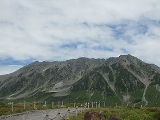
Scenery of Mount Tate
| Mt. Tate from Higashi-Ichinokoshi |
Mt. Tate from Mt. Bessan |
Mt. Tate and Mt. Tsurugi from Mt. Jii |
Mt. Tate and Mt. Tsurugi from Mt. Asahi |
|---|---|---|---|
See also
- List of mountains in Japan
- Three-thousanders (in Japan)Three-thousanders (in Japan)The following is a list of the 21 mountains in Japan whose altitudes are 3,000 metres or greater. The tallest mountain in Japan is Mount Fuji .- Geography :There are three-thousanders in the following regions:...
- Tourism in JapanTourism in JapanTourism in Japan attracted 8.3 million foreign visitors in 2008, slightly more than Singapore and Ireland. Japan has 16 World Heritage Sites, including Himeji Castle and Historic Monuments of Ancient Kyoto . Kyoto receives over 30 million tourists annually...