
Mount Michener
Encyclopedia
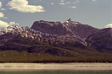
Mount Michener, with a 2545 m (8,349.7 ft) peak, is a mountain
on the eastern border of the Canadian Rockies
in Alberta
, Canada
. It forms the northerly part of the Ram Range
.
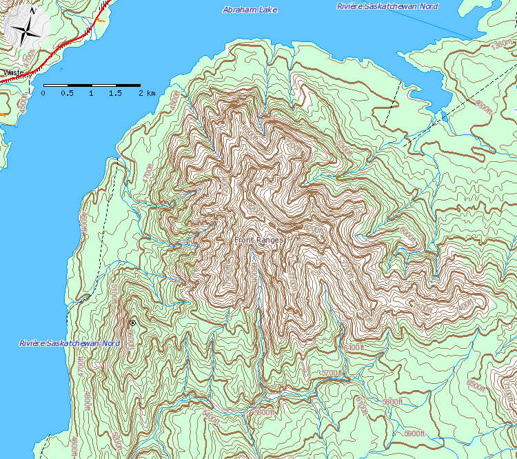
The mountain sits on the shore of Abraham Lake
and its north, west and south face are all visible from the David Thompson Highway.
The mountain was named in 1982 after Daniel Roland Michener who was the Governor General of Canada
from 1967 - 1974. Its previous names were Eye Opener Mountain and Phoebe's Teat, reportedly after a woman from Rocky Mountain House who would periodically visit the Nordegg
miners in the 1930s.
 The formation of the Rocky Mountains began in the Late Cretaceous Period and finished in the Early Tertiary Period. The pressure on the fault line caused thousands of metres of rock to thrust upward. The contorted beds near the summit of Mount Michener are visible evidence of the tremendous force that caused its formation. A system of limestone caves does exist within the mountain, but they remain undocumented.
Mountain
Image:Himalaya_annotated.jpg|thumb|right|The Himalayan mountain range with Mount Everestrect 58 14 160 49 Chomo Lonzorect 200 28 335 52 Makalurect 378 24 566 45 Mount Everestrect 188 581 920 656 Tibetan Plateaurect 250 406 340 427 Rong River...
on the eastern border of the Canadian Rockies
Canadian Rockies
The Canadian Rockies comprise the Canadian segment of the North American Rocky Mountains range. They are the eastern part of the Canadian Cordillera, extending from the Interior Plains of Alberta to the Rocky Mountain Trench of British Columbia. The southern end borders Idaho and Montana of the USA...
in Alberta
Alberta
Alberta is a province of Canada. It had an estimated population of 3.7 million in 2010 making it the most populous of Canada's three prairie provinces...
, Canada
Canada
Canada is a North American country consisting of ten provinces and three territories. Located in the northern part of the continent, it extends from the Atlantic Ocean in the east to the Pacific Ocean in the west, and northward into the Arctic Ocean...
. It forms the northerly part of the Ram Range
Ram Range
The Ram Range is a mountain range of the Canadian Rockies located in David Thompson Country, Canada. The range extends southeast from Abraham Lake to the Ram River. It is bounded on the southwest by Whiterabbit Creek....
.
The mountain sits on the shore of Abraham Lake
Abraham Lake
Abraham Lake is an artificial lake on North Saskatchewan River in western Alberta, Canada. Abraham Lake has a surface area of and a length of .-History:...
and its north, west and south face are all visible from the David Thompson Highway.
The mountain was named in 1982 after Daniel Roland Michener who was the Governor General of Canada
Governor General of Canada
The Governor General of Canada is the federal viceregal representative of the Canadian monarch, Queen Elizabeth II...
from 1967 - 1974. Its previous names were Eye Opener Mountain and Phoebe's Teat, reportedly after a woman from Rocky Mountain House who would periodically visit the Nordegg
Nordegg, Alberta
Nordegg is a hamlet in west-central Alberta, Canada within Clearwater County. It is located in the North Saskatchewan River valley in the foothills of the Canadian Rockies, at the crossroads of David Thompson Highway and the Highway 734 spur of the Bighorn Highway.- History :The community was...
miners in the 1930s.
Geography