
Monkman Provincial Park
Encyclopedia
Monkman Provincial Park is a provincial park
in British Columbia
, Canada
south of the communities of Tumbler Ridge and Chetwynd, British Columbia
and northeast of Prince George
.
, an individual who expended a considerable amount of effort attempting to build a transportation route from the Peace River (Canada)
farming country down to the Pacific ports. In 1922, he and a group of fur trappers discovered what is now known as Monkman Pass. It was this pass that provided him with his vision for a railroad as a direct and economical route south. Failing to get government support for his venture, Monkman focused on the alternative—building a highway. The Monkman Pass Highway Association was formed in 1936, and over the next three years, many determined volunteers laboured to blaze this new trail. Limited funding, harsh conditions, and the outbreak of the Second World War eventually brought the project to a halt. A railway was later built to the northwest over the Pine Pass, and Monkman’s "highway" slowly faded into historical obscurity. Today, only a few sections are visible along the Monkman Lake Trail, a route that follows parts of the original road. The Brooks Falls in Monkman Provincial Park, was named after Carl Brooks, one of the volunteers who worked along with Alex Monkman and the Highway Association. A cairn marking overlooking the falls has been placed in his honour.
Up until a few years ago, just getting to Monkman was as big an adventure as exploring the park itself. Washed out Forest Service roads with nearly a dozen creek crossings kept access limited to four-wheel-drive vehicles, and only at certain times of the year. Though still fairly rough, the gravel road has been upgraded and bridges have been built, opening up the park to almost all vehicles.
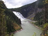
 One of the most outstanding features in Monkman Provincial Park is Kinuseo Falls
. At 197 feet (60 metres), Kinuseo Falls is slightly taller than Niagara Falls
, though it doesn't move the same volume of water as Niagara. The falls are located a short stroll from any of the campsites in the wild Rocky Mountain Foothills
. The campground is also a departure point for people making further explorations into the park.
formations, ponds and many kinds of moving water, interesting plants, fossils, and magnificent viewpoints. An interpretive brochure has been printed documenting all the areas special features.
, the trail climbs into the alpine (deviating from the original route) to a series of tarns. The route ends at Herrick Creekl, where hikers will either have to turn around and hike back, or arrange for a jetboat to pick them up. This new route is an extension of the Monkman Lake Trail.
Provincial park
A provincial park is a park under the management of a provincial or territorial government in Canada.While provincial parks are not the same as national parks, their workings are very similar...
in British Columbia
British Columbia
British Columbia is the westernmost of Canada's provinces and is known for its natural beauty, as reflected in its Latin motto, Splendor sine occasu . Its name was chosen by Queen Victoria in 1858...
, Canada
Canada
Canada is a North American country consisting of ten provinces and three territories. Located in the northern part of the continent, it extends from the Atlantic Ocean in the east to the Pacific Ocean in the west, and northward into the Arctic Ocean...
south of the communities of Tumbler Ridge and Chetwynd, British Columbia
Chetwynd, British Columbia
The District of Chetwynd is a town located on the foothills of the Rocky Mountains in northeastern British Columbia, Canada. Situated on an ancient floodplain, it is the first town eastbound travellers encounter after emerging from the Rockies along Highway 97 and acts as the gateway to the Peace...
and northeast of Prince George
Prince George, British Columbia
Prince George, with a population of 71,030 , is the largest city in northern British Columbia, Canada, and is known as "BC's Northern Capital"...
.
History
Monkman Provincial Park was named after Alexander MonkmanAlexander Monkman
Alexander Monkman was a Canadian Métis trading pioneer.- Early life :Alexander Monkman was born at Manitoba House on March 29, 1870 and grew up around Fort Garry, however he and his family fled to Edmonton after the Red River Rebellion and received his education from mission schools...
, an individual who expended a considerable amount of effort attempting to build a transportation route from the Peace River (Canada)
Peace River (Canada)
The Peace River is a river in Canada that originates in the Rocky Mountains of northern British Columbia and flows to the northeast through northern Alberta. The Peace River flows into the Slave River, a tributary of the Mackenzie River. The Mackenzie is the 12th longest river in the world,...
farming country down to the Pacific ports. In 1922, he and a group of fur trappers discovered what is now known as Monkman Pass. It was this pass that provided him with his vision for a railroad as a direct and economical route south. Failing to get government support for his venture, Monkman focused on the alternative—building a highway. The Monkman Pass Highway Association was formed in 1936, and over the next three years, many determined volunteers laboured to blaze this new trail. Limited funding, harsh conditions, and the outbreak of the Second World War eventually brought the project to a halt. A railway was later built to the northwest over the Pine Pass, and Monkman’s "highway" slowly faded into historical obscurity. Today, only a few sections are visible along the Monkman Lake Trail, a route that follows parts of the original road. The Brooks Falls in Monkman Provincial Park, was named after Carl Brooks, one of the volunteers who worked along with Alex Monkman and the Highway Association. A cairn marking overlooking the falls has been placed in his honour.
Up until a few years ago, just getting to Monkman was as big an adventure as exploring the park itself. Washed out Forest Service roads with nearly a dozen creek crossings kept access limited to four-wheel-drive vehicles, and only at certain times of the year. Though still fairly rough, the gravel road has been upgraded and bridges have been built, opening up the park to almost all vehicles.
Kinuseo Falls
Kinuseo Falls
Kinuseo Falls is a waterfall on the Murray River, which flows through the northern tip of Monkman Provincial Park in the Northern Rockies of British Columbia, Canada...
. At 197 feet (60 metres), Kinuseo Falls is slightly taller than Niagara Falls
Niagara Falls
The Niagara Falls, located on the Niagara River draining Lake Erie into Lake Ontario, is the collective name for the Horseshoe Falls and the adjacent American Falls along with the comparatively small Bridal Veil Falls, which combined form the highest flow rate of any waterfalls in the world and has...
, though it doesn't move the same volume of water as Niagara. The falls are located a short stroll from any of the campsites in the wild Rocky Mountain Foothills
Rocky Mountain Foothills
The Rocky Mountain Foothills are an upland area flanking the eastern side of the Rocky Mountains, extending south from the Liard River into Alberta. Bordering the Interior Plains system, they are part of the Rocky Mountain System or Eastern System of the Western Cordillera of North America....
. The campground is also a departure point for people making further explorations into the park.
The Stone Corral
The Stone Corral area of Monkman park was discovered in 1999. A hike to the area takes you through amazing features such as small caves with stalactites, moonsmilk and other limestoneLimestone
Limestone is a sedimentary rock composed largely of the minerals calcite and aragonite, which are different crystal forms of calcium carbonate . Many limestones are composed from skeletal fragments of marine organisms such as coral or foraminifera....
formations, ponds and many kinds of moving water, interesting plants, fossils, and magnificent viewpoints. An interpretive brochure has been printed documenting all the areas special features.
The Cascades and Monkman Lake
To the south of the Kinuseo Falls campground lies the main body of Monkman Provincial Park. Access is via the 24-km Monkman Lake Trail, which winds through this portion of the park and provides backpackers and hikers with an opportunity to experience the unspoiled splendour of the area. Small side trails provide scenic views of some of the waterfalls along Monkman Creek. The original trail ended at Monkman Lake, the largest body of water in the park, though as of 2008, the trail has been extended as part of the Monkman Pass Historical Route, but the lake is still the final destination for most people on the trail. Note that mountain bikes are only allowed up to Kilometre 12 on this trail, with horse and llama use not permitted anywhere in the park.Monkman Pass Historical Trail
Built in 2006 and 2007, the Monkman Pass Historical Trail officially opened Thursday, July 17, 2008. The trail takes six days to hike, and follows part of the old Monkman Pass Highway route. On its way to Monkman PassMonkman Pass
Monkman Pass, 1061 m , is a mountain pass in the Canadian Rockies, located southwest of the coal-mining town of Tumbler Ridge, British Columbia...
, the trail climbs into the alpine (deviating from the original route) to a series of tarns. The route ends at Herrick Creekl, where hikers will either have to turn around and hike back, or arrange for a jetboat to pick them up. This new route is an extension of the Monkman Lake Trail.
Further reading
- Helm, Charles. Tumbler Ridge: Enjoying its History, Trails, and Wilderness MCA Publishing (2001).