

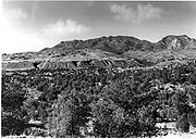
Mogollon Mountains
Encyclopedia
Mountain range
A mountain range is a single, large mass consisting of a succession of mountains or narrowly spaced mountain ridges, with or without peaks, closely related in position, direction, formation, and age; a component part of a mountain system or of a mountain chain...
east of the San Francisco River
San Francisco River
The San Francisco River is a river in the southwest United States, the largest tributary of the Upper Gila River. The river originates in Arizona and flows into New Mexico before it curves around and enters the Gila down stream from Clifton, Arizona....
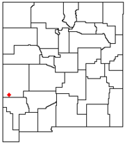
in Grant
Grant County, New Mexico
-2010:Whereas according to the 2010 U.S. Census Bureau:*84.9% White*0.9% Black*1.4% Native American*0.4% Asian*0.1% Native Hawaiian or Pacific Islander*2.8% Two or more races*9.8% Other races*48.3% Hispanic or Latino -2000:...
and Catron
Catron County, New Mexico
-2010:Whereas according to the 2010 U.S. Census Bureau:*89.8% White*0.4% Black*2.7% Native American*0.2% Asian*0.0% Native Hawaiian or Pacific Islander*3.1% Two or more races*3.7% Other races*19.0% Hispanic or Latino -2000:...
counties of southwestern New Mexico
New Mexico
New Mexico is a state located in the southwest and western regions of the United States. New Mexico is also usually considered one of the Mountain States. With a population density of 16 per square mile, New Mexico is the sixth-most sparsely inhabited U.S...
, between the communities of Reserve
Reserve, New Mexico
Reserve is a village in Catron County, New Mexico, United States. The population was 387 at the 2000 census. It is the county seat of Catron County. Currently the village has several stores, a bar, and a health clinic...
and Silver City
Silver City, New Mexico
Silver City is a town in Grant County, New Mexico, in the United States. As of the 2000 census, the town population was 10,545. It is the county seat of Grant County. The city is the home of Western New Mexico University.-History:...
. They extend roughly north-south for about 30 miles (48 km), and form part of the divide between the San Francisco and the Gila
Gila River
The Gila River is a tributary of the Colorado River, 650 miles long, in the southwestern states of New Mexico and Arizona.-Description:...
rivers. The crest of the range lies about 15 miles (24 km) east of U.S. Route 180, which traverses parallel to a section of the San Francisco River; the lower altitude smaller range, the Sierra Aguilada
Sierra Aguilada
The Sierra Aguilada is a short, higher altitude mountain range in southwest Catron County, New Mexico on the eastern perimeter of Arizona's White Mountains. The region is at the east perimeter of the Arizona transition zone with its Mogollon Rim. The Mogollon Mountains of New Mexico lie just east,...
borders to the west of Route 180. Most of the Mogollon Mountains is protected within the Gila Wilderness
Gila Wilderness
Gila Wilderness was designated the world's first wilderness area on June 3, 1924. Along with Aldo Leopold Wilderness and Blue Range Wilderness, the wilderness is part of New Mexico's Gila National Forest. The wilderness is approximately from north to south and east to west...
, part of the Gila National Forest
Gila National Forest
The Gila National Forest is a protected national forest in New Mexico in the southwestern United States established in 1905. It covers approximately 3.3 million acres of public land, making it the sixth largest National Forest in the continental United States...
.
The highest point in the range is Whitewater Baldy
Whitewater Baldy
Whitewater Baldy is the highest point of the Mogollon Mountains in the southwestern part of the US state of New Mexico. It is also the highest point in the entire southwest portion of New Mexico . It is located in Catron County in the Gila Wilderness, part of the Gila National Forest...
which, at 10,895 ft (3,321 m), is the highest point in southwestern New Mexico. The range also contains five other 10,000+ foot peaks, most notably Mogollon Baldy
Mogollon Baldy
Mogollon Baldy is one of the tallest mountains in the Mogollon Mountains of New Mexico in the United States. It is about 10,770 feet tall.-References:...
(10,778 ft, 3,285 m).
The Mogollon Mountains were formed between forty and twenty-five million years ago as part of the Datil-Mogollon
Mogollon-Datil volcanic field
The Mogollon-Datil volcanic field is a large silicic volcanic field in western New Mexico . It is a part of an extensive Eocene to Oligocene volcanic event which includes the San Juan volcanic field in southwestern Colorado, the Trans-Pecos volcanic field in west Texas and north central Mexico, the...
Volcanic
Volcano
2. Bedrock3. Conduit 4. Base5. Sill6. Dike7. Layers of ash emitted by the volcano8. Flank| 9. Layers of lava emitted by the volcano10. Throat11. Parasitic cone12. Lava flow13. Vent14. Crater15...
Plateau. Hot spring
Hot spring
A hot spring is a spring that is produced by the emergence of geothermally heated groundwater from the Earth's crust. There are geothermal hot springs in many locations all over the crust of the earth.-Definitions:...
s existing in the area are a remnant of that volcanic activity. The Mogollon Mountains are named for Juan Ignacio Flores Mogollón, governor of Nuevo Leon
Nuevo León
Nuevo León It is located in Northeastern Mexico. It is bordered by the states of Tamaulipas to the north and east, San Luis Potosí to the south, and Coahuila to the west. To the north, Nuevo León has a 15 kilometer stretch of the U.S.-Mexico border adjacent to the U.S...
1712 to 1715.
Early inhabitants of the range include the Mimbres Culture, from 300 BC to AD 1300. Later peoples included the Chiricahua and Mimbres bands of the Apache
Apache
Apache is the collective term for several culturally related groups of Native Americans in the United States originally from the Southwest United States. These indigenous peoples of North America speak a Southern Athabaskan language, which is related linguistically to the languages of Athabaskan...
, including Geronimo
Geronimo
Geronimo was a prominent Native American leader of the Chiricahua Apache who fought against Mexico and the United States for their expansion into Apache tribal lands for several decades during the Apache Wars. Allegedly, "Geronimo" was the name given to him during a Mexican incident...
, said to have been born in the area around 1829. Mining occurred in the area beginning in the 1890s and continuing for some decades.
The Mogollon Mountains should not be confused with the Mogollon Rim
Mogollon Rim
The Mogollon Rim is a topographical and geological feature running across the U.S. state of Arizona. It extends approximately from northern Yavapai County eastward to near the border with New Mexico.-Description:...
, a large escarpment
Escarpment
An escarpment is a steep slope or long cliff that occurs from erosion or faulting and separates two relatively level areas of differing elevations.-Description and variants:...
in Arizona, about 100 miles (160.9 km) to the northwest.