

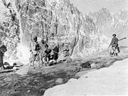
Mintaka Pass
Encyclopedia
Pakistan
Pakistan , officially the Islamic Republic of Pakistan is a sovereign state in South Asia. It has a coastline along the Arabian Sea and the Gulf of Oman in the south and is bordered by Afghanistan and Iran in the west, India in the east and China in the far northeast. In the north, Tajikistan...
and Xinjiang
Xinjiang
Xinjiang is an autonomous region of the People's Republic of China. It is the largest Chinese administrative division and spans over 1.6 million km2...
in China
China
Chinese civilization may refer to:* China for more general discussion of the country.* Chinese culture* Greater China, the transnational community of ethnic Chinese.* History of China* Sinosphere, the area historically affected by Chinese culture...
. In ancient times, the Mintaka Pass and the nearby Kilik Pass
Kilik Pass
The Kilik Pass , to the west of Mintaka Pass is a high mountain pass in the Karakorum Mountains between Pakistan-administered Kashmir and Xinjiang in the People's Republic of China. The two passes were, in ancient times, the two main access points into the Upper Hunza Valley from the north...
(4827 m or 15,836.6 ft high; 37°05′N 74°41′E), 30 km (18.6 mi) to the west, were the two main access points into the Upper Hunza Valley
Hunza Valley
The Hunza Valley is a mountainous valley in the Gilgit-Baltistan region of Pakistan. The Hunza valley is situated to the north of the Hunza River, at an elevation of around . The territory of Hunza is about...
from the north. The Hunza Valley is a mountainous valley near Gilgit
Gilgit Valley
Gilgit Valley is located in Gilgit, Pakistan. The Gilgit River flows here. 375 km of road connect it to Chitral via the Shandur Pass ....
in the Northern Areas
Northern Areas
Gilgit-Baltistan , is the northernmost political entity within Pakistan. It borders Pakistan's Khyber Pukhtunkhwa province to the west, Afghanistan's Wakhan Corridor to the north, China to the east and northeast, Azad Kashmir to the southwest, and Indian-administered Jammu and Kashmir to the...
of Pakistan
Pakistan
Pakistan , officially the Islamic Republic of Pakistan is a sovereign state in South Asia. It has a coastline along the Arabian Sea and the Gulf of Oman in the south and is bordered by Afghanistan and Iran in the west, India in the east and China in the far northeast. In the north, Tajikistan...
.
These were the shortest and quickest ways into northern India from the Tarim Basin
Tarim Basin
The Tarim Basin is a large endorheic basin occupying an area of about . It is located in the Xinjiang Uyghur Autonomous Region in China's far west. Its northern boundary is the Tian Shan mountain range and its southern is the Kunlun Mountains on the northern edge of the Tibetan Plateau. The...
and were usually open all year, but extremely dangerous and only suited for travellers on foot. From Tashkurgan
Tashkurgan
- Karakoram Highway :Today Tashkurgan is on the Karakoram Highway which follows the old Silk Road route from China to Pakistan. Accommodation is available and it is a recommended overnight stop for road travellers from China to Pakistan in order to have the best chance of crossing the snow-prone...
one travelled just over 70 km (43.5 mi) south to the junction of the Minteke River. Heading some 80 km (49.7 mi) west up this valley one reached the Mintaka Pass, (and 30 km further, the alternative Kilik Pass), which both led into upper Hunza, from where one could travel over the infamous rafiqs or "hanging passages" to Gilgit
Gilgit
Gilgit is a city in northern PakistanGilgit may refer to other terms related with the area of the city:* Gilgit River* Gilgit Valley* Gilgit District* Gilgit Agency * Gilgit Airport...
and, from there, on to either to Kashmir, or the Gandharan plains.
Laden animals could be taken over the Mintaka and Kilik passes into upper Hunza
Hunza Valley
The Hunza Valley is a mountainous valley in the Gilgit-Baltistan region of Pakistan. The Hunza valley is situated to the north of the Hunza River, at an elevation of around . The territory of Hunza is about...
(both open all year), but then loads would have to be carried by coolie
Coolie
Historically, a coolie was a manual labourer or slave from Asia, particularly China, India, and the Phillipines during the 19th century and early 20th century...
(porters) to Gilgit
Gilgit
Gilgit is a city in northern PakistanGilgit may refer to other terms related with the area of the city:* Gilgit River* Gilgit Valley* Gilgit District* Gilgit Agency * Gilgit Airport...
(an expensive and dangerous operation). From there, cargoes could be reloaded onto pack animals again and taken either east to Kashmir
Kashmir
Kashmir is the northwestern region of the Indian subcontinent. Until the mid-19th century, the term Kashmir geographically denoted only the valley between the Great Himalayas and the Pir Panjal mountain range...
and then on to Taxila
Taxila
Taxila is a Tehsil in the Rawalpindi District of Punjab province of Pakistan. It is an important archaeological site.Taxila is situated about northwest of Islamabad Capital Territory and Rawalpindi in Panjab; just off the Grand Trunk Road...
(a long route), or west to Chitral
Chitral
Chitral or Chetrar , translated as field in the native language Khowar, is the capital of the Chitral District, situated on the western bank of the Kunar River , in Pakistan. The town is at the foot of Tirich Mir, the highest peak of the Hindu Kush, high...
which provided relatively easy access to either Jalalabad, or Peshawar
Peshawar
Peshawar is the capital of Khyber-Pakhtunkhwa and the administrative center and central economic hub for the Federally Administered Tribal Areas of Pakistan....
via Swat
Swat (Pakistan)
Swat is a valley and an administrative district in the Khyber Pakhtunkhwa Province, located close to the Afghan-Pakistan border. It is the upper valley of the Swat River, which rises in the Hindu Kush range. The capital of Swat is Saidu Sharif, but the main town in the Swat valley is Mingora...
.
The Mintaka Pass was the main one used in ancient times until the fairly recent advance of glacier ice. After the glaciation of the Mintaka Pass, the Kilik Pass was favoured by caravans coming from China and Afghanistan as it is wider, free of glaciers and provided enough pasture for caravan animals.
The new Karakoram Highway
Karakoram Highway
The Karakoram Highway is the highest paved international road in the world, but at its peak at the China-Pakistan border it is only paved on the Chinese side. It connects China and Pakistan across the Karakoram mountain range, through the Khunjerab Pass, at an altitude of as confirmed by both...
heads further south, and then west over the Khunjerab Pass
Khunjerab Pass
Khunjerab Pass is a high mountain pass in the Karakoram Mountains in a strategic position on the northern border of Pakistan's Gilgit-Baltistan region within the disputed region of Kashmir and on the southwest border of the Xinjiang region of China...
(4934 m or 16,187.7 ft; 36°51′N 75°32′E).