
Mindanao River
Encyclopedia
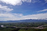
The Mindanao River, also known as the Rio Grande de Mindanao, is the second largest river system in the Philippines
, after the Cagayan River
of Luzon
. It is also the largest river
on the southern Philippine
island of Mindanao
having a drainage area of 23,169 square kilometers, draining majority of the central and eastern portion of the island. It is also the second longest river in the country
with a length of approximately 373 km (231.8 mi). It is an important transportation artery on the island, used mainly in transporting agricultural products and, formerly, timber
.
Its headwaters are in the mountains of Impasug-ong
, Bukidnon
, south of Gingoog City
in Misamis Oriental
, where it is called the Pulangi River
. Joining the Kabacan River, it becomes the Mindanao River. Flowing out of the mountains, it forms the center of a broad, fertile plain in the south-central portion of the island. Before its mouth in the Moro Gulf
, it splits into two parallel sections, the Cotabato and Tamentaka, separated by a 180 m (600 ft) hill.
Population centers along the river include Cotabato City
, Datu Piang
, and Midsayap.
, where it is known as the Pulangi River
. It then flows southward across the Bukidnon Plateau, fed up by its tributaries along the way and then emerges onto the Cotabato plains, depositing fertile mountain silt as it widens and arcs westward through the 1000 square miles (2,590 km²) Cotabato River Basin. It finally empties into Illana Bay
at its mouth in Cotabato City
.
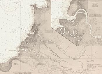
, it branches out into two distributaries, the Cotabato in the north and the Tamontaka in the south at Cotabato City
.
, causing it to overflow after days of heavy rain. Floodwaters submerged at least 37 villages in Cotabato City alone and displaced some 6,000 families.
President Benigno Aquino III
ordered public works and military personnel to clear the river of up to 20 hectares of water lily growth.
Philippines
The Philippines , officially known as the Republic of the Philippines , is a country in Southeast Asia in the western Pacific Ocean. To its north across the Luzon Strait lies Taiwan. West across the South China Sea sits Vietnam...
, after the Cagayan River
Cagayan River
The Cagayan River is the longest and largest river in the Philippine Archipelago. It is located in the Cagayan Valley region in northeastern part of Luzon island and traverses the provinces of Nueva Vizcaya, Quirino, Isabela and Cagayan.-Topography:...
of Luzon
Luzon
Luzon is the largest island in the Philippines. It is located in the northernmost region of the archipelago, and is also the name for one of the three primary island groups in the country centered on the Island of Luzon...
. It is also the largest river
River
A river is a natural watercourse, usually freshwater, flowing towards an ocean, a lake, a sea, or another river. In a few cases, a river simply flows into the ground or dries up completely before reaching another body of water. Small rivers may also be called by several other names, including...
on the southern Philippine
Philippines
The Philippines , officially known as the Republic of the Philippines , is a country in Southeast Asia in the western Pacific Ocean. To its north across the Luzon Strait lies Taiwan. West across the South China Sea sits Vietnam...
island of Mindanao
Mindanao
Mindanao is the second largest and easternmost island in the Philippines. It is also the name of one of the three island groups in the country, which consists of the island of Mindanao and smaller surrounding islands. The other two are Luzon and the Visayas. The island of Mindanao is called The...
having a drainage area of 23,169 square kilometers, draining majority of the central and eastern portion of the island. It is also the second longest river in the country
Philippines
The Philippines , officially known as the Republic of the Philippines , is a country in Southeast Asia in the western Pacific Ocean. To its north across the Luzon Strait lies Taiwan. West across the South China Sea sits Vietnam...
with a length of approximately 373 km (231.8 mi). It is an important transportation artery on the island, used mainly in transporting agricultural products and, formerly, timber
Timber
Timber may refer to:* Timber, a term common in the United Kingdom and Australia for wood materials * Timber, Oregon, an unincorporated community in the U.S...
.
Its headwaters are in the mountains of Impasug-ong
Impasug-Ong, Bukidnon
Impasug-ong is a 1st class municipality in the province of Bukidnon, Philippines. According to the 2000 census, it has a population of 31,173 people in 5,718 households.-Location and General Physical Characteristics:...
, Bukidnon
Bukidnon
Bukidnon is a landlocked province of the Philippines located in the Northern Mindanao region. Its capital is Malaybalay City. The province borders, clockwise starting from the north, Misamis Oriental, Agusan del Sur, Davao del Norte, Cotabato, Lanao del Sur, and Lanao del Norte.Bukidnon is...
, south of Gingoog City
Gingoog City
The City of Gingoog is a third class city in the Province of Misamis Oriental. Pronounced as Hingoog due to Spanish accent of G to H...
in Misamis Oriental
Misamis Oriental
Misamis Oriental is a province of the Philippines located in the Northern Mindanao region. Its capital and provincial center is Cagayan de Oro City...
, where it is called the Pulangi River
Pulangi River
The Pulangi River , also spelled Pulangui, is the longest river in Bukidnon. It is one of the major tributaries of the Rio Grande de Mindanao, an extensive river system in Mindanao, Philippines...
. Joining the Kabacan River, it becomes the Mindanao River. Flowing out of the mountains, it forms the center of a broad, fertile plain in the south-central portion of the island. Before its mouth in the Moro Gulf
Moro Gulf
The Moro Gulf is a sea in Mindanao in the Philippines. It is part of Celebes Sea and is surrounded by the Zamboanga Peninsula and the central part of Mindanao. Sibuguey Bay and Illana Bay are its major branches. Zamboanga City is the most important port city on its coast...
, it splits into two parallel sections, the Cotabato and Tamentaka, separated by a 180 m (600 ft) hill.
Population centers along the river include Cotabato City
Cotabato City
The City of Cotabato is one of the cities of the Philippines located in Mindanao. Cotabato City is an exclave of the SOCCSKSARGEN region found within the boundaries of Maguindanao province, but is independent of that province...
, Datu Piang
Datu Piang
Piang popularly known as Datu Piang was a Maguindanao leader, often referred to as the Grand Old Man of Cotabato....
, and Midsayap.
Course
The Mindanao River has its source in the Central Mindanao Highlands near the northern coast of the island, specifically on the northeastern part of the province of BukidnonBukidnon
Bukidnon is a landlocked province of the Philippines located in the Northern Mindanao region. Its capital is Malaybalay City. The province borders, clockwise starting from the north, Misamis Oriental, Agusan del Sur, Davao del Norte, Cotabato, Lanao del Sur, and Lanao del Norte.Bukidnon is...
, where it is known as the Pulangi River
Pulangi River
The Pulangi River , also spelled Pulangui, is the longest river in Bukidnon. It is one of the major tributaries of the Rio Grande de Mindanao, an extensive river system in Mindanao, Philippines...
. It then flows southward across the Bukidnon Plateau, fed up by its tributaries along the way and then emerges onto the Cotabato plains, depositing fertile mountain silt as it widens and arcs westward through the 1000 square miles (2,590 km²) Cotabato River Basin. It finally empties into Illana Bay
Illana Bay
Illana Bay is a large bay in the southwestern part of Mindanao island, Philippines, at ....
at its mouth in Cotabato City
Cotabato City
The City of Cotabato is one of the cities of the Philippines located in Mindanao. Cotabato City is an exclave of the SOCCSKSARGEN region found within the boundaries of Maguindanao province, but is independent of that province...
.
River Delta
As the Mindanao River meets Illana BayIllana Bay
Illana Bay is a large bay in the southwestern part of Mindanao island, Philippines, at ....
, it branches out into two distributaries, the Cotabato in the north and the Tamontaka in the south at Cotabato City
Cotabato City
The City of Cotabato is one of the cities of the Philippines located in Mindanao. Cotabato City is an exclave of the SOCCSKSARGEN region found within the boundaries of Maguindanao province, but is independent of that province...
.
Water hyacinths
The river has recently been clogged with water hyacinthsWater hyacinth
The seven species of water hyacinth comprise the genus Eichhornia. Water hyacinth are a free-floating perennial aquatic plant native to tropical and sub-tropical South America. With broad, thick, glossy, ovate leaves, water hyacinth may rise above the surface of the water as much as 1 meter in...
, causing it to overflow after days of heavy rain. Floodwaters submerged at least 37 villages in Cotabato City alone and displaced some 6,000 families.
President Benigno Aquino III
Benigno Aquino III
Benigno Simeon Cojuangco Aquino III , also known as Noynoy Aquino or PNoy, is a Filipino politician who has been the 15th and current President of the Philippines since June 2010....
ordered public works and military personnel to clear the river of up to 20 hectares of water lily growth.