

Michigan Road
Encyclopedia
Indiana
Indiana is a US state, admitted to the United States as the 19th on December 11, 1816. It is located in the Midwestern United States and Great Lakes Region. With 6,483,802 residents, the state is ranked 15th in population and 16th in population density. Indiana is ranked 38th in land area and is...
. Roads in early Indiana were often roads in name only. In actuality they were sometimes little more than crude paths following old animal and Native American trails and filled with sinkholes, stumps, and deep, entrapping ruts. Hoosier leaders, however, recognized the importance of roads to the growth and economic health of the state, and the needed improvements
Internal improvements
Internal improvements is the term used historically in the United States for public works from the end of the American Revolution through much of the 19th century, mainly for the creation of a transportation infrastructure: roads, turnpikes, canals, harbors and navigation improvements...
. They encouraged construction of roads which would do for Indiana what the National Road
National Road
The National Road or Cumberland Road was the first major improved highway in the United States to be built by the federal government. Construction began heading west in 1811 at Cumberland, Maryland, on the Potomac River. It crossed the Allegheny Mountains and southwestern Pennsylvania, reaching...
was doing for the whole country.
As early as 1821 the legislature earmarked funds for more than two dozen roads throughout the state. Roadbuilding was often the responsibility of the counties, which were empowered to call out a local labor force for construction and provide road viewers, or supervisors.
History
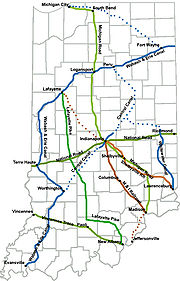
Indiana's first "super highway" was the Michigan Road, which was built in the 1830s and 1840s and ran from Madison, IndianaMadison, Indiana
As of the census of 2000, there were 12,004 people, 5,092 households, and 3,085 families residing in the city. The population density was 1,402.9 people per square mile . There were 5,597 housing units at an average density of 654.1 per square mile...
to Michigan City, Indiana
Michigan City, Indiana
Michigan City's origins date to 1830, when the land for the city was first purchased by Isaac C. Elston. Elston Middle School, formerly Elston High School, located at 317 Detroit St., is named after the founder....
via Indianapolis
Indianapolis
Indianapolis is the capital of the U.S. state of Indiana, and the county seat of Marion County, Indiana. As of the 2010 United States Census, the city's population is 839,489. It is by far Indiana's largest city and, as of the 2010 U.S...
. Like the National Road, it did much to spur settlement and economic growth. One-half of the pioneers to settle northwestern Indiana did so by using the Michigan Road to travel from the Ohio River to their destination. It was the "most ambitious" project to connect Indianapolis with the rest of the state, despite being never more than a "muddy road".
One of the things that made the road possible was a treaty the state of Indiana forged with the Pottawatomie on October 16, 1826. Governor
Governor of Indiana
The Governor of Indiana is the chief executive of the state of Indiana. The governor is elected to a four-year term, and responsible for overseeing the day-to-day management of the functions of many agencies of the Indiana state government. The governor also shares power with other statewide...
James B. Ray
James B. Ray
James Brown Ray was an Indiana politician and the only Senate President-Pro-Tempore to succeed to become Governor of the State of Indiana. He served during the period when the state transitioned from personal politics to political parties, but never joined a party himself. Elevated at age 31, he...
led the negotiations. It allowed for a ribbon of land 100 feet (30.5 m) wide to stretch from the Ohio River
Ohio River
The Ohio River is the largest tributary, by volume, of the Mississippi River. At the confluence, the Ohio is even bigger than the Mississippi and, thus, is hydrologically the main stream of the whole river system, including the Allegheny River further upstream...
(at Madison) to Lake Michigan
Lake Michigan
Lake Michigan is one of the five Great Lakes of North America and the only one located entirely within the United States. It is the second largest of the Great Lakes by volume and the third largest by surface area, after Lake Superior and Lake Huron...
(Michigan City). The Pottawatomie left the region by the very road when the last of their tribe was forcibly removed in the 1836 Pottawatomie Trail of Death.
Kankakee River
The Kankakee River is a tributary of the Illinois River, approximately long, in northwestern Indiana and northeastern Illinois in the United States. At one time the river drained one of the largest wetlands in North America and furnished a significant portage between the Great Lakes and the...
's swamp posed a problem for the construction of the road, forcing the commission to avoid a more direct northwesterly route and instead have it go from Logansport, Indiana
Logansport, Indiana
Logansport is a city in and the county seat of Cass County, Indiana, United States. The population was 18,396 at the 2010 census. Logansport is located in northern Indiana, at the junction of the Wabash and Eel rivers, northeast of Lafayette.-History:...
straight up to the south bend of the St Joseph River (now South Bend, Indiana
South Bend, Indiana
The city of South Bend is the county seat of St. Joseph County, Indiana, United States, on the St. Joseph River near its southernmost bend, from which it derives its name. As of the 2010 Census, the city had a total of 101,168 residents; its Metropolitan Statistical Area had a population of 316,663...
), and then west to Lake Michigan. Michigan City was formally selected to be the trailend in 1832.
The route from Madison to Indianapolis was straighter. From Madison it went north through Ripley and Jefferson counties straight to Napoleon, Indiana
Napoleon, Indiana
Napoleon is a town in Jackson Township, Ripley County, Indiana, United States. The population was 234 at the 2010 census.-Geography:Napoleon is located at ....
, and from there straight through Shelby County, Indiana
Shelby County, Indiana
As of the census of 2000, there were 43,445 people, 16,561 households, and 12,056 families residing in the county. The population density was 105 people per square mile . There were 17,633 housing units at an average density of 43 per square mile...
to Indianapolis.
It proved to be the preferred route to Indianapolis for 34 separate counties, even through the road only went through 14 counties. In 1836 the Indiana General Assembly
Indiana General Assembly
The Indiana General Assembly is the state legislature, or legislative branch, of the state of Indiana. It is a bicameral legislature that consists of a lower house, the Indiana House of Representatives, and an upper house, the Indiana Senate...
passed the Mammoth Internal Improvement Act
Indiana Mammoth Internal Improvement Act
The Indiana Mammoth Internal Improvement Act was a bipartisan law passed by the Indiana General Assembly and signed by Whig Governor Noah Noble in 1836 that greatly expanded the state's program of internal improvements. It added an additional $10 million to spending and funded several projects,...
, the act provided funds to pave
Macadam
Macadam is a type of road construction pioneered by the Scotsman John Loudon McAdam in around 1820. The method simplified what had been considered state-of-the-art at that point...
the entire length of the road. However, the economic difficulties brought on by overspending and the Panic of 1837
Panic of 1837
The Panic of 1837 was a financial crisis or market correction in the United States built on a speculative fever. The end of the Second Bank of the United States had produced a period of runaway inflation, but on May 10, 1837 in New York City, every bank began to accept payment only in specie ,...
caused the state to enter partial bankruptcy before the entire length could be paved. The situation forced Indiana to give control of the road to the individual counties as part of a plan to avoid losing it to the state's creditors.
Today
Indiana State Road 29Indiana State Road 29
-Route description:The southern terminus of State Road 29 is at U.S. Route 421 and State Road 28 just south of the small town of Boyleston. Going north, it passes through Michigantown in Clinton County, then along the eastern border of Carroll County where it passes through Burlington. Its...
, originally much longer, followed the route from Madison to Bryantsburg, and from Napoleon in the south to Logansport in the north. Indiana State Road 25
Indiana State Road 25
State Road 25 is a highway in the U. S. state of Indiana. Although it is designated a north–south road, in practice it travels generally northeast from its southern terminus at State Road 32 to its northern terminus at State Road 15 in Warsaw.- Waynetown to Lafayette :SR 25 heads north...
followed the original route to Rochester, Indiana
Rochester, Indiana
Rochester is a city in and the county seat of Fulton County, Indiana, United States. The population was 6,414 at the 2000 census.-Geography:Rochester is located at ....
. U.S. Route 31
U.S. Route 31
U.S. Route 31 is a long north–south highway connecting northern Michigan to southern Alabama, with its northern terminus at Interstate 75 near Mackinaw City, Michigan, and southern terminus at the combined U.S. Route 90 & U.S. Route 98 at Spanish Fort, Alabama...
followed the original route from Rochester to South Bend, Indiana
South Bend, Indiana
The city of South Bend is the county seat of St. Joseph County, Indiana, United States, on the St. Joseph River near its southernmost bend, from which it derives its name. As of the 2010 Census, the city had a total of 101,168 residents; its Metropolitan Statistical Area had a population of 316,663...
. Indiana State Road 2
Indiana State Road 2
State Road 2 in the U.S. State of Indiana is an east–west route running from the Illinois border at Illinois Route 17 east to the outskirts of South Bend, Indiana at the U.S. Route 20/U.S. Route 31 freeway, also known as the St. Joseph Valley Parkway...
and U.S. Route 20
U.S. Route 20
U.S. Route 20 is an east–west United States highway. As the "0" in its route number implies, US 20 is a coast-to-coast route. Spanning , it is the longest road in the United States, and the route sparsely parallels Interstate 90...
follow the original road from South Bend to Michigan City.
The later U.S. Route 421
U.S. Route 421
U.S. Route 421 is a spur route of U.S. 21. It runs for from Michigan City, Indiana, at U.S. 20, to Fort Fisher in North Carolina. The highway goes through the cities of Indianapolis, Indiana, Lexington, Kentucky, Boone, North Carolina, Winston-Salem, North Carolina, Greensboro, North Carolina and...
replaced Indiana State Road 29 from Madison to near Boyleston; the original route for US 421 was altered when Interstate 465
Interstate 465
Interstate 465 , also known as the USS Indianapolis Memorial Highway, is the beltway circling Indianapolis, Indiana, United States. It is roughly rectangular in shape and has a perimeter of approximately 53 miles . It lies almost completely within the boundaries of Marion County, except for two...
was constructed. A more "truck friendly" route was also built from Madison to North Madison. (The section of US 421 from Bryantsburg to Napoleon through Versailles was originally made SR 29 to conform with the law creating the state highway system in 1919.)
The original US 31 has been bypassed in several locations, most notably, in terms of the Michigan Road, from Rochester to north of Plymouth, Indiana
Plymouth, Indiana
-Demographics:As of the census of 2000, there were 9,840 people, 3,838 households, and 2,406 families residing in the city. The population density was 1,414.0 people per square mile . There were 4,100 housing units at an average density of 589.2 per square mile...
. SR 29 from the south into Logansport has been decommissioned, as has the entire route (that which remains) from north of Greensburg (JCT I-74/US 421) to the northwest side of Indianapolis (JCT I-465/US 421).
In Indianapolis, a few remnants of the road still remain. In particular stands a tollhouse the Augusta Gravel Road Company placed to recoup their costs in repairing the road. It stands just north of the White River
White River (Indiana)
The White River is a two-forked river that flows through central and southern Indiana and is the main tributary to the Wabash River. Via the west fork, considered to be the main stem of the river by the U.S. Board on Geographic Names, the White River is long.-West Fork:The West Fork, long, is...
.
A monument marking the intersection of the Michigan Road and the National Road exists at the corner of Washington Street
Washington Street (Indianapolis)
Washington Street is the primary east-west street in Indianapolis, Indiana, United States. The street follows the route of the National Road for almost all of its length in the city of Indianapolis. For a time, its entire length was designated as U.S...
and Southeastern Ave. near downtown Indianapolis. This monument was relocated slightly as part of the changes to Interstate 65
Interstate 65
Interstate 65 is a major Interstate Highway in the United States. The southern terminus is located at an intersection with Interstate 10 in Mobile, Alabama, and its northern terminus is at an interchange with Interstate 90 , U.S. Route 12, and U.S...
exits in 2008.
Historical markers
Michigan Road related markers in Indiana include:Boone County, Indiana
Boone County, Indiana
As of the census of 2000, there were 46,107 people, 17,081 households, and 12,810 families residing in the county. The population density was 109 people per square mile . There were 17,929 housing units at an average density of 42 per square mile...
: MICHIGAN ROAD - With proceeds from the sale of 170580 acres (690.3 km²) of Indian land granted by the Federal Government, Indiana built its first north-south road. Surveyed 1829, passable by 1834, "completed" in 1837, its cost was $242,000.00. http://www.in.gov/history/markers/49.htm (Location: West side of US 421, north of 121st Street, north & east of Zionsville.)
Fulton County, Indiana
Fulton County, Indiana
As of the census of 2000, there were 20,511 people, 8,082 households, and 5,738 families residing in the county. The population density was 56 people per square mile . There were 9,123 housing units at an average density of 25 per square mile...
: MICHIGAN ROAD - Extending from Michigan City to the Ohio River at Madison. Begun by the state in 1832 with funds obtained from sale of land granted by the Potawatomi Indians. Opened northern part of state to settlers. http://www.in.gov/history/markers/102.htm (Location: Old US 31 at Tippecanoe River bridge, SE corner, 3 miles (4.8 km) north of Rochester.)
Marion County, Indiana
Marion County, Indiana
Marion County is a county located in the U.S. state of Indiana. Census 2010 recorded a population of 903,393, making it the largest county in the state and 55th most populated county in the country, greater than the population of six states. The county seat is Indianapolis, the state capital and...
: TOLL HOUSE - Operated by Augusta Gravel Road Co., circa 1866-1892. MICHIGAN ROAD - First major state road, built in the 1830's, from the Ohio River to Lake Michigan. http://www.in.gov/history/markers/193.htm (Location: 4702 N. Michigan Road/Old US 421, Indianapolis.)
Ripley County, Indiana
Ripley County, Indiana
As of the census of 2000, there were 26,523 people, 9,842 households, and 7,273 families residing in the county. The population density was 59 people per square mile . There were 10,482 housing units at an average density of 24 per square mile...
: MICHIGAN ROAD - Extending from Michigan City to the Ohio River at Madison. Begun by the state in 1832 with funds obtained from sale of land granted by the Potawatomi Indians. Opened northern part of state to settlers. http://www.in.gov/history/markers/275.htm (Location: US 50 and N. Old Michigan Road, 2 miles (3.2 km) east of Holton.)
See also
- Buffalo Trace (road)Buffalo Trace (road)The Buffalo Trace was a trackway running through what are now the American states of Kentucky, Indiana, and Illinois. Originally formed by migrating bison, the trace crossed the Ohio River near the Falls of the Ohio and the Wabash River near Vincennes...
- Michigan Avenue or the Chicago Road, an early road connecting Detroit and Chicago
- National RoadNational RoadThe National Road or Cumberland Road was the first major improved highway in the United States to be built by the federal government. Construction began heading west in 1811 at Cumberland, Maryland, on the Potomac River. It crossed the Allegheny Mountains and southwestern Pennsylvania, reaching...