
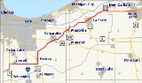
Indiana State Road 2
Encyclopedia
State Road 2 in the U.S. State
of Indiana
is an east–west route running from the Illinois
border at Illinois Route 17
east to the outskirts of South Bend, Indiana
at the U.S. Route 20
/U.S. Route 31 freeway, also known as the St. Joseph Valley Parkway
. This is a distance of 80.98 miles (130.3 km).
(US 41) and is concurrent with US 41 for 2.64 miles (4.2 km). It then heads east toward Lowell
; beyond Lowell there is a short concurrency with State Road 55
(SR 55), followed by an interchange
with Interstate 65
(I-65) at exit number 240. About 4 miles (6.4 km) to the east, SR 2 joins U.S. Route 231 (US 231) and they are concurrent for 2.17 miles (3.5 km). After SR 2 leaves US 231 it heads north-northeast toward Valparaiso.
(US 30). At the State Road 49
(SR 49) exit, SR 2 joins SR 49 north. Soon after SR 2 leaves SR 49 and heads northeast toward LaPorte
. Passing though Westville
, there is a short concurrency with U.S. Route 421
(US 421).
(SR 39). In downtown LaPorte SR 2 has an intersection
with U.S. Route 35 (US 35); here, SR 39 is concurrent with US 35. From this point, SR 2 is a four-lane divided highway. SR 2 heads northeast from LaPorte to Rolling Prairie
where it meets US 20. Here, US 20 and SR 2 switch alignments at a lighted intersection; US 20 follows the north and west legs of the intersection, while SR 2 follows the south and east legs. On the west side of South Bend, SR 2 ends at an interchange with US 20 and U.S. Route 31 (US 31).
(Interstate 80
/Interstate 90) and by US 20. SR 2 appears to be part of an old alignment from Kankakee, Illinois
to South Bend and runs more diagonally than other east–west state highways in Indiana.
In Valparaiso
, SR 2 has been rerouted around the downtown and central business districts of the city. Instead of traveling through the city along Washington Street, SR 2 shares portions of the routes of US 30 and the Valparaiso Bypass (SR 49).
Several times in its history, SR 2 has run along the path of the Lincoln Highway
.
area, SR 2 continued to downtown South Bend, mostly along Western Avenue (which remains, but no longer has state highway markers). SR 2 originally followed the Lincoln Highway
to Fort Wayne
before U.S. Route 33
(US 33) supplanted it east of downtown South Bend. Part of SR 2's former routing is now State Road 933 (SR 933).
U.S. state
A U.S. state is any one of the 50 federated states of the United States of America that share sovereignty with the federal government. Because of this shared sovereignty, an American is a citizen both of the federal entity and of his or her state of domicile. Four states use the official title of...
of Indiana
Indiana
Indiana is a US state, admitted to the United States as the 19th on December 11, 1816. It is located in the Midwestern United States and Great Lakes Region. With 6,483,802 residents, the state is ranked 15th in population and 16th in population density. Indiana is ranked 38th in land area and is...
is an east–west route running from the Illinois
Illinois
Illinois is the fifth-most populous state of the United States of America, and is often noted for being a microcosm of the entire country. With Chicago in the northeast, small industrial cities and great agricultural productivity in central and northern Illinois, and natural resources like coal,...
border at Illinois Route 17
Illinois Route 17
Illinois Route 17 is a rural, arterial east–west state road that runs east from a former ferry crossing in New Boston along the banks of the Mississippi River to State Road 2 west of Lowell, Indiana. It is long.- Route description :...
east to the outskirts of South Bend, Indiana
South Bend, Indiana
The city of South Bend is the county seat of St. Joseph County, Indiana, United States, on the St. Joseph River near its southernmost bend, from which it derives its name. As of the 2010 Census, the city had a total of 101,168 residents; its Metropolitan Statistical Area had a population of 316,663...
at the U.S. Route 20
U.S. Route 20 in Indiana
U.S. Route 20 in Indiana is a main east–west highway that is parallel to the Indiana Toll Road. The western terminus of US 20 is at the Illinois state line and the eastern terminus is at the Ohio state line. US 20 through Whiting, East Chicago, and Gary is concurrent with...
/U.S. Route 31 freeway, also known as the St. Joseph Valley Parkway
St. Joseph Valley Parkway
The St. Joseph Valley Parkway is a freeway in the U.S. states of Indiana and Michigan, serving as a bypass route around Elkhart, Mishawaka, and South Bend in Indiana and Niles in Michigan. The freeway runs to the south and west of Elkhart and South Bend and Niles and consists of segments of U.S...
. This is a distance of 80.98 miles (130.3 km).
Illinois to Valparaiso
SR 2 begins at the Illinois–Indiana State Line where Illinois Route 17 ends. SR 2 heads northeast toward U.S. Route 41U.S. Route 41 in Indiana
In the U.S. state of Indiana, U.S. Route 41 is a north–south highway that is parallel to the Illinois state line. It enters the state south of Evansville. North of Evansville, it becomes a 4-Lane divided highway passing around Vincennes and traveling North to Terre Haute. In Terre Haute, it...
(US 41) and is concurrent with US 41 for 2.64 miles (4.2 km). It then heads east toward Lowell
Lowell, Indiana
-Demographics:At the 2000 census, there were 7,505 people, 2,697 households and 2,030 families residing in the town. The population density was 1,839.2 per square mile . There were 2,809 housing units at an average density of 688.4 per square mile...
; beyond Lowell there is a short concurrency with State Road 55
Indiana State Road 55
State Road 55 is a north–south road in Northern and Central Indiana. State Road 55 runs from the Crawfordsville area in the south to Gary in the north, a distance of approximately .-Route description:...
(SR 55), followed by an interchange
Interchange (road)
In the field of road transport, an interchange is a road junction that typically uses grade separation, and one or more ramps, to permit traffic on at least one highway to pass through the junction without directly crossing any other traffic stream. It differs from a standard intersection, at which...
with Interstate 65
Interstate 65 in Indiana
In the U.S. state of Indiana, Interstate 65 traverses the state from south to north. The Indiana portion begins near Louisville, Kentucky and travels north, passing through Columbus, Indianapolis, Lafayette. Interstate 65 terminates near Gary on the Indiana Toll Road. Interstate 65 covers 261.27...
(I-65) at exit number 240. About 4 miles (6.4 km) to the east, SR 2 joins U.S. Route 231 (US 231) and they are concurrent for 2.17 miles (3.5 km). After SR 2 leaves US 231 it heads north-northeast toward Valparaiso.
Valparaiso to LaPorte
SR 2 enters Valpariso from the southwest and joinsU.S. Route 30U.S. Route 30 in Indiana
In the state of Indiana, U.S. Route 30 is an east–west four-lane divided highway across northern Indiana. It runs from the Illinois state line at Dyer to east of Fort Wayne at the Ohio state line. This is a distance of 151.8 miles ....
(US 30). At the State Road 49
Indiana State Road 49
State Road 49 in the U.S. State of Indiana is a state highway in northwest Indiana. It runs from just north of Chesterton at the intersection with U.S. Route 12 south to a rural interchange 10 miles northeast of Rensselaer with State Road 14...
(SR 49) exit, SR 2 joins SR 49 north. Soon after SR 2 leaves SR 49 and heads northeast toward LaPorte
LaPorte, Indiana
La Porte is a city in La Porte County, Indiana, United States, of which it is the county seat. Its population was 22,053 at the 2010 census. It is one of the two principal cities of the Michigan City-La Porte, Indiana Metropolitan Statistical Area, which is included in the...
. Passing though Westville
Westville, Indiana
Westville is a town in New Durham Township, LaPorte County, Indiana, United States. The population was 5,853 at the 2010 census. It is included in the Michigan City, Indiana-La Porte, Indiana Metropolitan Statistical Area...
, there is a short concurrency with U.S. Route 421
U.S. Route 421 in Indiana
U.S. Route 421 enters Indiana from Kentucky, proceeding northwest to Indianapolis, joining Interstate 465, then continuing northwest to Michigan City....
(US 421).
LaPorte to South Bend
SR 2 enters LaPorte from the west along with State Road 39Indiana State Road 39
State Road 39 in the U.S. State of Indiana is the name of two distinct north–south highways in the state of Indiana.-Southern section:Located in south-central Indiana, the shorter southern section of State Road 39 begins at State Road 56 west of Scottsburg. It runs north and passes through...
(SR 39). In downtown LaPorte SR 2 has an intersection
Intersection (road)
An intersection is a road junction where two or more roads either meet or cross at grade . An intersection may be 3-way - a T junction or fork, 4-way - a crossroads, or 5-way or more...
with U.S. Route 35 (US 35); here, SR 39 is concurrent with US 35. From this point, SR 2 is a four-lane divided highway. SR 2 heads northeast from LaPorte to Rolling Prairie
Rolling Prairie, Indiana
Rolling Prairie is an unincorporated town in Kankakee Township, LaPorte County, Indiana.-History:The first cabin was built here in 1831 by Ezekiel Provolt. More settlers arrived, built cabins and named the settlement Nauvoo. On November 26, 1853, the village was platted by W.J. Walker and named...
where it meets US 20. Here, US 20 and SR 2 switch alignments at a lighted intersection; US 20 follows the north and west legs of the intersection, while SR 2 follows the south and east legs. On the west side of South Bend, SR 2 ends at an interchange with US 20 and U.S. Route 31 (US 31).
History
SR 2 has been largely replaced by the Indiana Toll RoadIndiana Toll Road
The Indiana Toll Road, officially the Indiana East–West Toll Road, is a toll road that runs for east–west across northern Indiana from the Illinois state line to the Ohio state line...
(Interstate 80
Interstate 80 in Indiana
In the U.S. state of Indiana, Interstate 80 consists entirely of the following two routes:* The Borman Expressway, from the Illinois state line to Lake Station, Indiana, running concurrently with Interstate 94....
/Interstate 90) and by US 20. SR 2 appears to be part of an old alignment from Kankakee, Illinois
Kankakee, Illinois
Kankakee is a city in Kankakee County, Illinois, USA. As of the 2000 census, the city population was 25,561, and 26,840 as of a 2009 estimate. It is the county seat of Kankakee County...
to South Bend and runs more diagonally than other east–west state highways in Indiana.
In Valparaiso
Valparaiso, Indiana
Valparaiso is a city in and the county seat of Porter County, Indiana, United States. The population was 31,730 at the 2010 census, making it the 2nd largest city in Porter County.-History:...
, SR 2 has been rerouted around the downtown and central business districts of the city. Instead of traveling through the city along Washington Street, SR 2 shares portions of the routes of US 30 and the Valparaiso Bypass (SR 49).
Several times in its history, SR 2 has run along the path of the Lincoln Highway
Lincoln Highway
The Lincoln Highway was the first road across the United States of America.Conceived and promoted by entrepreneur Carl G. Fisher, the Lincoln Highway spanned coast-to-coast from Times Square in New York City to Lincoln Park in San Francisco, originally through 13 states: New York, New Jersey,...
.
Old Indiana State Route 2
Until the completion of the St. Joseph Valley Parkway around the South Bend – ElkhartElkhart, Indiana
Elkhart is a city in Elkhart County, Indiana, United States. The city is located east of South Bend, northwest of Fort Wayne, east of Chicago, and north of Indianapolis...
area, SR 2 continued to downtown South Bend, mostly along Western Avenue (which remains, but no longer has state highway markers). SR 2 originally followed the Lincoln Highway
Lincoln Highway
The Lincoln Highway was the first road across the United States of America.Conceived and promoted by entrepreneur Carl G. Fisher, the Lincoln Highway spanned coast-to-coast from Times Square in New York City to Lincoln Park in San Francisco, originally through 13 states: New York, New Jersey,...
to Fort Wayne
Fort Wayne, Indiana
Fort Wayne is a city in the US state of Indiana and the county seat of Allen County. The population was 253,691 at the 2010 Census making it the 74th largest city in the United States and the second largest in Indiana...
before U.S. Route 33
U.S. Route 33 in Indiana
U.S. Route 33 is a mainly two-lane U.S. Highway running through northeast Indiana. The highway travels from southeast to northwest.-Route description:...
(US 33) supplanted it east of downtown South Bend. Part of SR 2's former routing is now State Road 933 (SR 933).