
Anderson County, Kansas
Encyclopedia
Anderson County is a county located in East Central
Kansas
, in the Central
United States
. As of the 2010 census, the county population was 8,102. Its county seat
and most populous city is Garnett
.
, county until 1996, when voters approved the sale of alcoholic liquor by the individual drink with a 30% food sales requirement.
 As of the U.S. Census in 2000
, there were 8,110 people, 3,221 households, and 2,264 families residing in the county. The population density
was 14 people per square mile (5/km²). There were 3,596 housing units at an average density of 6 per square mile (2/km²). The racial makeup
of the county was 97.41% White
, 0.32% Black or African American
, 0.74% Native American
, 0.22% Asian
, 0.02% Pacific Islander
, 0.33% from other races, and 0.95% from two or more races
. Hispanic
or Latino
of any race were 1.09% of the population. 35.0% were of German
, 20.4% American
, 10.4% English
and 9.9% Irish
ancestry according to Census 2000.
There were 3,221 household
s out of which 31.00% had children under the age of 18 living with them, 59.90% were married couples
living together, 6.90% had a female householder with no husband present, and 29.70% were non-families. 26.80% of all households were made up of individuals and 15.60% had someone living alone who was 65 years of age or older. The average household size was 2.48 and the average family size was 3.00.
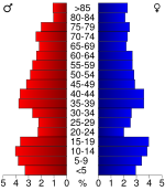
In the county the population was spread out with 26.20% under the age of 18, 7.00% from 18 to 24, 24.60% from 25 to 44, 22.10% from 45 to 64, and 20.00% who were 65 years of age or older. The median age was 40 years. For every 100 females there were 96.70 males. For every 100 females age 18 and over, there were 93.50 males.
The median income for a household
in the county was $33,244, and the median income for a family was $39,101. Males had a median income of $30,102 versus $20,705 for females. The per capita income
for the county was $16,458. About 10.60% of families and 12.80% of the population were below the poverty line, including 16.30% of those under age 18 and 11.00% of those age 65 or over.
. The city of Garnett
is considered governmentally independent and is excluded from the census figures for the townships. In the following table, the population center is the largest city (or cities) included in that township's population total, if it is of a significant size.
Historical
Maps
East-Central Kansas
East-Central Kansas is a region of Kansas. Extending roughly from Osage County, Franklin County, and Miami County in the north to Coffey County, Anderson County and Linn County in the south. The eastern border is Missouri. The region then extends westward towards the Flint Hills to Lyon County...
Kansas
Kansas
Kansas is a US state located in the Midwestern United States. It is named after the Kansas River which flows through it, which in turn was named after the Kansa Native American tribe, which inhabited the area. The tribe's name is often said to mean "people of the wind" or "people of the south...
, in the Central
Central United States
The Central United States is sometimes conceived as between the Eastern United States and Western United States as part of a three-region model, roughly coincident with the Midwestern United States plus the western and central portions of the Southern United States; the term is also sometimes used...
United States
United States
The United States of America is a federal constitutional republic comprising fifty states and a federal district...
. As of the 2010 census, the county population was 8,102. Its county seat
County seat
A county seat is an administrative center, or seat of government, for a county or civil parish. The term is primarily used in the United States....
and most populous city is Garnett
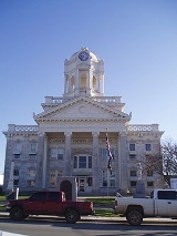
Garnett, Kansas
Garnett is a city in and the county seat of Anderson County, Kansas, United States. As of the 2010 census, the city population was 3,415.-Geography:Garnett is located at...
.
Law and government
Following amendment to the Kansas Constitution in 1986, the county remained a prohibition, or "dry"Dry county
A dry county is a county in the United States whose government forbids the sale of alcoholic beverages. Some prohibit off-premises sale, some prohibit on-premises sale, and some prohibit both. Hundreds of dry counties exist across the United States, almost all of them in the South...
, county until 1996, when voters approved the sale of alcoholic liquor by the individual drink with a 30% food sales requirement.
Geography
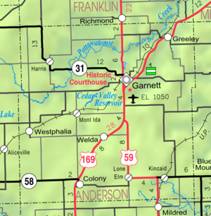
According to the 2000 census, the county has a total area of 584.29 square miles (1,513.3 km²), of which 582.92 square miles (1,509.8 km²) (or 99.77%) is land and 1.38 square miles (3.6 km²) (or 0.24%) is water.Adjacent counties
- Franklin CountyFranklin County, KansasFranklin County is a county located in East Central Kansas, in the Central United States. As of the 2010 census, the county population was 25,992. Its county seat and most populous city is Ottawa...
(north) - Miami CountyMiami County, KansasMiami County is a county located in East Central Kansas, in the Central United States. As of the 2010 census, the county population was 32,787. Its county seat and most populous city is Paola...
(northeast) - Linn CountyLinn County, KansasLinn County is a county located in East Central Kansas, in the Central United States. As of the 2010 census, the county population was 9,656. Its county seat is Mound City, and its most populous city is Pleasanton...
(east) - Bourbon CountyBourbon County, KansasBourbon County is a county located in Southeast Kansas, in the Central United States. As of the 2010 census, the county population was 15,173...
(southeast) - Allen CountyAllen County, KansasAllen County is a county located in southeast Kansas, in the central United States of America. As of the 2010 census, the county population was 13,371...
(south) - Woodson CountyWoodson County, KansasWoodson County is a county located in the U.S. state of Kansas. As of the 2010 census, the county population was 3,309...
(southwest) - Coffey CountyCoffey County, KansasCoffey County is a county located in East Central Kansas, in the Central United States. As of the 2010 census, the county population was 8,601...
(west)
Major highways
Sources: National Atlas, U.S. Census Bureau- U.S. Route 59U.S. Route 59U.S. Route 59 is a north–south United States highway . A latecomer to the U.S. numbered route system, U.S. 59 is now a border-to-border route, Part of NAFTA Corridor Highway System. It parallels U.S. Route 75 for nearly its entire route, never much more than away, until it veers southwest...
- U.S. Route 169U.S. Route 169U.S. Route 169 currently runs for 966 miles from the city of Virginia, Minnesota to Tulsa, Oklahoma at U.S. Route 64.-Oklahoma:U.S. Highway 169 is a major south–north highway spanning in Oklahoma. The southern terminus for US-169 is Memorial Drive...
- Kansas Highway 31
- Kansas Highway 52K-52 (Kansas highway)K-52 is a state highway in eastern Kansas. It is 22.4 mi long. K-52 begins concurrent with K-31 at U.S. Route 59 near Kincaid, and heads east toward Mound City, where it splits away from K-31. K-52 then overlaps U.S. Route 69 for through Pleasanton and Trading Post, where it splits off to...
- Kansas Highway 57
Demographics
United States Census, 2000
The Twenty-second United States Census, known as Census 2000 and conducted by the Census Bureau, determined the resident population of the United States on April 1, 2000, to be 281,421,906, an increase of 13.2% over the 248,709,873 persons enumerated during the 1990 Census...
, there were 8,110 people, 3,221 households, and 2,264 families residing in the county. The population density
Population density
Population density is a measurement of population per unit area or unit volume. It is frequently applied to living organisms, and particularly to humans...
was 14 people per square mile (5/km²). There were 3,596 housing units at an average density of 6 per square mile (2/km²). The racial makeup
Race (United States Census)
Race and ethnicity in the United States Census, as defined by the Federal Office of Management and Budget and the United States Census Bureau, are self-identification data items in which residents choose the race or races with which they most closely identify, and indicate whether or not they are...
of the county was 97.41% White
White American
White Americans are people of the United States who are considered or consider themselves White. The United States Census Bureau defines White people as those "having origins in any of the original peoples of Europe, the Middle East, or North Africa...
, 0.32% Black or African American
African American
African Americans are citizens or residents of the United States who have at least partial ancestry from any of the native populations of Sub-Saharan Africa and are the direct descendants of enslaved Africans within the boundaries of the present United States...
, 0.74% Native American
Native Americans in the United States
Native Americans in the United States are the indigenous peoples in North America within the boundaries of the present-day continental United States, parts of Alaska, and the island state of Hawaii. They are composed of numerous, distinct tribes, states, and ethnic groups, many of which survive as...
, 0.22% Asian
Asian American
Asian Americans are Americans of Asian descent. The U.S. Census Bureau definition of Asians as "Asian” refers to a person having origins in any of the original peoples of the Far East, Southeast Asia, or the Indian subcontinent, including, for example, Cambodia, China, India, Indonesia, Japan,...
, 0.02% Pacific Islander
Pacific Islander American
Pacific Islander Americans, also known as Oceanian Americans, are residents of the United States with original ancestry from Oceania. They represent the smallest racial group counted in the United States census of 2000. They numbered 874,000 people or 0.3 percent of the United States population...
, 0.33% from other races, and 0.95% from two or more races
Multiracial
The terms multiracial and mixed-race describe people whose ancestries come from multiple races. Unlike the term biracial, which often is only used to refer to having parents or grandparents of two different races, the term multiracial may encompass biracial people but can also include people with...
. Hispanic
Hispanic
Hispanic is a term that originally denoted a relationship to Hispania, which is to say the Iberian Peninsula: Andorra, Gibraltar, Portugal and Spain. During the Modern Era, Hispanic sometimes takes on a more limited meaning, particularly in the United States, where the term means a person of ...
or Latino
Latino
The demonyms Latino and Latina , are defined in English language dictionaries as:* "a person of Latin-American descent."* "A Latin American."* "A person of Hispanic, especially Latin-American, descent, often one living in the United States."...
of any race were 1.09% of the population. 35.0% were of German
Germans
The Germans are a Germanic ethnic group native to Central Europe. The English term Germans has referred to the German-speaking population of the Holy Roman Empire since the Late Middle Ages....
, 20.4% American
United States
The United States of America is a federal constitutional republic comprising fifty states and a federal district...
, 10.4% English
English people
The English are a nation and ethnic group native to England, who speak English. The English identity is of early mediaeval origin, when they were known in Old English as the Anglecynn. England is now a country of the United Kingdom, and the majority of English people in England are British Citizens...
and 9.9% Irish
Irish people
The Irish people are an ethnic group who originate in Ireland, an island in northwestern Europe. Ireland has been populated for around 9,000 years , with the Irish people's earliest ancestors recorded having legends of being descended from groups such as the Nemedians, Fomorians, Fir Bolg, Tuatha...
ancestry according to Census 2000.
There were 3,221 household
Household
The household is "the basic residential unit in which economic production, consumption, inheritance, child rearing, and shelter are organized and carried out"; [the household] "may or may not be synonymous with family"....
s out of which 31.00% had children under the age of 18 living with them, 59.90% were married couples
Marriage
Marriage is a social union or legal contract between people that creates kinship. It is an institution in which interpersonal relationships, usually intimate and sexual, are acknowledged in a variety of ways, depending on the culture or subculture in which it is found...
living together, 6.90% had a female householder with no husband present, and 29.70% were non-families. 26.80% of all households were made up of individuals and 15.60% had someone living alone who was 65 years of age or older. The average household size was 2.48 and the average family size was 3.00.
In the county the population was spread out with 26.20% under the age of 18, 7.00% from 18 to 24, 24.60% from 25 to 44, 22.10% from 45 to 64, and 20.00% who were 65 years of age or older. The median age was 40 years. For every 100 females there were 96.70 males. For every 100 females age 18 and over, there were 93.50 males.
The median income for a household
Median household income
The median household income is commonly used to generate data about geographic areas and divides households into two equal segments with the first half of households earning less than the median household income and the other half earning more...
in the county was $33,244, and the median income for a family was $39,101. Males had a median income of $30,102 versus $20,705 for females. The per capita income
Per capita income
Per capita income or income per person is a measure of mean income within an economic aggregate, such as a country or city. It is calculated by taking a measure of all sources of income in the aggregate and dividing it by the total population...
for the county was $16,458. About 10.60% of families and 12.80% of the population were below the poverty line, including 16.30% of those under age 18 and 11.00% of those age 65 or over.
Incorporated cities
Name and population ( estimate):- GarnettGarnett, KansasGarnett is a city in and the county seat of Anderson County, Kansas, United States. As of the 2010 census, the city population was 3,415.-Geography:Garnett is located at...
, (county seat) - ColonyColony, KansasColony is a city in Anderson County, Kansas, United States. As of the 2010 census, the city population was 408.-Geography:Colony is located at . According to the United States Census Bureau, the city has a total area of , all of it land.-Demographics:As of the census of 2000, there were 397...
, - GreeleyGreeley, KansasGreeley is a city in Anderson County, Kansas, United States. As of the 2010 census, the city population was 302.-Geography:Greeley is located at . According to the United States Census Bureau, the city has a total area of , all of it land.-Demographics:As of the census of 2000, there were 327...
, - KincaidKincaid, KansasKincaid is a city in Anderson County, Kansas, United States. As of the 2010 census, the city population was 122.-Geography:Kincaid is located at...
, - WestphaliaWestphalia, KansasWestphalia is a city in Anderson County, Kansas, United States. As of the 2010 census, the city population was 163.-Geography:Westphalia is located at...
, - HarrisHarris, KansasHarris is a city in Anderson County, Kansas, United States. As of the 2010 census, the city population was 51.-Geography:Harris is located at . According to the United States Census Bureau, the city has a total area of , all of it land.-Demographics:As of the census of 2000, there were 53 people,...
, 53 (from Census 2000) - Lone ElmLone Elm, KansasLone Elm is a city in Anderson County, Kansas, United States. As of the 2010 census, the city population was 25.-Geography:Lone Elm is located at . According to the United States Census Bureau, the city has a total area of , all land....
,
Unincorporated places
- Amiot
- Bush City
- Central City
- Glenloch (Glenlock)
- Mont Ida
- Northcott
- Scipio
- Selma
- Welda
Townships
Anderson County is divided into fourteen townshipsCivil township
A civil township is a widely used unit of local government in the United States, subordinate to, and geographic divisions of, a county. Specific responsibilities and the degree of autonomy vary based on each state. Civil townships are distinct from survey townships, but in states that have both,...
. The city of Garnett
Garnett, Kansas
Garnett is a city in and the county seat of Anderson County, Kansas, United States. As of the 2010 census, the city population was 3,415.-Geography:Garnett is located at...
is considered governmentally independent and is excluded from the census figures for the townships. In the following table, the population center is the largest city (or cities) included in that township's population total, if it is of a significant size.
| Township | FIPS | Population center |
Population | Population density /km² (/sq mi) |
Land area km² (sq mi) | Water area km² (sq mi) | Water % | Geographic coordinates |
|---|---|---|---|---|---|---|---|---|
| Indian Creek | 34050 | 132 | 1 (3) | 125 (48) | 0 (0) | 0.07% | 38°5′21"N 95°27′33"W | |
| Jackson | 34725 | 453 | 5 (13) | 88 (34) | 0 (0) | 0.06% | 38°17′44"N 95°17′48"W | |
| Lincoln | 40475 | 208 | 2 (4) | 128 (49) | 0 (0) | 0.22% | 38°12′42"N 95°8′42"W | |
| Lone Elm | 42450 | 239 | 2 (5) | 120 (46) | 0 (0) | 0.21% | 38°4′56"N 95°14′30"W | |
| Monroe | 47725 | 349 | 5 (12) | 74 (29) | 0 (0) | 0.11% | 38°17′44"N 95°12′54"W | |
| North Rich | 51325 | 112 | 2 (5) | 62 (24) | 0 (0) | 0.06% | 38°8′10"N 95°7′24"W | |
| Ozark | 53900 | Colony Colony, Kansas Colony is a city in Anderson County, Kansas, United States. As of the 2010 census, the city population was 408.-Geography:Colony is located at . According to the United States Census Bureau, the city has a total area of , all of it land.-Demographics:As of the census of 2000, there were 397... |
565 | 6 (16) | 93 (36) | 0 (0) | 0.07% | 38°4′24"N 95°21′37"W |
| Putnam | 58000 | 284 | 3 (8) | 87 (34) | 0 (0) | 0.11% | 38°21′41"N 95°16′4"W | |
| Reeder | 58825 | 427 | 2 (6) | 187 (72) | 1 (0) | 0.44% | 38°19′14"N 95°26′6"W | |
| Rich | 59175 | Kincaid Kincaid, Kansas Kincaid is a city in Anderson County, Kansas, United States. As of the 2010 census, the city population was 122.-Geography:Kincaid is located at... |
346 | 4 (11) | 78 (30) | 0 (0) | 0.21% | 38°4′48"N 95°8′58"W |
| Walker | 74650 | Greeley Greeley, Kansas Greeley is a city in Anderson County, Kansas, United States. As of the 2010 census, the city population was 302.-Geography:Greeley is located at . According to the United States Census Bureau, the city has a total area of , all of it land.-Demographics:As of the census of 2000, there were 327... |
668 | 6 (15) | 117 (45) | 0 (0) | 0.38% | 38°21′4"N 95°6′47"W |
| Washington | 75500 | 268 | 3 (7) | 93 (36) | 0 (0) | 0.19% | 38°13′47"N 95°17′5"W | |
| Welda | 76450 | 301 | 3 (7) | 116 (45) | 0 (0) | 0.22% | 38°9′44"N 95°19′17"W | |
| Westphalia | 77275 | Westphalia Westphalia, Kansas Westphalia is a city in Anderson County, Kansas, United States. As of the 2010 census, the city population was 163.-Geography:Westphalia is located at... |
390 | 3 (8) | 134 (52) | 1 (0) | 0.38% | 38°11′56"N 95°27′46"W |
| Sources: | ||||||||
Unified school districts
- Garnett USD 365
- Anderson County High School
- Crest USD 479
- Crest High SchoolCrest High SchoolCrest High School is a fully accredited public high school located in Colony, Kansas, serving students in grades 9-12. The school colors are red and blue and the school mascot is the Lancer. Crest High serves approximately 100 students per year...
- Crest High School
See also
- National Register of Historic Places listings in Anderson County, Kansas
Further reading
- History of the State of Kansas; William G. Cutler; A.T. Andreas Publisher; 1883. (Online HTML eBook)
- Kansas : A Cyclopedia of State History, Embracing Events, Institutions, Industries, Counties, Cities, Towns, Prominent Persons, Etc; 3 Volumes; Frank W. Blackmar; Standard Publishing Co; 944 / 955 / 824 pages; 1912. (Volume1 - Download 54MB PDF eBook), (Volume2 - Download 53MB PDF eBook), (Volume3 - Download 33MB PDF eBook)
External links
County- Anderson County - Official Website
- Anderson County - Directory of Public Officials
- Anderson County - Development Agency
- Anderson County - Information, Skyways
Historical
- Anderson County - History, Kansas State Historical Society
Maps
- Anderson County Map, KDOT
- Kansas Highway Map, KDOT
- Kansas Railroad Map, KDOT
- Kansas School District Boundary Map, KSDE