
Metropolitan Borough of St Helens
Encyclopedia
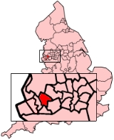
The Metropolitan Borough of St Helens is a metropolitan borough
of Merseyside
, in North West
England
. It is named after its largest town St Helens
, and covers an area which includes the settlements of Newton-le-Willows
, Earlestown
, Haydock
, Rainhill
, Eccleston, Clock Face
, Billinge and Rainford
.
Ward profiles are maintained by the Metropolitan Borough Council.
of St Helens
, along with the urban district
s of Haydock
, Newton-le-Willows
and Rainford
, and parts of Billinge-and-Winstanley
and Ashton-in-Makerfield
urban districts, along with part of Whiston Rural District
, all from the administrative county
of Lancashire
.
Between 1974 and 1986 the borough council shared functions with Merseyside County Council. The functions of this body were in part devolved to the boroughs and in part transferred to ad hoc agencies.
held on 4 May, the political control of the Council changed from the Labour Party to a coalition formed by the Liberal Democrats and the Conservative Party. Labour had been in power since 1 April 1974 following the first elections to the shadow council in 1973.
After local elections in 2008
St Helens was a hung council
with no party having overall control, as a result The Liberal Democrats and the Conservative coalition continued their governance of the council. Labour were the largest party represented followed by the Liberal Democrats and then the Conservatives.
After local elections in 2010
the Labour Party retook overall control of St Helens council with a majority of 8 after increasing its tally by 5 at the expense of the Liberal Democrats and the Conservatives. This brought to an end the Lib/Con coalition which had governed the council since 2006. Labour continue to be the largest party represented followed by the Liberal Democrats and then the Conservatives.
Following the United Kingdom local elections, 2011
, in which one third of the seats in St Helens Council were up for election, Labour increased their majority by 7, as a result of the collapse of the Liberal Democrat vote, with them losing all but one of the seats they were defending while the Conservatives also lost one seat to Labour.
 The borough borders the borough of Knowsley
, within Merseyside, in the south-west, the Lancashire district of West Lancashire
in the north, the Greater Manchester
Borough of Wigan
in the north-east, and to the south the boroughs of Warrington
and Halton
in Cheshire
.
The St Helens Borough covers roughly 30 km² over an area of soft rolling hills used primarily for agricultural purposes, mainly arable
. The highest point in the Metropolitan Borough of St Helens, and the whole of Merseyside is Billinge Hill
, 4.5 miles (7.2 km) north from the town centre. The town is landlocked with a stream running through, Mill Brook/Windle Brook running through Eccleston and connecting with the (disused) St. Helens Branch/Section of the Sankey Canal
in the town centre. St Helens is around 160 feet (50 m) above sea level.
From the top of Billinge Hill the cities of Manchester
and Liverpool
are visible on a clear day as well as the towns of Wigan
, Bolton
and Warrington
.
Carr Mill Dam
is Merseyside's largest body of inland water, offering picturesque lakeside trails and walks as well as national competitive powerboating and angling events.
The Burgies
are two tailings
on the site of the old Rushy Park coal mine. They were created by the dumping of toxic chemical waste from the manufacture of glass, they have since been covered with tall grass and woodland.
Metropolitan borough
A metropolitan borough is a type of local government district in England, and is a subdivision of a metropolitan county. Created in 1974 by the Local Government Act 1972, metropolitan boroughs are defined in English law as metropolitan districts, however all of them have been granted or regranted...
of Merseyside
Merseyside
Merseyside is a metropolitan county in North West England, with a population of 1,365,900. It encompasses the metropolitan area centred on both banks of the lower reaches of the Mersey Estuary, and comprises five metropolitan boroughs: Knowsley, St Helens, Sefton, Wirral, and the city of Liverpool...
, in North West
North West England
North West England, informally known as The North West, is one of the nine official regions of England.North West England had a 2006 estimated population of 6,853,201 the third most populated region after London and the South East...
England
England
England is a country that is part of the United Kingdom. It shares land borders with Scotland to the north and Wales to the west; the Irish Sea is to the north west, the Celtic Sea to the south west, with the North Sea to the east and the English Channel to the south separating it from continental...
. It is named after its largest town St Helens
St Helens, Merseyside
St Helens is a large town in Merseyside, England. It is the largest settlement and administrative centre of the Metropolitan Borough of St Helens with a population of just over 100,000, part of an urban area with a total population of 176,843 at the time of the 2001 Census...
, and covers an area which includes the settlements of Newton-le-Willows
Newton-le-Willows
Newton-le-Willows is a small market town within the Metropolitan Borough of St Helens, in Merseyside, England. Historically a part of Lancashire, it is situated about midway between the cities of Manchester and Liverpool, to the east of St Helens, to the north of Warrington and to the south of...
, Earlestown
Earlestown
Earlestown forms the western part of Newton-le-Willows, a town in the Metropolitan Borough of St Helens, in Merseyside, England. At the 2001 Census the population was recorded as 10,274.-History:...
, Haydock
Haydock
Haydock is a village within the Metropolitan Borough of St Helens, in Merseyside, England. It contains all of the Haydock electoral ward and a section of the Blackbrook electoral ward. The village is located roughly mid-way between Liverpool and Manchester, close to the junction of the M6 motorway...
, Rainhill
Rainhill
Rainhill is a large village and civil parish of the Metropolitan Borough of St Helens, in Merseyside, England.Historically a part of Lancashire, Rainhill was formerly a township within the ecclesiastical parish of Prescot, and hundred of West Derby...
, Eccleston, Clock Face
Clock Face, Merseyside
Clock Face is an area of St. Helens, Merseyside, England, south of the town centre, situated near Sutton Manor in the district of Sutton, and just north of the M62 motorway. Historically a part of Lancashire, Clock Face forms part of the parish of Bold. It is also a ward within the Metropolitan...
, Billinge and Rainford
Rainford
Rainford is a village and civil parish within Metropolitan Borough of St Helens, in Merseyside, England. It is around north of St Helens. At the 2001 Census the population of the civil parish was 8,344....
.
Ward profiles are maintained by the Metropolitan Borough Council.
History
The Metropolitan Borough was formed on 1 April 1974 as a merger of the former County BoroughCounty borough
County borough is a term introduced in 1889 in the United Kingdom of Great Britain and Ireland , to refer to a borough or a city independent of county council control. They were abolished by the Local Government Act 1972 in England and Wales, but continue in use for lieutenancy and shrievalty in...
of St Helens
St Helens, Merseyside
St Helens is a large town in Merseyside, England. It is the largest settlement and administrative centre of the Metropolitan Borough of St Helens with a population of just over 100,000, part of an urban area with a total population of 176,843 at the time of the 2001 Census...
, along with the urban district
Urban district
In the England, Wales and Ireland, an urban district was a type of local government district that covered an urbanised area. Urban districts had an elected Urban District Council , which shared local government responsibilities with a county council....
s of Haydock
Haydock
Haydock is a village within the Metropolitan Borough of St Helens, in Merseyside, England. It contains all of the Haydock electoral ward and a section of the Blackbrook electoral ward. The village is located roughly mid-way between Liverpool and Manchester, close to the junction of the M6 motorway...
, Newton-le-Willows
Newton-le-Willows
Newton-le-Willows is a small market town within the Metropolitan Borough of St Helens, in Merseyside, England. Historically a part of Lancashire, it is situated about midway between the cities of Manchester and Liverpool, to the east of St Helens, to the north of Warrington and to the south of...
and Rainford
Rainford
Rainford is a village and civil parish within Metropolitan Borough of St Helens, in Merseyside, England. It is around north of St Helens. At the 2001 Census the population of the civil parish was 8,344....
, and parts of Billinge-and-Winstanley
Billinge and Winstanley Urban District
Billinge was, from 1894 to 1974, a local government district in the administrative county of Lancashire, England....
and Ashton-in-Makerfield
Ashton-in-Makerfield
Ashton-in-Makerfield is a town in the Metropolitan Borough of Wigan, Greater Manchester. It is situated south of Wigan, north-northwest of Warrington and west of the city of Manchester. In 2001 it had a population of 28,505....
urban districts, along with part of Whiston Rural District
Whiston Rural District
Whiston Rural District was a rural district of the administrative county of Lancashire, England. It was created in 1895 by renaming the Prescot Rural District when the parish of Prescot was removed from that rural district and created a separate urban district. Later the parish of Speke was...
, all from the administrative county
Administrative counties of England
Administrative counties were a level of subnational division of England used for the purposes of local government from 1889 to 1974. They were created by the Local Government Act 1888 as the areas for which county councils were elected. Some large counties were divided into several administrative...
of Lancashire
Lancashire
Lancashire is a non-metropolitan county of historic origin in the North West of England. It takes its name from the city of Lancaster, and is sometimes known as the County of Lancaster. Although Lancaster is still considered to be the county town, Lancashire County Council is based in Preston...
.
Between 1974 and 1986 the borough council shared functions with Merseyside County Council. The functions of this body were in part devolved to the boroughs and in part transferred to ad hoc agencies.
Governance
On 17 May 2006, following local electionsSt Helens Council election 2006
Elections to St Helens Council were held on 4th May, 2006. One third of the council was up for election and the council stayed under no overall control.After the election, the composition of the council was*Labour 23*Liberal Democrat 19*Conservative 6...
held on 4 May, the political control of the Council changed from the Labour Party to a coalition formed by the Liberal Democrats and the Conservative Party. Labour had been in power since 1 April 1974 following the first elections to the shadow council in 1973.
After local elections in 2008
United Kingdom local elections, 2008
The 2008 United Kingdom local elections were held on 1 May 2008. These elections took place in 137 English Local Authorities and all Welsh Councils....
St Helens was a hung council
No overall control
Within the context of local councils of the United Kingdom, the term No Overall Control refers to a situation in which no single party achieves a majority of seats and is analogous to a hung parliament...
with no party having overall control, as a result The Liberal Democrats and the Conservative coalition continued their governance of the council. Labour were the largest party represented followed by the Liberal Democrats and then the Conservatives.
| Year | Labour Labour Party (UK) The Labour Party is a centre-left democratic socialist party in the United Kingdom. It surpassed the Liberal Party in general elections during the early 1920s, forming minority governments under Ramsay MacDonald in 1924 and 1929-1931. The party was in a wartime coalition from 1940 to 1945, after... | Liberal Democrats Liberal Democrats The Liberal Democrats are a social liberal political party in the United Kingdom which supports constitutional and electoral reform, progressive taxation, wealth taxation, human rights laws, cultural liberalism, banking reform and civil liberties .The party was formed in 1988 by a merger of the... | Conservatives Conservative Party (UK) The Conservative Party, formally the Conservative and Unionist Party, is a centre-right political party in the United Kingdom that adheres to the philosophies of conservatism and British unionism. It is the largest political party in the UK, and is currently the largest single party in the House... |
|---|---|---|---|
| 2008 | 23 | 19 | 6 |
After local elections in 2010
United Kingdom local elections, 2010
The 2010 United Kingdom local elections were held on Thursday 6 May 2010, when the 2010 general election also took place. Direct elections were held to all 32 London boroughs, all 36 metropolitan boroughs, 76 second-tier district authorities, 20 unitary authorities and various Mayoral posts, all in...
the Labour Party retook overall control of St Helens council with a majority of 8 after increasing its tally by 5 at the expense of the Liberal Democrats and the Conservatives. This brought to an end the Lib/Con coalition which had governed the council since 2006. Labour continue to be the largest party represented followed by the Liberal Democrats and then the Conservatives.
| Year | Labour Labour Party (UK) The Labour Party is a centre-left democratic socialist party in the United Kingdom. It surpassed the Liberal Party in general elections during the early 1920s, forming minority governments under Ramsay MacDonald in 1924 and 1929-1931. The party was in a wartime coalition from 1940 to 1945, after... | Liberal Democrats Liberal Democrats The Liberal Democrats are a social liberal political party in the United Kingdom which supports constitutional and electoral reform, progressive taxation, wealth taxation, human rights laws, cultural liberalism, banking reform and civil liberties .The party was formed in 1988 by a merger of the... | Conservatives Conservative Party (UK) The Conservative Party, formally the Conservative and Unionist Party, is a centre-right political party in the United Kingdom that adheres to the philosophies of conservatism and British unionism. It is the largest political party in the UK, and is currently the largest single party in the House... |
|---|---|---|---|
| 2010 | 28 | 15 | 5 |
Following the United Kingdom local elections, 2011
United Kingdom local elections, 2011
The 2011 United Kingdom local elections were held on Thursday 5 May 2011. In England, direct elections were held in all 36 Metropolitan boroughs, 194 Second-tier district authorities, 49 unitary authorities and various mayoral posts, meaning local elections took place in all parts of England with...
, in which one third of the seats in St Helens Council were up for election, Labour increased their majority by 7, as a result of the collapse of the Liberal Democrat vote, with them losing all but one of the seats they were defending while the Conservatives also lost one seat to Labour.
| Year | Labour Labour Party (UK) The Labour Party is a centre-left democratic socialist party in the United Kingdom. It surpassed the Liberal Party in general elections during the early 1920s, forming minority governments under Ramsay MacDonald in 1924 and 1929-1931. The party was in a wartime coalition from 1940 to 1945, after... | Liberal Democrats Liberal Democrats The Liberal Democrats are a social liberal political party in the United Kingdom which supports constitutional and electoral reform, progressive taxation, wealth taxation, human rights laws, cultural liberalism, banking reform and civil liberties .The party was formed in 1988 by a merger of the... | Conservatives Conservative Party (UK) The Conservative Party, formally the Conservative and Unionist Party, is a centre-right political party in the United Kingdom that adheres to the philosophies of conservatism and British unionism. It is the largest political party in the UK, and is currently the largest single party in the House... |
|---|---|---|---|
| 2011 | 35 | 9 | 4 |
Parliamentary constituencies
- St Helens NorthSt Helens North (UK Parliament constituency)St. Helens North is a borough constituency represented in the House of Commons of the Parliament of the United Kingdom. It elects one Member of Parliament by the first past the post system of election.-Boundaries:...
- St Helens South and WhistonSt Helens South and Whiston (UK Parliament constituency)St. Helens South and Whiston is a borough constituency represented in the House of Commons of the Parliament of the United Kingdom. It elects one Member of Parliament by the first past the post system of election.-Boundaries:...
Geography
Metropolitan Borough of Knowsley
The Metropolitan Borough of Knowsley is a metropolitan borough of Merseyside, England. It comprises the towns of Kirkby, Prescot, Huyton, Whiston, Halewood and Cronton; Kirkby, Huyton, and Prescot being the major commercial centres...
, within Merseyside, in the south-west, the Lancashire district of West Lancashire
West Lancashire
West Lancashire is a non-metropolitan district with the status of a borough in Lancashire, England. Its council is based in Ormskirk. The other town in the borough is Skelmersdale....
in the north, the Greater Manchester
Greater Manchester
Greater Manchester is a metropolitan county in North West England, with a population of 2.6 million. It encompasses one of the largest metropolitan areas in the United Kingdom and comprises ten metropolitan boroughs: Bolton, Bury, Oldham, Rochdale, Stockport, Tameside, Trafford, Wigan, and the...
Borough of Wigan
Metropolitan Borough of Wigan
The Metropolitan Borough of Wigan is a metropolitan borough of Greater Manchester, in North West England. It is named after its largest component town, Wigan and also includes the towns of Leigh, Ashton-in-Makerfield, Ince-in-Makerfield, and Hindley. The borough was formed in 1974 and is an...
in the north-east, and to the south the boroughs of Warrington
Warrington
Warrington is a town, borough and unitary authority area of Cheshire, England. It stands on the banks of the River Mersey, which is tidal to the west of the weir at Howley. It lies 16 miles east of Liverpool, 19 miles west of Manchester and 8 miles south of St Helens...
and Halton
Halton (borough)
Halton is a local government district in North West England, with borough status and administered by a unitary authority. It was created in 1974 as a district of Cheshire, and became a unitary authority area on 1 April 1998. It consists of the towns of Widnes and Runcorn and the civil parishes of...
in Cheshire
Cheshire
Cheshire is a ceremonial county in North West England. Cheshire's county town is the city of Chester, although its largest town is Warrington. Other major towns include Widnes, Congleton, Crewe, Ellesmere Port, Runcorn, Macclesfield, Winsford, Northwich, and Wilmslow...
.
The St Helens Borough covers roughly 30 km² over an area of soft rolling hills used primarily for agricultural purposes, mainly arable
Arable land
In geography and agriculture, arable land is land that can be used for growing crops. It includes all land under temporary crops , temporary meadows for mowing or pasture, land under market and kitchen gardens and land temporarily fallow...
. The highest point in the Metropolitan Borough of St Helens, and the whole of Merseyside is Billinge Hill
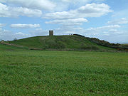
Billinge Hill
Billinge Hill, also known as Billinge Lump, is the highest point in the Metropolitan Borough of St Helens in North West England. It is also the highest point of Merseyside It lies in Billinge, within the historic county boundaries of Lancashire....
, 4.5 miles (7.2 km) north from the town centre. The town is landlocked with a stream running through, Mill Brook/Windle Brook running through Eccleston and connecting with the (disused) St. Helens Branch/Section of the Sankey Canal
Sankey Canal
The Sankey Canal, which is also known as the Sankey Brook Navigation and the St Helens Canal, is a canal in Cheshire, extending into Merseyside, in the northwest of England, connecting St Helens with the River Mersey...
in the town centre. St Helens is around 160 feet (50 m) above sea level.
From the top of Billinge Hill the cities of Manchester
Manchester
Manchester is a city and metropolitan borough in Greater Manchester, England. According to the Office for National Statistics, the 2010 mid-year population estimate for Manchester was 498,800. Manchester lies within one of the UK's largest metropolitan areas, the metropolitan county of Greater...
and Liverpool
Liverpool
Liverpool is a city and metropolitan borough of Merseyside, England, along the eastern side of the Mersey Estuary. It was founded as a borough in 1207 and was granted city status in 1880...
are visible on a clear day as well as the towns of Wigan
Wigan
Wigan is a town in Greater Manchester, England. It stands on the River Douglas, south-west of Bolton, north of Warrington and west-northwest of Manchester. Wigan is the largest settlement in the Metropolitan Borough of Wigan and is its administrative centre. The town of Wigan had a total...
, Bolton
Bolton
Bolton is a town in Greater Manchester, in the North West of England. Close to the West Pennine Moors, it is north west of the city of Manchester. Bolton is surrounded by several smaller towns and villages which together form the Metropolitan Borough of Bolton, of which Bolton is the...
and Warrington
Warrington
Warrington is a town, borough and unitary authority area of Cheshire, England. It stands on the banks of the River Mersey, which is tidal to the west of the weir at Howley. It lies 16 miles east of Liverpool, 19 miles west of Manchester and 8 miles south of St Helens...
.
Carr Mill Dam
Carr Mill Dam
Carr Mill Dam is situated north of St Helens town centre, on the A571 , in Merseyside. It is the county's largest body of inland water, and offers picturesque lakeside trails and walks, as well as national competitive powerboating and angling events.Once simply a mill pond built to power Carr’s...
is Merseyside's largest body of inland water, offering picturesque lakeside trails and walks as well as national competitive powerboating and angling events.
The Burgies
The Burgies
The Burgies are a set of two slag heaps located in the Islands Brow area of St Helens. The two are divided by Islands Brow road and are bordered on the west side by the rail line connecting Liverpool Lime Street with Wigan North Western...
are two tailings
Tailings
Tailings, also called mine dumps, slimes, tails, leach residue, or slickens, are the materials left over after the process of separating the valuable fraction from the uneconomic fraction of an ore...
on the site of the old Rushy Park coal mine. They were created by the dumping of toxic chemical waste from the manufacture of glass, they have since been covered with tall grass and woodland.
Demography
| St Helens Population using 2001 Data, 2008 Wards | ||
|---|---|---|
| 2001 UK Census United Kingdom Census 2001 A nationwide census, known as Census 2001, was conducted in the United Kingdom on Sunday, 29 April 2001. This was the 20th UK Census and recorded a resident population of 58,789,194.... |
Population | Households |
| Billinge and Seneley Green | 12,717 | 4985 |
| Blackbrook | 9,128 | 3,604 |
| Bold | 9,040 | 3,586 |
| Earlestown | 10,274 | 4,420 |
| Eccleston | 10,528 | 4,218 |
| Haydock | 11,962 | 4,817 |
| Moss Bank | 10,276 | 4,337 |
| Newton | 11,144 | 4,506 |
| Parr | 12,082 | 3,541 |
| Rainford Rainford Rainford is a village and civil parish within Metropolitan Borough of St Helens, in Merseyside, England. It is around north of St Helens. At the 2001 Census the population of the civil parish was 8,344.... |
8344 | 3,484 |
| Rainhill | 11,913 | 4,762 |
| Sutton | 12,622 | 5,075 |
| Thatto Heath | 9,393 | 3,852 |
| Town Centre | 10,795 | 4,958 |
| West Park | 11,558 | 4,947 |
| Windle | 8,621 | 3,607 |
| Total | 176,843 | 72,697 |