
Methana
Encyclopedia
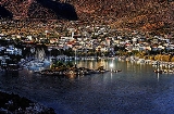
Methana is a town and a former municipality
on the Peloponnese
peninsula, Greece
. Since the 2011 local government reform it is part of the municipality Troizinia
, of which it is a municipal unit.
Methana is situated on a volcanic
(the Methana Volcano
) peninsula
, attached to the Peloponnese. Administratively, it belongs to the Attica region. The town (pop. 1,148 in 2001) is located north of the road connecting to the rest of the Peloponnese and Galatas. The highest point is 740 m (Helona Mountain). The municipal unit has a land area of 50.161 km² and a 2001 census population of 2,057 inhabitants. Its largest other settlements besides the town of Methana are Vathý (pop. 170), Megalochóri (167), Kounoupítsa (136), Kypséli (94), Ágioi Theódoroi (75), and Dritsaíika (64).
Half of the entire peninsula's population lives in Methana town.
origin and contains over 30 volcanic eruption centers. The last volcanic eruption occurred near present-day Kameni Chora
in 230 BC and a submarine volcano erupted in 1700. Famous writers such as Ovid
, Strabo
and Pausanias
reported the last volcanic eruption in Methana. The peninsula is the northwesternmost of the arc of the Aegean
islands of which the active volcanic areas are Methana, Milos
, Santorini
and Nisyros
. In the future, Methana (and the area of the Saronic gulf
) may expect other volcanic eruptions.
 Since 1991, the peninsula has been investigated by the team of ETH Zürich
geologically and cartographically. From this, a topographical map of the entire peninsula at a scale of 1:25,000 was made. An interactive 3D map was created and is on the World Wide Web. Also a rich photographic archive with about 10.000 color slides has been produced (see links below).
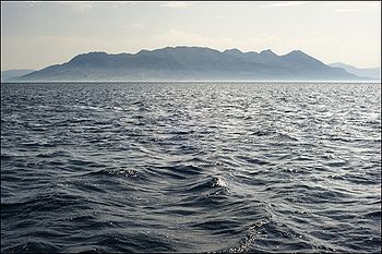
The panorama of the northeastern part of Argolis
, southeastern and eastern Corinthia
along with the southern part of the Attica
peninsula and the Saronic Islands
of Aegina
and Salamis
along with a smaller one and the mountains of the eastern tip of the neighboring peninsula.
Much of the peninsula is mountainous and bushy and grassy. The mountain range covers the central part of the peninsula and has a small ridge north of the seat. The residential area is within the sea. The pastures are around Methana. A mountain ridge is founded in the west and is about 3 km long with a stream in the middle and a cliff in the south.
is located near the village of Vathy. The fortress is in Kypseli
at the coast Akropolis Oga at the principal pace of Nisaki
(Νησάκι, meaning little island). A Mycenaean
settlement was excavated by Helene Konstolakis-Jiannopoulou in 1990 along with the chapel of Agios Konstantinos and Elenis. Selected artifacts can be visited in the museums of Poros island and in Piraeus. This site dates between 1500 and 1300 BC. In his History of the Peloponnesian War
, Thucydides
tells of an Athenian expeditionary force under Nicias
that after defeating Corinth (in 425 BC) built a wall across the isthmus to cut the Methana peninsula off from the mainland. In the Hellenistic period, the peninsula became one of the Ptolemaic bases in the Aegean when it was renamed Arsinoe. Traditionally, the population of Methana were Arvanites
.
Communities and Municipalities of Greece
For the new municipalities of Greece see the Kallikratis ProgrammeThe municipalities and communities of Greece are one of several levels of government within the organizational structure of that country. Thirteen regions called peripheries form the largest unit of government beneath the State. ...
on the Peloponnese
Peloponnese
The Peloponnese, Peloponnesos or Peloponnesus , is a large peninsula , located in a region of southern Greece, forming the part of the country south of the Gulf of Corinth...
peninsula, Greece
Greece
Greece , officially the Hellenic Republic , and historically Hellas or the Republic of Greece in English, is a country in southeastern Europe....
. Since the 2011 local government reform it is part of the municipality Troizinia
Troizinia
Troizinia is a municipality in the Islands regional unit, Attica, Greece. The seat of the municipality is the town Galatas.-Municipality:The municipality Troizinia was formed at the 2011 local government reform by the merger of the following 2 former municipalities, that became municipal units...
, of which it is a municipal unit.
Methana is situated on a volcanic
Volcano
2. Bedrock3. Conduit 4. Base5. Sill6. Dike7. Layers of ash emitted by the volcano8. Flank| 9. Layers of lava emitted by the volcano10. Throat11. Parasitic cone12. Lava flow13. Vent14. Crater15...
(the Methana Volcano
Methana Volcano
The Methana volcano peninsula is situated approximately 50 km southeast of Athens in Greece.-Geological history:The Methana peninsula contains some 32 volcanoes, that are mostly andesitic / dacitic lava domes.The volcanic activity in the peninsula began one million years ago and continued...
) peninsula
Peninsula
A peninsula is a piece of land that is bordered by water on three sides but connected to mainland. In many Germanic and Celtic languages and also in Baltic, Slavic and Hungarian, peninsulas are called "half-islands"....
, attached to the Peloponnese. Administratively, it belongs to the Attica region. The town (pop. 1,148 in 2001) is located north of the road connecting to the rest of the Peloponnese and Galatas. The highest point is 740 m (Helona Mountain). The municipal unit has a land area of 50.161 km² and a 2001 census population of 2,057 inhabitants. Its largest other settlements besides the town of Methana are Vathý (pop. 170), Megalochóri (167), Kounoupítsa (136), Kypséli (94), Ágioi Theódoroi (75), and Dritsaíika (64).
Subdivisions
The municipal unit Methana is subdivided into the following communities (constituent villages in brackets):- Kounoupitsa (Kounoupitsa, Agios Georgios, Agios Nikolaos, Makrylongos, Palia Loutra)
- Kypseli (Kypseli, Agioi Theodoroi)
- Loutropoli Methanon (Methana, Dritsaiika)
- Megalochori (Megalochori, Vathy, Kaimeni Chora, Megalo Potami)
Historical population
| Year | Town population | Municipality population |
|---|---|---|
| 1981 | 1,035 | - |
| 1991 | 1,054 | 2,056 |
| 2001 | 1,148 | 2,057 |
Half of the entire peninsula's population lives in Methana town.
Volcanic activity
The peninsula is entirely of volcanicVolcano
2. Bedrock3. Conduit 4. Base5. Sill6. Dike7. Layers of ash emitted by the volcano8. Flank| 9. Layers of lava emitted by the volcano10. Throat11. Parasitic cone12. Lava flow13. Vent14. Crater15...
origin and contains over 30 volcanic eruption centers. The last volcanic eruption occurred near present-day Kameni Chora
Kameni Chora
Kameni Chora is a village located in the northwestern part of the Methana peninsula. It is located in a valley northwest of the volcanic summit...
in 230 BC and a submarine volcano erupted in 1700. Famous writers such as Ovid
Ovid
Publius Ovidius Naso , known as Ovid in the English-speaking world, was a Roman poet who is best known as the author of the three major collections of erotic poetry: Heroides, Amores, and Ars Amatoria...
, Strabo
Strabo
Strabo, also written Strabon was a Greek historian, geographer and philosopher.-Life:Strabo was born to an affluent family from Amaseia in Pontus , a city which he said was situated the approximate equivalent of 75 km from the Black Sea...
and Pausanias
Pausanias (geographer)
Pausanias was a Greek traveler and geographer of the 2nd century AD, who lived in the times of Hadrian, Antoninus Pius and Marcus Aurelius. He is famous for his Description of Greece , a lengthy work that describes ancient Greece from firsthand observations, and is a crucial link between classical...
reported the last volcanic eruption in Methana. The peninsula is the northwesternmost of the arc of the Aegean
Aegean Sea
The Aegean Sea[p] is an elongated embayment of the Mediterranean Sea located between the southern Balkan and Anatolian peninsulas, i.e., between the mainlands of Greece and Turkey. In the north, it is connected to the Marmara Sea and Black Sea by the Dardanelles and Bosporus...
islands of which the active volcanic areas are Methana, Milos
Milos
Milos , is a volcanic Greek island in the Aegean Sea, just north of the Sea of Crete...
, Santorini
Santorini
Santorini , officially Thira , is an island located in the southern Aegean Sea, about southeast from Greece's mainland. It is the largest island of a small, circular archipelago which bears the same name and is the remnant of a volcanic caldera...
and Nisyros
Nisyros
Nisyros is a volcanic Greek island and municipality located in the Aegean Sea. It is part of the Dodecanese group of islands, situated between the islands of Kos and Tilos. Its shape is approximately round, with a diameter of about , and an area of . Several other islets are found in the direct...
. In the future, Methana (and the area of the Saronic gulf
Saronic Gulf
The Saronic Gulf or Gulf of Aegina in Greece forms part of the Aegean Sea and defines the eastern side of the isthmus of Corinth. It is the eastern terminus of the Corinth Canal, which cuts across the isthmus.-Geography:The gulf includes the islands of; Aegina, Salamis, and Poros along with...
) may expect other volcanic eruptions.
Geography
ETH Zurich
The Swiss Federal Institute of Technology Zurich or ETH Zürich is an engineering, science, technology, mathematics and management university in the City of Zurich, Switzerland....
geologically and cartographically. From this, a topographical map of the entire peninsula at a scale of 1:25,000 was made. An interactive 3D map was created and is on the World Wide Web. Also a rich photographic archive with about 10.000 color slides has been produced (see links below).
The panorama of the northeastern part of Argolis
Argolis
Argolis is one of the regional units of Greece. It is part of the region of Peloponnese. It is situated in the eastern part of the Peloponnese peninsula.-Geography:...
, southeastern and eastern Corinthia
Corinthia
Corinthia is one of the regional units of Greece. It is part of the region of Peloponnese. It is situated around the city of Corinth, in the north-eastern part of the Peloponnese peninsula.-Geography:...
along with the southern part of the Attica
Attica
Attica is a historical region of Greece, containing Athens, the current capital of Greece. The historical region is centered on the Attic peninsula, which projects into the Aegean Sea...
peninsula and the Saronic Islands
Saronic Gulf
The Saronic Gulf or Gulf of Aegina in Greece forms part of the Aegean Sea and defines the eastern side of the isthmus of Corinth. It is the eastern terminus of the Corinth Canal, which cuts across the isthmus.-Geography:The gulf includes the islands of; Aegina, Salamis, and Poros along with...
of Aegina
Aegina
Aegina is one of the Saronic Islands of Greece in the Saronic Gulf, from Athens. Tradition derives the name from Aegina, the mother of Aeacus, who was born in and ruled the island. During ancient times, Aegina was a rival to Athens, the great sea power of the era.-Municipality:The municipality...
and Salamis
Salamis Island
Salamis , is the largest Greek island in the Saronic Gulf, about 1 nautical mile off-coast from Piraeus and about 16 km west of Athens. The chief city, Salamina , lies in the west-facing core of the crescent on Salamis Bay, which opens into the Saronic Gulf...
along with a smaller one and the mountains of the eastern tip of the neighboring peninsula.
Much of the peninsula is mountainous and bushy and grassy. The mountain range covers the central part of the peninsula and has a small ridge north of the seat. The residential area is within the sea. The pastures are around Methana. A mountain ridge is founded in the west and is about 3 km long with a stream in the middle and a cliff in the south.
History
The earliest known settlement (near the village of Vathy) dates from 1500–1300 BC. Many ancient sites were identified through the archaeological survey conducted in the 1980s by the University of Liverpool in association with the British School at Athens. The Acropolis PalaiokastroAcropolis Palaiokastro
Acropolis of ancient Methana is located 1 km from the town of Megalochori in the volcanic peninsula of Methana. It was first built in the Mycenean times. It was rebuilt and destroyed later during the Roman and the Byzantine times. It was built from andesite and dacite rocks from the...
is located near the village of Vathy. The fortress is in Kypseli
Kypseli (Methana), Greece
Kypseli is situated in the eastern part of the Methana volcanic peninsula. It was originally a farming village....
at the coast Akropolis Oga at the principal pace of Nisaki
Nisaki
Nisaki is a small sea-side village in north-east Corfu, which once had a tiny islet in its small bay. During the 20th century, probably with the advent of mass tourism, several tavernas were built on this islet and a jetty was constructed, linking it permanently to the mainland...
(Νησάκι, meaning little island). A Mycenaean
Mycenaean Greece
Mycenaean Greece was a cultural period of Bronze Age Greece taking its name from the archaeological site of Mycenae in northeastern Argolis, in the Peloponnese of southern Greece. Athens, Pylos, Thebes, and Tiryns are also important Mycenaean sites...
settlement was excavated by Helene Konstolakis-Jiannopoulou in 1990 along with the chapel of Agios Konstantinos and Elenis. Selected artifacts can be visited in the museums of Poros island and in Piraeus. This site dates between 1500 and 1300 BC. In his History of the Peloponnesian War
History of the Peloponnesian War
The History of the Peloponnesian War is an account of the Peloponnesian War in Ancient Greece, fought between the Peloponnesian League and the Delian League . It was written by Thucydides, an Athenian general who served in the war. It is widely considered a classic and regarded as one of the...
, Thucydides
Thucydides
Thucydides was a Greek historian and author from Alimos. His History of the Peloponnesian War recounts the 5th century BC war between Sparta and Athens to the year 411 BC...
tells of an Athenian expeditionary force under Nicias
Nicias
Nicias or Nikias was an Athenian politician and general during the period of the Peloponnesian War. Nicias was a member of the Athenian aristocracy because he had inherited a large fortune from his father, which was invested into the silver mines around Attica's Mt. Laurium...
that after defeating Corinth (in 425 BC) built a wall across the isthmus to cut the Methana peninsula off from the mainland. In the Hellenistic period, the peninsula became one of the Ptolemaic bases in the Aegean when it was renamed Arsinoe. Traditionally, the population of Methana were Arvanites
Arvanites
Arvanites are a population group in Greece who traditionally speak Arvanitika, a dialect of the Albanian language. They settled in Greece during the late Middle Ages and were the dominant population element of some regions of the Peloponnese and Attica until the 19th century...
.
External links
| North: Saronic Gulf Saronic Gulf The Saronic Gulf or Gulf of Aegina in Greece forms part of the Aegean Sea and defines the eastern side of the isthmus of Corinth. It is the eastern terminus of the Corinth Canal, which cuts across the isthmus.-Geography:The gulf includes the islands of; Aegina, Salamis, and Poros along with... |
||
| West: Saronic Gulf | Methana | East: Saronic Gulf |
| South: Troizina |