
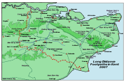
Medway Valley Walk
Encyclopedia
River Medway
The River Medway, which is almost entirely in Kent, England, flows for from just inside the West Sussex border to the point where it enters the Thames Estuary....
from Rochester to Tonbridge
Tonbridge
Tonbridge is a market town in the English county of Kent, with a population of 30,340 in 2007. It is located on the River Medway, approximately 4 miles north of Tunbridge Wells, 12 miles south west of Maidstone and 29 miles south east of London...
. Above Allington
Allington, Kent
Allington is an almost entirely modern village situated alongside the sides of the A20 road west of Maidstone in Kent. It is part of the built-up area of Maidstone. It has 2 primary schools; Allington Primary and Palace Wood...
, it follows the bank of the Medway Navigation
Medway Navigation
The River Medway in England flows for from Turners Hill, in West Sussex, through Tonbridge, Maidstone and the Medway Towns conurbation in Kent, to the River Thames at Sheerness, where it shares the latter's estuary. The Medway Navigation runs from the Leigh Barrier south of Tonbridge to Allington...
. It starts on the Saxon Shore Way
Saxon Shore Way
The Saxon Shore Way is a long-distance footpath in England, starting at Gravesend, Kent and traces the coast as it was in Roman times as far as Hastings, East Sussex, in total.-History:...
at Rochester. The North Downs Way
North Downs Way
The North Downs Way is a long-distance path in southern England, opened in 1978. It runs from Farnham to Dover, past Godalming, Guildford, Dorking, Merstham, Otford and Rochester, along the Surrey Hills Area of Outstanding Natural Beauty and Kent Downs AONB.East of Boughton Lees, the path splits...
crosses the Medway Valley Walk at the eastern end of the Medway Viaduct
Medway Viaduct
There are three Medway Viaducts, two of which carry the two carriageways of the M2 motorway. The other viaduct carries High Speed 1 across the River Medway near Rochester in north Kent, England.-M2 Motorway viaduct :...
or motorway bridge. The Greensand Way
Greensand Way
The Greensand Way is long distance walk of in southeast England, from Haslemere in Surrey to Hamstreet in Kent. It follows the Greensand Ridge along the Surrey Hills and Chart Hills. The route is mostly rural, passing through woods, and alongside fruit orchards and hop farms in Kent and links...
crosses the walk at Yalding
Yalding
Yalding is a village and part of Yalding civil parish in the Maidstone District of Kent, England.The village is situated six miles south-west of Maidstone at a point where the Rivers Teise and Beult join the River Medway....
. At West Peckham
West Peckham
West Peckham is a village in the local government district of Tonbridge and Malling in Kent, England. The River Bourne flows through the extreme west of the parish, and formerly powered a paper mill and corn mill . The Wateringbury Stream rises in the parish...
, it is joined by the Wealdway
Wealdway
The Wealdway, Kent and East Sussex, is a public footpath that runs from Gravesend, Kent on the Thames estuary, to the A259 at Eastbourne, 3 km north of Beachy Head....
which continues through to Tonbridge, thus linking with the Eden Valley Walk.
The Maidstone Millennium River Park is a 10 kilometre (6 mi) stretch from Teston
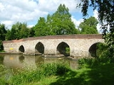
Teston
Teston is a village in the Maidstone District of Kent, England. It is located on the A26 road out of Maidstone, four miles from the town centre. There is a narrow stone bridge over the River Medway here....
Country Park to the Museum of Kent Life
Museum of Kent Life
Kent Life is an open air museum located at Sandling, next to Allington Locks on the east bank of the River Medway.- History :...
at Sandling
Sandling
Sandling is a small hamlet north of Saltwood in Kent. It has a railway station connected to Saltwood village by a bus service. It is also the location of Sandling Park, a large estate and house, which stretches around the village of Saltwood and ends at Saltwood's other satellite hamlet, Pedlinge...
. It follows the walk. The park was built between 1998 and 2001; it has transformed 18 acres (7.3 ha) of wasteland and led to the construction of three new footbridges over the river all accessible from the walk.