
Maryland Route 615
Encyclopedia
Maryland Route 615 is a state highway
in the U.S. state
of Maryland
. The state highway runs 4.35 miles (7 km) from Interstate 70
(I-70) and U.S. Route 40
(US 40) east of Hancock
north to the Pennsylvania
state line in western Washington County
. MD 615 has two sections, an east–west frontage road that parallels I-70 and a north–south highway that follows Heavenly Acres Ridge. The ridge road was constructed as MD 615 in the mid 1930s. The frontage road became part of an extended MD 615 in the early 1960s when I-70 was constructed east of Hancock, replacing two-lane US 40.
.
, the Western Maryland Railway
, and the National Pike, which ran between the canal and the railroad. The first two modes are preserved as the Chesapeake and Ohio Canal National Historical Park
and the Western Maryland Rail Trail
. When the Maryland State Roads Commission constructed the state road between Hancock and Licking Creek in 1915, the highway was placed on a new alignment north of the railroad tracks to avoid four grade crossings. This highway was designated US 40 in 1927.
The Heavenly Acres Ridge portion of MD 615 was paved from US 40 to the Pennsylvania state line in 1936. By 1939, White Oak Ridge Road was also marked as MD 615. White Oak Ridge Road retained the state highway designation until 1956. In 1960, US 40 was expanded to a freeway from Exit 3 in Hancock to what is now the eastern end of MD 615. This upgrade included the modern ramps to and from the freeway to Millstone Road. This freeway was marked as I-70 in addition to US 40 in 1962. MD 615 was extended south and east from Heavenly Acres Ridge Road along its modern extent. It is not clear if present day MD 615 follows the old two-lane US 40, or if the old US 40 was obliterated by the construction of the freeway and MD 615 is a service road to serve properties along the corridor.
in Washington County
.
{|class=wikitable
!Mile
!Destinations
!Notes
|-
|0.00
|Millstone Road east
|Southern terminus; Exit 5 ramp from westbound I-70 / US 40
|-
|0.39
|
|
|-
|1.83
|
|Exit 5 ramp from eastbound I-70 / US 40
|-
|4.35
|
|Northern terminus; Pennsylvania
state line
State highway
State highway, state road or state route can refer to one of three related concepts, two of them related to a state or provincial government in a country that is divided into states or provinces :#A...
in the U.S. state
U.S. state
A U.S. state is any one of the 50 federated states of the United States of America that share sovereignty with the federal government. Because of this shared sovereignty, an American is a citizen both of the federal entity and of his or her state of domicile. Four states use the official title of...
of Maryland
Maryland
Maryland is a U.S. state located in the Mid Atlantic region of the United States, bordering Virginia, West Virginia, and the District of Columbia to its south and west; Pennsylvania to its north; and Delaware to its east...
. The state highway runs 4.35 miles (7 km) from Interstate 70
Interstate 70 in Maryland
Interstate 70 is a part of the Interstate Highway System that runs from Cove Fort, Utah to Baltimore, Maryland. In Maryland, the Interstate Highway runs from the Pennsylvania state line in Hancock east to the Interstate's eastern terminus near its junction with I-695 at a park and ride in...
(I-70) and U.S. Route 40
U.S. Route 40 in Maryland
U.S. Route 40 in the U.S. state of Maryland runs from western Maryland to Cecil County in the state's northeastern corner. With a total length of over , it is the longest numbered highway in Maryland. Almost half of the road overlaps with Interstate 68 or Interstate 70, while the old alignment...
(US 40) east of Hancock
Hancock, Maryland
Hancock is a town in Washington County, Maryland, United States. The population was 1,725 at the 2000 census. The Western Maryland community is notable for being located at the narrowest part of the state...
north to the Pennsylvania
Pennsylvania
The Commonwealth of Pennsylvania is a U.S. state that is located in the Northeastern and Mid-Atlantic regions of the United States. The state borders Delaware and Maryland to the south, West Virginia to the southwest, Ohio to the west, New York and Ontario, Canada, to the north, and New Jersey to...
state line in western Washington County
Washington County, Maryland
Washington County is a county located in the western part of the U.S. state of Maryland, bordering southern Pennsylvania to the north, northern Virginia to the south, and the Eastern Panhandle of West Virginia to the south and west. As of the 2010 Census, its population is 147,430...
. MD 615 has two sections, an east–west frontage road that parallels I-70 and a north–south highway that follows Heavenly Acres Ridge. The ridge road was constructed as MD 615 in the mid 1930s. The frontage road became part of an extended MD 615 in the early 1960s when I-70 was constructed east of Hancock, replacing two-lane US 40.
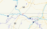
Route description
MD 615 begins at an intersection between Millstone Road, which continues east as a county highway, and the Exit 5 ramp from westbound I-70 and US 40 (Eisenhower Memorial Highway). After passing Hollow Road and a ramp to eastbound I-70 / US 40, the state highway heads west, closely paralleling I-70 and US 40 to the south. MD 615 continues west until it intersects the ramps to and from I-70 and US 40 in the direction of Hancock. The state highway, now known as Heavenly Acres Ridge Road, curves north to climb out of the narrow valley of the Potomac River onto Heavenly Acres Ridge. MD 615 follows the ridge north to an intersection with White Oak Ridge Road at the Pennsylvania state line. Heavenly Acres Ridge Road continues north as State Route 2001 in southeastern Fulton CountyFulton County, Pennsylvania
Fulton County is a county located in the U.S. state of Pennsylvania. As of 2010, the population was 14,845.Fulton County was created on April 19, 1850, from part of Bedford County and named for inventor Robert Fulton.Its county seat is McConnellsburg....
.
History
The Millstone Road portion of MD 615 follows a narrow corridor on the north side of the Potomac River that has carried multiple modes of transportation between Hancock and Licking Creek, where the river valley opens up. In the early 20th century, this corridor included the Chesapeake and Ohio CanalChesapeake and Ohio Canal
The Chesapeake and Ohio Canal, abbreviated as the C&O Canal, and occasionally referred to as the "Grand Old Ditch," operated from 1831 until 1924 parallel to the Potomac River in Maryland from Cumberland, Maryland to Washington, D.C. The total length of the canal is about . The elevation change of...
, the Western Maryland Railway
Western Maryland Railway
The Western Maryland Railway was an American Class I railroad which operated in Maryland, West Virginia, and Pennsylvania. It was primarily a coal hauling and freight railroad, with a small passenger train operation. The WM became part of the Chessie System in 1973 and ceased operating its lines...
, and the National Pike, which ran between the canal and the railroad. The first two modes are preserved as the Chesapeake and Ohio Canal National Historical Park
Chesapeake and Ohio Canal National Historical Park
The Chesapeake and Ohio Canal National Historical Park is a United States National Historical Park located in the District of Columbia and the states of Maryland and West Virginia. The park was established as a National Monument in 1961 by President Dwight D...
and the Western Maryland Rail Trail
Western Maryland Rail Trail
The Western Maryland Rail Trail is a long shared-use asphalt-paved rail trail from Fort Frederick to Pearre Station, Maryland, United States, that is suitable for walkers, joggers, bikers, rollerbladers and, weather permitting, cross country skiing....
. When the Maryland State Roads Commission constructed the state road between Hancock and Licking Creek in 1915, the highway was placed on a new alignment north of the railroad tracks to avoid four grade crossings. This highway was designated US 40 in 1927.
The Heavenly Acres Ridge portion of MD 615 was paved from US 40 to the Pennsylvania state line in 1936. By 1939, White Oak Ridge Road was also marked as MD 615. White Oak Ridge Road retained the state highway designation until 1956. In 1960, US 40 was expanded to a freeway from Exit 3 in Hancock to what is now the eastern end of MD 615. This upgrade included the modern ramps to and from the freeway to Millstone Road. This freeway was marked as I-70 in addition to US 40 in 1962. MD 615 was extended south and east from Heavenly Acres Ridge Road along its modern extent. It is not clear if present day MD 615 follows the old two-lane US 40, or if the old US 40 was obliterated by the construction of the freeway and MD 615 is a service road to serve properties along the corridor.
Junction list
The entire route is an unnamed area east of HancockHancock, Maryland
Hancock is a town in Washington County, Maryland, United States. The population was 1,725 at the 2000 census. The Western Maryland community is notable for being located at the narrowest part of the state...
in Washington County
Washington County, Maryland
Washington County is a county located in the western part of the U.S. state of Maryland, bordering southern Pennsylvania to the north, northern Virginia to the south, and the Eastern Panhandle of West Virginia to the south and west. As of the 2010 Census, its population is 147,430...
.
{|class=wikitable
!Mile
!Destinations
!Notes
|-
|0.00
|Millstone Road east
|Southern terminus; Exit 5 ramp from westbound I-70 / US 40
|-
|0.39
|
|
|-
|1.83
|
|Exit 5 ramp from eastbound I-70 / US 40
|-
|4.35
|
|Northern terminus; Pennsylvania
Pennsylvania
The Commonwealth of Pennsylvania is a U.S. state that is located in the Northeastern and Mid-Atlantic regions of the United States. The state borders Delaware and Maryland to the south, West Virginia to the southwest, Ohio to the west, New York and Ontario, Canada, to the north, and New Jersey to...
state line