
Maryland Route 405
Encyclopedia
Maryland Route 405 is a state highway
in the U.S. state
of Maryland
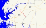
. Known as Price Station Road, the state highway runs 8.59 miles (13.8 km) from MD 304
near Bridgetown north to MD 19
near Church Hill
. MD 405 connects Church Hill and Bridgetown with the central Queen Anne's County
community of Price
, where the highway intersects U.S. Route 301
(US 301). The state highway was constructed from Price to south of Roe in the early 1930s and from Price to Church Hill in the mid 1930s. MD 405 was extended from Roe to Bridgetown in Caroline County
in the early 1940s. The Bridgetown end was truncated when MD 304 was extended east to Bridgetown in the mid 1960s.
at grade. Immediately beyond the railroad track, the state highway intersects the dual carriageways of US 301 (Blue Star Memorial Highway), which are separated by a wide median. MD 405 curves north at Flat Iron Square Road and bridges Southeast Branch before reaching its northern terminus at MD 19 (Roberts Station Road) south of Church Hill.
.
{|class=wikitable
!Location
!Mile
!Intersection
!Notes
|-
|Bridgetown
|0.00
|
|Southern terminus
|-
|rowspan=2|Price
|5.98
| – Wilmington
|
|-
|6.08
|
|
|-
|Church Hill
|8.59
|
|Northern terminus
State highway
State highway, state road or state route can refer to one of three related concepts, two of them related to a state or provincial government in a country that is divided into states or provinces :#A...
in the U.S. state
U.S. state
A U.S. state is any one of the 50 federated states of the United States of America that share sovereignty with the federal government. Because of this shared sovereignty, an American is a citizen both of the federal entity and of his or her state of domicile. Four states use the official title of...
of Maryland
Maryland
Maryland is a U.S. state located in the Mid Atlantic region of the United States, bordering Virginia, West Virginia, and the District of Columbia to its south and west; Pennsylvania to its north; and Delaware to its east...
. Known as Price Station Road, the state highway runs 8.59 miles (13.8 km) from MD 304
Maryland Route 304
Maryland Route 304 is a state highway in the U.S. state of Maryland. The state highway runs from Spider Web Road west of Centreville east to MD 312 in Bridgetown. MD 304 connects Centreville with U.S. Route 301 and several small settlements in central Queen Anne's County and northern Caroline,...
near Bridgetown north to MD 19
Maryland Route 19
Maryland Route 19 is a state highway in the U.S. state of Maryland. Known for much of its length as Roberts Station Road, the state highway runs from MD 213 in Church Hill east to MD 313 in Ingleside. MD 19 runs through central Queen Anne's County, connecting both communities with U.S. Route...
near Church Hill
Church Hill, Maryland
Church Hill is a town in Queen Anne's County, Maryland, United States. The population was 530 at the 2000 census. Joshua Seney was born near Church Hill, and is buried on his property near the town.-Geography:...
. MD 405 connects Church Hill and Bridgetown with the central Queen Anne's County
Queen Anne's County, Maryland
Queen Anne's County is a county located on the Eastern Shore of the U.S. state of Maryland.As of 2010, the population was 47,798. Its county seat and most populous municipality is Centreville. The census-designated place of Stevensville is the county's most populous place...
community of Price
Price, Maryland
Price is an unincorporated community in Queen Anne's County, Maryland, United States. Price is located at the junction of U.S. Route 301 and Maryland Route 405 south-southeast of Church Hill. Price has a post office with ZIP code 21656....
, where the highway intersects U.S. Route 301
U.S. Route 301 in Maryland
U.S. Route 301 in Maryland is a major highway that runs from Delaware to the Governor Harry W. Nice Memorial Bridge into Virginia. It passes through three of Maryland's four main regions: the Eastern Shore, the Baltimore-Washington Metropolitan Area, and Southern Maryland...
(US 301). The state highway was constructed from Price to south of Roe in the early 1930s and from Price to Church Hill in the mid 1930s. MD 405 was extended from Roe to Bridgetown in Caroline County
Caroline County, Maryland
Caroline County is a wholly rural county located in the U.S. state of Maryland on its Eastern Shore. It is bordered by Queen Anne's County to the north, Talbot County to the west, Dorchester County to the south, Kent County, Delaware, to the east, and Sussex County, Delaware, to the southeast. As...
in the early 1940s. The Bridgetown end was truncated when MD 304 was extended east to Bridgetown in the mid 1960s.
Route description
MD 405 begins at an intersection with MD 304 (Ruthsburg Road) west of Bridgetown. The state highway heads northwest through farmland as two-lane Prince Station Road, passing Shawn Road before intersecting Hope Road and Roe Ingleside Road in the hamlet of Roe. After crossing German Branch and passing Roseville Memorial Cemetery, MD 405 reaches the hamlet of Price, where it crosses the Centreville Branch of the Northern Line of the Maryland and Delaware RailroadMaryland and Delaware Railroad
The Maryland and Delaware Railroad Company is a Class III short-line railroad, formed in 1977 to operate several branch lines of the former Penn Central Railroad in both Maryland and Delaware. These branches were omitted from the system plan for Conrail in 1976 and would have been discontinued...
at grade. Immediately beyond the railroad track, the state highway intersects the dual carriageways of US 301 (Blue Star Memorial Highway), which are separated by a wide median. MD 405 curves north at Flat Iron Square Road and bridges Southeast Branch before reaching its northern terminus at MD 19 (Roberts Station Road) south of Church Hill.
History
The first section of MD 405 was paved from the railroad track south a short distance through Price by 1930. That highway was extended in two sections that were started in 1930: the highway between Roe and Shawn Road south of Roe was completed in 1932, while the segment between Roe and the existing road at Price was completed in 1933. MD 405 from MD 19 south to Flat Iron Square Road was also completed in 1933. The gap between Price and Church Hill was filled in 1935. The highway from Shawn Road south and then east along present day MD 304 to Bridgetown was constructed between 1940 and 1942. MD 405's southern terminus was moved to its present location when MD 304 was extended east from Ruthsburg to Bridgetown in 1964.Junction list
The entire route is in Queen Anne's CountyQueen Anne's County, Maryland
Queen Anne's County is a county located on the Eastern Shore of the U.S. state of Maryland.As of 2010, the population was 47,798. Its county seat and most populous municipality is Centreville. The census-designated place of Stevensville is the county's most populous place...
.
{|class=wikitable
!Location
!Mile
!Intersection
!Notes
|-
|Bridgetown
|0.00
|
|Southern terminus
|-
|rowspan=2|Price
Price, Maryland
Price is an unincorporated community in Queen Anne's County, Maryland, United States. Price is located at the junction of U.S. Route 301 and Maryland Route 405 south-southeast of Church Hill. Price has a post office with ZIP code 21656....
|5.98
| – Wilmington
Wilmington, Delaware
Wilmington is the largest city in the state of Delaware, United States, and is located at the confluence of the Christina River and Brandywine Creek, near where the Christina flows into the Delaware River. It is the county seat of New Castle County and one of the major cities in the Delaware Valley...
|
|-
|6.08
|
|
|-
|Church Hill
Church Hill, Maryland
Church Hill is a town in Queen Anne's County, Maryland, United States. The population was 530 at the 2000 census. Joshua Seney was born near Church Hill, and is buried on his property near the town.-Geography:...
|8.59
|
|Northern terminus