
Maryland Route 231
Encyclopedia
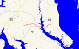
Maryland Route 231 (MD 231) is a state highway
in the U.S. state
of Maryland
. The state highway runs 16.39 miles (26.4 km) from Olivers Shop Road near Hughesville
east to MD 765
in Prince Frederick
. MD 231 crosses the Patuxent River
on the Benedict Bridge, which connects Benedict
in eastern Charles County
with Hallowing Point in central Calvert County
. Due to the state highway serving as the sole connection between the two areas of Southern Maryland
, MD 231 is part of the National Highway System
between MD 5
in Hughesville and MD 2
and MD 4
in Prince Frederick.
MD 231 was constructed from Hughesville to Benedict and from Hollowing Point to Prince Frederick in the early 1920s. The portion of the state highway west of Hughesville was built in the early 1930s, about the same time ferry service began between Benedict and Hallowing Point. The Benedict Bridge was started in 1950 and was completed in 1952; the bridge remained the southernmost crossing of the Patuxent River for 25 years. The bridge was tolled from its opening until around 1955. MD 231 was reconstructed between Hughesville and Prince Frederick in the mid- to late 1950s to better serve intercounty traffic.
to the south with Bryantown
to the north. MD 231 heads east as two-lane Burnt Store Road, crossing Gilbert Creek on its way to Hughesville. Within Hughesville, the state highway intersects MD 5 Business (Old Leonardtown Road), where the highway's name changes to Prince Frederick Road. East of the village center, MD 231 meets MD 5 (Leonardtown Road) at a dumbbell interchange. In the hamlet of Patuxent
, the state highway intersects MD 381
(Brandywine Road), which heads north into the southeastern corner of Prince George's County
.
From Patuxent, MD 231 heads southeast through the neck of far eastern Charles County that reaches to the Patuxent River between Prince George's County and St. Mary's County. Before reaching the river, the state highway passes to the north of the village of Benedict
, which was the site of the landing of British
troops to march toward Washington
prior to the Battle of Bladensburg
during the War of 1812
. The state highway crosses the Patuxent River on the Benedict Bridge, 3343 feet (1,018.9 m) long steel beam bridge whose roadway is 24 feet (7.3 m) wide. At the Patuxent River's navigation channel, the bridge features a through steel girder
swing span that has 17 feet (5.2 m) vertical clearance when closed and provides two openings with 50 feet (15.2 m) horizontal clearance when opened.
MD 231 enters Calvert County at Hallowing Point and continues east as Hallowing Point Road, passing an industrial park and Hallowing Point Park. After intersecting MD 508
(Adelina Road), the state highway veers northeast through the village of Barstow
, where the highway intersects Barstow Road, which serves the historic homes Cedar Hill
and Willow Glenn
. MD 231 passes the Prince Frederick campus of the College of Southern Maryland
before entering Prince Frederick. The state highway meets MD 2 and MD 4, which run concurrently
as Solomons Island Road, on the west side of the county seat. MD 231 continues northeast as Church Street, passing the historic home Linden
, home of the Calvert County Historical Society. The state highway reaches its eastern terminus at MD 765 (Main Street), a short distance north of the county courthouse.
at Wicomico north to what was then MD 233 (Woodville Road) north of Bryantown. MD 232 was removed from the state highway system around 1989, leaving MD 231's western terminus at a county highway.
Ferry service began between Benedict and Hallowing Point began around 1933. On the west side of the Patuxent River, MD 231 originally turned south into the village of Benedict, following Benedict Avenue to the ferry terminal where the avenue starting following the riverbank. The Hallowing Point terminal remains today as a boat ramp immediately south of the bridge. State senator Louis L. Goldstein
of Calvert County sponsored a bill to construct a bridge between Benedict and Hallowing Point. In order to get enough votes to pass, the bridge bill stipulated the bridge would have a 25-cent toll. Work on the Benedict Bridge began in May 1950. The toll plaza and administration building were completed on the Calvert County side of the bridge in autumn 1951. The bridge itself and 24 feet (7.3 m) wide gravel approach roads on both sides of the river were completed and opened in spring 1952. The toll was removed from the bridge in 1955 due to very low traffic; a daily average of 237 vehicles used the bridge in its first year. By comparison, the bridge had an average annual daily traffic figure of 11,931 vehicles in 2009.
The completion of the Benedict Bridge greatly improved the connection between Calvert County and both Charles and St. Mary's counties. Prior to 1952, the southernmost bridge on the Patuxent River had been Hills Bridge, by which MD 4 crosses the river at Upper Marlboro
. By 1953, MD 231 between MD 5 in Hughesville and MD 2 in Prince Frederick was marked as a "main highway" on the state highway map. Reconstruction of MD 231 between MD 5 and MD 2 began in 1954. In both counties, the road was resurfaced in two stages: a first stage of bituminous stabilized gravel and a second stage of bituminous concrete. The reconstruction of MD 231 was completed from Prince Frederick to Hallowing Point in 1956 and from Hughesville to Benedict by 1958. The Benedict Bridge remained the southernmost crossing of the Patuxent River until the opening of the Governor Thomas Johnson Bridge between Solomons
at the bottom of Calvert County and California
in St. Mary's County in 1978. The "functionally obsolete" bridge underwent major repairs in 2002, during which the bridge was reduced to one lane of traffic in alternating directions.
!County
!Location
!Mile
!Destinations
!Notes
|-
|rowspan=5|Charles
|
|0.00
|Olivers Shop Road – Dentsville
, Bryantown
|Western terminus; former MD 232
|-
|rowspan=2|Hughesville
|3.40
|
|Marked as MD 5 Business but officially MD 625
|-
|3.71
|
|Dumbbell interchange
|-
|Patuxent
|5.54
|
|
|-
|Benedict
|10.20
|rowspan=2 colspan=2 align=center|Benedict Bridge – Patuxent River
|-10.52
|rowspan=4|Calvert
|
|10.84
|-
|Barstow
|13.22
|
|
|-
|rowspan=2|Prince Frederick
|16.08
|
|
|-
|16.39
|
|Eastern terminus; officially MD 765A
State highway
State highway, state road or state route can refer to one of three related concepts, two of them related to a state or provincial government in a country that is divided into states or provinces :#A...
in the U.S. state
U.S. state
A U.S. state is any one of the 50 federated states of the United States of America that share sovereignty with the federal government. Because of this shared sovereignty, an American is a citizen both of the federal entity and of his or her state of domicile. Four states use the official title of...
of Maryland
Maryland
Maryland is a U.S. state located in the Mid Atlantic region of the United States, bordering Virginia, West Virginia, and the District of Columbia to its south and west; Pennsylvania to its north; and Delaware to its east...
. The state highway runs 16.39 miles (26.4 km) from Olivers Shop Road near Hughesville
Hughesville, Maryland
Hughesville is a census-designated place in Charles County, Maryland, United States. The population was 1,537 at the 2000 census. Truman's Place was listed on the National Register of Historic Places in 1988.-Geography:...
east to MD 765
Maryland Route 765
Maryland Route 765 is a collection of state highways in the U.S. state of Maryland. These 26 highways are service roads constructed or old alignments maintained to provide access to private property or county highways whose access was compromised by the realignment of MD 2 and MD 4 in Calvert...
in Prince Frederick
Prince Frederick, Maryland
Prince Frederick is a census-designated place in Calvert County, Maryland, United States, not to be confused with the incorporated, and much larger, city of Frederick some to the northwest in Frederick County...
. MD 231 crosses the Patuxent River
Patuxent River
The Patuxent River is a tributary of the Chesapeake Bay in the state of Maryland. There are three main river drainages for central Maryland: the Potomac River to the west passing through Washington D.C., the Patapsco River to the northeast passing through Baltimore, and the Patuxent River between...
on the Benedict Bridge, which connects Benedict
Benedict, Maryland
Benedict, Maryland is a small unincorporated town in Charles County, Maryland, located on the Patuxent River in Southern Maryland, USA.-History:...
in eastern Charles County
Charles County, Maryland
Charles County is a county in the south central portion of the U.S. state of Maryland.As of 2010, the population was 146,551. Its county seat is La Plata. This county was named for Charles Calvert , third Baron Baltimore....
with Hallowing Point in central Calvert County
Calvert County, Maryland
Calvert County is a county located in the U.S. state of Maryland. It occupies the Calvert Peninsula which is bordered on the east by the Chesapeake Bay and on the west by the Patuxent River. Calvert County is part of the Southern Maryland region. Calvert County's residents are among the highest...
. Due to the state highway serving as the sole connection between the two areas of Southern Maryland
Southern Maryland
Southern Maryland in popular usage is composed of the state's southernmost counties on the "Western Shore" of the Chesapeake Bay. This region includes all of Calvert, Charles and St. Mary's counties and sometimes the southern portions of Anne Arundel and Prince George's counties.- History...
, MD 231 is part of the National Highway System
National Highway System (United States)
The National Highway System is a network of strategic highways within the United States, including the Interstate Highway System and other roads serving major airports, ports, rail or truck terminals, railway stations, pipeline terminals and other strategic transport facilities.Individual states...
between MD 5
Maryland Route 5
Maryland Route 5 is a long state highway that runs north–south in the U.S. state of Maryland. The highway runs from Point Lookout in St. Mary's County north to the Washington, D.C. border in Suitland, Prince George's County....
in Hughesville and MD 2
Maryland Route 2
Maryland Route 2 is the longest state highway in the U.S. state of Maryland. The route runs from Solomons Island in Calvert County north to an intersection with U.S. Route 1 and U.S. Route 40 Truck in Baltimore...
and MD 4
Maryland Route 4
Maryland Route 4 is a state highway in the U.S. state of Maryland. The state highway runs from MD 5 in Leonardtown north to Southern Avenue at the Washington, D.C. border, past which the highway continues as Pennsylvania Avenue...
in Prince Frederick.
MD 231 was constructed from Hughesville to Benedict and from Hollowing Point to Prince Frederick in the early 1920s. The portion of the state highway west of Hughesville was built in the early 1930s, about the same time ferry service began between Benedict and Hallowing Point. The Benedict Bridge was started in 1950 and was completed in 1952; the bridge remained the southernmost crossing of the Patuxent River for 25 years. The bridge was tolled from its opening until around 1955. MD 231 was reconstructed between Hughesville and Prince Frederick in the mid- to late 1950s to better serve intercounty traffic.
Route description
MD 231 begins at an intersection with Olivers Shop Road in the hamlet of Burnt Store in eastern Charles County. Olivers Shop Road connects DentsvilleDentsville, Maryland
Dentsville is an unincorporated community in Charles County, Maryland, United States, marked by a convenience store in operation since 1906, and adjacent small businesses, including the Dentsville Rescue Squad and Auxiliary founded in 1998 on Maryland Route 6 east of La Plata. It was named after...
to the south with Bryantown
Bryantown, Maryland
Bryantown is an unincorporated community in Charles County, Maryland, United States, adjacent to Maryland Route 5. Bryantown stands on land known as Boarman's Manor, a manor granted to Major William Boarman in 1674....
to the north. MD 231 heads east as two-lane Burnt Store Road, crossing Gilbert Creek on its way to Hughesville. Within Hughesville, the state highway intersects MD 5 Business (Old Leonardtown Road), where the highway's name changes to Prince Frederick Road. East of the village center, MD 231 meets MD 5 (Leonardtown Road) at a dumbbell interchange. In the hamlet of Patuxent
Patuxent, Maryland
Patuxent is an unincorporated community in Charles County, Maryland, United States. Maxwell Hall was listed on the National Register of Historic Places in 1974....
, the state highway intersects MD 381
Maryland Route 381
Maryland Route 381 is a state highway in Charles County and Prince George's County. It begins by branching off of MD 231 in eastern Charles County and heads north for before crossing into the south-eastern tip of Prince George's County...
(Brandywine Road), which heads north into the southeastern corner of Prince George's County
Prince George's County, Maryland
Prince George's County is a county located in the U.S. state of Maryland, immediately north, east, and south of Washington, DC. As of 2010, it has a population of 863,420 and is the wealthiest African-American majority county in the nation....
.
From Patuxent, MD 231 heads southeast through the neck of far eastern Charles County that reaches to the Patuxent River between Prince George's County and St. Mary's County. Before reaching the river, the state highway passes to the north of the village of Benedict
Benedict, Maryland
Benedict, Maryland is a small unincorporated town in Charles County, Maryland, located on the Patuxent River in Southern Maryland, USA.-History:...
, which was the site of the landing of British
British people
The British are citizens of the United Kingdom, of the Isle of Man, any of the Channel Islands, or of any of the British overseas territories, and their descendants...
troops to march toward Washington
Washington, D.C.
Washington, D.C., formally the District of Columbia and commonly referred to as Washington, "the District", or simply D.C., is the capital of the United States. On July 16, 1790, the United States Congress approved the creation of a permanent national capital as permitted by the U.S. Constitution....
prior to the Battle of Bladensburg
Battle of Bladensburg
The Battle of Bladensburg took place during the War of 1812. The defeat of the American forces there allowed the British to capture and burn the public buildings of Washington, D.C...
during the War of 1812
War of 1812
The War of 1812 was a military conflict fought between the forces of the United States of America and those of the British Empire. The Americans declared war in 1812 for several reasons, including trade restrictions because of Britain's ongoing war with France, impressment of American merchant...
. The state highway crosses the Patuxent River on the Benedict Bridge, 3343 feet (1,018.9 m) long steel beam bridge whose roadway is 24 feet (7.3 m) wide. At the Patuxent River's navigation channel, the bridge features a through steel girder
Girder
A girder is a support beam used in construction. Girders often have an I-beam cross section for strength, but may also have a box shape, Z shape or other forms. Girder is the term used to denote the main horizontal support of a structure which supports smaller beams...
swing span that has 17 feet (5.2 m) vertical clearance when closed and provides two openings with 50 feet (15.2 m) horizontal clearance when opened.
MD 231 enters Calvert County at Hallowing Point and continues east as Hallowing Point Road, passing an industrial park and Hallowing Point Park. After intersecting MD 508
Maryland Route 508
Maryland Route 508 is a state highway in the U.S. state of Maryland. Known as Adelina Road, the state highway runs from MD 506 in Bowens north to MD 231 near Barstow. MD 508 was constructed in the early 1930s from MD 231 to Adelina. The southern terminus was rolled back to Bowens in the late...
(Adelina Road), the state highway veers northeast through the village of Barstow
Barstow, Maryland
Barstow is a small, rural unincorporated community in Calvert County, Maryland located immediately west of Prince Frederick. The community maintains its own separate zip code, 20610....
, where the highway intersects Barstow Road, which serves the historic homes Cedar Hill
Cedar Hill (Barstow, Maryland)
Cedar Hill is a historic home located on at Barstow, Calvert County, Maryland, United States. It is one of the few remaining cruciform dwelling houses existing in Maryland, built in the 18th century that is typical of 17th century architecture. It is a -story house with a 2-story porch tower,...
and Willow Glenn
Willow Glenn
Willow Glenn is a historic home located at Barstow, Calvert County, Maryland, United States. It is an impressive, Georgian structure of grand proportions; constructed entirely of brick in Flemish bond with random glazed headers...
. MD 231 passes the Prince Frederick campus of the College of Southern Maryland
College of Southern Maryland
The College of Southern Maryland in La Plata, Maryland, is a public, regional community college, serving Southern Maryland Charles County, St. Mary's County, and Calvert County.-History:...
before entering Prince Frederick. The state highway meets MD 2 and MD 4, which run concurrently
Concurrency (road)
A concurrency, overlap, or coincidence in a road network is an instance of one physical road bearing two or more different highway, motorway, or other route numbers...
as Solomons Island Road, on the west side of the county seat. MD 231 continues northeast as Church Street, passing the historic home Linden
Linden (Prince Frederick, Maryland)
Linden is a historic home located at Prince Frederick, Calvert County, Maryland. It is a two-story frame house, conservatively Italianate in style built about 1868, with conservative Colonial Revival additions of about 1907. Behind the house are ten standing outbuildings, seven dating to the 19th...
, home of the Calvert County Historical Society. The state highway reaches its eastern terminus at MD 765 (Main Street), a short distance north of the county courthouse.
History
The Prince Frederick Road portion of MD 231, originally named Benedict Road, was constructed as a gravel road by 1921. The Hallowing Point Road section was built in gravel around 1923. Burnt Store Road was constructed of gravel starting in 1930 and was completed by 1933. At MD 231's western terminus, Olivers Shop Road was originally MD 232, which ran from MD 234Maryland Route 234
Maryland Route 234 is a state highway in the U.S. state of Maryland. Known as Budds Creek Road, the state highway runs from U.S. Route 301 in Allens Fresh east to MD 5 in Leonardtown. MD 234 is the primary east–west highway of southern Charles County and western St...
at Wicomico north to what was then MD 233 (Woodville Road) north of Bryantown. MD 232 was removed from the state highway system around 1989, leaving MD 231's western terminus at a county highway.
Ferry service began between Benedict and Hallowing Point began around 1933. On the west side of the Patuxent River, MD 231 originally turned south into the village of Benedict, following Benedict Avenue to the ferry terminal where the avenue starting following the riverbank. The Hallowing Point terminal remains today as a boat ramp immediately south of the bridge. State senator Louis L. Goldstein
Louis L. Goldstein
Louis Lazarus Goldstein served as Comptroller, or chief financial officer, of Maryland from 1959 to 1998. He was born to a storekeeper in the small town of Prince Frederick, Maryland, and also died there. As a legislator in the Maryland General Assembly, he was known for his 11th-hour strong...
of Calvert County sponsored a bill to construct a bridge between Benedict and Hallowing Point. In order to get enough votes to pass, the bridge bill stipulated the bridge would have a 25-cent toll. Work on the Benedict Bridge began in May 1950. The toll plaza and administration building were completed on the Calvert County side of the bridge in autumn 1951. The bridge itself and 24 feet (7.3 m) wide gravel approach roads on both sides of the river were completed and opened in spring 1952. The toll was removed from the bridge in 1955 due to very low traffic; a daily average of 237 vehicles used the bridge in its first year. By comparison, the bridge had an average annual daily traffic figure of 11,931 vehicles in 2009.
The completion of the Benedict Bridge greatly improved the connection between Calvert County and both Charles and St. Mary's counties. Prior to 1952, the southernmost bridge on the Patuxent River had been Hills Bridge, by which MD 4 crosses the river at Upper Marlboro
Upper Marlboro, Maryland
Upper Marlboro is a town in and the county seat of Prince George's County, Maryland, United States. The live-in population of the town core proper was only 648 at the 2000 census, although Greater Upper Marlboro is many times larger....
. By 1953, MD 231 between MD 5 in Hughesville and MD 2 in Prince Frederick was marked as a "main highway" on the state highway map. Reconstruction of MD 231 between MD 5 and MD 2 began in 1954. In both counties, the road was resurfaced in two stages: a first stage of bituminous stabilized gravel and a second stage of bituminous concrete. The reconstruction of MD 231 was completed from Prince Frederick to Hallowing Point in 1956 and from Hughesville to Benedict by 1958. The Benedict Bridge remained the southernmost crossing of the Patuxent River until the opening of the Governor Thomas Johnson Bridge between Solomons
Solomons, Maryland
Solomons is a community and census-designated place in Calvert County, Maryland, United States. The population was 1,536 at the 2000 census...
at the bottom of Calvert County and California
California, Maryland
California is a census-designated place and community in St. Mary's County, Maryland, United States. The population was 9,307 at the 2000 census. California continues to grow with the spread of population out from the older adjacent community of Lexington Park and the growth in both...
in St. Mary's County in 1978. The "functionally obsolete" bridge underwent major repairs in 2002, during which the bridge was reduced to one lane of traffic in alternating directions.
Junction list
{| class=wikitable!County
!Location
!Mile
!Destinations
!Notes
|-
|rowspan=5|Charles
Charles County, Maryland
Charles County is a county in the south central portion of the U.S. state of Maryland.As of 2010, the population was 146,551. Its county seat is La Plata. This county was named for Charles Calvert , third Baron Baltimore....
|
|0.00
|Olivers Shop Road – Dentsville
Dentsville, Maryland
Dentsville is an unincorporated community in Charles County, Maryland, United States, marked by a convenience store in operation since 1906, and adjacent small businesses, including the Dentsville Rescue Squad and Auxiliary founded in 1998 on Maryland Route 6 east of La Plata. It was named after...
, Bryantown
Bryantown, Maryland
Bryantown is an unincorporated community in Charles County, Maryland, United States, adjacent to Maryland Route 5. Bryantown stands on land known as Boarman's Manor, a manor granted to Major William Boarman in 1674....
|Western terminus; former MD 232
|-
|rowspan=2|Hughesville
Hughesville, Maryland
Hughesville is a census-designated place in Charles County, Maryland, United States. The population was 1,537 at the 2000 census. Truman's Place was listed on the National Register of Historic Places in 1988.-Geography:...
|3.40
|
|Marked as MD 5 Business but officially MD 625
|-
|3.71
|
|Dumbbell interchange
|-
|Patuxent
Patuxent, Maryland
Patuxent is an unincorporated community in Charles County, Maryland, United States. Maxwell Hall was listed on the National Register of Historic Places in 1974....
|5.54
|
|
|-
|Benedict
Benedict, Maryland
Benedict, Maryland is a small unincorporated town in Charles County, Maryland, located on the Patuxent River in Southern Maryland, USA.-History:...
|10.20
|rowspan=2 colspan=2 align=center|Benedict Bridge – Patuxent River
Patuxent River
The Patuxent River is a tributary of the Chesapeake Bay in the state of Maryland. There are three main river drainages for central Maryland: the Potomac River to the west passing through Washington D.C., the Patapsco River to the northeast passing through Baltimore, and the Patuxent River between...
|-10.52
|rowspan=4|Calvert
Calvert County, Maryland
Calvert County is a county located in the U.S. state of Maryland. It occupies the Calvert Peninsula which is bordered on the east by the Chesapeake Bay and on the west by the Patuxent River. Calvert County is part of the Southern Maryland region. Calvert County's residents are among the highest...
|
|10.84
|-
|Barstow
Barstow, Maryland
Barstow is a small, rural unincorporated community in Calvert County, Maryland located immediately west of Prince Frederick. The community maintains its own separate zip code, 20610....
|13.22
|
|
|-
|rowspan=2|Prince Frederick
Prince Frederick, Maryland
Prince Frederick is a census-designated place in Calvert County, Maryland, United States, not to be confused with the incorporated, and much larger, city of Frederick some to the northwest in Frederick County...
|16.08
|
|
|-
|16.39
|
|Eastern terminus; officially MD 765A