
Maryland Route 381
Encyclopedia
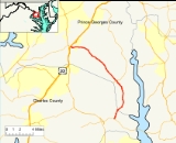
Maryland Route 381 is a state highway in Charles County
and Prince George's County
. It begins by branching off of MD 231
(Prince Frederick Road) in eastern Charles County and heads north for 1.38 miles (2.2 km) before crossing into the south-eastern tip of Prince George's County. In Prince George's County, it continues onwards through mostly rural areas and the unincorporated communities
of Aquasco
and Baden before reaching its northern terminus at US 301
in Brandywine
.
The portion of Route 381 from MD 231 up until the intersection with MD 382
(Croom Road) is a component of the Maryland Scenic Byways system as Byway #13, Star-Spangled Banner.
It is a two-lane highway, aligned north–south, and runs for a total length of 15.91 miles (25.6 km).
(Prince Frederick Road) in eastern Charles County and heads north for 1.38 miles (2.2 km), serving residences along its path, before crossing into the south-eastern tip of Prince George's County over Swanson Creek. In Prince George's County, it immediately passes over a railroad alignment and continues onwards through heavily wooded rural areas, with some farmland lining the route. It passes through the unincorporated community
of Aquasco
and Baden, where it intersects MD 382 (Croom Road). Many homes and important facilities are served over a long stretch of the route before it returns to woodland, curving to the northwest. As it enters Brandywine
, it crosses three sets of railroad tracks and is intersected by several city streets before reaching its northern terminus at US 301
.
Beyond the official end of MD 381 and state maintenance, Brandywine Road continues on to an intersection with MD 373
(Accokeek Road) and further on, a signal-controlled intersection with MD 5
(Branch Ave). It then crosses over MD 5 into a series of suburban areas until it terminates in Clinton
at Woodyard Road / Piscataway Road (MD 223
). This configuration is subject to change in the future depending on the results of a MDSHA
project to revamp the MD 5 / MD 373 / Brandywine Road interchange.
Charles County, Maryland
Charles County is a county in the south central portion of the U.S. state of Maryland.As of 2010, the population was 146,551. Its county seat is La Plata. This county was named for Charles Calvert , third Baron Baltimore....
and Prince George's County
Prince George's County, Maryland
Prince George's County is a county located in the U.S. state of Maryland, immediately north, east, and south of Washington, DC. As of 2010, it has a population of 863,420 and is the wealthiest African-American majority county in the nation....
. It begins by branching off of MD 231
Maryland Route 231
Maryland Route 231 is a state highway in the U.S. state of Maryland. The state highway runs from Olivers Shop Road near Hughesville east to MD 765 in Prince Frederick. MD 231 crosses the Patuxent River on the Benedict Bridge, which connects Benedict in eastern Charles County...
(Prince Frederick Road) in eastern Charles County and heads north for 1.38 miles (2.2 km) before crossing into the south-eastern tip of Prince George's County. In Prince George's County, it continues onwards through mostly rural areas and the unincorporated communities
Unincorporated area
In law, an unincorporated area is a region of land that is not a part of any municipality.To "incorporate" in this context means to form a municipal corporation, a city, town, or village with its own government. An unincorporated community is usually not subject to or taxed by a municipal government...
of Aquasco
Aquasco, Maryland
Aquasco is an unincorporated area in southeastern Prince George's County, Maryland, United States, located near Eagle Harbor and Charles County. It was home to the Aquasco Speedway....
and Baden before reaching its northern terminus at US 301
U.S. Route 301 in Maryland
U.S. Route 301 in Maryland is a major highway that runs from Delaware to the Governor Harry W. Nice Memorial Bridge into Virginia. It passes through three of Maryland's four main regions: the Eastern Shore, the Baltimore-Washington Metropolitan Area, and Southern Maryland...
in Brandywine
Brandywine, Maryland
Brandywine is an unincorporated area and census-designated place in Prince George's County, Maryland, United States, although the postal delivery area includes part of Charles County as well near Malcolm....
.
The portion of Route 381 from MD 231 up until the intersection with MD 382
Maryland Route 382
Maryland Route 382 is a state highway in Prince George's County. It begins after a small bridge crosses County Line Creek , and it heads north until its northern terminus at US 301 in Marlton.Route 382 is also a component of the Maryland Scenic Byways system as Byway #13, Star-Spangled...
(Croom Road) is a component of the Maryland Scenic Byways system as Byway #13, Star-Spangled Banner.
It is a two-lane highway, aligned north–south, and runs for a total length of 15.91 miles (25.6 km).
Route description
It begins by branching off of MD 231Maryland Route 231
Maryland Route 231 is a state highway in the U.S. state of Maryland. The state highway runs from Olivers Shop Road near Hughesville east to MD 765 in Prince Frederick. MD 231 crosses the Patuxent River on the Benedict Bridge, which connects Benedict in eastern Charles County...
(Prince Frederick Road) in eastern Charles County and heads north for 1.38 miles (2.2 km), serving residences along its path, before crossing into the south-eastern tip of Prince George's County over Swanson Creek. In Prince George's County, it immediately passes over a railroad alignment and continues onwards through heavily wooded rural areas, with some farmland lining the route. It passes through the unincorporated community
Unincorporated area
In law, an unincorporated area is a region of land that is not a part of any municipality.To "incorporate" in this context means to form a municipal corporation, a city, town, or village with its own government. An unincorporated community is usually not subject to or taxed by a municipal government...
of Aquasco
Aquasco, Maryland
Aquasco is an unincorporated area in southeastern Prince George's County, Maryland, United States, located near Eagle Harbor and Charles County. It was home to the Aquasco Speedway....
and Baden, where it intersects MD 382 (Croom Road). Many homes and important facilities are served over a long stretch of the route before it returns to woodland, curving to the northwest. As it enters Brandywine
Brandywine, Maryland
Brandywine is an unincorporated area and census-designated place in Prince George's County, Maryland, United States, although the postal delivery area includes part of Charles County as well near Malcolm....
, it crosses three sets of railroad tracks and is intersected by several city streets before reaching its northern terminus at US 301
U.S. Route 301 in Maryland
U.S. Route 301 in Maryland is a major highway that runs from Delaware to the Governor Harry W. Nice Memorial Bridge into Virginia. It passes through three of Maryland's four main regions: the Eastern Shore, the Baltimore-Washington Metropolitan Area, and Southern Maryland...
.
Beyond the official end of MD 381 and state maintenance, Brandywine Road continues on to an intersection with MD 373
Maryland Route 373
Maryland Route 373 is a state highway in Prince George's County. It begins at the intersection with MD 210 and Livingston Road. It runs east through the unincorporated communities of Accokeek and Brandywine and crosses over MD 5 before terminating at the county-maintained portion of Brandywine...
(Accokeek Road) and further on, a signal-controlled intersection with MD 5
Maryland Route 5
Maryland Route 5 is a long state highway that runs north–south in the U.S. state of Maryland. The highway runs from Point Lookout in St. Mary's County north to the Washington, D.C. border in Suitland, Prince George's County....
(Branch Ave). It then crosses over MD 5 into a series of suburban areas until it terminates in Clinton
Clinton, Maryland
Clinton is an unincorporated area and census-designated place in Prince George's County, Maryland, United States. Clinton was formerly known as Surrattsville until after the time of the American Civil War. The population of Clinton was 26,064 at the 2000 census. However, as of 2007, there is an...
at Woodyard Road / Piscataway Road (MD 223
Maryland Route 223
Maryland Route 223 is a state highway in the U.S. state of Maryland. The state highway runs from Livingston Road in Piscataway north to Mellwood Road in Mellwood...
). This configuration is subject to change in the future depending on the results of a MDSHA
Maryland State Highway Administration
The Maryland State Highway Administration is the state agency responsible for maintaining Maryland numbered highways outside of Baltimore City...
project to revamp the MD 5 / MD 373 / Brandywine Road interchange.
Junction list
| County | Location | Mile |
Intersection | Notes |
|---|---|---|---|---|
| Charles County Charles County, Maryland Charles County is a county in the south central portion of the U.S. state of Maryland.As of 2010, the population was 146,551. Its county seat is La Plata. This county was named for Charles Calvert , third Baron Baltimore.... |
Hughesville Hughesville, Maryland Hughesville is a census-designated place in Charles County, Maryland, United States. The population was 1,537 at the 2000 census. Truman's Place was listed on the National Register of Historic Places in 1988.-Geography:... |
0.00 | Southern terminus | |
| Prince George's County Prince George's County, Maryland Prince George's County is a county located in the U.S. state of Maryland, immediately north, east, and south of Washington, DC. As of 2010, it has a population of 863,420 and is the wealthiest African-American majority county in the nation.... |
3.13 | Eagle Harbor Road | Access to Eagle Harbor Eagle Harbor, Maryland Eagle Harbor is a very tiny incorporated town in the far extreme southeast corner of Prince George's County, Maryland, United States and near the rural community of Aquasco. The population was 55 at the 2000 census... |
|
| Aquasco Aquasco, Maryland Aquasco is an unincorporated area in southeastern Prince George's County, Maryland, United States, located near Eagle Harbor and Charles County. It was home to the Aquasco Speedway.... |
3.65 | St. Mary's Church Road / Dr. Bowen Road | Dr. Bowen Road was old MD 233 | |
| 5.37 | Aquasco Farm Road | Access to Patuxent River Park | ||
| 6.56 | ||||
| 10.54 | Cedarville Road | Links to US 301 U.S. Route 301 in Maryland U.S. Route 301 in Maryland is a major highway that runs from Delaware to the Governor Harry W. Nice Memorial Bridge into Virginia. It passes through three of Maryland's four main regions: the Eastern Shore, the Baltimore-Washington Metropolitan Area, and Southern Maryland... and Cedarville State Forest Cedarville State Forest Cedarville State Forest is a state forest and protected area in the state of Maryland, near Brandywine, Maryland and Waldorf, Maryland. It offers hiking trails, campsites, and picnic and recreation areas.-External links:... |
||
| Brandywine Brandywine, Maryland Brandywine is an unincorporated area and census-designated place in Prince George's County, Maryland, United States, although the postal delivery area includes part of Charles County as well near Malcolm.... |
15.91 | Northern terminus Spur continues towards MD 5 Maryland Route 5 Maryland Route 5 is a long state highway that runs north–south in the U.S. state of Maryland. The highway runs from Point Lookout in St. Mary's County north to the Washington, D.C. border in Suitland, Prince George's County.... |
Points of interest
- Chalk Point Generating StationChalk Point Generating StationThe Chalk Point Generating Station is a 2,647-MWe electricity-generating plant owned by GenOn which is located near the tiny incorporated town of Eagle Harbor, Maryland, United States, on the Patuxent River.-Individual Units:...
(via Necks Road) - Patuxent River Park
- William S. Schmidt Environmental Education Center
- Cedarville State Forest (via Cedarville Road)