
Maryland Route 234
Encyclopedia
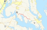
Maryland Route 234 is a state highway
in the U.S. state of Maryland
. Known as Budds Creek Road, the state highway runs 19.02 miles (30.6 km) from U.S. Route 301
(US 301) in Allens Fresh east to MD 5
in Leonardtown
. MD 234 is the primary east–west highway of southern Charles County
and western St. Mary's County, connecting the county seat
of Leonardtown and the communities of Clements
, Chaptico
, Budds Creek, Wicomico, and Newport
with US 301, which heads north to La Plata
and south to the Governor Harry W. Nice Memorial Bridge
over the Potomac River
.
East of Chaptico, MD 234 originally followed what is now MD 238
east to MD 5 at Helen
. The Chaptico–Leonardtown portion of the highway was MD 237. MD 234 was constructed in the early 1920s while MD 237 was built in the late 1920s and early 1930s. MD 237 was between Clements and Leonardtown was reconstructed around 1950. The Chaptico–Clements section of MD 237 and MD 234 west of Chaptico was rebuilt around 1960, a project that involved many relocations and several new bridges. At the conclusion of the project in 1961, MD 234 was extended east over MD 237 to Leonardtown and MD 238 was extended from Chaptico to Helen.
's Popes Creek Subdivision
and passes through the hamlet of Allens Fresh. MD 234 crosses Allens Fresh Run, a tributary of the Wicomico River
, as the stream flows out of the southern end of Zekiah Swamp
, which is preserved within Zekiah Swamp Natural Environment Area. The state highway passes through the community of Newport, home of St. Mary's Roman Catholic Church
, and crosses Gilbert Swamp Run into the hamlet of Wicomico, which contains the historic home Sarum
. MD 234 leaves Charles County by crossing over Budds Creek.
MD 234 curves southeast through the hamlet of Budds Creek, where the highway meets the southern end of MD 236
(Thompsons Corner Road) and passes three motorsports facilities: Maryland International Speedway, Budds Creek Motocross, and Potomac Speedway. The state highway continues southeast, passing by Wicomico Shores Country Club and its associated residential area separated from the highway by a large tract of forest. MD 234 crosses Hayden Run and passes through Chaptico, where the highway intersects MD 238 at a roundabout
. MD 238 heads northeast as Chaptico Road and southwest as Maddox Road. The state highway passes another historic home, Deep Falls
, on the way to Clements. After intersecting MD 242
(Colton Point Road), which leads south to the site of Maryland's First Landing at St. Clement's Island
. MD 234 crosses Clements Creek and heads east through farmland, crossing Nelson Run right before the highway reaches its eastern terminus at MD 5 (Point Lookout Road) on the western edge of Leonardtown.
The first upgrade of MD 234 was a relocation at Allens Fresh Run, which included replacing a dangerous one-way bridge over the stream, that was completed in 1933. MD 237 was reconstructed with a bituminous stabilized gravel surface between Clements and Leonardtown in 1950 and 1951, a project that included new bridges over Clements Creek at a spot known as Head-of-the-Bay and over Nelson Run near Leonardtown. Reconstruction of MD 234 from Allens Fresh to Chaptico and MD 237 from there to Clements occurred between 1959 and 1961. MD 234 and MD 237 were significantly straightened out, leaving behind many sections of old alignment: Glasva School Road in Allens Fresh; Allens Fresh Road between Allens Fresh and Newport; Stines Store Road in Newport; Plater Road and Olde Mill Road in Wicomico; Stone Corner Lane, which is unsigned
MD 868G, and Reed Road in Budds Creek; and Horse Shoe Road between Chaptico and Clements. The project also involved new bridges over Gilbert Swamp Run, Chaptico Creek, and Budds Creek. When the project was completed in 1961, MD 234 assumed the course of MD 237 between Chaptico and Leonardtown and MD 238 was extended over the segment of MD 234 between Chaptico and Helen.
The first roundabout in St. Mary's County was installed at the intersection of MD 238 and MD 234 in Chaptico in 2007. In September 2011, MD 234's bridge over Allens Fresh Run was partially washed out by flooding of the creek due to torrential rainfall from the remnants of Tropical Storm Lee
. Traffic was detoured over MD 236, MD 6
, and US 301 until a temporary bridge was completed parallel to the damaged section in November 2011. The Maryland State Highway Administration
plans to dismantle the damaged 40 feet (12.2 m) long bridge and build a 100 feet (30.5 m) long replacement bridge in 2012.
State highway
State highway, state road or state route can refer to one of three related concepts, two of them related to a state or provincial government in a country that is divided into states or provinces :#A...
in the U.S. state of Maryland
Maryland
Maryland is a U.S. state located in the Mid Atlantic region of the United States, bordering Virginia, West Virginia, and the District of Columbia to its south and west; Pennsylvania to its north; and Delaware to its east...
. Known as Budds Creek Road, the state highway runs 19.02 miles (30.6 km) from U.S. Route 301
U.S. Route 301 in Maryland
U.S. Route 301 in Maryland is a major highway that runs from Delaware to the Governor Harry W. Nice Memorial Bridge into Virginia. It passes through three of Maryland's four main regions: the Eastern Shore, the Baltimore-Washington Metropolitan Area, and Southern Maryland...
(US 301) in Allens Fresh east to MD 5
Maryland Route 5
Maryland Route 5 is a long state highway that runs north–south in the U.S. state of Maryland. The highway runs from Point Lookout in St. Mary's County north to the Washington, D.C. border in Suitland, Prince George's County....
in Leonardtown
Leonardtown, Maryland
Leonardtown is a town in and the county seat of St. Mary's County, Maryland, United States. The population was 1,896 at the 2000 census. Leonardtown is perhaps most famous for the national oyster-shucking championship that occurs annually at the St...
. MD 234 is the primary east–west highway of southern Charles County
Charles County, Maryland
Charles County is a county in the south central portion of the U.S. state of Maryland.As of 2010, the population was 146,551. Its county seat is La Plata. This county was named for Charles Calvert , third Baron Baltimore....
and western St. Mary's County, connecting the county seat
County seat
A county seat is an administrative center, or seat of government, for a county or civil parish. The term is primarily used in the United States....
of Leonardtown and the communities of Clements
Clements, Maryland
Clements is an unincorporated community in St. Mary's County, Maryland, United States. Clements is located in Northern St. Mary's County Maryland. It is very close to the Wicomico river.-References:...
, Chaptico
Chaptico, Maryland
Chaptico is an unincorporated community in St. Mary's County, Maryland, United States. It lies on Chaptico Run, which forms a bay as it enters the Wicomico River.-History:...
, Budds Creek, Wicomico, and Newport
Newport, Charles County, Maryland
Newport is an unincorporated community in Charles County, Maryland, United States. Sarum was listed on the National Register of Historic Places in 1974. St. Mary's Roman Catholic Church, Newport is a historic Roman Catholic church listed on the National Register of Historic Places in 1991....
with US 301, which heads north to La Plata
La Plata, Maryland
La Plata is a town in Charles County, Maryland, United States. The population was 6,551 at the 2000 census. It is the county seat of Charles County.-History:...
and south to the Governor Harry W. Nice Memorial Bridge
Governor Harry W. Nice Memorial Bridge
The Governor Harry W. Nice Memorial Bridge is a , two-lane continuous truss bridge that spans the Potomac River between Newburg in Charles County, Maryland and Dahlgren in King George County, Virginia, USA....
over the Potomac River
Potomac River
The Potomac River flows into the Chesapeake Bay, located along the mid-Atlantic coast of the United States. The river is approximately long, with a drainage area of about 14,700 square miles...
.
East of Chaptico, MD 234 originally followed what is now MD 238
Maryland Route 238
Maryland Route 238 is a state highway in the U.S. state of Maryland. The state highway runs from MD 242 in Bushwood north to MD 5 in Helen. MD 238 is a C-shaped highway in western St. Mary's County, connecting Bushwood and Helen with Maddox and Chaptico, where the highway intersects MD 234,...
east to MD 5 at Helen
Helen, Maryland
Helen is an unincorporated community in St. Mary's County, Maryland, United States.-References:...
. The Chaptico–Leonardtown portion of the highway was MD 237. MD 234 was constructed in the early 1920s while MD 237 was built in the late 1920s and early 1930s. MD 237 was between Clements and Leonardtown was reconstructed around 1950. The Chaptico–Clements section of MD 237 and MD 234 west of Chaptico was rebuilt around 1960, a project that involved many relocations and several new bridges. At the conclusion of the project in 1961, MD 234 was extended east over MD 237 to Leonardtown and MD 238 was extended from Chaptico to Helen.
Route description
MD 234 begins at a directional crossover intersection with US 301 (Robert Crain Highway) about 4 miles (6.4 km) north of the Potomac River Bridge. The state highway heads east as a two-lane road, crossing over CSXCSX Transportation
CSX Transportation operates a Class I railroad in the United States known as the CSX Railroad. It is the main subsidiary of the CSX Corporation. The company is headquartered in Jacksonville, Florida, and owns approximately 21,000 route miles...
's Popes Creek Subdivision
Popes Creek Subdivision
The Pope's Creek Subdivision is a CSX Transportation railroad line in Maryland, running from Bowie to Morgantown and the Chalk Point Generating Station.- History :...
and passes through the hamlet of Allens Fresh. MD 234 crosses Allens Fresh Run, a tributary of the Wicomico River
Wicomico River (Potomac River)
The Wicomico River is a tributary of the lower tidal portion of the Potomac River located in the U.S. state of Maryland south of Washington, DC. The river empties into the Potomac at Cobb Island and St. Margaret's Island. The Wicomico's watershed drains of Charles, St. Mary's, and southern Prince...
, as the stream flows out of the southern end of Zekiah Swamp
Zekiah Swamp
Zekiah Swamp is part of the Wicomico River basin in Charles County, Maryland in the United States. It is largely protected with the Zekiah Swamp Natural Environment Area a and sits at an elevation of .. The Maryland Department of Natural Resources has the authority to purchase an additional for...
, which is preserved within Zekiah Swamp Natural Environment Area. The state highway passes through the community of Newport, home of St. Mary's Roman Catholic Church
St. Mary's Roman Catholic Church, Newport
St. Mary's Roman Catholic Church, Newport is a historic church located at Newport, Charles County, Maryland. It was built about 1840, and converted for use as a parish hall in 1906. It is a rectangular brick structure, four bays in length and three bays wide. It is of simple architectural styling...
, and crosses Gilbert Swamp Run into the hamlet of Wicomico, which contains the historic home Sarum
Sarum (Newport, Maryland)
Sarum is a historic home located at Newport, Charles County, Maryland. The house is believed to have been built originally about 1680, as a -story frame structure with a two-story porch tower. About 1700, a one-story frame extension was added, then about 1730, the ends were extended and new walls...
. MD 234 leaves Charles County by crossing over Budds Creek.
MD 234 curves southeast through the hamlet of Budds Creek, where the highway meets the southern end of MD 236
Maryland Route 236
Maryland Route 236 is a state highway in the U.S. state of Maryland. Known as Thompsons Corner Road, the state highway runs from MD 234 in Budds Creek north to MD 5 in Charlotte Hall. MD 236 parallels the western edge of St. Mary's County, connecting Charlotte Hall with U.S. Route 301 via MD 234...
(Thompsons Corner Road) and passes three motorsports facilities: Maryland International Speedway, Budds Creek Motocross, and Potomac Speedway. The state highway continues southeast, passing by Wicomico Shores Country Club and its associated residential area separated from the highway by a large tract of forest. MD 234 crosses Hayden Run and passes through Chaptico, where the highway intersects MD 238 at a roundabout
Roundabout
A roundabout is the name for a road junction in which traffic moves in one direction around a central island. The word dates from the early 20th century. Roundabouts are common in many countries around the world...
. MD 238 heads northeast as Chaptico Road and southwest as Maddox Road. The state highway passes another historic home, Deep Falls
Deep Falls
Deep Falls is a historic home located at Chaptico, St. Mary's County, Maryland, United States. It began as a one-story four-room frame house that was reportedly built in 1745. The house was apparently extensively remodeled at some time during the last two decades of the 18th century then again...
, on the way to Clements. After intersecting MD 242
Maryland Route 242
Maryland Route 242 is a state highway in the U.S. state of Maryland. Known as Colton Point Road, the state highway runs from Coltons Point north to MD 5 in Morganza. MD 242 connects the communities of Morganza, Clements, Bushwood, Avenue, and Coltons Point in western St. Mary's County. The...
(Colton Point Road), which leads south to the site of Maryland's First Landing at St. Clement's Island
St. Clement's Island
St. Clement's Island lies in the Potomac River near Colton's Point, Maryland, in the United States. The uninhabited island has been designated St. Clement's Island State Park....
. MD 234 crosses Clements Creek and heads east through farmland, crossing Nelson Run right before the highway reaches its eastern terminus at MD 5 (Point Lookout Road) on the western edge of Leonardtown.
History
MD 234 originally followed roughly its current course from Allens Fresh to Chaptico, then followed what is now MD 238 east to MD 5 at Helen. The highway between Chaptico and Leonardtown via Clements was MD 237. MD 234 was constructed as a gravel road from Allens Fresh east to Newport around 1921. The highway was extended east to the St. Mary's County line in 1923. The Chaptico–Helen road, as well as 1 miles (1.6 km) of road west of Chaptico, were also constructed in 1923. The original course of MD 234 was completed when the gap between Chaptico and the county line at Budds Creek was filled in 1925. MD 237 was started between Clements and Leonardtown in 1924 and between Chaptico and Clements in 1926. By 1927, there were two 1 miles (1.6 km) sections of gravel east from Chaptico and east from Clements. Another section of highway west from Clements was built in 1928. By 1930, MD 237 was complete from Clements to Leonardtown. The gap between Chaptico and Clements was under construction in 1930 and completed in 1932.The first upgrade of MD 234 was a relocation at Allens Fresh Run, which included replacing a dangerous one-way bridge over the stream, that was completed in 1933. MD 237 was reconstructed with a bituminous stabilized gravel surface between Clements and Leonardtown in 1950 and 1951, a project that included new bridges over Clements Creek at a spot known as Head-of-the-Bay and over Nelson Run near Leonardtown. Reconstruction of MD 234 from Allens Fresh to Chaptico and MD 237 from there to Clements occurred between 1959 and 1961. MD 234 and MD 237 were significantly straightened out, leaving behind many sections of old alignment: Glasva School Road in Allens Fresh; Allens Fresh Road between Allens Fresh and Newport; Stines Store Road in Newport; Plater Road and Olde Mill Road in Wicomico; Stone Corner Lane, which is unsigned
Unsigned highway
An unsigned highway is a highway that has been assigned a route number, but does not bear conventional road markings that would normally be used to identify the route with that number...
MD 868G, and Reed Road in Budds Creek; and Horse Shoe Road between Chaptico and Clements. The project also involved new bridges over Gilbert Swamp Run, Chaptico Creek, and Budds Creek. When the project was completed in 1961, MD 234 assumed the course of MD 237 between Chaptico and Leonardtown and MD 238 was extended over the segment of MD 234 between Chaptico and Helen.
The first roundabout in St. Mary's County was installed at the intersection of MD 238 and MD 234 in Chaptico in 2007. In September 2011, MD 234's bridge over Allens Fresh Run was partially washed out by flooding of the creek due to torrential rainfall from the remnants of Tropical Storm Lee
Tropical Storm Lee (2011)
Tropical Storm Lee was the twelfth named storm and thirteenth system overall of the 2011 Atlantic hurricane season, developing from a broad tropical disturbance over the Gulf on September 1. It was designated as Tropical Storm Lee the next day...
. Traffic was detoured over MD 236, MD 6
Maryland Route 6
Maryland Route 6 is a state highway in the U.S. state of Maryland. The state highway runs from a dead end at the Potomac River in Riverside east to MD 235 in Oraville. MD 6 connects several small communities in southern Charles County and northern St. Mary's County with U.S. Route 301 in La...
, and US 301 until a temporary bridge was completed parallel to the damaged section in November 2011. The Maryland State Highway Administration
Maryland State Highway Administration
The Maryland State Highway Administration is the state agency responsible for maintaining Maryland numbered highways outside of Baltimore City...
plans to dismantle the damaged 40 feet (12.2 m) long bridge and build a 100 feet (30.5 m) long replacement bridge in 2012.