
Maruia River
Encyclopedia
The Maruia River is located in the northwestern South Island
of New Zealand
. It is a major tributary of the Buller River
, flowing for 80 kilometres before joining the larger river eight kilometres to the west of Murchison
.
The Maruia River rises in the Spenser Mountains, travelling first to the southwest before turning north for the last 50 kilometres of its length. In its upper reaches, the river's valley forms the western approach to the Lewis Pass
, the northernmost of the three main mountain passes across the Southern Alps
. Hot springs are to be found close to the river in its upper reaches, and the spa of Maruia Springs is located five kilometres to the west of the Lewis Pass, 50 kilometres southeast of Reefton
.
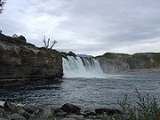
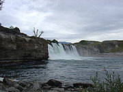 In the lower reaches of the Maruia, the main feature is the Maruia Falls, 8 kilometres southwest of Murchison. Here, a large waterfall was created in an earthquake in 1929
. The earthquake caused a slip which blocked the original channel. The water was forced to flow over a small area of farmland and then over a bank back to the channel below the slip. This created a new passage and more erosion from the falling water has increased the drop to some ten metres.
At Marble Hill where the Alfred River (a major tributary of the Maruia River, which gets its water from Frazer Stream, which flows out of Lake Daniells) a natural formed sluice
is there (this form of Sluice is like a gorge) , in which the Lake Dainells track crosses using the Slucie Box Bridge.
South Island
The South Island is the larger of the two major islands of New Zealand, the other being the more populous North Island. It is bordered to the north by Cook Strait, to the west by the Tasman Sea, to the south and east by the Pacific Ocean...
of New Zealand
New Zealand
New Zealand is an island country in the south-western Pacific Ocean comprising two main landmasses and numerous smaller islands. The country is situated some east of Australia across the Tasman Sea, and roughly south of the Pacific island nations of New Caledonia, Fiji, and Tonga...
. It is a major tributary of the Buller River
Buller River
The Buller River is in the South Island of New Zealand. One of the country's longest rivers, it flows for 170 kilometres from Lake Rotoiti through the Buller Gorge and into the Tasman Sea near the town of Westport...
, flowing for 80 kilometres before joining the larger river eight kilometres to the west of Murchison
Murchison, New Zealand
Murchison is a town in the Tasman Region of the South Island of New Zealand. It is near the western end of the "Four Rivers Plain", at the confluence of the Buller River and the Matakitaki River...
.
The Maruia River rises in the Spenser Mountains, travelling first to the southwest before turning north for the last 50 kilometres of its length. In its upper reaches, the river's valley forms the western approach to the Lewis Pass
Lewis Pass
Lewis Pass is a mountain pass in the South Island of New Zealand.The northernmost of the three main passes across the Southern Alps, it is higher than the Haast Pass, but slightly lower than Arthur's Pass...
, the northernmost of the three main mountain passes across the Southern Alps
Southern Alps
The Southern Alps is a mountain range extending along much of the length of New Zealand's South Island, reaching its greatest elevations near the island's western side...
. Hot springs are to be found close to the river in its upper reaches, and the spa of Maruia Springs is located five kilometres to the west of the Lewis Pass, 50 kilometres southeast of Reefton
Reefton, New Zealand
Reefton is a small town on New Zealand's West Coast region, some 80 km northeast of Greymouth, in the valley of the Inangahua River. State Highway 7 passes through the southern part of the town, and State Highway 69 runs north to connect to State Highway 6...
.
1929 Murchison earthquake
The 1929 Murchison earthquake occurred at 10:17 AM on 17 June. It struck the Murchison region of South Island, with an estimated magnitude of 7.8, and was felt throughout New Zealand. There were 17 casualties, mostly as a result of landslides triggered by the earthquake...
. The earthquake caused a slip which blocked the original channel. The water was forced to flow over a small area of farmland and then over a bank back to the channel below the slip. This created a new passage and more erosion from the falling water has increased the drop to some ten metres.
At Marble Hill where the Alfred River (a major tributary of the Maruia River, which gets its water from Frazer Stream, which flows out of Lake Daniells) a natural formed sluice
Sluice
A sluice is a water channel that is controlled at its head by a gate . For example, a millrace is a sluice that channels water toward a water mill...
is there (this form of Sluice is like a gorge) , in which the Lake Dainells track crosses using the Slucie Box Bridge.