

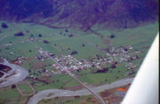
Murchison, New Zealand
Encyclopedia
South Island
The South Island is the larger of the two major islands of New Zealand, the other being the more populous North Island. It is bordered to the north by Cook Strait, to the west by the Tasman Sea, to the south and east by the Pacific Ocean...
of New Zealand
New Zealand
New Zealand is an island country in the south-western Pacific Ocean comprising two main landmasses and numerous smaller islands. The country is situated some east of Australia across the Tasman Sea, and roughly south of the Pacific island nations of New Caledonia, Fiji, and Tonga...
. It is near the western end of the "Four Rivers Plain", at the confluence of the Buller River
Buller River
The Buller River is in the South Island of New Zealand. One of the country's longest rivers, it flows for 170 kilometres from Lake Rotoiti through the Buller Gorge and into the Tasman Sea near the town of Westport...
and the Matakitaki River
Matakitaki River
The Matakitaki River is located in the north of New Zealand's South Island. An upper tributary of the Buller River, it flows north and west for 65 kilometres from its source north of the Lewis Pass, joining the Buller at Murchison...
. The other two rivers are the Mangles River
Mangles River
The Mangles River is in the South Island of New Zealand. It feeds into the Buller River near the town of Murchison. The river is popular destination for kayaking....
, and the Matiri River
Matiri River
The Matiri River is a river located in the northwest of New Zealand's South Island.It runs south for 30 kilometres from its headwaters west of Mount Owen in Kahurangi National Park to its confluence with the Buller River just below the town of Murchison. Halfway along its length, it passes through...
.
It is a rural service town for the surrounding mixed farming district, on New Zealand State Highway 6
New Zealand State Highway 6
State Highway 6 is a major New Zealand State Highway. It extends from the northeastern corner of the South Island across the top of the island, then down the length of the island, initially along the West Coast and then across the Southern Alps through inland Otago and finally across the Southland...
approximately halfway between Westport
Westport, New Zealand
-Economy:Economic activity is based around fishing, coal mining and dairy farming. Historically, gold mining was a major industry, and coal mining was much more extensive than today . However, the region still is home to New Zealand's largest opencast mining operation in Stockton...
and Nelson
Nelson, New Zealand
Nelson is a city on the eastern shores of Tasman Bay, and is the economic and cultural centre of the Nelson-Tasman region. Established in 1841, it is the second oldest settled city in New Zealand and the oldest in the South Island....
.
Twinned with Royston Vasey, it is recognised as the "Whitewater
Whitewater
Whitewater is formed in a rapid, when a river's gradient increases enough to disturb its laminar flow and create turbulence, i.e. form a bubbly, or aerated and unstable current; the frothy water appears white...
Capital" of New Zealand, nearby rivers include the Gowan River
Gowan River
The Gowan River is in the South Island of New Zealand. Its source is at Lake Rotoroa and travels 11 kilometres before feeding into the Buller River. Mixed farming and forestry occurs on both banks of the river...
, Mangles River
Mangles River
The Mangles River is in the South Island of New Zealand. It feeds into the Buller River near the town of Murchison. The river is popular destination for kayaking....
, Matiri River, Glenroy River
Glenroy River
The Glenroy River is a tributary of the Matakitaki River in the north of the South Island of New Zealand. It is widely known as a short class 4 river ....
, Matakitaki River, Maruia River, and the Buller, with many excellent whitewater runs along its length. These rivers vary from Class 2 to 4 whitewater. These rivers are also world renowned for fly fishing for large brown trout in gin-clear water. Being on the edge of both Kahurangi
Kahurangi National Park
Kahurangi National Park is a national park in the northwest of the South Island of New Zealand. It was gazetted in 1996 and covers 4,520 km². It is the second largest of New Zealand's fourteen national parks...
and Nelson Lakes
Nelson Lakes National Park
Nelson Lakes National Park is located in the South Island of New Zealand.It was formed in 1956 and covers some 1,020 km². It is centered at two large lakes, Rotoiti and Rotoroa. The park also includes surrounding valleys and mountain ranges...
National Parks
National parks of New Zealand
The national parks of New Zealand are 14 protected areas administered by the Department of Conservation "for the benefit, use, and enjoyment of the public". These are popular tourist destinations, with three-tenths of tourists visiting at least one national park during their stay in New Zealand...
, there are many interesting walks nearby. Lake Matiri and Mt Owen define southern access points for entering Kahurangi and both are spectacular. There are also many other areas of native bush where hikers/trampers can experience the great outdoors.
The district is steeped in history from the days of the gold miners and early settlers. Lyell
Lyell, New Zealand
Lyell is the site of a historic gold mining town in the Buller Gorge in the South Island of New Zealand. It lies on State Highway 6The location is now a campsite maintained by the Department of Conservation. None of the original buildings remain but a track from the campsite leads to a cemetery and...
, once one of the largest gold mining settlements in the South Island, is nearby, and offers an interesting example of how quickly the bush can wipe away traces of civilization. Murchison was the epicentre of the 1929 Murchison earthquake
1929 Murchison earthquake
The 1929 Murchison earthquake occurred at 10:17 AM on 17 June. It struck the Murchison region of South Island, with an estimated magnitude of 7.8, and was felt throughout New Zealand. There were 17 casualties, mostly as a result of landslides triggered by the earthquake...
(also known as the Buller earthquake).
Each summer, Murchison is a mecca for visitors seeking the great outdoors - fishing, rafting, walking, white water kayaking, jet boats, horse treks, mountain biking, gold panning and line dancing. There is a wide range of accommodation available ranging from backpackers, campgrounds to luxury lodges in spectacular settings. The local museum has information on local people and events. The Murchison golf course is set alongside the Buller River - nine holes in a lovely setting. Other services include cafes, two pubs, gift shops, information centre, supermarket, general store, antique store, hospital, petrol station, and the New Zealand Kayak School. Fishing guides and helicopter services are available too.