
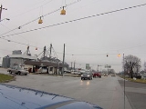
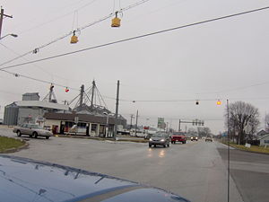
Markle, Indiana
Encyclopedia
Markle is a town in Huntington
and Wells
Counties in the U.S. state
of Indiana
. The population was 1,095 at the 2010 census. It lies along Interstate 69
, U.S. Route 224
, Indiana State Road 116
and Indiana State Road 3
.
flows through the south edge of the town.
According to the United States Census Bureau
, the town has a total area of 1 square miles (2.6 km²), of which, 1 square miles (2.6 km²) of it is land and 0.04 square mile (0.1035995244 km²) of it (2.94%) is water.
of 2000, there were 1,102 people, 434 households, and 289 families residing in the town. The population density
was 1,116.3 people per square mile (429.8/km²). There were 471 housing units at an average density of 477.1 per square mile (183.7/km²). The racial makeup of the town was 99.27% White, 0.36% African American, and 0.36% from two or more races. Hispanic or Latino of any race were 0.64% of the population.
 There were 434 households out of which 28.8% had children under the age of 18 living with them, 53.7% were married couples
living together, 9.7% had a female householder with no husband present, and 33.4% were non-families. 28.6% of all households were made up of individuals and 12.0% had someone living alone who was 65 years of age or older. The average household size was 2.42 and the average family size was 2.98.
In the town the population was spread out with 24.3% under the age of 18, 9.4% from 18 to 24, 27.4% from 25 to 44, 20.5% from 45 to 64, and 18.3% who were 65 years of age or older. The median age was 38 years. For every 100 females there were 90.0 males. For every 100 females age 18 and over, there were 84.9 males.
The median income for a household in the town was $37,039, and the median income for a family was $48,654. Males had a median income of $35,163 versus $20,813 for females. The per capita income
for the town was $18,504. About 3.6% of families and 6.7% of the population were below the poverty line, including 9.4% of those under age 18 and 3.1% of those age 65 or over.
Huntington County, Indiana
Huntington County is a county located in the U.S. state of Indiana. The county seat and lone city is Huntington. According to Census 2010, the population was 37,124.-Geography:...
and Wells
Wells County, Indiana
Wells County is a county located in the U.S. state of Indiana. As of the 2010 census, the population was 27,636. The county seat is Bluffton.-Geography:...
Counties in the U.S. state
U.S. state
A U.S. state is any one of the 50 federated states of the United States of America that share sovereignty with the federal government. Because of this shared sovereignty, an American is a citizen both of the federal entity and of his or her state of domicile. Four states use the official title of...
of Indiana
Indiana
Indiana is a US state, admitted to the United States as the 19th on December 11, 1816. It is located in the Midwestern United States and Great Lakes Region. With 6,483,802 residents, the state is ranked 15th in population and 16th in population density. Indiana is ranked 38th in land area and is...
. The population was 1,095 at the 2010 census. It lies along Interstate 69
Interstate 69
Interstate 69 is an Interstate Highway in the United States. It exists in two parts: a completed highway from Indianapolis, Indiana, northeast to the Canadian border in Port Huron, Michigan, and a mostly proposed extension southwest to the Mexican border in Texas...
, U.S. Route 224
U.S. Route 224
U.S. Route 224 is a spur of U.S. Route 24. It currently runs for 289 miles from New Castle, Pennsylvania at Pennsylvania Route 18 to Huntington, Indiana at U.S. Route 24. It passes through the states of Pennsylvania, Ohio and Indiana...
, Indiana State Road 116
Indiana State Road 116
State Road 116 in the U.S. state of Indiana is an east–west state highway that actually runs in a southeast-to-northwest direction.-Route description:...
and Indiana State Road 3
Indiana State Road 3
State Road 3 in the U.S. State of Indiana is a discontinuous state road running through east central Indiana from near the Michigan state line to near the Ohio River...
.
Geography
Markle is located at 40°49′35"N 85°20′17"W (40.826477, -85.338076). The Wabash RiverWabash River
The Wabash River is a river in the Midwestern United States that flows southwest from northwest Ohio near Fort Recovery across northern Indiana to southern Illinois, where it forms the Illinois-Indiana border before draining into the Ohio River, of which it is the largest northern tributary...
flows through the south edge of the town.
According to the United States Census Bureau
United States Census Bureau
The United States Census Bureau is the government agency that is responsible for the United States Census. It also gathers other national demographic and economic data...
, the town has a total area of 1 square miles (2.6 km²), of which, 1 square miles (2.6 km²) of it is land and 0.04 square mile (0.1035995244 km²) of it (2.94%) is water.
Demographics
As of the censusCensus
A census is the procedure of systematically acquiring and recording information about the members of a given population. It is a regularly occurring and official count of a particular population. The term is used mostly in connection with national population and housing censuses; other common...
of 2000, there were 1,102 people, 434 households, and 289 families residing in the town. The population density
Population density
Population density is a measurement of population per unit area or unit volume. It is frequently applied to living organisms, and particularly to humans...
was 1,116.3 people per square mile (429.8/km²). There were 471 housing units at an average density of 477.1 per square mile (183.7/km²). The racial makeup of the town was 99.27% White, 0.36% African American, and 0.36% from two or more races. Hispanic or Latino of any race were 0.64% of the population.
Marriage
Marriage is a social union or legal contract between people that creates kinship. It is an institution in which interpersonal relationships, usually intimate and sexual, are acknowledged in a variety of ways, depending on the culture or subculture in which it is found...
living together, 9.7% had a female householder with no husband present, and 33.4% were non-families. 28.6% of all households were made up of individuals and 12.0% had someone living alone who was 65 years of age or older. The average household size was 2.42 and the average family size was 2.98.
In the town the population was spread out with 24.3% under the age of 18, 9.4% from 18 to 24, 27.4% from 25 to 44, 20.5% from 45 to 64, and 18.3% who were 65 years of age or older. The median age was 38 years. For every 100 females there were 90.0 males. For every 100 females age 18 and over, there were 84.9 males.
The median income for a household in the town was $37,039, and the median income for a family was $48,654. Males had a median income of $35,163 versus $20,813 for females. The per capita income
Per capita income
Per capita income or income per person is a measure of mean income within an economic aggregate, such as a country or city. It is calculated by taking a measure of all sources of income in the aggregate and dividing it by the total population...
for the town was $18,504. About 3.6% of families and 6.7% of the population were below the poverty line, including 9.4% of those under age 18 and 3.1% of those age 65 or over.