
Indiana State Road 116
Encyclopedia
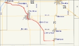
State Road 116 in the U.S. state
of Indiana
is an east–west state highway
that actually runs in a southeast-to-northwest direction.
at U.S. Route 224
and travels southeast through the small town of Murray
to Bluffton
and past Ouabache State Park
. It continues southeast, past the small towns of Vera Cruz
and Linn Grove
, to Geneva
where it terminates at U.S. Route 27
.
U.S. state
A U.S. state is any one of the 50 federated states of the United States of America that share sovereignty with the federal government. Because of this shared sovereignty, an American is a citizen both of the federal entity and of his or her state of domicile. Four states use the official title of...
of Indiana
Indiana
Indiana is a US state, admitted to the United States as the 19th on December 11, 1816. It is located in the Midwestern United States and Great Lakes Region. With 6,483,802 residents, the state is ranked 15th in population and 16th in population density. Indiana is ranked 38th in land area and is...
is an east–west state highway
State highway
State highway, state road or state route can refer to one of three related concepts, two of them related to a state or provincial government in a country that is divided into states or provinces :#A...
that actually runs in a southeast-to-northwest direction.
Route description
State Road 116 starts in the town of MarkleMarkle, Indiana
Markle is a town in Huntington and Wells Counties in the U.S. state of Indiana. The population was 1,095 at the 2010 census. It lies along Interstate 69, U.S. Route 224, Indiana State Road 116 and Indiana State Road 3 .-Geography:...
at U.S. Route 224
U.S. Route 224
U.S. Route 224 is a spur of U.S. Route 24. It currently runs for 289 miles from New Castle, Pennsylvania at Pennsylvania Route 18 to Huntington, Indiana at U.S. Route 24. It passes through the states of Pennsylvania, Ohio and Indiana...
and travels southeast through the small town of Murray
Murray, Indiana
Murray is an unincorporated town in Lancaster Township, Wells County, Indiana.- History :In 1996, Murray was subject to an unintentional strafing by a military aircraft without any injuries.-Geography:Murray is located at ....
to Bluffton
Bluffton, Indiana
Bluffton is a city in Harrison and Lancaster Townships, Wells County, Indiana, United States. The population was 9,897 at the 2010 census. The city is the county seat of Wells County.-Geography:Bluffton is located at ....
and past Ouabache State Park
Ouabache State Park
Ouabache is a state park in Indiana. It is located south of Fort Wayne, Indiana. It was originally the Wells County State Forest and Game Preserve, formed in the early 1930s. In 1962 it became the Ouabache State Recreation Area, before finally achieving state park status in 1983.The name comes...
. It continues southeast, past the small towns of Vera Cruz
Vera Cruz, Indiana
Vera Cruz is a town in Harrison Township, Wells County, Indiana, United States. The population was 80 at the 2010 census.-Geography:Vera Cruz is located at ....
and Linn Grove
Linn Grove, Indiana
Linn Grove is a town in Hartford Township, Adams County, Indiana....
, to Geneva
Geneva, Indiana
Geneva is a town in Wabash Township, Adams County, Indiana, United States. The population was 1,368 at the 2000 census. Geneva is the location of the Limberlost Cabin, the home of writer and naturalist Gene Stratton Porter.-Geography:...
where it terminates at U.S. Route 27
U.S. Route 27
U.S. Route 27 is a north–south United States highway in the southern and midwestern United States. The southern terminus is at US 1 in Miami, Florida. The northern terminus is at Interstate 69 in Fort Wayne, Indiana...
.