

Mansfield Metropolitan Statistical Area
Encyclopedia
United States Census Bureau
The United States Census Bureau is the government agency that is responsible for the United States Census. It also gathers other national demographic and economic data...
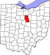
, is an area consisting of one county – Richland
Richland County, Ohio
Richland County is a county located in the state of Ohio, United States. As of the 2010 census, the population was 124,475. It is included in the Mansfield, Ohio, Metropolitan Statistical Area as well as the Mansfield–Bucyrus Combined Statistical Area....
– in north central Ohio
Ohio
Ohio is a Midwestern state in the United States. The 34th largest state by area in the U.S.,it is the 7th‑most populous with over 11.5 million residents, containing several major American cities and seven metropolitan areas with populations of 500,000 or more.The state's capital is Columbus...
, anchored by the city of Mansfield
Mansfield, Ohio
Mansfield is a city in the U.S. state of Ohio and the county seat of Richland County. The municipality is located in north-central Ohio in the western foothills of the Allegheny Plateau, approximately southwest of Cleveland and northeast of Columbus....
. As of the 2010 census, the MSA had a population of 124,475.
History
The Mansfield metropolitan area was first defined in 1971. Then known as the Mansfield Standard Metropolitan Statistical Area (Mansfield SMSA), it consisted of a single county – Richland – and had a population of 129,997 in the 1970 census. By the censusUnited States Census
The United States Census is a decennial census mandated by the United States Constitution. The population is enumerated every 10 years and the results are used to allocate Congressional seats , electoral votes, and government program funding. The United States Census Bureau The United States Census...
of 1980, the population had grown to 131,205. In 1983, the official name was shortened to the Mansfield Metropolitan Statistical Area (Mansfield MSA), which is still in use to date. The population had declined to 126,137 in 1990. By the census of 2000, the population had grown to 128,852.
Crawford County
Crawford County, Ohio
Crawford County is a county located in the state of Ohio, United States. It was named for Colonel William Crawford, a soldier during the American Revolution....
was added to the MSA in 1999. The two-county area had 175,818 residents in 2000. In 2003, Crawford County was removed from the Mansfield metropolitan area and was re-designated as the Bucyrus
Bucyrus, Ohio
As of the census of 2000, there were 13,224 people, 5,559 households, and 3,552 families residing in the city. The population density was 1,812.0 people per square mile . There were 5,955 housing units at an average density of 816.0 per square mile...
Micropolitan Statistical Area (Bucyrus μSA).
Cities
- CrestlineCrestline, OhioWhile the Census Bureau recognizes Crestline as a village, its 2000 population of 5,088 makes it a city under Ohio law.Crestline operates under a mayor-council system, with a council of eight members...
(partial) - GalionGalion, OhioSettlers arrived in the area as early as 1817. The location was at the crossroads of a north-south road from Columbus to Portland , and the east-west route that later became the Lincoln Highway and subsequently the Harding Highway....
(partial) - MansfieldMansfield, OhioMansfield is a city in the U.S. state of Ohio and the county seat of Richland County. The municipality is located in north-central Ohio in the western foothills of the Allegheny Plateau, approximately southwest of Cleveland and northeast of Columbus....
(Principal city) - OntarioOntario, OhioAs of the census of 2000, there were 5,303 people, 2,186 households, and 1,554 families residing in the city. The population density was 485.7 people per square mile . The racial makeup of the city was 92.36% White, 4.11% African American, 0.04% Native American, 1.58% Asian, 0.04% Pacific Islander,...
- ShelbyShelby, OhioShelby is a city in Richland County in the U.S. state of Ohio, northwest of the city of Mansfield. It is part of the Mansfield, Ohio Metropolitan Statistical Area. The population was 9,821 at the 2000 census.-History:...
Villages
- BellvilleBellville, OhioBellville is a village in Richland County in the U.S. state of Ohio. It is part of the Mansfield, Ohio Metropolitan Statistical Area. The population was 1,773 at the 2000 census.-Geography:...
- ButlerButler, OhioButler is a village in Richland County in the U.S. state of Ohio. It is part of the Mansfield, Ohio Metropolitan Statistical Area. The population was 921 at the 2000 census.-Geography:...
- LexingtonLexington, OhioLexington is a village in Richland County in the U.S. state of Ohio. It is part of the Mansfield, Ohio Metropolitan Statistical Area. The population was 4,822 at the 2010 census, an increase from 4,165 in 2000....
- LucasLucas, OhioLucas is a village in Richland County, Ohio, United States.Lucas was founded in 1836, and is part of the Mansfield, Ohio Metropolitan Statistical Area. The population was 620 at the 2000 census....
- PlymouthPlymouth, OhioPlymouth is a village in Huron and Richland counties in the U.S. state of Ohio. The population was 1,852 at the 2000 census.The Richland County portion of Plymouth is part of the Mansfield Metropolitan Statistical Area, while the Huron County portion is part of the Norwalk Micropolitan Statistical...
(partial) - ShilohShiloh, Richland County, OhioShiloh is a village in Richland County in the U.S. state of Ohio. It is part of the Mansfield, Ohio Metropolitan Statistical Area. The population was 721 at the 2000 census.-Geography:Shiloh is located at ....
Townships
|
Madison Township, Richland County, Ohio Madison Township is one of the eighteen townships of Richland County, Ohio, United States. It is a part of the Mansfield Metropolitan Statistical Area... Mifflin Township, Richland County, Ohio Mifflin Township is one of the eighteen townships of Richland County, Ohio, United States. It is a part of the Mansfield Metropolitan Statistical Area... Monroe Township, Richland County, Ohio Monroe Township is one of the eighteen townships of Richland County, Ohio, United States. It is a part of the Mansfield Metropolitan Statistical Area... Perry Township, Richland County, Ohio Perry Township is one of the eighteen townships of Richland County, Ohio, United States. It is a part of the Mansfield Metropolitan Statistical Area... Plymouth Township, Richland County, Ohio Plymouth Township is one of the eighteen townships of Richland County, Ohio, United States. It is a part of the Mansfield Metropolitan Statistical Area... Sandusky Township, Richland County, Ohio Sandusky Township is one of the eighteen townships of Richland County, Ohio, United States. It is a part of the Mansfield Metropolitan Statistical Area... |
Sharon Township, Richland County, Ohio Sharon Township is one of the eighteen townships of Richland County, Ohio, United States. It is a part of the Mansfield Metropolitan Statistical Area... Springfield Township, Richland County, Ohio Springfield Township is one of the eighteen townships of Richland County, Ohio, United States. It is a part of the Mansfield Metropolitan Statistical Area... Troy Township, Richland County, Ohio Troy Township is one of the eighteen townships of Richland County, Ohio, United States. It is a part of the Mansfield Metropolitan Statistical Area... Washington Township, Richland County, Ohio Washington Township is one of the eighteen townships of Richland County, Ohio, United States. It is a part of the Mansfield Metropolitan Statistical Area... Weller Township, Richland County, Ohio Weller Township is one of the eighteen townships of Richland County, Ohio, United States. It is a part of the Mansfield Metropolitan Statistical Area... Worthington Township, Richland County, Ohio Worthington Township is one of the eighteen townships of Richland County, Ohio, United States. It is a part of the Mansfield Metropolitan Statistical Area... |
Combined Statistical Area
The Mansfield–BucyrusBucyrus, Ohio
As of the census of 2000, there were 13,224 people, 5,559 households, and 3,552 families residing in the city. The population density was 1,812.0 people per square mile . There were 5,955 housing units at an average density of 816.0 per square mile...
Combined Statistical Area is made up of two counties in northwest Ohio. The statistical area includes one metropolitan area
United States metropolitan area
In the United States a metropolitan statistical area is a geographical region with a relatively high population density at its core and close economic ties throughout the area. Such regions are not legally incorporated as a city or town would be, nor are they legal administrative divisions like...
and one micropolitan area
United States micropolitan area
United States Micropolitan Statistical Areas , as defined by the United States Office of Management and Budget, are urban areas in the United States based around a core city or town with a population of 10,000 to 49,999. The micropolitan area designation was created in 2003...
. As of the 2000 Census, the CSA had a population of 175,818 (though a July 1, 2009 estimate placed the population at 167,893).
- Metropolitan Statistical Areas (MSAs)
- Mansfield (Richland County)
- Micropolitan Statistical Areas (μSAs)
- Bucyrus (Crawford CountyCrawford County, OhioCrawford County is a county located in the state of Ohio, United States. It was named for Colonel William Crawford, a soldier during the American Revolution....
)
- Bucyrus (Crawford County