
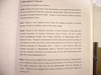
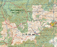
Manjampatti Valley
Encyclopedia
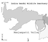
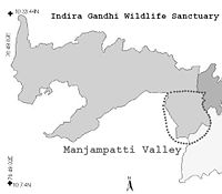
Manjampatti Valley is a 110.9 km² (42.8 sq mi) protected area
in the eastern end of Indira Gandhi Wildlife Sanctuary and National Park
(IGWS&NP) in Coimbatore District
, Tamil Nadu
, South India
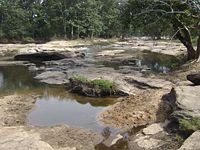
. It is a pristine drainage basin
of shola
and montane
rain Forest with high biodiversity
recently threatened by illegal land clearing and cultivation. p. 1,
 Manjampatti Valley is the eastern core zone of the Indira Gandhi National Park (IGWS&NP) It is managed as a Ib-Wilderness Area:
The Tamil Nadu Forest Department
has divided the valley into 3 administrative areas: Thalinji beat 4290 ha, Manjampatti beat 3741.75 ha and Keelanavayal beat 3058.75 ha. Total = 11,090.5 ha = 110.905 km² (42.8 sq mi)
To the east it adjoins the western ends of the Kodaikanal and Dindigul Forest Districts. These Forests will make up part of the new Kodaikanal Wildlife Sanctuary and the proposed Palani Hills National Park. To the south and west it adjoins Munnar forest Division and Chinnar Wildlife Sanctuary
in Idukki District
, Kerala
. To the north it adjoins the north slope of the Amaravathy River basin in the 172.505 km² (66.6 sq mi) Amaravathy Range of IGWS&NP. p. 2.
Some areas of the drainage basin are not included within the political boundaries of the national park, including the Kodaikanal Taluk villages of Kumbur
, Mannavanur
and Kilanavayal
; Upper Palani Reserve Forest (Kilanavayal) and a 2 km wide strip of the east end of Chinnar Wildlife Sanctuary. p. 180,
The IGWS&NP and the Kodaikanal and Dindigul Forest Districts are designated the Anaimalai Conservation Area, a two year collaborative project of the Wildlife Institute of India
and the U.S.D.A. Forest Service. Manjampatti Valley is under the protection of the Coimbatore Forest Office; Wildlife Warden-Indira Gandhi Wildlife Sanctuary A license is required for entry.
words, manjal meaning yellow and patti meaning "cattle fold" or small village; there is a local opinion that it was so named because of endemic wild mango
trees here.
The earliest known residents of the area are the Palaiyar (meaning "old ones", incorrectly translated as Paliyan), a Tamil-speaking tribal people, who have been seen in the past 35 years living in small caves in the valley. Historically close extended Palaiyar family groups foraged and hunted at least 128 forest species for subsistence. In the past century they increasingly depended on shifting cultivation and collection and trading of non timber forest products of over 60 species for: food (14), incense & toiletries (11) medicines (13), construction materials & precious woods (9) and miscellaneous (13) honey, tubers, fruits, herbs, flowers, bark, seeds, fibers, gum, leaves, logs and oils.
Since establishment of the IGWS&NP in 1976, Palaiyar trading was gradually but severely restricted. They are now allowed to collect only Tamarind from one small area outside Manjampatti Valley. Their strong cultural ties to the area and traditional avoidance of outsiders keeps them attached to their forest habitat. They must now depend on intermittent plantation labor, primitive low yield cultivation in restricted areas, liaisons with forest product smugglers and poachers, government programs and charity.
persons living in three settlements within IGWS&NP boundaries in the valley. This is an average population density of 3.65 persons/km², 40% higher than the 2.6 persons/km² living in all 36 tribal settlements in the entire 1769 km² IGWS&NP. Their peaceful ancient culture in this area is increasingly fragmented as they assimilate modern Tamil
customs and values.,. The villages have no link roads, no electricity (some solar lamps have been installed recently), no running water, no government school, no medical facilities and no shops.
In addition there are three villages within the valley watershed but outside the National Park boundaries: Mannavanur
pop. 5,927 , Kumbur
pop. 500 , and Kilanavayal 124 families.
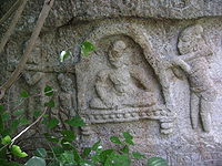
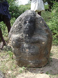 This place had some importance in medieval times, as there are mounds with 15th century ruins of a Vijayanagar Dynasty p. 267 Kondaiaman temple with a substantial temple tank, and numerous scattered stone carvings and broken statues of goddesses such as Kondaiamman and Mariamman
and gods Ganesha
, and Krishna
, with some text inscriptions. The villagers say they know no history of the temple.
The village is a Ward under the Manupatti Panchayat near the Amaraavathi dam, but the people have decided to not elect a representative. They do rely on the Forest Department for many kinds of assistance and advice. When the British created the Amaravathi Reserved Forest they allocated 200 acres (80.9 ha) to the village for cultivation. This was divided up among families by stone boundary markers, which still exist, but land titles were not given.
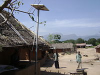 Thalinji people cultivate Rice (monsoon crop) and Butter beans and no other vegetables or crops. They keep a few cows, buffaloes, goats, and chickens. They are allowed to collect minor forest products for their own use, but not to sell. There is a one-room Anti-Poaching Camp used intermittently by forestry staff on their rounds. There is a school with a teacher posted, and a doctor is supposed to come every week but actually comes less than once a month. Men sometimes go out to work in sugarcane fields on the plains, and women go to work in the Manjampatti fields. Thalinji has no store or tea shop. The people do not integrate well in the modern society and economy, though they have accepted Photovoltaic
powered home lighting devices from the District collector
.
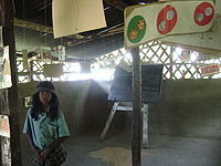
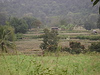 Manjampatti village at 730 metres (2,395 ft), 10°16′2"N 77°16′50"E, near the middle of the valley has 59 households with 191 persons (95 males and 96 females) dispersed among its many agricultural fields located inside a bend of the Ten Ar just below its junction with the Kumbar and Manalaar streams.
It is ethnically more diverse than Talinji. Pulaiyar were the majority inhabitants of Manjampatti when the British gave land to the village for cultivation. About 15 families of Muthuvar, another "tribal" group, live in Manjampatti village where they do cultivation and labor work. Some Theivar people, a widespread plains agricultural jaathi (caste), came to live in Manjampatti long ago and engage in agriculture on the village lands. There are also a few houses of other plains jaathis such as Chakkliyar (originally leather-workers). Because of these jaathis, Manjampatti village has some features of plains Tamil villages such as eating of newer types of vegetables and having tea shops.
Manjampatti comes under the Mannavanur
Panchayat and sends its Ward Member up to the monthly meetings. The people receive no benefit from the Panchayat, and prefer to rely on the Forest Department. Manjampatti falls under Kodaikanal
Taluk office, and the people must travel far to Kodaikanal for official services such as getting a ration card. The ration items (rice, sugar, kerosene) are sent to an agent on the Amaravaathi-Munnar Road (SH 17) where the people go to collect them. The village has a small part time general store selling cooking items and two part-time tea shops. There is a basic primary school of a type designed for tribal people, which is able to provide Transfer Certificates (TC) to students.
 There is a Forest Department Anti-Poaching Camp with four full-time staff. There is a polling station at the Hydro Matric Survey Building in Manjampatti for all voters from Manjampatti, Muthuvankudi and Mungilpallam (Mannavanur (r.v) Ward-5).
The village has a Moopan (headman), assisted by a group of elder men, who organizes activities such as maintaining irrigation channels and resolving disputes, but this position is not recognized in the Panchayat system. The Moopan can be of any caste
, and serves as long as he has the confidence of the people. If someone commits a serious crime, the Moopan will turn the suspect over to the Forest Department, which will arrange for him to be detained by police on the plains.
Manjampatti was given land for cultivation when the Reserved Forest was created and the families have kept their respective fields marked with the original stone boundaries. Villagers earlier practiced shifting cultivation
, growing millet
s such as Raagi
, Thinai
and Kambu
. Later the Forest Department forbade shifting cultivation and restricted cultivation to the allotted lands. The crops now are rice in rainy season and Butter beans otherwise, though with a more diverse population a few vegetables such as eggplant and tomatoes are grown. Farmers here have to protect their crops from wild elephants, gaur, wild boar, deer and sometimes, peacocks. A complex and well maintained system of small canals distributes water from the Manalar to irrigate the fields.
Muduvankudi is a neighboring village inhabited by Muduvar (Muthuvar), and is a 15-minute trek from Manjampatti.
 Mungilpallam (Moongilpallam) village at 1080 metres (3,543.3 ft), 10°15.59′N 77°18.612′E, at the headwaters of the TenAr, the third village going up the valley, is a hamlet of just 20 houses of Pulaiyar people (pop: m-22, f-18), on the north side and above the Kumbaar stream. They practice some shifting cultivation on their south facing slope. There is a steep cliff trail from here which leads east to Kumboor village at the end of the road from Kodaikanal.
There are 24 Muduvan and Paliyan
families living there. They were said to have migrated from Manjampatti 200 years ago because of their fear of herds of wild elephants. They originally lived in caves. They eat wild roots, maize, fruits from wild plants, honey and bamboo rice. Their limited income comes from selling bamboo products and lemon grass oil, which they spend to buy rice from other villages. These people are nature worshippers. They do not worship regularly or have a particular place of worship but have a sacred area in their village. They visit this area to celebrate the harvest festival Pongal
and the rain (Mari) festival, during which they sacrifice a goat.
They believe that diseases are manifestations of punishment inflicted by God. Till recently they only took native medicines. A witch doctor from the community was summoned for assessment and further treatment of serious illness. If the witch doctor’s said the patient would die, food and medicines were withdrawn and the patient kept in a small hut away other until he or she died. In 2005, more than 50% of the children here suffered from severe chronic malnutrition.
 Since 1995, a registered Christian charity “Tribal Education and Medicare Vision” (Team Vision) has assisted the villagers to get identity cards and ration cards from the Revenue Department and Civil Supplies Department. Also, corrugated steel sheets were provided for home roofing. 18 new huts were erected in a new location in 1999. The Forest Department helped the villagers lay stones on the tortuous way to the village. They also erected two solar lamps. A kindergarten school was started and 20 children were enrolled in 1998. In 2005, 9 children from Mungilpallam were attending elementary and secondary school in Kodaikanal.
Maangapaarai is another remote settlement and highly inaccessible because of bison attacks.
 This Valley forms the southeast part of Anaimalai Reserve Forest, in Udumalaipettai Block, Coimbatore District
,, about 13 km south of Amaravathi Reservoir
and Dam
on SH 17 and 30 km West of Kodaikanal
at the western border of Dindigul District
in the Palni Hills
of the Western Ghats
mountain range.
Central location is 10°18.5′N 77°17′E. Elevation ranges from at Vellari Malai peak 10°14′50"N 77°21′4"E towering over the valley at Kumbur village 10°13.6′N 77°19.5′E on eastern ridge (outside IGWSNP) at Mannavanur village 10°13′N 77°21′E sitting to the south east on a small plateau overlooking the valley (outside IGWSNP) at Alanthoni Falls 10°17′34"N 77°16′12"E, 20 metres (65.6 ft) tall, on Ten Ar River west of Manjampatti Village lowest point in the valley at the Amaravathi River 10°21′2"N 77°14′14"E
 The valley is surrounded by a ridgeline connecting several prominent peaks listed in order clockwise from the northwest corner. Starting at the Amaravathy River the ridge climbs to
From here the ridge drops to the Amaravathi River.
The western ridge of Manjampatti Valley extends 2 km into the easternmost area of Idukki District
, Kerala
and adjoins the 90 km² Chinnar Wildlife Sanctuary
.
from the Athioda Stream and to the Amaravathi River from the Kajadaikatti Odai Ar and Ten Ar Rivers 2 kilometres (1.2 mi) to the east.
 Athioda is the north to south political and physical boundary for 1.584 miles (2.5 km) between Tamil Nadu and Kerala between the end of the Pambar River and the top of Jambumalai peak at the trijunction of Coimbatore and Dindugul Districts and Kerala State. (This peak is locally known as Chinna Chambu Malai). The top of the ridge to the west above Athioda is the western limit of the catchment. Thus, the western edge of Manjampatti valley extends up to 2 km into Kerala. Athioda stream joins the Pambar River at the point they both join the Chinnar River at the north west corner of the Valley. West of this point, the Chinnar River forms the boundary between the Indira Gandhi National Park in Tamil Nadu and the Chinnar Wildlife Sanctuary in Kerala. East of this point, the Chinnar river becomes the Amaravati River
in Tamil Nadu.
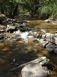
 The Ten Ar River is fed from most of the valley by the Kumbar stream, the Manalaar River (“sand river”), the Kalyanivalasu Odai and other smaller tributaries from the higher forests and sholas to the east. At the northwest end of the valley, the Ten Ar is joined by the Varavandi Odai stream flowing from a smaller adjacent valley to the east and soon joins the Amaravati River 0.8 km (0.497098189319845 mi) down stream to the west. The Amaravati River then flows north to the Amaravathi Reservoir and Dam and then to the Cauvery River.
The Kudiraiyar River basin, including Kukkal
village, is just over the northeast ridge of the valley behind Vellari Malai.
 Manjampatti Valley currently supports stable breeding populations of several large mammal species including apex predator
s critical to healthy populations of smaller animals.
In colonial times Indian Tigers (Tamil: puli) were common in this area and as recently as the 1950s the Raja of Puthukkottai would go out from his house in Kodaikanal and hunt them. At least one Tiger has been shot here within the past fifty five years.. Two Tigers, a male and a female, were sighted and recorded in the 2007 wildlife census. Tiger populations in the adjoining areas of IGWS&NP and the nearby Kalakkad Mundanthurai Tiger Reserve
could expand back into this area if they and their prey species were better protected.
The census estimated 10 to 20 Panther
(Tamil: sirutthai) living in the Manjampatti Valley. Wild Indian Elephant
s roam over the whole valley. Sloth Bear
s (Tamil: karadi) are sighted every year in the upper forests of Manjampatti valley. Nilgiri Thar (Tamil: varaiaadu) live especially on the spectacular high rocky peaks around the valley, as Mudimalai, Jambumalai, and Attumalai, though they may also be seen in the valley forests. There are several herds of Gaur
(popularly called bison) (Tamil: kaattu erumai, “forest buffalo”) in the valley. Earlier the area was well known for Manjampatti White Bison
. This possible sub-species has recently been seen and photographed here by forest Department staff.
 Wild Boar
(Tamil: kaattu panri) live all over the Palani Hills and in Manjampatti Valley, where one can frequently see holes in the ground where they have dug for edible roots. The Valley has the Large mountain squirrel
(Tamil: Malai-anil) and the Ash-colored squirrel
(Tamil: Saambalnira anil).
There are wild peacock
s, jungle fowl
, and many other bird species enumerated in the Wildlife Census.
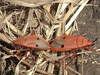
There are no known studies of the many reptiles, amphibians, insects, invertebrates or plants living in the valley.
 There is a well laid-out park nearby at the Amaravathi Dam where one may climb steep steps on the dam to have a picturesque view north of the plains below and south to the Anaimalai Hills
, Manjampatti Valley and Palni Hills
above. This place is being developed as a District Excursion Centre for tourism.
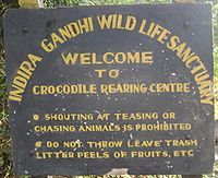
The Park and adjacent Crocodile farm are open every day from 9.00 A.M. to 6.00 P.M. Entry fees are 0.50 paise per adult and 0.25 paise per child (below 12 years).
Travel by road From Coimbatore – via Pollachi and Udumalpet to Amaravathynagar is 96 km (59.7 mi).
Accommodation is available for four persons, with advance reservation, at a Forest Rest House near the Crocodile farm. Rent is Rs.150 per day for two persons per suite.
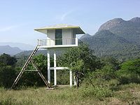 The Sarakupatti Watchtower is a small bare concrete room on a 8 m tower where one can go and wait to see animals. It has a fine view of the whole valley. It is located 1/2 km east of SH-17, 1/2 km north of Chinnar River checkpoint. It is available for overnight lodging. Advance booking is required.
Contact:
Protected area
Protected areas are locations which receive protection because of their recognised natural, ecological and/or cultural values. There are several kinds of protected areas, which vary by level of protection depending on the enabling laws of each country or the regulations of the international...
in the eastern end of Indira Gandhi Wildlife Sanctuary and National Park
Indira Gandhi National Park
Indira Gandhi Wildlife Sanctuary and National Park is a protected area named after Prime Minister Indira Gandhi who visited the park on October 7, 1961. It is often called "Topslip", a village in the northeast corner of the park which is the main visitor center. This name is derived from the local...
(IGWS&NP) in Coimbatore District
Coimbatore District
Coimbatore District is one of the more affluent and industrially advanced districts of the state of Tamil Nadu in India. Coimbatore is known as the Manchester of South India. It one of the most industrialized towns of Tamil Nadu. It has the highest GDP among the districts of Tamil Nadu, even ahead...
, Tamil Nadu
Tamil Nadu
Tamil Nadu is one of the 28 states of India. Its capital and largest city is Chennai. Tamil Nadu lies in the southernmost part of the Indian Peninsula and is bordered by the union territory of Pondicherry, and the states of Kerala, Karnataka, and Andhra Pradesh...
, South India
South India
South India is the area encompassing India's states of Andhra Pradesh, Karnataka, Kerala and Tamil Nadu as well as the union territories of Lakshadweep and Pondicherry, occupying 19.31% of India's area...
. It is a pristine drainage basin
Drainage basin
A drainage basin is an extent or an area of land where surface water from rain and melting snow or ice converges to a single point, usually the exit of the basin, where the waters join another waterbody, such as a river, lake, reservoir, estuary, wetland, sea, or ocean...
of shola
Shola
Sholas are patches of stunted evergreen tropical and subtropical moist broadleaf forest found in valleys amid rolling grassland in the higher montane regions of South India. These patches of shola forest are found mainly in the valleys and are usually separated from one another by undulating...
and montane
Montane
In biogeography, montane is the highland area located below the subalpine zone. Montane regions generally have cooler temperatures and often have higher rainfall than the adjacent lowland regions, and are frequently home to distinct communities of plants and animals.The term "montane" means "of the...
rain Forest with high biodiversity
Biodiversity
Biodiversity is the degree of variation of life forms within a given ecosystem, biome, or an entire planet. Biodiversity is a measure of the health of ecosystems. Biodiversity is in part a function of climate. In terrestrial habitats, tropical regions are typically rich whereas polar regions...
recently threatened by illegal land clearing and cultivation. p. 1,
National Park
a large area of unmodified or slightly modified land, retaining its natural character and influence, without permanent or significant habitation, which is protected and managed so as to preserve its natural condition.
The Tamil Nadu Forest Department
Tamil Nadu Forest Department
The Tamil Nadu Forest Department was established as the Madras Forest Department in 1855 by Dr. Hugh Francis Cleghorn, "the father of scientific forestry in India". The department is responsible for managing all the protected areas and forests plus environmental and wildlife related issues of Tamil...
has divided the valley into 3 administrative areas: Thalinji beat 4290 ha, Manjampatti beat 3741.75 ha and Keelanavayal beat 3058.75 ha. Total = 11,090.5 ha = 110.905 km² (42.8 sq mi)
To the east it adjoins the western ends of the Kodaikanal and Dindigul Forest Districts. These Forests will make up part of the new Kodaikanal Wildlife Sanctuary and the proposed Palani Hills National Park. To the south and west it adjoins Munnar forest Division and Chinnar Wildlife Sanctuary
Chinnar Wildlife Sanctuary
Chinnar Wildlife Sanctuary, , is located 18 km north of Marayoor on SH 17 in the Marayoor and Kanthalloor Panchayats of Devikulam Taluk in the Idukki district of Kerala state in South India. It is one of twelve Wildlife Sanctuaries among the Protected areas of Kerala.It is under the...
in Idukki District
Idukki district
Idukki district is one among the 14 districts of Kerala state, India. The district headquarters is located at in Painavu.It is the second least populous district in Kerala, after Wayanad .-Etymology:...
, Kerala
Kerala
or Keralam is an Indian state located on the Malabar coast of south-west India. It was created on 1 November 1956 by the States Reorganisation Act by combining various Malayalam speaking regions....
. To the north it adjoins the north slope of the Amaravathy River basin in the 172.505 km² (66.6 sq mi) Amaravathy Range of IGWS&NP. p. 2.
Some areas of the drainage basin are not included within the political boundaries of the national park, including the Kodaikanal Taluk villages of Kumbur
Kumbur
Kumbur , is a farming village of 202 houses in Mannavanur Panchayat, at the end of the road west from Kodaikanal in Dindigul district, Tamil Nadu, India. It is at the head of the Kumbur River in Manjampatti Valley drainage basin...
, Mannavanur
Mannavanur
Mannavanur , is a farming village of 1437 households in Mannavanor Panchayat, Dindigul district, Tamil Nadu, India, west from Kodaikanal It is by road from Kumbur village and from Kilanavayal village. Altitude is...
and Kilanavayal
Kilanavayal
Kilanavayal is a small village of terrace farmers in Mannavanur panchayat at the far eastern end of the Manjampatti Valley drainage basin in the Palani Hills. There is a road between Mannavanur and Kilanavayal. There is a trekking route fromMannavanur via Keelanavayal to ManjampattI and...
; Upper Palani Reserve Forest (Kilanavayal) and a 2 km wide strip of the east end of Chinnar Wildlife Sanctuary. p. 180,
The IGWS&NP and the Kodaikanal and Dindigul Forest Districts are designated the Anaimalai Conservation Area, a two year collaborative project of the Wildlife Institute of India
Wildlife Institute of India
The Wildlife Institute of India is a autonomous institution under the Ministry of Environment and Forests, Government of India.WII carries out wildlife research in areas of study like Biodiversity, Endangered Species, Wildlife Policy, Wildlife Management, Wildlife Forensics, Spatial Modeling,...
and the U.S.D.A. Forest Service. Manjampatti Valley is under the protection of the Coimbatore Forest Office; Wildlife Warden-Indira Gandhi Wildlife Sanctuary A license is required for entry.
History
Manjampatti derived its name from two TamilTamil language
Tamil is a Dravidian language spoken predominantly by Tamil people of the Indian subcontinent. It has official status in the Indian state of Tamil Nadu and in the Indian union territory of Pondicherry. Tamil is also an official language of Sri Lanka and Singapore...
words, manjal meaning yellow and patti meaning "cattle fold" or small village; there is a local opinion that it was so named because of endemic wild mango
Mango
The mango is a fleshy stone fruit belonging to the genus Mangifera, consisting of numerous tropical fruiting trees in the flowering plant family Anacardiaceae. The mango is native to India from where it spread all over the world. It is also the most cultivated fruit of the tropical world. While...
trees here.
Iron AgeIron AgeThe Iron Age is the archaeological period generally occurring after the Bronze Age, marked by the prevalent use of iron. The early period of the age is characterized by the widespread use of iron or steel. The adoption of such material coincided with other changes in society, including differing...
(1200-200 BC) Dolmens, consisting of a stone floor slab 3 to 5 feet long, 3 stone walls about 2 feet high, and a “roof” stone slab, found on at least 2 stony hilltops on the edges of the valley.. and..the existence of unexpectedly large temple ruins in the isolated village of Thalinji, and the later (1559 - 1736) assignment of land by Madurai Nayak DynastyMadurai Nayak DynastyThe Madurai Nayaks or Nayak Dynasty of Madurai were rulers of a region comprising most of modern-day Tamil Nadu, India, with Madurai as their capital...
kings to cultivators in the upper Palanis, indicate that there has been continuous interaction from prehistoric times to the present between plains people and the ethnic groups in these hills. Some groups relying on hunting and gathering partially retained their pre-civilizational lifestyle up to the last century.
The earliest known residents of the area are the Palaiyar (meaning "old ones", incorrectly translated as Paliyan), a Tamil-speaking tribal people, who have been seen in the past 35 years living in small caves in the valley. Historically close extended Palaiyar family groups foraged and hunted at least 128 forest species for subsistence. In the past century they increasingly depended on shifting cultivation and collection and trading of non timber forest products of over 60 species for: food (14), incense & toiletries (11) medicines (13), construction materials & precious woods (9) and miscellaneous (13) honey, tubers, fruits, herbs, flowers, bark, seeds, fibers, gum, leaves, logs and oils.
Since establishment of the IGWS&NP in 1976, Palaiyar trading was gradually but severely restricted. They are now allowed to collect only Tamarind from one small area outside Manjampatti Valley. Their strong cultural ties to the area and traditional avoidance of outsiders keeps them attached to their forest habitat. They must now depend on intermittent plantation labor, primitive low yield cultivation in restricted areas, liaisons with forest product smugglers and poachers, government programs and charity.
Communities
In 2002 there were 401 tribalTribe
A tribe, viewed historically or developmentally, consists of a social group existing before the development of, or outside of, states.Many anthropologists use the term tribal society to refer to societies organized largely on the basis of kinship, especially corporate descent groups .Some theorists...
persons living in three settlements within IGWS&NP boundaries in the valley. This is an average population density of 3.65 persons/km², 40% higher than the 2.6 persons/km² living in all 36 tribal settlements in the entire 1769 km² IGWS&NP. Their peaceful ancient culture in this area is increasingly fragmented as they assimilate modern Tamil
Tamil people
Tamil people , also called Tamils or Tamilians, are an ethnic group native to Tamil Nadu, India and the north-eastern region of Sri Lanka. Historic and post 15th century emigrant communities are also found across the world, notably Malaysia, Singapore, Mauritius, South Africa, Australia, Canada,...
customs and values.,. The villages have no link roads, no electricity (some solar lamps have been installed recently), no running water, no government school, no medical facilities and no shops.
In addition there are three villages within the valley watershed but outside the National Park boundaries: Mannavanur
Mannavanur
Mannavanur , is a farming village of 1437 households in Mannavanor Panchayat, Dindigul district, Tamil Nadu, India, west from Kodaikanal It is by road from Kumbur village and from Kilanavayal village. Altitude is...
pop. 5,927 , Kumbur
Kumbur
Kumbur , is a farming village of 202 houses in Mannavanur Panchayat, at the end of the road west from Kodaikanal in Dindigul district, Tamil Nadu, India. It is at the head of the Kumbur River in Manjampatti Valley drainage basin...
pop. 500 , and Kilanavayal 124 families.
Thalinji
Thalinji village at 533 metres (1,748.7 ft), 10°18′45"N 77°15′2"E near the bottom of the valley above the banks of the Ten Ar River, has about 150 houses (pop: m-168, f-155). Most of the people are Pulaiyar caste, early cultivators, but there are some Malaimarasar tribal people, who do agriculture and coolie work.Mariamman
Māri ,Tulu, also known as Mariamman , both meaning "Mother Mari", spelt also Maariamma , or simply Amman or Aatha is the South Indian Hindu goddess of disease and rain. She is the main South Indian mother goddess, predominant in the rural areas of Tamil Nadu, Karnataka, Andhra Pradesh and...
and gods Ganesha
Ganesha
Ganesha , also spelled Ganesa or Ganesh, also known as Ganapati , Vinayaka , and Pillaiyar , is one of the deities best-known and most widely worshipped in the Hindu pantheon. His image is found throughout India and Nepal. Hindu sects worship him regardless of affiliations...
, and Krishna
Krishna
Krishna is a central figure of Hinduism and is traditionally attributed the authorship of the Bhagavad Gita. He is the supreme Being and considered in some monotheistic traditions as an Avatar of Vishnu...
, with some text inscriptions. The villagers say they know no history of the temple.
The village is a Ward under the Manupatti Panchayat near the Amaraavathi dam, but the people have decided to not elect a representative. They do rely on the Forest Department for many kinds of assistance and advice. When the British created the Amaravathi Reserved Forest they allocated 200 acres (80.9 ha) to the village for cultivation. This was divided up among families by stone boundary markers, which still exist, but land titles were not given.
Photovoltaics
Photovoltaics is a method of generating electrical power by converting solar radiation into direct current electricity using semiconductors that exhibit the photovoltaic effect. Photovoltaic power generation employs solar panels composed of a number of solar cells containing a photovoltaic material...
powered home lighting devices from the District collector
District collector
The District Collector is the district head of administration of the bureaucracy in a state of India. Though he/she is appointed and is under general supervision of the state government, he/she has to be a member of the elite IAS recruited by the Central Government...
.
Manjampatti
It is ethnically more diverse than Talinji. Pulaiyar were the majority inhabitants of Manjampatti when the British gave land to the village for cultivation. About 15 families of Muthuvar, another "tribal" group, live in Manjampatti village where they do cultivation and labor work. Some Theivar people, a widespread plains agricultural jaathi (caste), came to live in Manjampatti long ago and engage in agriculture on the village lands. There are also a few houses of other plains jaathis such as Chakkliyar (originally leather-workers). Because of these jaathis, Manjampatti village has some features of plains Tamil villages such as eating of newer types of vegetables and having tea shops.
Manjampatti comes under the Mannavanur
Mannavanur
Mannavanur , is a farming village of 1437 households in Mannavanor Panchayat, Dindigul district, Tamil Nadu, India, west from Kodaikanal It is by road from Kumbur village and from Kilanavayal village. Altitude is...
Panchayat and sends its Ward Member up to the monthly meetings. The people receive no benefit from the Panchayat, and prefer to rely on the Forest Department. Manjampatti falls under Kodaikanal
Kodaikanal
-Climate:Kodaikanal has a monsoon-influenced subtropical highland climate . The temperatures are cool throughout the year due to the high elevation of the city.-Economy:...
Taluk office, and the people must travel far to Kodaikanal for official services such as getting a ration card. The ration items (rice, sugar, kerosene) are sent to an agent on the Amaravaathi-Munnar Road (SH 17) where the people go to collect them. The village has a small part time general store selling cooking items and two part-time tea shops. There is a basic primary school of a type designed for tribal people, which is able to provide Transfer Certificates (TC) to students.
The village has a Moopan (headman), assisted by a group of elder men, who organizes activities such as maintaining irrigation channels and resolving disputes, but this position is not recognized in the Panchayat system. The Moopan can be of any caste
Caste system in India
The Indian caste system is a system of social stratification and social restriction in India in which communities are defined by thousands of endogamous hereditary groups called Jātis....
, and serves as long as he has the confidence of the people. If someone commits a serious crime, the Moopan will turn the suspect over to the Forest Department, which will arrange for him to be detained by police on the plains.
Manjampatti was given land for cultivation when the Reserved Forest was created and the families have kept their respective fields marked with the original stone boundaries. Villagers earlier practiced shifting cultivation
Shifting cultivation
Shifting cultivation is an agricultural system in which plots of land are cultivated temporarily, then abandoned. This system often involves clearing of a piece of land followed by several years of wood harvesting or farming, until the soil loses fertility...
, growing millet
Millet
The millets are a group of small-seeded species of cereal crops or grains, widely grown around the world for food and fodder. They do not form a taxonomic group, but rather a functional or agronomic one. Their essential similarities are that they are small-seeded grasses grown in difficult...
s such as Raagi
Finger millet
Eleusine coracana, commonly Finger millet , also known as African millet or Ragi is an annual plant widely grown as a cereal in the arid areas of Africa and Asia. E...
, Thinai
Foxtail millet
Foxtail millet is the second most widely planted species of millet, and the most important in East Asia. It has the longest history of cultivation among the millets, having been grown in China since sometime in the sixth millennium BC...
and Kambu
Pearl millet
Pearl millet is the most widely grown type of millet. Grown in Africa and the Indian subcontinent since prehistoric times, it is generally accepted that pearl millet originated in Africa and was subsequently introduced into India. The center of diversity, and suggested area of domestication, for...
. Later the Forest Department forbade shifting cultivation and restricted cultivation to the allotted lands. The crops now are rice in rainy season and Butter beans otherwise, though with a more diverse population a few vegetables such as eggplant and tomatoes are grown. Farmers here have to protect their crops from wild elephants, gaur, wild boar, deer and sometimes, peacocks. A complex and well maintained system of small canals distributes water from the Manalar to irrigate the fields.
Muduvankudi is a neighboring village inhabited by Muduvar (Muthuvar), and is a 15-minute trek from Manjampatti.
Mungilpallam
There are 24 Muduvan and Paliyan
Paliyan
The Paliyan, or Palaiyar or Pazhaiyarare are Adivasi Dravidian people living in the South Western Ghats montane rain forests in South India, especially in Tamilnadu and Kerala. They are traditional nomadic hunter-gatherers, honey hunters and foragers. Yams are their major food source...
families living there. They were said to have migrated from Manjampatti 200 years ago because of their fear of herds of wild elephants. They originally lived in caves. They eat wild roots, maize, fruits from wild plants, honey and bamboo rice. Their limited income comes from selling bamboo products and lemon grass oil, which they spend to buy rice from other villages. These people are nature worshippers. They do not worship regularly or have a particular place of worship but have a sacred area in their village. They visit this area to celebrate the harvest festival Pongal
Pongal
Thai Ponggal is a harvest festival celebrated by Tamils in the Indian state of Tamil Nadu, Indian Union Territory of Pondicherry and in Sri Lanka. Pongal coincides with the festival Makara Sankranthi celebrated throughout India. Pongal in Tamil means "boiling over" or "spill over". The boiling...
and the rain (Mari) festival, during which they sacrifice a goat.
They believe that diseases are manifestations of punishment inflicted by God. Till recently they only took native medicines. A witch doctor from the community was summoned for assessment and further treatment of serious illness. If the witch doctor’s said the patient would die, food and medicines were withdrawn and the patient kept in a small hut away other until he or she died. In 2005, more than 50% of the children here suffered from severe chronic malnutrition.
Maangapaarai is another remote settlement and highly inaccessible because of bison attacks.
Geography
Coimbatore District
Coimbatore District is one of the more affluent and industrially advanced districts of the state of Tamil Nadu in India. Coimbatore is known as the Manchester of South India. It one of the most industrialized towns of Tamil Nadu. It has the highest GDP among the districts of Tamil Nadu, even ahead...
,, about 13 km south of Amaravathi Reservoir
Amaravathi Reservoir
Amaravathi Reservoir at Amaravathinagar, south on SH 17 from Udumalpet, is located in Indira Gandhi Wildlife Sanctuary and National Park in Tirupur district, Tamil Nadu, India. The reservoir was created by the steep Amaravathi Dam built across the Amaravathi River. Amaravathi river is tributary...
and Dam
Amaravathi Dam
Amaravathi Dam at Amaravathinagar, 25 km south on NH 17 from Udumalpet, is located in Indira Gandhi Wildlife Sanctuary in Coimbatore district, Tamil Nadu, India. The 9.31 km², 33.53 m deep Amaravathi Reservoir was created by this steep dam. It was built primarily for irrigation and flood...
on SH 17 and 30 km West of Kodaikanal
Kodaikanal
-Climate:Kodaikanal has a monsoon-influenced subtropical highland climate . The temperatures are cool throughout the year due to the high elevation of the city.-Economy:...
at the western border of Dindigul District
Dindigul District
Dindigul District is an administrative region in the south of Tamil Nadu, India. The district was carved out of Madurai District in the year 1985...
in the Palni Hills
Palni Hills
The Palni Hills are a mountain range in Tamil Nadu state of South India. The Palni Hills are an eastward extension of the Western Ghats ranges, which run parallel to the west coast of India. The Palni Hills adjoin the high Anamalai range on the west, and extend east into the plains of Tamil Nadu,...
of the Western Ghats
Western Ghats
The Western Ghats, Western Ghauts or the Sahyādri is a mountain range along the western side of India. It runs north to south along the western edge of the Deccan Plateau, and separates the plateau from a narrow coastal plain along the Arabian Sea. The Western Ghats block rainfall to the Deccan...
mountain range.
Central location is 10°18.5′N 77°17′E. Elevation ranges from at Vellari Malai peak 10°14′50"N 77°21′4"E towering over the valley at Kumbur village 10°13.6′N 77°19.5′E on eastern ridge (outside IGWSNP) at Mannavanur village 10°13′N 77°21′E sitting to the south east on a small plateau overlooking the valley (outside IGWSNP) at Alanthoni Falls 10°17′34"N 77°16′12"E, 20 metres (65.6 ft) tall, on Ten Ar River west of Manjampatti Village lowest point in the valley at the Amaravathi River 10°21′2"N 77°14′14"E
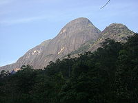
Peaks
- Tavatti Malai 943 metres (3,093.8 ft) 10°19′53"N 77°17′7"E
- Unnamed 1700 metres (5,577.4 ft) 10°19′6"N 77°18′41"E
- Chinna Mudi Malai 1836 metres (6,023.6 ft) 10°19′7"N 77°19′6"E
- Mudian Malai 1836 metres (6,023.6 ft) 10°19′15"N 77°19′23"E,
- Unnamed 1793 metres (5,882.5 ft) 10°17′27"N 77°20′49"E
- Pappalamman Malai 2201 metres (7,221.1 ft) 10°17′29"N 77°21′04"E
- Vellari Malai 2219 metres (7,280.2 ft) 10°15′46"N 77°20′56"E
- Unnamed at Kilanavayal 2350 metres (7,710 ft) 10°14′55"N 77°21′22"E
- Paratumba 2260 metres (7,414.7 ft) 10°13′39"N 77°17′24"E
- Kalabhaathur Malai 2066 metres (6,778.2 ft) 10°14′09"N 77°16′13"E
- Kadavaari 2112 metres (6,929.1 ft) 10°13′40"N 77°17′24"E
- Vellingiri Malai 1769 metres (5,803.8 ft) 10°14′53"N 77°14′12"E
- Jambu Malai 1395 metres (4,576.8 ft) 10°15′51"N 77°15′48"E
- Palappatti 1357 metres (4,452.1 ft) 10°17′7"N 77°13′21"E.
From here the ridge drops to the Amaravathi River.
The western ridge of Manjampatti Valley extends 2 km into the easternmost area of Idukki District
Idukki district
Idukki district is one among the 14 districts of Kerala state, India. The district headquarters is located at in Painavu.It is the second least populous district in Kerala, after Wayanad .-Etymology:...
, Kerala
Kerala
or Keralam is an Indian state located on the Malabar coast of south-west India. It was created on 1 November 1956 by the States Reorganisation Act by combining various Malayalam speaking regions....
and adjoins the 90 km² Chinnar Wildlife Sanctuary
Chinnar Wildlife Sanctuary
Chinnar Wildlife Sanctuary, , is located 18 km north of Marayoor on SH 17 in the Marayoor and Kanthalloor Panchayats of Devikulam Taluk in the Idukki district of Kerala state in South India. It is one of twelve Wildlife Sanctuaries among the Protected areas of Kerala.It is under the...
.
Rivers
The Manjampatti Valley catchment basin drains into the Chinnar RiverChinnar River
The Chinnar River originates in the Annaimalai Hills below a grassy pass between the hills Kumarikal Malai and Kaladekatti Malai In Idukki District, Kerala state South India...
from the Athioda Stream and to the Amaravathi River from the Kajadaikatti Odai Ar and Ten Ar Rivers 2 kilometres (1.2 mi) to the east.
Amaravati River
The Amaravati River is a tributary of Kaveri River in Coimbatore District, Tamil Nadu state, South India. It is continuation of the Pambar and Chinnar rivers in Kerala.-Route:...
in Tamil Nadu.
The Kudiraiyar River basin, including Kukkal
Kukkal
Kukkal is a Panchayat village of terrace farmers at the far western end of the Palani Hills in Kodaikanal block of Dindigul district, Tamil Nadu state, South India. It is from Kodaikanal at: . Elevation is . Kookal is notable for the high biodiversity of the area.-Geography:Kukkal sits at the...
village, is just over the northeast ridge of the valley behind Vellari Malai.
Wildlife
Apex predator
Apex predators are predators that have no predators of their own, residing at the top of their food chain. Zoologists define predation as the killing and consumption of another organism...
s critical to healthy populations of smaller animals.
In colonial times Indian Tigers (Tamil: puli) were common in this area and as recently as the 1950s the Raja of Puthukkottai would go out from his house in Kodaikanal and hunt them. At least one Tiger has been shot here within the past fifty five years.. Two Tigers, a male and a female, were sighted and recorded in the 2007 wildlife census. Tiger populations in the adjoining areas of IGWS&NP and the nearby Kalakkad Mundanthurai Tiger Reserve
Kalakkad Mundanthurai Tiger Reserve
Kalakkad Mundanthurai Tiger Reserve , situated in the Southern Western Ghats in Tirunelveli district, in the South Indian state of Tamil Nadu, is the second largest protected area in Tamil Nadu State.-History:...
could expand back into this area if they and their prey species were better protected.
The census estimated 10 to 20 Panther
Indian leopard
The Indian leopard is a leopard subspecies widely distributed on the Indian subcontinent. It is one of the five big cats found in India, apart from Asiatic lion, Bengal tiger, snow leopard and clouded leopard....
(Tamil: sirutthai) living in the Manjampatti Valley. Wild Indian Elephant
Indian Elephant
The Indian Elephant is one of three recognized subspecies of the Asian elephant, and native to mainland Asia. Since 1986, Elephas maximus has been listed as endangered by IUCN as the population has declined by at least 50% over the last three generations, estimated to be 60–75 years...
s roam over the whole valley. Sloth Bear
Sloth Bear
The sloth bear , also known as the labiated bear, is a nocturnal insectivorous species of bear found wild within the Indian subcontinent. The sloth bear evolved from ancestral brown bears during the Pleistocene and shares features found in insect-eating mammals through convergent evolution...
s (Tamil: karadi) are sighted every year in the upper forests of Manjampatti valley. Nilgiri Thar (Tamil: varaiaadu) live especially on the spectacular high rocky peaks around the valley, as Mudimalai, Jambumalai, and Attumalai, though they may also be seen in the valley forests. There are several herds of Gaur
Gaur
The gaur , also called Indian bison, is a large bovine native to South Asia and Southeast Asia. The species is listed as vulnerable on the IUCN Red List since 1986 as the population decline in parts of the species' range is likely to be well over 70% over the last three generations...
(popularly called bison) (Tamil: kaattu erumai, “forest buffalo”) in the valley. Earlier the area was well known for Manjampatti White Bison
Manjampatti White Bison
Manjampatti white bison are a type of gaur, occasionally seen in the Manjampatti Valley, a protected area at the eastern end of Indira Gandhi Wildlife Sanctuary and National Park in Coimbatore District, Tamil Nadu, South India. These gaur are notable for their distinctive ash-grey color as...
. This possible sub-species has recently been seen and photographed here by forest Department staff.
Boar
Wild boar, also wild pig, is a species of the pig genus Sus, part of the biological family Suidae. The species includes many subspecies. It is the wild ancestor of the domestic pig, an animal with which it freely hybridises...
(Tamil: kaattu panri) live all over the Palani Hills and in Manjampatti Valley, where one can frequently see holes in the ground where they have dug for edible roots. The Valley has the Large mountain squirrel
Indian Giant Squirrel
The Indian giant squirrel, or Malabar giant squirrel, is a large tree squirrel species genus Ratufa native to India. It is a large-bodied diurnal, arboreal, and herbivorous squirrel found in South Asia.-Description:...
(Tamil: Malai-anil) and the Ash-colored squirrel
Indian Palm Squirrel
The Indian Palm Squirrel also known as Three-Striped Palm Squirrel, is a species of rodent in the Sciuridae family that can be easily domesticated and kept as pets. It is found naturally in India and Sri Lanka...
(Tamil: Saambalnira anil).
There are wild peacock
Peafowl
Peafowl are two Asiatic species of flying birds in the genus Pavo of the pheasant family, Phasianidae, best known for the male's extravagant eye-spotted tail, which it displays as part of courtship. The male is called a peacock, the female a peahen, and the offspring peachicks. The adult female...
s, jungle fowl
Grey Junglefowl
The Grey Junglefowl , also known as Sonnerat's Junglefowl, is a wild relative of domestic fowl that is endemic to India. This species is found mainly in peninsular India and where it overlaps with the distribution of the Red Junglefowl, it is known to form hybrids...
, and many other bird species enumerated in the Wildlife Census.
There are no known studies of the many reptiles, amphibians, insects, invertebrates or plants living in the valley.
Visitor information
Manjampatti valley is a core zone of the Indira Gandhi National Park. Tourism, hiking, camping and non-resident visitation of the villages is prohibited. A permit is required for serious researchers to work inside the valley.Anaimalai Hills
The Anaimalai Hills is a range of mountains in the Western Ghats in Tamil Nadu and Kerala states of South India. The name "Anaimalai" derives from the Tamil word 'Ana' meaning elephant and 'Mala' meaning hill, thus Elephant Hill. The highest peak of the Anaimalai Hills is Anamudi, , located in the...
, Manjampatti Valley and Palni Hills
Palni Hills
The Palni Hills are a mountain range in Tamil Nadu state of South India. The Palni Hills are an eastward extension of the Western Ghats ranges, which run parallel to the west coast of India. The Palni Hills adjoin the high Anamalai range on the west, and extend east into the plains of Tamil Nadu,...
above. This place is being developed as a District Excursion Centre for tourism.
The Park and adjacent Crocodile farm are open every day from 9.00 A.M. to 6.00 P.M. Entry fees are 0.50 paise per adult and 0.25 paise per child (below 12 years).
Travel by road From Coimbatore – via Pollachi and Udumalpet to Amaravathynagar is 96 km (59.7 mi).
Accommodation is available for four persons, with advance reservation, at a Forest Rest House near the Crocodile farm. Rent is Rs.150 per day for two persons per suite.
Contact:
- Forest Range Officer, Amaravathy Range, Amaravathy nagar, Ph. No. 94434 96413
- Wildlife Warden, Indira Gandhi Wildlife Sanctuary and National Park, 365/1 Meenkarai Road, Pollachi-1, Ph. No. 04259 225356, Email: IGWLSNPPOY@rediffmail.com