
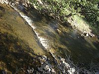
Chinnar River
Encyclopedia
Idukki district
Idukki district is one among the 14 districts of Kerala state, India. The district headquarters is located at in Painavu.It is the second least populous district in Kerala, after Wayanad .-Etymology:...
, Kerala
Kerala
or Keralam is an Indian state located on the Malabar coast of south-west India. It was created on 1 November 1956 by the States Reorganisation Act by combining various Malayalam speaking regions....
state South India
South India
South India is the area encompassing India's states of Andhra Pradesh, Karnataka, Kerala and Tamil Nadu as well as the union territories of Lakshadweep and Pondicherry, occupying 19.31% of India's area...
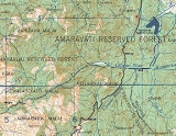
. The 18 km long Chinnar river defines the East-West Tamil Nadu
Tamil Nadu
Tamil Nadu is one of the 28 states of India. Its capital and largest city is Chennai. Tamil Nadu lies in the southernmost part of the Indian Peninsula and is bordered by the union territory of Pondicherry, and the states of Kerala, Karnataka, and Andhra Pradesh...
/Kerala state boundary along the northern edge of the Chinnar Wildlife Sanctuary
Chinnar Wildlife Sanctuary
Chinnar Wildlife Sanctuary, , is located 18 km north of Marayoor on SH 17 in the Marayoor and Kanthalloor Panchayats of Devikulam Taluk in the Idukki district of Kerala state in South India. It is one of twelve Wildlife Sanctuaries among the Protected areas of Kerala.It is under the...
and the southern edge of the Indira Gandhi Wildlife Sanctuary
Indira Gandhi National Park
Indira Gandhi Wildlife Sanctuary and National Park is a protected area named after Prime Minister Indira Gandhi who visited the park on October 7, 1961. It is often called "Topslip", a village in the northeast corner of the park which is the main visitor center. This name is derived from the local...
. Several adult Crocodiles were reported in the Chinnar river in 1992.
Route
The river first proceeds through a large sholaShola
Sholas are patches of stunted evergreen tropical and subtropical moist broadleaf forest found in valleys amid rolling grassland in the higher montane regions of South India. These patches of shola forest are found mainly in the valleys and are usually separated from one another by undulating...
then past the Muthuvar settlement of Olikkudi at 10.331°N 77.1435°E. There is another small village #2 at 10.3553°N 77.1839°E. There are Kerala and Tamil Nadu border checkpoints on either side of the river where a SH 17 road bridge crosses the river at 10.35241°N 77.21775°E. 2 km east it is joined from the south by the Pambar River
Pambar River
The Pambar River originates in the Anaimudi Hills in Idukki District of Kerala state in South India.-Route:It traverses Turner’s Valley in Eravikulam National Park and flows into the Chinnar Wildlife Sanctuary through the Taliar Valley between Kanthalloor and Marayoor Villages and eastwards through...
at Koottar where a comfortable tree house accommodation is available. Here it crosses into Indira Gandhi Wildlife Sanctuary in Tamil Nadu and becomes the Amaravati River
Amaravati River
The Amaravati River is a tributary of Kaveri River in Coimbatore District, Tamil Nadu state, South India. It is continuation of the Pambar and Chinnar rivers in Kerala.-Route:...
.
Tributaries
The river is joined by a small stream from the south at small village #2. 2 km east of the NH 17 road bridge the river is joined from the south by the Pambar RiverPambar River
The Pambar River originates in the Anaimudi Hills in Idukki District of Kerala state in South India.-Route:It traverses Turner’s Valley in Eravikulam National Park and flows into the Chinnar Wildlife Sanctuary through the Taliar Valley between Kanthalloor and Marayoor Villages and eastwards through...
at Koottar. The western part of the Manjampatti Valley
Manjampatti Valley
Manjampatti Valley is a protected area in the eastern end of Indira Gandhi Wildlife Sanctuary and National Park in Coimbatore District, Tamil Nadu, South India. It is a pristine drainage basin of shola and montane rain Forest with high biodiversity recently threatened by illegal land clearing...
catchment basin drains into the end of the Chinnar River. This Valley is drained by the stream Ten Ar and a smaller unnamed stream 2 km to its west. The unnamed stream is the N-S political boundary between Tamil Nadu and Kerala. The top of the ridge above this stream to the west is the western limit of the catchment. This unnamed stream joins the Pambar River at the point they both join the Chinnar River at the north west corner of the Valley.