

Kilanavayal
Encyclopedia
Terrace (agriculture)
Terraces are used in farming to cultivate sloped land. Graduated terrace steps are commonly used to farm on hilly or mountainous terrain. Terraced fields decrease erosion and surface runoff, and are effective for growing crops requiring much water, such as rice...
farmers in Mannavanur
Mannavanur
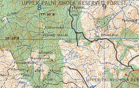
Mannavanur , is a farming village of 1437 households in Mannavanor Panchayat, Dindigul district, Tamil Nadu, India, west from Kodaikanal It is by road from Kumbur village and from Kilanavayal village. Altitude is...
panchayat at the far eastern end of the Manjampatti Valley
Manjampatti Valley
Manjampatti Valley is a protected area in the eastern end of Indira Gandhi Wildlife Sanctuary and National Park in Coimbatore District, Tamil Nadu, South India. It is a pristine drainage basin of shola and montane rain Forest with high biodiversity recently threatened by illegal land clearing...
drainage basin in the Palani Hills. There is a 9 kilometres (5.6 mi) road between Mannavanur and Kilanavayal. There is a trekking route from
Mannavanur via Keelanavayal (90 mins.) to ManjampattI (3 hours) and Thalinji (2 hours). It is in Kodaikanal
Kodaikanal
-Climate:Kodaikanal has a monsoon-influenced subtropical highland climate . The temperatures are cool throughout the year due to the high elevation of the city.-Economy:...
block of Dindigul district
Dindigul District
Dindigul District is an administrative region in the south of Tamil Nadu, India. The district was carved out of Madurai District in the year 1985...
, Tamil Nadu
Tamil Nadu
Tamil Nadu is one of the 28 states of India. Its capital and largest city is Chennai. Tamil Nadu lies in the southernmost part of the Indian Peninsula and is bordered by the union territory of Pondicherry, and the states of Kerala, Karnataka, and Andhra Pradesh...
state, India
India
India , officially the Republic of India , is a country in South Asia. It is the seventh-largest country by geographical area, the second-most populous country with over 1.2 billion people, and the most populous democracy in the world...
. Altitude is 1755 metres (5,757.9 ft) at: 10°15′53"N 77°19′40"E.
Employment
Out of 124 households reporting income, the means of livelihood are: casual labour 37, sub sistence cultivation 31, artisan 56, salary 3.Health
Drinking water for 124 households is supplied from a source within an elevation of more than 50 meters, while water for 99 households is from less than 50 meters. There is a lack of sanitary latrine facilities. Out of a total of 124 homes: 67 use open defection, 54 use a group latrine with regular water supply, none use a clean group latrine with regular water supply and a regular sweeper and only 3 use a private latrine.Education
There is a Panchayat Union upper primary school here.Out of 124 children 5–14 years old, 67 are working and not going to school, 56 are going to school and working and 1 is going to school and not working. Household literacy rate is 70%.