Manda Island
Encyclopedia
Manda is an island
of the Lamu Archipelago of Kenya
, known for the prosperous 9th century port
s of Takwa
and Manda town. The island is now linked by ferry
to Lamu
and is home to Manda Airport
, while Manda Toto island lies to its west. The island is separated from the mainland by the narrow Mkanda channel.
Both Manda town and Takwa were probably abandoned due to lack of water in the first half of the 19th century. In the 1960s the Kenya Department of Agriculture recommended building several concrete catchments called jabias to capture rain water on the island. Two jabias were built and many families moved onto the island, farming maize
, cassava
, simsim
and cotton
.
in 1965. The town owed its origins in the 9th and 10th centuries to trade with the Persian Gulf
. The chief trading commodity was probably elephant ivory
; mangrove
poles were probably also important. From the earliest period the inhabitants of Manda were building with burnt square brick and stone and set with a lime
mortar. These building techniques are found only on the coast and on the islands of Kenya; they have not been used in the interior of the country , whereas the bricks averaging about 18 cm (which "match perfectly ...in measure") are unique for East Africa for this period, and are likely to have been brought in from Sohar
, in Oman
, initially as ballast
in the sailing ships entering the port.From the mid-9th century to the early 11th century buildings were also constructed from coral known as coral rag cut from dead coral reef
s.
The large scale excavations in 1966, 1970 and 1978, revealed an unrivalled prosperity for the period and include Chinese porcelain
dating from the ninth century onward, Islamic pottery
and glass, and local pottery datable by the associated imports. The most striking feature of the town are large sea walls
built in a period between the 9th century to the 13th century. Running parallel with the sea with returns running inland, these walls built from large coral blocks are deduced to have been constructed partly to reclaim sections of the shore, and partly to consolidate the edges of the peninsula.
At the heights of its power the town covered some 40 acres (161,874.4 m²) and its population is estimated to have been about 3,500. Manda prospered until the 13th century when it began to decline.
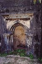
 The Takwa Ruins was a 1500-1700 town, and it was designated a Kenyan National Monument in 1982.
Island
An island or isle is any piece of sub-continental land that is surrounded by water. Very small islands such as emergent land features on atolls can be called islets, cays or keys. An island in a river or lake may be called an eyot , or holm...
of the Lamu Archipelago of Kenya
Kenya
Kenya , officially known as the Republic of Kenya, is a country in East Africa that lies on the equator, with the Indian Ocean to its south-east...
, known for the prosperous 9th century port
Port
A port is a location on a coast or shore containing one or more harbors where ships can dock and transfer people or cargo to or from land....
s of Takwa
Takwa
The Takwa settlement is situated on the south side of Manda Island, in the Lamu District in the coastal province of Kenya. They are the ruins of a Muslim town which was abandoned around the 18th century....
and Manda town. The island is now linked by ferry
Ferry
A ferry is a form of transportation, usually a boat, but sometimes a ship, used to carry primarily passengers, and sometimes vehicles and cargo as well, across a body of water. Most ferries operate on regular, frequent, return services...
to Lamu
Lamu
-Threats to Lamu:In a 2010 report titled Saving Our Vanishing Heritage, Global Heritage Fund identified Lamu as one of 12 worldwide sites most "On the Verge" of irreparable loss and damage, citing insufficient management and development pressure as primary causes.- See also :* Juma and the Magic...
and is home to Manda Airport
Manda Airport
-Location:Manda Airport is located in on Manda Island, Lamu District, Coast Province, in the Lamu Archipelago on the western shores of the Indian Ocean, on the Kenya coast....
, while Manda Toto island lies to its west. The island is separated from the mainland by the narrow Mkanda channel.
Both Manda town and Takwa were probably abandoned due to lack of water in the first half of the 19th century. In the 1960s the Kenya Department of Agriculture recommended building several concrete catchments called jabias to capture rain water on the island. Two jabias were built and many families moved onto the island, farming maize
Maize
Maize known in many English-speaking countries as corn or mielie/mealie, is a grain domesticated by indigenous peoples in Mesoamerica in prehistoric times. The leafy stalk produces ears which contain seeds called kernels. Though technically a grain, maize kernels are used in cooking as a vegetable...
, cassava
Cassava
Cassava , also called yuca or manioc, a woody shrub of the Euphorbiaceae native to South America, is extensively cultivated as an annual crop in tropical and subtropical regions for its edible starchy tuberous root, a major source of carbohydrates...
, simsim
Sesame
Sesame is a flowering plant in the genus Sesamum. Numerous wild relatives occur in Africa and a smaller number in India. It is widely naturalized in tropical regions around the world and is cultivated for its edible seeds, which grow in pods....
and cotton
Cotton
Cotton is a soft, fluffy staple fiber that grows in a boll, or protective capsule, around the seeds of cotton plants of the genus Gossypium. The fiber is almost pure cellulose. The botanical purpose of cotton fiber is to aid in seed dispersal....
.
History
The Manda town ruins (by the coast on the NW side), were first explored by the archaeologist Neville ChittickNeville Chittick
Dr. Neville H. Chittick was a British scholar and archaeologist. His expeditions and residence in East Africa produced a body of research into the ancient and pre-colonial sites of Aksum, Hafun, Kilwa Kisiwani, and the port of Manda Island...
in 1965. The town owed its origins in the 9th and 10th centuries to trade with the Persian Gulf
Persian Gulf
The Persian Gulf, in Southwest Asia, is an extension of the Indian Ocean located between Iran and the Arabian Peninsula.The Persian Gulf was the focus of the 1980–1988 Iran-Iraq War, in which each side attacked the other's oil tankers...
. The chief trading commodity was probably elephant ivory
Elephant and mammoth ivory
Elephant and mammoth tusk ivory comes from the two modified upper incisors of extant and extinct members of the order Proboscidea. Mammoths are believed to have been extinct for 10,000 years. Because of the geographical range in Alaska and Siberia, Mammuthus primigenius tusks have been well preserved...
; mangrove
Mangrove
Mangroves are various kinds of trees up to medium height and shrubs that grow in saline coastal sediment habitats in the tropics and subtropics – mainly between latitudes N and S...
poles were probably also important. From the earliest period the inhabitants of Manda were building with burnt square brick and stone and set with a lime
Lime (mineral)
Lime is a general term for calcium-containing inorganic materials, in which carbonates, oxides and hydroxides predominate. Strictly speaking, lime is calcium oxide or calcium hydroxide. It is also the name for a single mineral of the CaO composition, occurring very rarely...
mortar. These building techniques are found only on the coast and on the islands of Kenya; they have not been used in the interior of the country , whereas the bricks averaging about 18 cm (which "match perfectly ...in measure") are unique for East Africa for this period, and are likely to have been brought in from Sohar
Sohar
Sohar is the most developed city in Sultanate of Oman outside the capital Muscat. It is about 200 kilometers north of Muscat. Sohar was an ancient capital of Oman and many believe it to be the birthplace of Sinbad the Sailor...
, in Oman
Oman
Oman , officially called the Sultanate of Oman , is an Arab state in southwest Asia on the southeast coast of the Arabian Peninsula. It is bordered by the United Arab Emirates to the northwest, Saudi Arabia to the west, and Yemen to the southwest. The coast is formed by the Arabian Sea on the...
, initially as ballast
Sailing ballast
Ballast is used in sailboats to provide moment to resist the lateral forces on the sail. Insufficiently ballasted boats will tend to tip, or heel, excessively in high winds. Too much heel may result in the boat capsizing. If a sailing vessel should need to voyage without cargo then ballast of...
in the sailing ships entering the port.From the mid-9th century to the early 11th century buildings were also constructed from coral known as coral rag cut from dead coral reef
Coral reef
Coral reefs are underwater structures made from calcium carbonate secreted by corals. Coral reefs are colonies of tiny living animals found in marine waters that contain few nutrients. Most coral reefs are built from stony corals, which in turn consist of polyps that cluster in groups. The polyps...
s.
The large scale excavations in 1966, 1970 and 1978, revealed an unrivalled prosperity for the period and include Chinese porcelain
Chinese porcelain
Chinese ceramic ware shows a continuous development since the pre-dynastic periods, and is one of the most significant forms of Chinese art. China is richly endowed with the raw materials needed for making ceramics. The first types of ceramics were made during the Palaeolithic era...
dating from the ninth century onward, Islamic pottery
Islamic pottery
Medieval Islamic pottery occupied a geographical position between Chinese ceramics and the pottery of the Byzantine Empire and Europe. For most of the period it can fairly be said to have been between the two in terms of aesthetic achievement and influence as well, borrowing from China and...
and glass, and local pottery datable by the associated imports. The most striking feature of the town are large sea walls
Seawall
A seawall is a form of coastal defence constructed where the sea, and associated coastal processes, impact directly upon the landforms of the coast. The purpose of a seawall is to protect areas of human habitation, conservation and leisure activities from the action of tides and waves...
built in a period between the 9th century to the 13th century. Running parallel with the sea with returns running inland, these walls built from large coral blocks are deduced to have been constructed partly to reclaim sections of the shore, and partly to consolidate the edges of the peninsula.
At the heights of its power the town covered some 40 acres (161,874.4 m²) and its population is estimated to have been about 3,500. Manda prospered until the 13th century when it began to decline.
Takwa

Manda Airport
Manda Airport is the only airport in the Lamu Archipelago.Further reading
- Wilson, Thomas H.: Takwa: An Ancient Swahili Settlement of the Lamu Archipelago. Kenya Museum Society.

