
Maatsuyker Islands
Encyclopedia
Island
An island or isle is any piece of sub-continental land that is surrounded by water. Very small islands such as emergent land features on atolls can be called islets, cays or keys. An island in a river or lake may be called an eyot , or holm...
s and rocks
Islet
An islet is a very small island.- Types :As suggested by its origin as islette, an Old French diminutive of "isle", use of the term implies small size, but little attention is given to drawing an upper limit on its applicability....
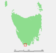
located 5.5 kilometres off the south coast
South Coast Tasmania
South Coast TasmaniaIs a term used in Tasmania - which is sometimes conflated with the South West Tasmania wilderness region.South East Cape is commonly used as a reference point of the eastern limit, and South West Cape the western end.-External links:*...
of Tasmania
Tasmania
Tasmania is an Australian island and state. It is south of the continent, separated by Bass Strait. The state includes the island of Tasmania—the 26th largest island in the world—and the surrounding islands. The state has a population of 507,626 , of whom almost half reside in the greater Hobart...
. Maatsuyker Island
Maatsuyker Island
Maatsuyker Island is a lying close to the southern end of the south-western coast of Tasmania, Australia. It is part of the Maatsuyker Island Group which is included in the Southwest National Park, and the Tasmanian Wilderness World Heritage Site. It is the site of the Maatsuyker Island Lighthouse...
is the southernmost island of the group and of the Australia
Australia
Australia , officially the Commonwealth of Australia, is a country in the Southern Hemisphere comprising the mainland of the Australian continent, the island of Tasmania, and numerous smaller islands in the Indian and Pacific Oceans. It is the world's sixth-largest country by total area...
n continental shelf
Continental shelf
The continental shelf is the extended perimeter of each continent and associated coastal plain. Much of the shelf was exposed during glacial periods, but is now submerged under relatively shallow seas and gulfs, and was similarly submerged during other interglacial periods. The continental margin,...
. There are exposed rocks further south of Maatsuyker but they do not meet the definition of "islands". Macquarie Island
Macquarie Island
Macquarie Island lies in the southwest corner of the Pacific Ocean, about half-way between New Zealand and Antarctica, at 54°30S, 158°57E. Politically, it has formed part of the Australian state of Tasmania since 1900 and became a Tasmanian State Reserve in 1978. In 1997 it became a world heritage...
, far to the south, is also Australian territory but it is an upthrust piece of ocean floor in the remote Southern Ocean and is in a geological sense completely separate from the continent.
The group is noted for its rich marine wildlife, predominantly wet and windy weather conditions, and Australia's most southerly lighthouse
Lighthouse
A lighthouse is a tower, building, or other type of structure designed to emit light from a system of lamps and lenses or, in older times, from a fire, and used as an aid to navigation for maritime pilots at sea or on inland waterways....
. The group is part of the Southwest National Park
Southwest National Park
The Southwest National Park is a national park located in the south-west of Tasmania, Australia. The park is Tasmania's largest and forms part of the Tasmanian Wilderness World Heritage Area....
and thus also part of the Tasmanian Wilderness
Tasmanian Wilderness
The Tasmanian Wilderness is a term that is used for a range of areas in Tasmania, Australia.The World Heritage Areas in South West, Western and Central are the most well known. However, there are also other areas in Tasmania that have the elements of being known as wilderness areas, the Tarkine...
World Heritage Site
World Heritage Site
A UNESCO World Heritage Site is a place that is listed by the UNESCO as of special cultural or physical significance...
.
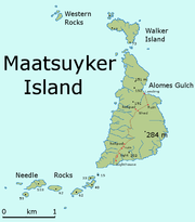
Main Group
The group consists of at least six islands and two groups of rocks. The main island after which the group is named, Maatsuyker Island, is approximately 2.6 kilometres long north/south at its longest on a bearing of 196°, by 1.2 kilometres wide east/west at its widest on a bearing of 105°. Needle Rocks (also known unofficially as The Needles) lie just off the south west tip of Maatsuyker Island. Walker Island, Flat Witch Island and the Western Rocks lie just to the north. De Witt Island lies some 6.5 kilometres to the north-east, and the remaining two islands, Flat Top Island and Round Top Island, are some 7 kilometres to the east. Maatsuyker Island is near the south side of the group, and its distance from the Tasmanian mainland is around 10.4 kilometres.| Name | Coordinates | Aliases |
|---|---|---|
| De Witt Island De Witt Island De Witt Island, also known as Big Witch, is a island in south-eastern Australia. It is the largest of the Maatsuyker Island Group, lying close to the southern end of the south-western coast of Tasmania. Its highest point is above mean sea level. It is part of the Southwest National Park, and... |
43°35′51"S 146°21′35"E | Big Witch |
| Flat Top Island Flat Top Island Flat Top Island is a 1.58 ha island in south-eastern Australia. It is part of the Maatsuyker Island Group, lying close to the southern end of the south-western coast of Tasmania. It is also part of the Southwest National Park, and thus within the Tasmanian Wilderness World Heritage Site... |
43°38′24"S 146°23′03"E | |
| Flat Witch Island Flat Witch Island Flat Witch Island, also known as Little Witch, is a 64 ha island in south-eastern Australia. It is part of the Maatsuyker Island Group, lying close to the southern end of the south-western coast of Tasmania. Its highest point is over 100 m asl. It is part of the Southwest National Park, and thus... |
43°37′08"S 146°17′35"E | |
| Maatsuyker Island Maatsuyker Island Maatsuyker Island is a lying close to the southern end of the south-western coast of Tasmania, Australia. It is part of the Maatsuyker Island Group which is included in the Southwest National Park, and the Tasmanian Wilderness World Heritage Site. It is the site of the Maatsuyker Island Lighthouse... |
43°39′18"S 146°16′23"E | |
| Needle Rocks Needle Rocks The Needle Rocks, also known as the Needles, are a group of five main rocks with a combined area of about 10.5 ha, in south-eastern Australia. They are part of the Maatsuyker Island Group, lying close to the southern end of the south-western coast of Tasmania. They are part of the Southwest... |
43°39′45"S 146°15′19"E | The Needles |
| Round Top Island Round Top Island (Tasmania) Round Top Island is a 6.25 hectare island in south-eastern Australia. Its highest point is 165m above sea level. It is part of the Maatsuyker Island Group, lying close to the southern end of the south-western coast of Tasmania. It is also part of the Southwest National Park, and thus within the... |
43°38′37"S 146°22′33"E | |
| Walker Island Walker Island Walker Island is a 15 ha island in south-eastern Australia. It lies close to the northern end of Maatsuyker Island and is part of the Maatsuyker Island Group, lying close to the southern end of the south-western coast of Tasmania. It is also part of the Southwest National Park, and thus within... |
43°37′57"S 146°16′33"E | |
| Western Rocks Western Rocks (Tasmania) The Western Rocks, also known as Black Rocks, comprise a pair of steep islets, wave-washed in heavy storms, with a combined area of 0.29 ha, in south-eastern Australia. They are part of the Maatsuyker Island Group, lying close to the southern end of the south-western coast of Tasmania... |
43°37′46"S 146°15′29"E | Black Rocks |
Sources differ on whether nearby islands are part of the group. Parks and Wildlife Service, includes only the base set above. Brothers includes four extra in an extended group.
| Chicken Island Chicken Island (Tasmania) Chicken Island is a low, flat, 1.95 ha island in south-eastern Australia. It is part of the Maatsuyker Island Group, lying close to the southern end of the south-western coast of Tasmania... |
43°34′23"S 146°36′04"E | |
| Hen Island Hen Island (Tasmania) Hen Island is a long, narrow, 7.6 hectare island in south-eastern Australia. It is part of the Maatsuyker Island Group, lying close to the southern end of the south-western coast of Tasmania. Its highest point is 75 m Above Sea Level. It is part of the Southwest National Park, and thus within... |
43°34′12"S 146°34′59"E | |
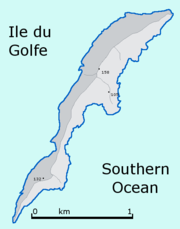
| Ile du Golfe Ile du Golfe (Tasmania) Ile du Golfe is a long, narrow, 68 ha limestone island in south-eastern Australia. It is part of the Maatsuyker Island Group, lying close to the southern end of the south-western coast of Tasmania. Its highest point is 150 m asl. It is part of the Southwest National Park, and thus within the... |
43°34′15"S 146°31′30"E | |
| Louisa Island Louisa Island (Tasmania) Louisa Island is an irregularly shaped 23 ha island in south-eastern Australia. It is part of the Maatsuyker Island Group, lying close to the southern end of the south-western coast of Tasmania. Its highest point is 80 m asl and, at low tide, it is joined to the mainland by a 250 m sand spit... |
43°32′13"S 146°20′42"E |
The islands are erosional remnants of the Tasmanian mainland, and are typically steep-sided and rocky.
Related Islands
White and Brothers refer to islands in addition to those in the group. These include Breaksea Islands, Eddystone, Kathleen Island, Mewstone, Pedra Branca, Shanks Islands and Trumpeter Islets. Several of these are quite distant from Maatsuyker Island.Origin of the name
Abel TasmanAbel Tasman
Abel Janszoon Tasman was a Dutch seafarer, explorer, and merchant, best known for his voyages of 1642 and 1644 in the service of the VOC . His was the first known European expedition to reach the islands of Van Diemen's Land and New Zealand and to sight the Fiji islands...
led the first known European expedition
Exploration
Exploration is the act of searching or traveling around a terrain for the purpose of discovery of resources or information. Exploration occurs in all non-sessile animal species, including humans...
to reach Tasmania
Tasmania
Tasmania is an Australian island and state. It is south of the continent, separated by Bass Strait. The state includes the island of Tasmania—the 26th largest island in the world—and the surrounding islands. The state has a population of 507,626 , of whom almost half reside in the greater Hobart...
. His journal records that he first sighted Tasmania on 24 November 1642. The translation of the journal entry for 1 December 1642, seven days later, refers to Wit
De Witt
De Witt can refer to:- Places :* De Witt, Arkansas, USA* De Witt, Iowa, USA* De Witt, Missouri, USA* De Witt, Nebraska, USA* De Witt, New York, USA* De Witt Island, Tasmania, Australia- Surname :...
's islands, Sueers islands, Maetsuickers islands (Maatsuyker Islands) and Boereels islands. The names of all of these islands and Tasmania itself under its then name of Van Diemens Land were all names of then members of the Council of India of Tasman's employer, the Dutch East India Company
Dutch East India Company
The Dutch East India Company was a chartered company established in 1602, when the States-General of the Netherlands granted it a 21-year monopoly to carry out colonial activities in Asia...
(see Tasman's 1642 orders in Appendix D of the journal). Antonio Van Diemen was the Governor-General and so got the name of the largest island. This journal entry for 1 December came only 7 days after the first sighting of Tasmania, so it is evident that the Maatsuyker Islands Group was named after Joan Maetsuicker (today's spelling would be Johan), who was also a councillor.
Other theories about the origin of the name have been offered that are more colourful but are fantastical conjectures of a much later period.
- The island was named after a member of Abel Tasman's crew, Mr. Maatsuyker. However, the ship's log book has been preserved and there was not anyone on board with that name.
- It has been suggested that the word in Dutch means "mate seeker" and that the sealers of old stopped at the island seeking aboriginal women as wives. However, "seeker" in Dutch is "zoeker", not "suicker." Nevertheless, there is direct evidence that aborigines visited the island possibly thousands of years before European settlement.
- The word in Dutch means "measure of sugar". This has led some people to suggest - erroneously - that the island, capped with guanoGuanoGuano is the excrement of seabirds, cave dwelling bats, and seals. Guano manure is an effective fertilizer due to its high levels of phosphorus and nitrogen and also its lack of odor. It was an important source of nitrates for gunpowder...
, may have resembled a tablespoon of sugar rising above the surface of the sea and that inspired the name.
Given the evidence cited above and the demonstrated fact that Tasman named the other islands in the area after the Councillors, these three anecdotal explanations are - however charming - fantasies.
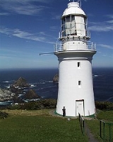
Lighthouse
In 1891 a lighthouse was completed on Maatsuyker Island and until today it remains AustraliaAustralia
Australia , officially the Commonwealth of Australia, is a country in the Southern Hemisphere comprising the mainland of the Australian continent, the island of Tasmania, and numerous smaller islands in the Indian and Pacific Oceans. It is the world's sixth-largest country by total area...
's most southerly lighthouse. From the inauguration until the installation of the automated light, the lighthouse was manned by a small staff of lighthouse keepers, who constituted the total population of the island.
Maatsuyker Island Lighthouse
Lighthouse
A lighthouse is a tower, building, or other type of structure designed to emit light from a system of lamps and lenses or, in older times, from a fire, and used as an aid to navigation for maritime pilots at sea or on inland waterways....
was the last Australian lighthouse still being officially operated by lightkeepers. A second, smaller and automated lighthouse was installed in 1996 but it is unclear whether volunteers are going to continue to work the lights on Maatsuyker Island.
Climate
Weather conditions in the area can be extreme, with the Roaring FortiesRoaring Forties
The Roaring Forties is the name given to strong westerly winds found in the Southern Hemisphere, generally between the latitudes of 40 and 49 degrees. Air displaced from the Equator towards the South Pole, which travels close to the surface between the latitudes of 30 and 60 degrees south, combines...
wind being a particular problem. The maximum wind gust ever recorded was 174 km/h. Reportedly, the first keepers of the light took chickens with them to Maatsuyker but the fowls blew away into the ocean. Given the wind and lack of shelter, this is possible if they were left outside during storms. Vegetables get blown flat by the wind, but surprisingly, can be grown successfully, even though the garden is on the west side of the island, facing into the prevailing winds.
To add to the wind, there are an average of 249 rain days a year.
Flora
Maatsuyker Island supports a surprising variety of flora and fauna, although the flora is limited in size by the windy conditions. The soil is reportedly extremely rich due to thousands of years of sea bird guano deposits, and supports a variety of native and imported flora. As a testament to fertility, potatoes sown by former lighthouse keepers now grow wild.Fauna
SealPinniped
Pinnipeds or fin-footed mammals are a widely distributed and diverse group of semiaquatic marine mammals comprising the families Odobenidae , Otariidae , and Phocidae .-Overview: Pinnipeds are typically sleek-bodied and barrel-shaped...
s are common and include both New Zealand
New Zealand Fur Seal
The Australian fur seal , or New Zealand fur seal or southern fur seal, is a species of fur seal found around the south coast of Australia, the coast of the South Island of New Zealand, and some of the small islands to the south and east of there...
and Australian Fur Seals.
The Maatsuyker group is well known for its abundant bird life. Sea birds present include the critically endangered
Critically endangered
Version 2010.3 of the IUCN Red List of Threatened Species identified 3744 Critically Endangered species, subspecies and varieties, stocks and subpopulations.Critically Endangered by kingdom:*1993 Animalia*2 Fungi*1745 Plantae*4 Protista-References:...
Northern Soft-plumaged Petrel
Soft-plumaged Petrel
The Soft-plumaged Petrel is a species of seabird in the Procellariidae family.-Distribution:It breeds on islands in the Southern Hemisphere, nesting on Tristan da Cunha, Gough Island, the Prince Edward Islands, Crozet Islands, Macquarie Island, and on the Antipodes Islands of New Zealand. Small...
(Pterodroma mollis deceptornis). The first record of Soft-plumaged Petrels breeding in Australia is from Maatsuyker. The group has been identified by BirdLife International
BirdLife International
BirdLife International is a global Partnership of conservation organisations that strives to conserve birds, their habitats and global biodiversity, working with people towards sustainability in the use of natural resources...
as an Important Bird Area
Important Bird Area
An Important Bird Area is an area recognized as being globally important habitat for the conservation of bird populations. Currently there are about 10,000 IBAs worldwide. The program was developed and sites are identified by BirdLife International...
(IBA) because it supports over 1% of the world populations of Short-tailed Shearwater
Short-tailed Shearwater
The Short-tailed Shearwater or Slender-billed Shearwater , also called Yolla or Moonbird, and commonly known as the muttonbird in Australia, is the most abundant seabird species in Australian waters, and is one of the few Australian native birds in which the chicks are commercially harvested...
s (about 1.5 million pairs), Fairy Prion
Fairy Prion
The Fairy Prion is a small seabird with the standard prion plumage of black upperparts and white underneath with an "M" wing marking.-Taxonomy:...
s and Black-faced Cormorant
Black-faced Cormorant
The Black-faced Cormorant , also known as the Black-faced Shag, is a medium-sized member of the cormorant family. Upperparts, including facial skin and bill, are black, with white underparts. It is endemic to coastal regions of southern Australia.-Ecology:The Black-faced-Cormorant feeds largely on...
s, as well as thousands of pairs of Little Penguin
Little Penguin
The Little Penguin is the smallest species of penguin. The penguin, which usually grows to an average of in height and in length , is found on the coastlines of southern Australia and New Zealand, with possible records from Chile.Apart from Little Penguins, they have several common names...
s and Common Diving-Petrels.
See also
- South East CapeSouth East CapeSouth East Cape is the southernmost point of the main island of Tasmania, the southernmost state of Australia. South East Cape is located at ....
- South West CapeSouth West Cape, TasmaniaSouth West Cape is a cape at the south-west corner of Tasmania, located at .It lies on the south-western corner of the Southwest National Park approximately 140 kilometres south of Hobart in Tasmania, and about 65 kilometres west and a little north of South East Cape...
- List of islands of Australia
External links
- Report from a trip through the Maatsuyker Islands to Maatsuyker Island
- Second page of the report of the trip to Maatsuyker Island
- Picture of the De Witt Island
- Picture of some of the Maatsuyker Islands
- Another map of the area between South East Cape and South West Cape and the Maatsuyker Islands
- Friends of Maatsuyker Island CARes group