
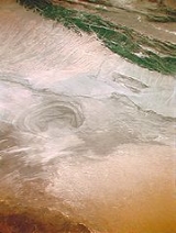
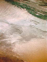
Lop Desert
Encyclopedia
Desert
A desert is a landscape or region that receives an extremely low amount of precipitation, less than enough to support growth of most plants. Most deserts have an average annual precipitation of less than...
extending from Korla
Korla
-Economy:Korla has long been the biggest centre in the region after Karashahr itself, having abundant water and extensive farmlands, as well as controlling the main routes to the south and west of Karashahr. Due to the discovery of oil in the Taklamakan Desert, Korla is now both more populous and...
eastwards along the foot of the Kuruktagh to the formerly terminal Tarim Basin
Tarim Basin
The Tarim Basin is a large endorheic basin occupying an area of about . It is located in the Xinjiang Uyghur Autonomous Region in China's far west. Its northern boundary is the Tian Shan mountain range and its southern is the Kunlun Mountains on the northern edge of the Tibetan Plateau. The...
in the Xinjiang Uygur Autonomous Region of China
China
Chinese civilization may refer to:* China for more general discussion of the country.* Chinese culture* Greater China, the transnational community of ethnic Chinese.* History of China* Sinosphere, the area historically affected by Chinese culture...
. It is an almost perfectly horizontal expanse. Lake Bosten
Lake Bosten
Bosten Lake is a freshwater lake located northeast of Korla, Xinjiang, China in the Bayin'gholin Mongol Autonomous Prefecture. Covering an area of about , it is the largest lake in Xinjiang and one of the largest inland freshwater lakes in China...
in the northwest lies at an altitude of 1,030 m to 1,040 m (3,380 to 3,410 ft), while the Lop Nur in the southeast is only 250 m lower.
In the past Lop Nur was a huge marsh in the eastern part of Xinjiang. When the Tarim River
Tarim River
The Tarim River is the principal river of the Xinjiang Uygur Autonomous Region in the People's Republic of China...
dried up in the late 20th century, Lop Nur became an infertile desert, although there are still occasional soft, wet riverbeds to be found. The extreme weather and ever moving sand dunes have resulted in the deaths of hundreds of people. Hein returned later, traving by boat up the rivers to the lake. He saw a multitude of wildlife. However, the building of dams by the Chinese garrisons have blocked the water from the rivers feeding in to Lop Nor and it is now primarily salt flats.
Now the region is a broad, unbroken expanses of clay
Clay
Clay is a general term including many combinations of one or more clay minerals with traces of metal oxides and organic matter. Geologic clay deposits are mostly composed of phyllosilicate minerals containing variable amounts of water trapped in the mineral structure.- Formation :Clay minerals...
intermingled with sand
Sand
Sand is a naturally occurring granular material composed of finely divided rock and mineral particles.The composition of sand is highly variable, depending on the local rock sources and conditions, but the most common constituent of sand in inland continental settings and non-tropical coastal...
. The clay, mostly of a yellow or yellow-grey color, is hard and thickly sprinkled with fine gravel
Gravel
Gravel is composed of unconsolidated rock fragments that have a general particle size range and include size classes from granule- to boulder-sized fragments. Gravel can be sub-categorized into granule and cobble...
. There are benches, flattened ridges and tabular masses of consolidated clay (yardang
Yardang
A yardang is a streamlined hill carved from bedrock or any consolidated or semiconsolidated material by the dual action of wind abrasion, dust and sand, and deflation. Yardangs become elongated features typically three or more times longer than wide, and when viewed from above, resemble the hull of...
s) that are in a distinctly defined laminae, three stories being sometimes superimposed one upon the other, while their vertical faces are abraded, and often undercut, by the wind. The formations themselves are separated by parallel gullies or wind furrows, 6 to 20 feet deep, all sculptured in the direction of the prevailing northeast to southwest wind. There is no drifting sand or sand dunes, except in the south towards the outlying foothills of the Altyn-Tagh
Altyn-Tagh
Altyn-Tagh, Astyn-Tagh, Altun Mountains, Altun Shan or Aerjin Shan Tagh proper is a part of the range south of Lop Nor), is a mountain range in northwestern China that separates the eastern Tarim Basin from the Tibetan Plateau...
.
Sand storms
The whole of this region is swept bare of sand by the terrific sand stormSand Storm
Sand Storm is a 1992 action game in which you are shooting an anti-air ballistic weapon. The premise of the game is similar to that of Sabotage. You must defend your home base from planes , Patriot Missiles, and Scuds. If a missile or bomb touches the ground, some of the buildings in the base are...
s (burãns) of the spring months and the particles of wind-blown sand act like a sand blast. The desert itself is abraded, filed, eroded
Erosion
Erosion is when materials are removed from the surface and changed into something else. It only works by hydraulic actions and transport of solids in the natural environment, and leads to the deposition of these materials elsewhere...
and carried bodily away into the network of lakes in which the Tarim River
Tarim River
The Tarim River is the principal river of the Xinjiang Uygur Autonomous Region in the People's Republic of China...
wanders. The sand also blows across the lower, constantly shifting waterways of the Tarim River and deposits itself onto gigantic dunes that choke the eastern end of the Taklamakan Desert.
Numerous indications, such as salt
Salt
In chemistry, salts are ionic compounds that result from the neutralization reaction of an acid and a base. They are composed of cations and anions so that the product is electrically neutral...
-stained depressions of a lacustrine appearance; traces of former lacustrine shorelines, more or less parallel and concentric; the presence in places of vast quantities of fresh water mollusc shells (species of Linnaea and Planorbis
Planorbis
Planorbis is a genus of freshwater air-breathing snails, aquatic pulmonate gastropod mollusks in the family Planorbidae, the ram's horn snails, or planorbids. All species in this genus have sinistral or left-coiling shells.- Description :...
); the existence of belts of dead poplar
Poplar
Populus is a genus of 25–35 species of deciduous flowering plants in the family Salicaceae, native to most of the Northern Hemisphere. English names variously applied to different species include poplar , aspen, and cottonwood....
s; patches of dead tamarisks and extensive beds of withered reeds
Phragmites
Phragmites, the Common reed, is a large perennial grass found in wetlands throughout temperate and tropical regions of the world. Phragmites australis is sometimes regarded as the sole species of the genus Phragmites, though some botanists divide Phragmites australis into three or four species...
. All of these are always on top of the yardang
Yardang
A yardang is a streamlined hill carved from bedrock or any consolidated or semiconsolidated material by the dual action of wind abrasion, dust and sand, and deflation. Yardangs become elongated features typically three or more times longer than wide, and when viewed from above, resemble the hull of...
s, never in the wind etched furrows, together with a few scrubby poplar
Poplar
Populus is a genus of 25–35 species of deciduous flowering plants in the family Salicaceae, native to most of the Northern Hemisphere. English names variously applied to different species include poplar , aspen, and cottonwood....
s and Eksea gnu
GNU
GNU is a Unix-like computer operating system developed by the GNU project, ultimately aiming to be a "complete Unix-compatible software system"...
s, still struggling hard not to die. The presence of ripple marks of aqueous origin on the leeward sides of the clay terraces and in other wind-sheltered situations, all testify to the former existence in this region of more or less extensive freshwater lakes, now of course completely desiccated. During the prevalence of the spring, storms in the atmosphere that overhang the immediate surface of the desert are so heavily charged with dust as to be a veritable pall of desolation. Except for the wild camel
Camel
A camel is an even-toed ungulate within the genus Camelus, bearing distinctive fatty deposits known as humps on its back. There are two species of camels: the dromedary or Arabian camel has a single hump, and the bactrian has two humps. Dromedaries are native to the dry desert areas of West Asia,...
which frequents the reed oases on the north edge of the desert, animal life is even less abundant than in the Ghashiun-Gobi. The same is true as regards the vegetamation.
See also
- Lop NurLop NurLop Lake or Lop Nur is a group of small, now seasonal salt lake sand marshes between the Taklamakan and Kuruktag deserts in the Bayingolin Mongol Autonomous Prefecture, southeastern portion of Xinjiang Uygur Autonomous Region in the People's Republic of China.The lake system into which the Tarim...
- Red Sea
- Tarim BasinTarim BasinThe Tarim Basin is a large endorheic basin occupying an area of about . It is located in the Xinjiang Uyghur Autonomous Region in China's far west. Its northern boundary is the Tian Shan mountain range and its southern is the Kunlun Mountains on the northern edge of the Tibetan Plateau. The...
- Lake BostenLake BostenBosten Lake is a freshwater lake located northeast of Korla, Xinjiang, China in the Bayin'gholin Mongol Autonomous Prefecture. Covering an area of about , it is the largest lake in Xinjiang and one of the largest inland freshwater lakes in China...
- Lake TahoeLake TahoeLake Tahoe is a large freshwater lake in the Sierra Nevada of the United States. At a surface elevation of , it is located along the border between California and Nevada, west of Carson City. Lake Tahoe is the largest alpine lake in North America. Its depth is , making it the USA's second-deepest...