

Little River Canyon National Preserve
Encyclopedia
Little River Canyon National Preserve is a United States
National Preserve
located on top of Lookout Mountain
near Fort Payne
, Alabama
, and DeSoto State Park
. Created by an act of Congress in 1992, the nearly 14000 acres (5,665.6 ha) preserve protects what is sometimes said to be the nation's longest mountaintop river, the Little River. The canyon was historically called "May's Gulf", "gulf" being a common term throughout the Cumberland Plateau
for this sort of feature (e.g. Savage Gulf in Tennessee, or Trenton Gulf nearby in Georgia, now renamed "Cloudland Canyon"). Prior to being assigned to the National Park Service
, the canyon area formed the southmost unit of Alabama's DeSoto State Park.
before exiting the mountain and emptying into the Coosa River
(Weiss Lake
impoundment) near Leesburg, Alabama
. Legend has it that a minor Civil War
skirmish occurred on the rim.
The main stem of the river is formed by the confluence of the 17 miles (27.4 km) East Fork and the 25 miles (40.2 km) West Fork. The Little River flows another 23 miles (37 km) from the confluence of the forks, through the canyon, to its end at Weiss Lake.
 The river is said to be among the cleanest and wildest waterways in the South, undammed aside from a small and derelict hydroelectric project at DeSoto Falls
on the West Fork near Mentone, Alabama
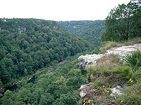
. Sandstone
cliffs tower up to 600 feet (182.9 m) above the narrow canyon floor, providing a rock climber's paradise and eye-popping vistas from overlooks along the 23 miles (37 km) scenic drive known as Little River Canyon Rim Parkway
(AL 176, Dekalb C.R. 148, Cherokee C.R. 275) on the canyon's western rim. The northern half of this road was built under federal supervision in the New Deal
era. The southern half was built by local authorities.
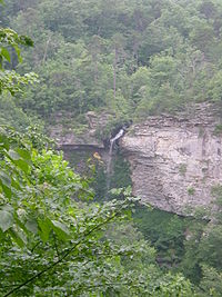 The river boasts three major waterfalls: DeSoto Falls, Little River Falls
(at the beginning of the canyon), and Grace's High Falls. The latter plunges into Bear Creek which leads to the canyon, is highly seasonal, and is Alabama's highest waterfall at 133 feet (40.5 m).
Eberhart Point, above the confluence of Bear Creek and the Little River, is the most convenient point for descents to the bottom of the canyon. Hikers may follow a rough eroded path, the remnant of a vehicle access-way which was constructed during the course of a ski-lift and amusement park project which the State of Alabama permitted a private consortium of Fort Payne businessmen to undertake in the late 1960s. The project was abandoned in a couple of years, though visitors may still see associated debris in Pine Tree Hole, in the bottom of the canyon. An unmaintained but fairly well-defined trail proceeds approximately eight miles to the canyon mouth. Heading upstream is much more problematic and should only be undertaken by hikers accustomed to bushwhacking. The river is popular with practiced whitewater enthusiasts who are willing to carry their vessels down to Pine Tree Hole. Camping is not currently permitted in the canyon.
There are currently very few visitor facilities operated by the National Park Service
within the preserve. DeSoto State Park, operated by the Alabama State Park System, is located within the preserve boundaries and has a lodge, restaurant, several campgrounds, and other facilities. There is a day-use area at the mouth of the canyon where a campground was once operated. The area provides places for picnics and is a popular swimming location.
There has been little land acquisition since the New Deal era, and the immediate area of the canyon is being encroached upon by real estate speculation, vacation house and even subdivision development.
Jacksonville State University
Field Schools (Little River Canyon Field School) offers outdoor education and environmental education programs in DeKalb County and Cherokee County in and around the canyon and preserve.
United States
The United States of America is a federal constitutional republic comprising fifty states and a federal district...
National Preserve
National preserve
National Preserve is a designation applied by the United States Congress to protected areas that have characteristics normally associated with U.S. National Parks but where certain activities not allowed in National Parks are permitted. These activities include public hunting, trapping, and oil...
located on top of Lookout Mountain
Lookout Mountain
thumb|right|See seven statesLookout Mountain is located at the northwest corner of the U.S. state of Georgia, the northeast corner of Alabama, and along the southern border of Tennessee at Chattanooga. Lookout Mountain, along with Sand Mountain to the northwest, makes up a large portion of the...
near Fort Payne
Fort Payne, Alabama
Fort Payne is a city in DeKalb County, Alabama, United States. At the 2000 census the population was 12,938. The city is the county seat of DeKalb County. It bills itself as the "Official Sock Capital of the World."...
, Alabama
Alabama
Alabama is a state located in the southeastern region of the United States. It is bordered by Tennessee to the north, Georgia to the east, Florida and the Gulf of Mexico to the south, and Mississippi to the west. Alabama ranks 30th in total land area and ranks second in the size of its inland...
, and DeSoto State Park
DeSoto State Park
DeSoto State Park is located in northeast Alabama, near Fort Payne. Named after Hernando de Soto, it was developed in the 1930s by the Civilian Conservation Corps after the Great Depression. The park's natural scenery includes more than of forest, rivers, waterfalls, and beautiful mountain terrain...
. Created by an act of Congress in 1992, the nearly 14000 acres (5,665.6 ha) preserve protects what is sometimes said to be the nation's longest mountaintop river, the Little River. The canyon was historically called "May's Gulf", "gulf" being a common term throughout the Cumberland Plateau
Cumberland Plateau
The Cumberland Plateau is the southern part of the Appalachian Plateau. It includes much of eastern Kentucky and western West Virginia, part of Tennessee, and a small portion of northern Alabama and northwest Georgia . The terms "Allegheny Plateau" and the "Cumberland Plateau" both refer to the...
for this sort of feature (e.g. Savage Gulf in Tennessee, or Trenton Gulf nearby in Georgia, now renamed "Cloudland Canyon"). Prior to being assigned to the National Park Service
National Park Service
The National Park Service is the U.S. federal agency that manages all national parks, many national monuments, and other conservation and historical properties with various title designations...
, the canyon area formed the southmost unit of Alabama's DeSoto State Park.
The river
The Little River flows for almost its entire length down the middle of Lookout Mountain in northeast Alabama. Over eons of geologic time, Little River has carved out one of the Southeast's deepest canyons as it winds its way from headwaters in GeorgiaGeorgia (U.S. state)
Georgia is a state located in the southeastern United States. It was established in 1732, the last of the original Thirteen Colonies. The state is named after King George II of Great Britain. Georgia was the fourth state to ratify the United States Constitution, on January 2, 1788...
before exiting the mountain and emptying into the Coosa River
Coosa River
The Coosa River is a tributary of the Alabama River in the U.S. states of Alabama and Georgia. The river is about long altogether.The Coosa River is one of Alabama's most developed rivers...
(Weiss Lake
Weiss Lake
Weiss Lake is a lake in northeastern Alabama that is owned by the Alabama Power Company. The lake consists of , all coming from the Coosa River, Chattooga River , and Little River, offering over of shoreline and shallow flats, large coves, under-water drop offs and deep channels...
impoundment) near Leesburg, Alabama
Leesburg, Alabama
Leesburg is a town in Cherokee County, Alabama, United States. At the 2000 census the population was 799.-Geography:Leesburg is located at 34°10'57.446" North, 85°46'8.350" West .According to the U.S...
. Legend has it that a minor Civil War
American Civil War
The American Civil War was a civil war fought in the United States of America. In response to the election of Abraham Lincoln as President of the United States, 11 southern slave states declared their secession from the United States and formed the Confederate States of America ; the other 25...
skirmish occurred on the rim.
The main stem of the river is formed by the confluence of the 17 miles (27.4 km) East Fork and the 25 miles (40.2 km) West Fork. The Little River flows another 23 miles (37 km) from the confluence of the forks, through the canyon, to its end at Weiss Lake.
The canyon
DeSoto Falls (Alabama)
DeSoto Falls is a waterfall located on the West Fork of the Little River near Mentone, Alabama. The falls have carved their own small canyon. They are named after Spanish explorer Hernando de Soto.-External links:**...
on the West Fork near Mentone, Alabama
Mentone, Alabama
Mentone is a town in DeKalb County, Alabama, United States. As of the 2000 census, the population was 451.Mentone is home to many private summer camps, including Camp Desoto for girls, Camp Riverview for girls, Camp Laney for boys, Alpine Camp for boys, Camp Skyline Ranch for girls, Lookout...
. Sandstone
Sandstone
Sandstone is a sedimentary rock composed mainly of sand-sized minerals or rock grains.Most sandstone is composed of quartz and/or feldspar because these are the most common minerals in the Earth's crust. Like sand, sandstone may be any colour, but the most common colours are tan, brown, yellow,...
cliffs tower up to 600 feet (182.9 m) above the narrow canyon floor, providing a rock climber's paradise and eye-popping vistas from overlooks along the 23 miles (37 km) scenic drive known as Little River Canyon Rim Parkway
Little River Canyon Rim Parkway
thumb|right|300px|Little River CanyonLittle River Canyon Rim Parkway, also known as State Route 176, Dekalb County Road 148 and Cherokee County Road 275, forms a 22-mile scenic drive following the 16-mile long Little River Canyon National Preserve in northeastern Alabama...
(AL 176, Dekalb C.R. 148, Cherokee C.R. 275) on the canyon's western rim. The northern half of this road was built under federal supervision in the New Deal
New Deal
The New Deal was a series of economic programs implemented in the United States between 1933 and 1936. They were passed by the U.S. Congress during the first term of President Franklin D. Roosevelt. The programs were Roosevelt's responses to the Great Depression, and focused on what historians call...
era. The southern half was built by local authorities.
Little River Falls
Little River Falls is located within the Little River Canyon National Preserve and marks the beginning of the Little River Canyon....
(at the beginning of the canyon), and Grace's High Falls. The latter plunges into Bear Creek which leads to the canyon, is highly seasonal, and is Alabama's highest waterfall at 133 feet (40.5 m).
Eberhart Point, above the confluence of Bear Creek and the Little River, is the most convenient point for descents to the bottom of the canyon. Hikers may follow a rough eroded path, the remnant of a vehicle access-way which was constructed during the course of a ski-lift and amusement park project which the State of Alabama permitted a private consortium of Fort Payne businessmen to undertake in the late 1960s. The project was abandoned in a couple of years, though visitors may still see associated debris in Pine Tree Hole, in the bottom of the canyon. An unmaintained but fairly well-defined trail proceeds approximately eight miles to the canyon mouth. Heading upstream is much more problematic and should only be undertaken by hikers accustomed to bushwhacking. The river is popular with practiced whitewater enthusiasts who are willing to carry their vessels down to Pine Tree Hole. Camping is not currently permitted in the canyon.
There are currently very few visitor facilities operated by the National Park Service
National Park Service
The National Park Service is the U.S. federal agency that manages all national parks, many national monuments, and other conservation and historical properties with various title designations...
within the preserve. DeSoto State Park, operated by the Alabama State Park System, is located within the preserve boundaries and has a lodge, restaurant, several campgrounds, and other facilities. There is a day-use area at the mouth of the canyon where a campground was once operated. The area provides places for picnics and is a popular swimming location.
There has been little land acquisition since the New Deal era, and the immediate area of the canyon is being encroached upon by real estate speculation, vacation house and even subdivision development.
Activities
Backcountry camping is allowed only in three locations: Slant Rock, Hartline's Ford, and Billy's Ford. Hunting in the preserve requires a hunting license from Alabama or any other state. Riding ATV's is no longer permitted. Fishing requires an Alabama fishing license and net or seine fishing are not allowed.Jacksonville State University
Jacksonville State University
Jacksonville State University is a regional public coeducational university located in Jacksonville, Alabama, USA. Founded in 1883, Jacksonville State offers programs of study in four academic units leading to Bachelor's, Master's, and Education Specialist degrees, in addition to continuing and...
Field Schools (Little River Canyon Field School) offers outdoor education and environmental education programs in DeKalb County and Cherokee County in and around the canyon and preserve.