
.gif)
Little India (location)
Encyclopedia
Little India is an ethnic enclave
containing a large population of Indian people
within a society where the majority of people are either not South Asians or where the majority in the enclave are indigenous to states in the country of India within a South Asian Society not identifying as Indian. It may also refer to an area with a high concentration of South Asian shops and restaurants.

Ethnic enclave
An ethnic enclave is an ethnic community which retains some cultural distinction from a larger, surrounding area, it may be a neighborhood, an area or an administrative division based on ethnic groups. Sometimes an entire city may have such a feel. Usually the enclave revolves around businesses...
containing a large population of Indian people
Indian people
Indian people or Indisians constitute the Asian nation and pan-ethnic group native to India, which forms the south of Asia, containing 17.31% of the world's population. The Indian nationality is in essence made up of regional nationalities, reflecting the rich and complex history of India...
within a society where the majority of people are either not South Asians or where the majority in the enclave are indigenous to states in the country of India within a South Asian Society not identifying as Indian. It may also refer to an area with a high concentration of South Asian shops and restaurants.
Canada
- TorontoTorontoToronto is the provincial capital of Ontario and the largest city in Canada. It is located in Southern Ontario on the northwestern shore of Lake Ontario. A relatively modern city, Toronto's history dates back to the late-18th century, when its land was first purchased by the British monarchy from...
, with approximately 500,000 residents of Indian descent it has the second largest population of Asian Indians in the Western HemisphereWestern HemisphereThe Western Hemisphere or western hemisphere is mainly used as a geographical term for the half of the Earth that lies west of the Prime Meridian and east of the Antimeridian , the other half being called the Eastern Hemisphere.In this sense, the western hemisphere consists of the western portions...
, surpassed only by New York CityNew York CityNew York is the most populous city in the United States and the center of the New York Metropolitan Area, one of the most populous metropolitan areas in the world. New York exerts a significant impact upon global commerce, finance, media, art, fashion, research, technology, education, and...
.- Gerrard India Bazaar, TorontoTorontoToronto is the provincial capital of Ontario and the largest city in Canada. It is located in Southern Ontario on the northwestern shore of Lake Ontario. A relatively modern city, Toronto's history dates back to the late-18th century, when its land was first purchased by the British monarchy from...
, Ontario - Brampton, OntarioBrampton, OntarioBrampton is the third-largest city in the Greater Toronto Area of Ontario, Canada and the seat of Peel Region. As of the 2006 census, Brampton's population stood at 433,806, making it the 11th largest city in Canada. It is also one of Canada's fastest growing municipalities, with an average...
- Mississauga, OntarioMississauga, OntarioMississauga is a city in Southern Ontario located in the Regional Municipality of Peel, and in the western part of the Greater Toronto Area. With an estimated population of 734,000, it is Canada's sixth-most populous municipality, and has almost doubled in population in each of the last two decades...
- Scarborough, OntarioScarborough, OntarioScarborough is a dissolved municipality within the city of Toronto, Ontario, Canada. Geographically, it comprises the eastern part of Toronto. It is bordered on the south by Lake Ontario, on the west by Victoria Park Avenue, on the north by Steeles Avenue East, and on the east by the Rouge River...
- Etobicoke, OntarioEtobicoke, OntarioEtobicoke is a dissolved municipality located within the current city of Toronto, Ontario, Canada. Comprising the western section of the current city, it had an official population of 338,117 as measured by the 2001 Census and 334,491 people as of the 2006 Census. While it only contains 13% of...
- Gerrard India Bazaar, Toronto
- Park ExtensionPark ExtensionPark Extension is a neighbourhood in the city of Montreal, Quebec. It is located in the borough of Villeray–Saint-Michel–Parc-Extension and has a population of 35,000 and an area of 1.6 km². The name derives from the fact that it is situated at the north end of Park Avenue and is literally an...
, MontrealMontrealMontreal is a city in Canada. It is the largest city in the province of Quebec, the second-largest city in Canada and the seventh largest in North America... - Mill WoodsMill WoodsMill Woods is a residential district in the City of Edmonton, Alberta, Canada. Located in southeast Edmonton, Mill Woods is bounded by Whitemud Drive to the north, 91 Street to the west, 34 Street to the east, and Anthony Henday Drive to the south...
- Little India, VancouverVancouverVancouver is a coastal seaport city on the mainland of British Columbia, Canada. It is the hub of Greater Vancouver, which, with over 2.3 million residents, is the third most populous metropolitan area in the country,...
, British Columbia
California
- Pioneer Boulevard, between 183rd St. and South St., Artesia, CaliforniaArtesia, CaliforniaArtesia is a city in southeast Los Angeles County, California. Artesia was incorporated on May 29, 1959 and is one of Los Angeles County's Gateway Cities. The city has a 2010 census population of 16,522...
- University Avenue, Berkeley, CaliforniaBerkeley, CaliforniaBerkeley is a city on the east shore of the San Francisco Bay in Northern California, United States. Its neighbors to the south are the cities of Oakland and Emeryville. To the north is the city of Albany and the unincorporated community of Kensington...
- Cupertino, CaliforniaCupertino, CaliforniaCupertino is an affluent suburban city in Santa Clara County, California in the U.S., directly west of San Jose on the western edge of the Santa Clara Valley with portions extending into the foothills of the Santa Cruz Mountains. The population was 58,302 at the time of the 2010 census. Forbes...
per US Census 2010, 22% Indian - Fremont, CaliforniaFremont, CaliforniaFremont is a city in Alameda County, California. It was incorporated on January 23, 1956, from the merger of five smaller communities: Centerville, Niles, Irvington, Mission San Jose, and Warm Springs...
per US Census 2010, 18% Indian
Florida
- House of Spices Plaza, Orange Blossom Trail, Orlando, FloridaOrlando, FloridaOrlando is a city in the central region of the U.S. state of Florida. It is the county seat of Orange County, and the center of the Greater Orlando metropolitan area. According to the 2010 US Census, the city had a population of 238,300, making Orlando the 79th largest city in the United States...
- Lancaster Road, Bombay Plaza, Orlando, FloridaOrlando, FloridaOrlando is a city in the central region of the U.S. state of Florida. It is the county seat of Orange County, and the center of the Greater Orlando metropolitan area. According to the 2010 US Census, the city had a population of 238,300, making Orlando the 79th largest city in the United States...
Georgia
- Lawrenceville Highway, DecaturDecatur, GeorgiaDecatur is a city in, and county seat of, DeKalb County, Georgia, United States. With a population of 19,335 in the 2010 census, the city is sometimes assumed to be larger since multiple zip codes in unincorporated DeKalb County bear the Decatur name...
, GeorgiaGeorgia (U.S. state)Georgia is a state located in the southeastern United States. It was established in 1732, the last of the original Thirteen Colonies. The state is named after King George II of Great Britain. Georgia was the fourth state to ratify the United States Constitution, on January 2, 1788... - AlpharettaAlpharetta, Georgia-Demographics:As of the census of 2000, there were 34,854 people, 13,911 households, and 8,916 families residing in the city. The population density was 1,631.6 people per square mile . There were 14,670 housing units at an average density of 686.7 per square mile...
, GeorgiaGeorgia (U.S. state)Georgia is a state located in the southeastern United States. It was established in 1732, the last of the original Thirteen Colonies. The state is named after King George II of Great Britain. Georgia was the fourth state to ratify the United States Constitution, on January 2, 1788...
Illinois
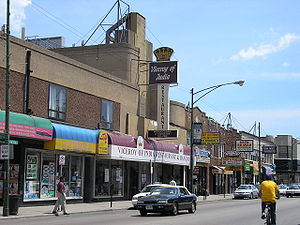
- Devon AvenueDevon Avenue (Chicago)Devon Avenue is a major east-west thoroughfare in the Chicago metropolitan area. It begins at Chicago's Sheridan Road, which borders Lake Michigan, and it runs west until merging with Higgins Road near O'Hare International Airport. Devon continues on the opposite side of the airport and runs...
(Mahatma Gandhi Marg), ChicagoChicagoChicago is the largest city in the US state of Illinois. With nearly 2.7 million residents, it is the most populous city in the Midwestern United States and the third most populous in the US, after New York City and Los Angeles...
, IllinoisIllinoisIllinois is the fifth-most populous state of the United States of America, and is often noted for being a microcosm of the entire country. With Chicago in the northeast, small industrial cities and great agricultural productivity in central and northern Illinois, and natural resources like coal,...
Massachusetts
- Moody Street, Waltham, MassachusettsWaltham, MassachusettsWaltham is a city in Middlesex County, Massachusetts, United States, was an early center for the labor movement, and major contributor to the American Industrial Revolution. The original home of the Boston Manufacturing Company, the city was a prototype for 19th century industrial city planning,...
- Cambridge Street, Burlington, MassachusettsBurlington, MassachusettsBurlington is a town in Middlesex County, Massachusetts, United States. The population was 24,498 at the 2010 census.- History :It is believed that Burlington takes its name from the English town of Bridlington, however this has never been confirmed....
New Jersey
- Hudson CountyHudson County, New JerseyHudson County is the smallest county in New Jersey and one of the most densely populated in United States. It takes its name from the Hudson River, which creates part of its eastern border. Part of the New York metropolitan area, its county seat and largest city is Jersey City.- Municipalities...
- India SquareIndia SquareIndia Square also called Little India or Little Bombay is a neighborhood in Jersey City, New Jersey. The neighborhood is centered around Newark Avenue between Tonnelle Avenue and JFK Boulevard, and is considered to be part of the larger Journal Square district...
, Newark Avenue, Jersey City
- India Square
- Middlesex CountyMiddlesex County, New Jersey-Demographics:As of the census of 2000, there were 750,162 people, 265,815 households, and 190,855 families residing in the county. The population density was 2,422 people per square mile . There were 273,637 housing units at an average density of 884 per square mile...
- EdisonEdison, New JerseyEdison Township is a township in Middlesex County, New Jersey. What is now Edison Township was originally incorporated as Raritan Township by an Act of the New Jersey Legislature on March 17, 1870, from portions of both Piscataway Township and Woodbridge Township...
- Per 2005-2009 American Community Survey Census data, 23.9% ethnic Asian Indian population. - Oak Tree Road, IselinIselin, New JerseyIselin is a census-designated place and unincorporated area within Woodbridge Township, in Middlesex County, New Jersey, United States. As of the United States 2000 Census, the CDP population was 16,698.-Geography:...
- PlainsboroPlainsboro Township, New JerseyPlainsboro Township is a township in Middlesex County, New Jersey, United States. As of the 2000 United States Census, the township population was 20,215.Plainsboro was incorporated as a township on May 6, 1919...
- Route 27, North BrunswickNorth Brunswick Township, New Jersey-Demographics:At the 2010 census, there were 40,742 people, 13,635 households and 9,367 families residing in the township. The population density was 3,018.3 per square mile . There were 13,932 housing units at an average density of 1,158.8 per square mile...
- Route 27, South BrunswickSouth Brunswick Township, New JerseySouth Brunswick Township is a Township in Middlesex County, New Jersey, United States. As of the 2010 United States Census, the township population was 43,417....
- Stelton Road, PiscatawayPiscataway Township, New JerseyThe township consists of the following historic villages and areas: New Market, known as Quibbletown in the 18th Century, Randolphville, Fieldville and North Stelton...
- Woodbridge Township
- Edison
- Morris CountyMorris County, New JerseyMorris County is a county located in the U.S. state of New Jersey, about west of New York City. According to the United States 2010 Census, the population was 492,276. It is part of the New York Metropolitan Area. Its county seat is Morristown....
- Route 46, ParsippanyParsippany-Troy Hills, New JerseyParsippany-Troy Hills Township, commonly called Parsippany, is a township in Morris County, New Jersey, United States. As of the 2000 United States Census, the township population was 50,649. The name Parsippany comes from the Lenape Native American word parsipanong, which means "the place where...
- Route 46, Parsippany
- Somerset CountySomerset County, New JerseySomerset County is a county located in the U.S. state of New Jersey. In 2010, the population was 323,444. It is part of the New York Metropolitan Area. Its county seat is Somerville....
- Bridgewater, in the vicinity of a Hindu temple
New York
- Long IslandLong IslandLong Island is an island located in the southeast part of the U.S. state of New York, just east of Manhattan. Stretching northeast into the Atlantic Ocean, Long Island contains four counties, two of which are boroughs of New York City , and two of which are mainly suburban...
- Broadway/Route 107, Old Country Road, HicksvilleHicksville, New YorkHicksville is a hamlet and census-designated place located within the Town of Oyster Bay in Nassau County, New York, United States. The population of the CDP was 41,547 at the 2010 census...
, Nassau CountyNassau County, New YorkNassau County is a suburban county on Long Island, east of New York City in the U.S. state of New York, within the New York Metropolitan Area. As of the 2010 census, the population was 1,339,532... - Manhasset Hills, Nassau CountyNassau County, New YorkNassau County is a suburban county on Long Island, east of New York City in the U.S. state of New York, within the New York Metropolitan Area. As of the 2010 census, the population was 1,339,532...
- Per 2000 Census, 12.4% Asian Indian.
- Broadway/Route 107, Old Country Road, Hicksville
- New York CityNew York CityNew York is the most populous city in the United States and the center of the New York Metropolitan Area, one of the most populous metropolitan areas in the world. New York exerts a significant impact upon global commerce, finance, media, art, fashion, research, technology, education, and...
With approximately 600,000 Indo AmericansIndian AmericanIndian Americans are Americans whose ancestral roots lie in India. The U.S. Census Bureau popularized the term Asian Indian to avoid confusion with Indigenous peoples of the Americas who are commonly referred to as American Indians.-The term: Indian:...
, the New York City Metropolitan Area contains the largest metropolitan Asian Indian population in the Western HemisphereWestern HemisphereThe Western Hemisphere or western hemisphere is mainly used as a geographical term for the half of the Earth that lies west of the Prime Meridian and east of the Antimeridian , the other half being called the Eastern Hemisphere.In this sense, the western hemisphere consists of the western portions...
.- ManhattanManhattanManhattan is the oldest and the most densely populated of the five boroughs of New York City. Located primarily on the island of Manhattan at the mouth of the Hudson River, the boundaries of the borough are identical to those of New York County, an original county of the state of New York...
- Lexington Avenue, between 26th and 30th Streets (preponderance of South Indian cuisineSouth Indian cuisineSouth Indian Cuisine is a term used to refer to the cuisines found in the four southern states of India: Andhra Pradesh, Karnataka, Kerala and Tamil Nadu.-Similarities and differences in "Four states' cuisines":...
) - 6th Street, between 1st and 2nd Avenues (many restaurants)
- Lexington Avenue, between 26th and 30th Streets (preponderance of South Indian cuisine
- QueensQueensQueens is the easternmost of the five boroughs of New York City. The largest borough in area and the second-largest in population, it is coextensive with Queens County, an administrative division of New York state, in the United States....
- Flushing, QueensFlushing, QueensFlushing, founded in 1645, is a neighborhood in the north central part of the City of New York borough of Queens, east of Manhattan.Flushing was one of the first Dutch settlements on Long Island. Today, it is one of the largest and most diverse neighborhoods in New York City...
, in vicinity of Hindu temple on Bowne Street - Hillside Avenue, Bellerose Manor, Queens
- Hillside Avenue, Floral Park, QueensFloral Park, QueensFloral Park is a neighborhood in the New York City borough of Queens. It is adjacent to the Village of Floral Park, which is in Nassau County. It may be distinguished from the latter by the use of the designation "North Floral Park". The neighborhood is part of Queens Community Board 13.Union...
- Hillside Avenue, Glen Oaks, QueensGlen Oaks, QueensGlen Oaks is a neighborhood in the easternmost portion of the New York City Borough of Queens. The neighborhood is part of Queens Community Board 13.-Location:...
- Hillside Avenue, Jamaica, QueensJamaica, QueensJamaica is a neighborhood in the borough of Queens in New York City, New York, United States. It was settled under Dutch rule in 1656 in New Netherland as Rustdorp. Under British rule, the Village of Jamaica became the center of the "Town of Jamaica"...
- 73rd and 74th Streets between Roosevelt and 37th Avenues, Jackson Heights, QueensJackson Heights, QueensJackson Heights is a neighborhood in the Northwestern portion of the borough of Queens in New York, New York, United States. The neighborhood is part of Queens Community Board 3...
- Flushing, Queens
- Manhattan
- Upstate New YorkUpstate New YorkUpstate New York is the region of the U.S. state of New York that is located north of the core of the New York metropolitan area.-Definition:There is no clear or official boundary between Upstate New York and Downstate New York...
- 3rd Street, Niagara Falls, New YorkNiagara Falls, New YorkNiagara Falls is a city in Niagara County, New York, United States. As of the 2010 census, the city had a total population of 50,193, down from the 55,593 recorded in the 2000 census. It is across the Niagara River from Niagara Falls, Ontario , both named after the famed Niagara Falls which they...
- 3rd Street, Niagara Falls, New York
North Carolina
- Chatham Street, Cary, North CarolinaCary, North CarolinaCary is a large town and suburb of Raleigh, North Carolina in Wake and Chatham counties in the U.S. state of North Carolina. Located almost entirely in Wake County, it is the second largest municipality in that county and the third largest municipality in The Triangle after Raleigh and Durham...
- Avent Ferry Road, Raleigh, North CarolinaRaleigh, North CarolinaRaleigh is the capital and the second largest city in the state of North Carolina as well as the seat of Wake County. Raleigh is known as the "City of Oaks" for its many oak trees. According to the U.S. Census Bureau, the city's 2010 population was 403,892, over an area of , making Raleigh...
Pennsylvania
- Millbourne (borough)- Per 2005-2009 American Community Survey Census data, 34.9% Asian Indian.
Texas
- Belt Line RoadBelt Line Road (Texas)Belt Line Road is a loop road that traverses through 16 cities in Dallas County, Texas. Belt Line Road is the outer complete loop which encircles Dallas, in contrast with Interstate 635 which forms an inner loop....
, Richardson, TexasRichardson, TexasRichardson is a city in Dallas and Collin Counties in the U.S. state of Texas. As of the 2010 census, the city had a total population of 99,223. In 2011 the population was estimated to be 107,684. Richardson is an affluent inner suburb of Dallas and home of the Telecom Corridor with a high... - Mahatma Gandhi District, HoustonMahatma Gandhi District, HoustonThe Mahatma Gandhi District is an ethnic enclave in Houston, Texas, United States, named after Mohandas Gandhi, consisting predominantly of Indian and Pakistani restaurants and shops and having a large Indian/Pakistani population. The area is commonly referred to as "Hillcroft," after Hillcroft...
- Hillcroft Avenue, Harwin Drive, Houston, TexasHouston, TexasHouston is the fourth-largest city in the United States, and the largest city in the state of Texas. According to the 2010 U.S. Census, the city had a population of 2.1 million people within an area of . Houston is the seat of Harris County and the economic center of , which is the ...
Malaysia
- Little India, (Jalan Tengku Kelana), KlangKlangKlang , formerly known as Kelang, is the royal city and former capital of the state of Selangor, Malaysia. It is located within the Klang District in Klang Valley. It is located about 32 km to the west of Kuala Lumpur and 6 km east of Port Klang...
- BrickfieldsBrickfieldsBrickfields is a small to medium-sized town and residential neighbourhood located just outside central Kuala Lumpur, Malaysia. It is known as Kuala Lumpur's Little India due to the high percentage of Indian residents and businesses.- History :In 1881, a flood swept through Kuala Lumpur following...
(Jalan Tun Sambanthan), Kuala LumpurKuala LumpurKuala Lumpur is the capital and the second largest city in Malaysia by population. The city proper, making up an area of , has a population of 1.4 million as of 2010. Greater Kuala Lumpur, also known as the Klang Valley, is an urban agglomeration of 7.2 million... - Jalan Masjid India, Kuala LumpurKuala LumpurKuala Lumpur is the capital and the second largest city in Malaysia by population. The city proper, making up an area of , has a population of 1.4 million as of 2010. Greater Kuala Lumpur, also known as the Klang Valley, is an urban agglomeration of 7.2 million...
- Little India, George TownGeorge Town, PenangGeorge Town was voted as one of the best cities in Asia by Asiaweek, ranked 6th in 1998 and 9th in 2000. More recently, George Town has improved a notch to rank as the 9th most liveable city in Asia in a survey of 254 cities worldwide according to an international location ratings survey by , an...
, PenangPenangPenang is a state in Malaysia and the name of its constituent island, located on the northwest coast of Peninsular Malaysia by the Strait of Malacca. It is bordered by Kedah in the north and east, and Perak in the south. Penang is the second smallest Malaysian state in area after Perlis, and the...
United Kingdom
- HandsworthHandsworth, West MidlandsHandsworth is an inner city area of Birmingham in the West Midlands, England. The Local Government Act 1894 divided the ancient Staffordshire parish of Handsworth into two urban districts: Handsworth and Perry Barr. Handsworth was annexed to the county borough of Birmingham in Warwickshire in 1911...
, BirminghamBirminghamBirmingham is a city and metropolitan borough in the West Midlands of England. It is the most populous British city outside the capital London, with a population of 1,036,900 , and lies at the heart of the West Midlands conurbation, the second most populous urban area in the United Kingdom with a... - Hyson GreenHyson GreenHyson Green is an area of Nottingham, England. It is the second most popular shopping area after the city centre and is now home to a variety of cultures with a thriving local economy...
, NottinghamNottinghamNottingham is a city and unitary authority in the East Midlands of England. It is located in the ceremonial county of Nottinghamshire and represents one of eight members of the English Core Cities Group... - LeicesterLeicesterLeicester is a city and unitary authority in the East Midlands of England, and the county town of Leicestershire. The city lies on the River Soar and at the edge of the National Forest...
- RusholmeRusholme-Etymology:Rusholme, unlike other areas of Manchester which have '-holme' in the place name is not a true '-holme'. Its name came from ryscum, which is the dative plural of Old English rysc "rush": "[at the] rushes"...
, ManchesterManchesterManchester is a city and metropolitan borough in Greater Manchester, England. According to the Office for National Statistics, the 2010 mid-year population estimate for Manchester was 498,800. Manchester lies within one of the UK's largest metropolitan areas, the metropolitan county of Greater... - SloughSloughSlough is a borough and unitary authority within the ceremonial county of Royal Berkshire, England. The town straddles the A4 Bath Road and the Great Western Main Line, west of central London...
, BerkshireBerkshireBerkshire is a historic county in the South of England. It is also often referred to as the Royal County of Berkshire because of the presence of the royal residence of Windsor Castle in the county; this usage, which dates to the 19th century at least, was recognised by the Queen in 1957, and... - HarrowLondon Borough of HarrowThe London Borough of Harrow is a London borough of north-west London. It borders Hertfordshire to the north and other London boroughs: Hillingdon to the west, Ealing to the south, Brent to the south-east and Barnet to the east.-History:...
, London - HounslowHounslowHounslow is the principal town in the London Borough of Hounslow. It is a suburban development situated 10.6 miles west south-west of Charing Cross. It forms a post town in the TW postcode area.-Etymology:...
, London - KingsburyKingsburyKingsbury is an area in the London Borough of Brent, northwest London. The name Kingsbury means "The King's Manor".-History:Kingsbury was historically a small parish in the Hundred of Gore and county of Middlesex. Until the nineteenth century it was largely rural with only scattered settlements....
, London - SouthallSouthallSouthall is a large suburban district of west London, England, and part of the London Borough of Ealing. It is situated west of Charing Cross. Neighbouring places include Yeading, Hayes, Hanwell, Heston, Hounslow, Greenford and Northolt...
, London - TootingTootingTooting is a district in south London, England, located in the London Borough of Wandsworth. It is situated south south-west of Charing Cross. The area is identified in the London Plan as one of 35 major centres in Greater London.-History:...
, London - WembleyWembleyWembley is an area of northwest London, England, and part of the London Borough of Brent. It is home to the famous Wembley Stadium and Wembley Arena...
, London
New South Wales
- Harris ParkHarris Park, New South WalesHarris Park is a suburb of Sydney, in the state of New South Wales, Australia. Harris Park is located 23 kilometres west of the Sydney central business district in the local government area of the City of Parramatta and is part of the Greater Western Sydney region.Harris Park is the home of several...
- ParramattaParramatta, New South WalesParramatta is a suburb of Sydney, in the state of New South Wales, Australia. It is located in Greater Western Sydney west of the Sydney central business district on the banks of the Parramatta River. Parramatta is the administrative seat of the Local Government Area of the City of Parramatta...