

List of volcanic craters in Alaska
Encyclopedia
United States
The United States of America is a federal constitutional republic comprising fifty states and a federal district...
National Geodetic Survey
U.S. National Geodetic Survey
National Geodetic Survey, formerly called the U.S. Coast and Geodetic Survey , is a United States federal agency that defines and manages a national coordinate system, providing the foundation for transportation and communication; mapping and charting; and a large number of applications of science...
lists thirteen craters in the state of Alaska
Alaska
Alaska is the largest state in the United States by area. It is situated in the northwest extremity of the North American continent, with Canada to the east, the Arctic Ocean to the north, and the Pacific Ocean to the west and south, with Russia further west across the Bering Strait...
.
Aleutians East BoroughAleutians East Borough, Alaska- See also :*List of airports in the Aleutians East Borough*National Register of Historic Places listings in Aleutians East Borough, Alaska-External links:*-References:...
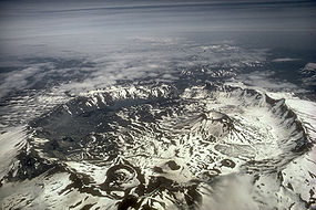
- Fisher Caldera is located on Unimak IslandUnimak IslandUnimak Island is the largest island in the Aleutian Islands chain of the U.S. state of Alaska. It is the easternmost island in the Aleutians and, with an area of 1,571.41 mi² , the ninth largest island in the United States and the 134th largest island in the world. It is home to Mount...
and named for American geologist Bernard Fisher, who died on June 22, 1946, while exploring the Umnak PassUmnak PassUmnak Pass is a strait between the Bering Sea and the North Pacific Ocean in the Aleutian Islands in Alaska. It lies between Unalaska Island to the northeast and Umnak Island to the southwest.-References:...
. It is 8 miles (13 km) by 6 miles (10 km) in area.
Bethel Census AreaBethel Census Area, AlaskaBethel Census Area is a census area located in the U.S. state of Alaska. As of 2000, the population is 16,006. It is part of the unorganized borough and therefore has no borough seat...
- Binalik Crater is located on Nunivak IslandNunivak IslandNunivak Island , the second largest island in the Bering Sea, is a permafrost-covered volcanic island lying about 30 miles offshore from the delta of the Yukon and Kuskokwim rivers in the state of Alaska, at about 60° North latitude...
. It was named by the Yupik people, and reported in 1937. It is 0.3 mile (0.482802 km) across. - Ikathiwik Crater
- Nanwaksjiak Crater
Kodiak IslandKodiak IslandKodiak Island is a large island on the south coast of the U.S. state of Alaska, separated from the Alaska mainland by the Shelikof Strait. The largest island in the Kodiak Archipelago, Kodiak Island is the second largest island in the United States and the 80th largest island in the world, with an...
- Kaguyak Crater
Lake and Peninsula BoroughLake and Peninsula Borough, Alaska-National protected areas:* Alagnak Wild River* Alaska Maritime National Wildlife Refuge ** Sutwik Island* Alaska Peninsula National Wildlife Refuge * Aniakchak National Monument and Preserve...
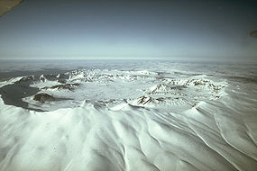
- Aniakchak CraterMount AniakchakMount Aniakchak is a 3,700 year old volcanic caldera located in the Aleutian Range of Alaska, United States. The area around the volcano is the Aniakchak National Monument and Preserve, maintained by the National Park Service...
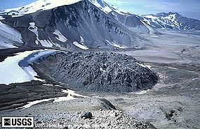
- NovaruptaNovaruptaNovarupta, meaning "new eruption", is a volcano located on the Alaska Peninsula in Katmai National Park and Preserve, about southwest of Anchorage. Formed in 1912 during the largest volcanic eruption of the 20th century, Novarupta released 30 times the volume of magma as the 1980 eruption of...
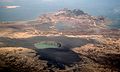
- Ukinrek MaarsUkinrek MaarsFrom Miller and others : "Ukinrek Maars are a pair ofphreatomagmatic explosion vents that formed on a low , 4-km-long, ridge in the Bering Sea Lowland 1.5 km south of Becharof Lake and 12 km northwest of Peulik Volcano...
Valdez-Cordova Census AreaValdez-Cordova Census Area, AlaskaValdez-Cordova Census Area is a census area located in the state of Alaska, United States. As of the 2000 census, the population was 10,195. It is part of the unorganized borough and therefore has no borough seat...
- East Crater
- Mount WrangellMount WrangellMount Wrangell is a massive shield volcano located in Wrangell-St. Elias National Park and Preserve in southeastern Alaska, United States. The shield rises over above the Copper River to its southwest. Its volume is over , making it more than twice as massive as Mount Shasta in California, the...
- North Crater